Penrhos Leisure Village - Environmental Statement Volume 1: Non Technical Summary - National Infrastructure Planning
←
→
Page content transcription
If your browser does not render page correctly, please read the page content below
Penrhos Leisure Village

                                                                  Environmental Statement Volume 1:
                                                                  Non Technical Summary

                                                                  November 2012

Environmental Statement Volume 1- Non Technical Summary .indd 1                                       8/11/12 09:04:48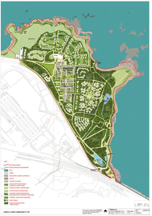
PENRHOS LEISURE VILLAGE

    LAND AND LAKES (ANGLESEY) LTD

 ENVIRONMENTAL IMPACT ASSESSMENT
 VOLUME 1: NON TECHNICAL SUMMARY

               NOVEMBER 2012

HOW Planning LLP, 40 Peter Street, Manchester, M2 5GP
Contact Partner: Gary Halman Telephone: 0161 835 1333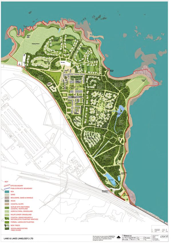
CONTENTS
                                                  Page

1.    Introduction                                   2
2.    EIA Approach and Methodology                   2
3.    Site Location                                  3
4.    Alternatives and Design Evolution              4
5.    Description of the Development                 4
6.    Construction                                   5
7.    Planning Policy Context                        6
8.    Socioeconomics, Regeneration and Health        6
9.    Landscape and Visual                           7
10.   Ecology and Nature Conservation                7
11.   Archaeology and Heritage                       8
12.   Ground Conditions                              9
13.   Drainage and Flood Risk                        9
14.   Transport and Access                          10
15.   Air Quality and Dust                          10
16.   Noise and Vibration                           10
17.   Waste                                         11
18.   Lighting                                      11
19.   Utilities                                     12
20.   Cumulative Impacts                            13
21.   Residual Impacts and Conclusions              13
22.   ES Availability and Comments                  14

Figure 1: Site Location Plan

Figure 2: Penrhos Masterplan

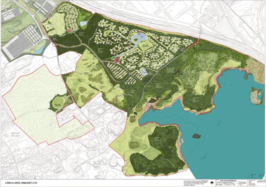
Figure 3: Cae Glas Masterplan

Figure 4: Kingsland Masterplan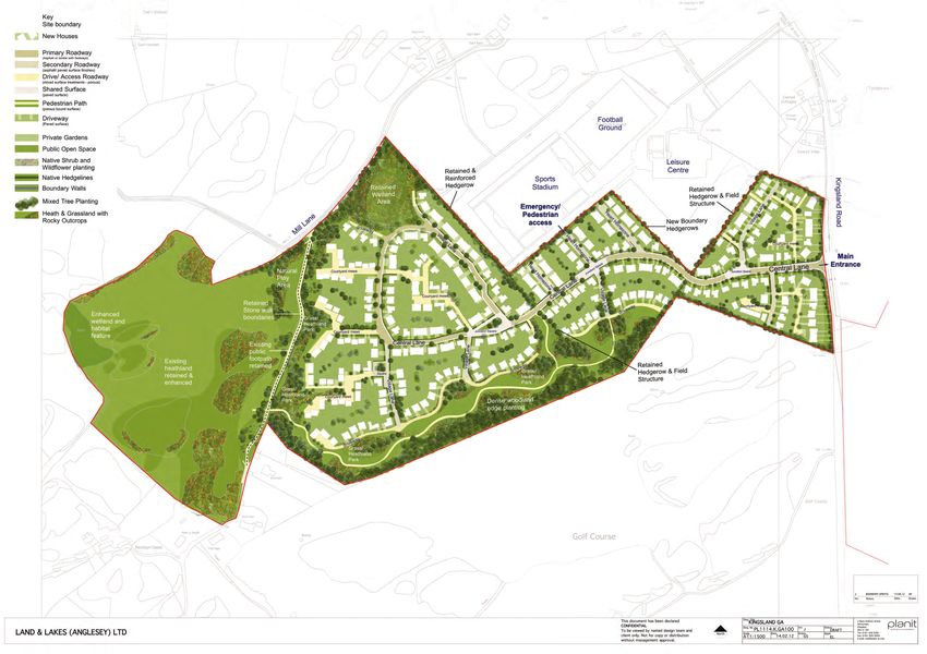
Penrhos Leisure Village                                   ES Volume 1: Non Technical Summary

1.      Introduction

Land and Lakes (Anglesey) Ltd (the Applicant) is seeking to obtain outline planning
permission for a leisure village and residential development located on Holy Island on
Anglesey.

HOW Planning LLP has been commissioned to oversee an Environmental Impact
Assessment (EIA) for the proposed development and specialist consultants were
appointed to investigate the environmental effects of the proposals. An Environmental
Statement (ES), which summarises the findings of the EIA, has been prepared to
accompany the planning application. The ES provides the Local Planning Authority with
detailed information on the potential environmental effects of the proposed development.

This document is the Non Technical Summary and is Volume 1 of the ES. It has been
prepared by HOW Planning LLP in accordance with the Town and Country Planning
(Environmental Impact Assessment) (England and Wales) Regulations 1999.

2.      EIA Approach and Methodology

An EIA seeks to predict the positive and negative environmental impacts associated with
a development proposal to provide the Local Planning Authority with sufficient
information to make an informed decision on the granting of planning consent.

The need for an EIA to evaluate the potential environmental effects of the proposals was
established by way of a formal ‘screening’ enquiry to the Isle of Anglesey County Council
(IOACC). The response to this enquiry confirmed the need for an EIA on the basis of the
scale of the development and the potential for environmental impacts to arise.

The range of studies required and the approach to each was established through a
‘scoping’ study. This involved a site walkover, initial desk based research and
consultation with IOACC. A Scoping Report summarising the findings of these
investigations was submitted to IOACC, who confirmed that the environmental topics that
required further assessment as part of the EIA were as follows:

    Socioeconomics, Regeneration and Health
    Landscape and Visual Impacts
    Ecology and Nature Conservation
    Archaeology and Heritage
    Geology and Land Contamination
    Drainage and Flood Risk
    Transport and Access
    Air Quality
    Noise
    Waste
    Lighting
    Utilities
    Sustainability
    Cumulative Impacts

Officers from IOACC and a range of stakeholders and consultees provided comments on
the proposed methodology for the EIA by way of a scoping opinion issued in March 2012.
This allowed the approach to be refined to be in accordance with the Council’s
requirements.

The results of the assessments are presented to IOACC in the ES. The chapters assessing
the environmental topics set out the planning policy context, the methodology for the

                                            2
Penrhos Leisure Village ES Volume 1: Non Technical Summary
assessment and the existing environmental conditions on the site before predicting the
potential impacts during both the construction phase and once the development is
completed.
The EIA has identified and assessed the significance of potential environmental impacts
relating to the topics listed above. The assessment of ‘significance’ of impacts has been
undertaken for all potential effects to determine their importance. The following criteria
have been used to determine the significance of impacts:
Magnitude (size of effect);
Spatial extent (size of the area affected);
Duration (short, medium or long term);
Nature of the effect (direct or indirect, reversible or irreversible);
Sensitivity of the surrounding environment and receptors;
Inter-relationship between effects;
International, national or local standards; and
Relevant planning policy.
The type of effect can be adverse, negligible or beneficial; a brief description is provided
below:
Adverse – a negative effect on a sensitive receptor or the existing environment;
Negligible – no discernable effect on a sensitive receptor or the existing
environment; and
Beneficial – a positive effect on a sensitive receptor or the existing environment.
In addition, the degree of significance can be minor, moderate or major; and a brief
description is provided below:
Minor – slight, short-term, or localised effect on a sensitive receptor or the existing
environment;
Moderate – a noticeable effect on a sensitive receptor or the existing environment;
and
Major – a substantial affect on a sensitive receptor or the existing environment.
When a significant adverse impact is identified as a result of the assessment process,
measures to avoid, reduce or offset them have been proposed. Identifying and
implementing mitigation measures is a key part of the EIA process. The residual impacts
which remain after mitigation measures have been implemented are then set out and
their significance stated.
3. Site Location
The site comprises approximately 207.5 hectares of land located on Holy Island. It is split
into three component parcels of land referred to as Penrhos, Cae Glas and Kingsland. The
site location and boundaries are shown on the plan in Figure 1.
Penrhos covers 80 hectares of land to the north west of the A5 and the south/west of the
coastline. It is occupied by the Penrhos Coastal Park, which offers permissive access to
the public to footpaths through woodland, meadow and coastal environments managed
by the landowner, Anglesey Aluminium Metal Ltd (AAM). Penrhos is also occupied by the
buildings and farmland associated with the Penrhos Estate and Farm. Penrhos is also
home to a cricket pitch, football pitch and several residential properties.
Cae Glas is located to the south of the A55, west of the Inland Sea and north of
Trearrdur Bay. It is made up of undulating farmland with areas of rocky outcrops and
3Penrhos Leisure Village ES Volume 1: Non Technical Summary
large areas of woodland. The only built form on Cae Glas is the remains of and old
farmstead known as Tre’ Gof. The area in the north east of the site is a former AAM
landfill that has been capped and closed to public access. Cae Glas covers a total area of
109 hectares.
Kingsland comprises 18.5 hectares of agricultural land located between the Holyhead
Leisure Centre and Holyhead Golf Course.
4. Alternatives and Design Evolution
A requirement of national planning policy for development in Areas of Outstanding
Natural Beauty is that applicants demonstrate that there are no suitable alternative sites
outside of the designated area that would be suitable for the development proposals.
Alternative sites in coastal locations on Anglesey and mainland North Wales but outside
the AONB were therefore considered by the Applicant during the early stages of design.
These sites were discounted on the following basis:
They did not offer suitable transport links for holidaymakers (or in the short term
for nuclear workers travelling to the New Wylfa construction site);
They were not available or could not be purchased;
They were too small;
They were constrained by existing features such as the Valley RAF Base and Wylfa
nuclear power station.
The EIA considered the implications of the development not coming forward. This
identified that the declining economic conditions in and around Holyhead would continue
without the investment proposed. It was also noted that in the absence of the
development, AAM could potentially cease to manage and permit public access to the
Coastal Park as the costs of doing so are prohibitive without production at the smelting
works. Therefore the area would fall into disrepair as the significant landscape and
ecological enhancement and management works would not be forthcoming. It was also
noted that the listed buildings on site, of which many are in poor condition, would
continue to deteriorate and lose their heritage value rather than being restored and
brought back into use. It is considered by the Applicant that the potential benefits of the
scheme significantly outweigh any adverse impacts identified.
Alternative designs were considered in the formulation of the proposals. These included
variations of the overall number of units, the layout of the headland lodges at Penrhos,
the retention of publicly accessible areas of the Coastal Park and the height and scale of
buildings across the site to take account of the sensitivity of the landscape. The various
options were revised based on the potential environmental effects identified during the
EIA process and the results of public and stakeholder consultation. Accordingly, it can be
said that mitigation for identified environmental effects has been designed into the
proposals in many instances.
Where environmental mitigation measures have not been integrated into the proposals
through design, it is expected that all other necessary mitigation measures will be
secured by appropriate planning conditions and a commitment is made by the developer
to implement these measures. These have been identified where appropriate in each
technical chapter of the ES.
5. Description of the Development
The proposals are illustrated on the indicative masterplan included at Figure 2 and
consist broadly of the following:
4Penrhos Leisure Village ES Volume 1: Non Technical Summary
Penrhos
up to 500 new leisure units including new lodges, cottages and conversion of the
existing Estate buildings;
a central hub building comprising reception, leisure facilities including indoor sub-
tropical water park, Farmer’s market, gymnasium, spa and changing facilities, ten pin
bowling, indoor sports hall, children’s play area, cycle and sports hire centre; cafes,
bars, restaurants and retail;
the conversion of the Boathouse to a café and water sports centre and the Bathing
House to a restaurant;
A Combined Heat and Power Centre; and
Enhancements to the Coastal Path and provision of up to 29 hectares of high quality,
landscaped publically accessible areas.
Cae Glas
Up to 315 lodges for temporary use by nuclear workers and long term use as a
holiday village;
Central hub building providing reception and canteen for nuclear workers then
facilities for holidaymakers;
A Park and Ride facility comprising up to 700 car parking spaces;
A new hotel of up to 75 bedrooms;
A lakeside hub comprising bar and café;
Grass football pitch and cricket pitch;
A Combined Heat and Power Centre;
A Visitor Centre and Nature Reserve allowing controlled public access; and
A Heritage Centre;
Kingsland
Up to 360 houses.
6. Construction
The ES includes an evaluation of the anticipated construction programme and the
methods likely to be required in delivering the development. The construction process is
anticipated to commence in 2014 and run for 8 years in total, concluding in 2022.
Construction at Kingsland and Penrhos is expected to commence in 2014, with
completion of the areas around the hub, coast and central areas of the site being
completed in 2016/2017, when the Penrhos Leisure Village will open at approximately
50% capacity. The remaining lodges will be completed over the following three years and
the facility will open at 100% capacity in 2020.
It is anticipated that the construction at Cae Glas will commence in 2015 with occupation
by nuclear workers in 2016, although this depends on the progress of the Wylfa New
Build project. From 2021, the refurbishment works at Cae Glas will be undertaken to
deliver the second part of the leisure village, which will open at full capacity in 2022.
At Kingsland, an average of approximately 50 homes will be completed per year between
2016 and 2022.
The EIA evaluated the potential environmental impacts of the construction stage of the
development and proposed measures that would reduce or offset these effects. The key
method of mitigating construction impacts is the implementation of a Construction
Environmental Management Plan (CEMP), which collates best practice for construction
5Penrhos Leisure Village ES Volume 1: Non Technical Summary
sites with specific measures designed to reduce the identified impacts. The Applicant has
invited IOACC to ensure the delivery of the CEMP through the application of appropriate
planning conditions.
7. Planning Policy Context
The ES identifies and sets out the relevant planning policy context against which the
residential development proposals should be considered. All of the relevant planning
policies which form part of the statutory Development Plan for the area have been
identified in addition to relevant National planning policy guidance. The core policy
documents of relevance to the planning application are Planning Policy Wales, the Isle of
Anglesey Local Plan and Stopped Unitary Development Plan (UDP), as well as a series of
additional local policy documents on specific topics such as transport, landscape and
sustainable development.
8. Socioeconomics, Regeneration and Health
A socioeconomic assessment has been undertaken to evaluate the effect that the
development may have on local public services, the local economy and other social
facilities. Holyhead currently has high levels of unemployment and suffers from
significant levels of out-migration, with many young people in particular leaving to find
employment outside of the area.
The assessment identified that during the construction phase there will be a significant
benefit to the community through the creation of 420 construction related jobs. The
effect on the supply chain for construction materials and other services was also
considered to represent a significant benefit for the local economy.
Once the development is completed, it is anticipated that the residents of the new homes
will generate a local spend of around £7.7m per year that will support the local economy.
It was also assessed that the development will generate around 465 jobs within the
leisure facilities, which is a major benefit for the local community. This will have a
secondary effect of helping to keep local communities together by reducing the need to
travel or migrate for employment.
The proposed development at Kingsland will generate additional demand for healthcare
and education services. It is understood that there is a shortage of General Practices in
the area and therefore this could represent a negative effect and additional facilities may
need to be provided. In contrast, there is a significant amount of spare capacity at local
schools and the potential increase in population and pupil numbers associated with
Kingsland will be beneficial to local schools.
The provision of leisure and recreation facilities within the whole development will
significantly improve access to sports and leisure for the local community. This is seen as
a significant benefit to the health of local residents.
The development is considered to have a positive effect on the Welsh language. The
provision of job opportunities locally will enable Welsh speakers to remain on Anglesey
rather than travelling outside for work. Furthermore, the development will aim to provide
a Welsh cultural experience for its guests, with Welsh being spoken on-site, dual
language signage and the use of local products in building and dining.
6Penrhos Leisure Village ES Volume 1: Non Technical Summary
9. Landscape and Visual
Landscape effects associated with a development relate to changes in the character and
quality of the landscape and how it is experienced. Visual effects concern changes in the
character of views. The assessment of visual effects takes account of people’s perception
and sensitivity to changes in views, particularly in terms of new elements that cause
visual intrusion or new features that obstruct views.
The assessment identified that the character of the three sites would be subject to a
degree of change. This is to some extent unavoidable where a change of land use is
proposed. The potential landscape impacts have been minimised as far as possible
through the development of a detailed understanding of landscape quality and value
within the three sites, protection and careful integration of any special features into the
masterplan wherever possible, and creation of new features of typical local character and
value.
In terms of visual effects, the assessment notes that construction effects are largely
associated with the presence and movements of machinery, and the view of houses
under construction on the Kingsland site. Hoardings will be erected around the site to
provide some screening to activities although parts of some machinery and partially
constructed buildings are likely to be visible above it. The intention is for the proposed
modular formed lodges to be located on Cae Glas and Penrhos to be constructed off site
in order to minimise construction phase impacts.
Views of the three sites, and in particular long range views, are generally restricted by
the topography of the land, and the presence of trees and hedgerows. However, in order
to assess the potential effects on views of the site, a series of viewpoints were selected in
consultation with IOACC and Countryside Council for Wales (CCW) from which photos
were taken and the potential effects of the proposed development were evaluated. For
the views considered to be most sensitive to any change, photomontages including
computer generated images of the proposed development were produced to illustrate the
potential effects.
The potential visual effects of development have been minimised through careful
attention to the scale, massing, layout and nature of the proposed development on each
of the three sites. In addition, the masterplans aim to integrate any proposed
development into the existing landscape through the creation of a strong landscape
strategy for each of the three sites, and retention of existing vegetation wherever
possible. Although the visual impact of a development of this scale on an undeveloped
site cannot be avoided altogether, these measures combine to minimise the negative
visual impacts of the proposals as far as possible.
10. Ecology and Nature Conservation
An ecology and nature conservation assessment has been undertaken, which describes
the baseline ecological conditions currently at the site and provides an explanation of
their value. To inform the assessment a range of studies and surveys have been
undertaken to gather ecological information relating to the site. These included a desk
study, an overall site appraisal and protected species surveys for breeding and wintering
birds, badgers, bats, reptiles, amphibians, water voles, red squirrel, vegetation and
trees. With the exception of great crested newts, all surveys confirmed that these species
are using parts of the development site and that some areas of vegetation and woodland
are of value.
Where ecological receptors were considered to be of more than local importance based
on the findings of these targeted surveys and published guidance they were subject to an
7Penrhos Leisure Village ES Volume 1: Non Technical Summary
ecological impact assessment. This assessment process identified that the development
had the potential to affect some of the protected species identified on the site and that
mitigation would be required to enhance the site for ecology.
The potential long term management of the site is considered to offer a significant
benefit to local ecology. Trees will be planted that are optimal for local species such as
red squirrel and nesting birds and badgers that are currently located within the
development area will be relocated to a new sett. These measures will ensure that there
are no adverse effects on protected species.
The development within the woodland has the potential to adversely affect the trees on
the site. The assessment identified that with the amount of replacement planting
proposed and the potential to manage the woodland for ecological benefit, the overall
quality of the woodland would improve. It has also been identified that some hedgerow
will be lost, although extensive replacements have been incorporated into the scheme
along site boundaries.
The Holy Island Coast Special Area of Conservation (SAC) is an important local habitat
for that is protected by European law. The increase in the number of visitors to the SAC
as a result of the proposals has the potential to increase trampling and damage to this
area. However, the Applicant has confirmed that visitor’s access to these areas will be
controlled by conducting guided tours via shuttle bus to ensure that numbers are limited
and impacts are reduced.
11. Archaeology and Heritage
The archaeology and heritage study included a desk based assessment, a geophysical
survey (using large scale below ground metal detecting equipment), trial trenching and
an assessment of the historic landscape to characterise the site in terms of its historic
past and to determine if proposed development has the potential to result in
unacceptable harm to any historic features.
The desk based assessment identified that there were several Scheduled Monuments in
the vicinity of the site. These include the Trefignath Burial Chamber, which is on the Cae
Glas site but which will be retained in its current setting within the development
proposals.
There are six Grade II Listed Buildings located within the Penrhos site that are to be
retained and restored as part of the proposals. Therefore the proposals will ensure the
future maintenance of the buildings and promote greater interaction with them.
The geophysical survey was undertaken for all areas to be developed that were free from
obstructions such as woodland or buildings. This identified several areas where below
ground remains could be found and a programme of trench excavation was undertaken
on this basis. The scope of work was agreed with IOACC’s archaeological advisor.
The trial trenching work identified features of interest at Kingsland, where the remnants
of a possible roundhouse were identified. Before built development commences it is
recommended that further excavation and recording of potential finds is undertaken.
The development of the site could result in the destruction of any surviving below ground
remains through ground works such as the laying of foundations and services.
Accordingly, it is proposed to establish the nature and extent of any archaeological
remains before development commences.
8Penrhos Leisure Village ES Volume 1: Non Technical Summary
12. Ground Conditions
The assessment of geology and land contamination evaluated the suitability of the site
for the proposed development. It is based on a review of historic records of the site and
its surrounds and a field survey, which were used to evaluate the risks involved with the
development of the site.
It was identified that the sites have been predominantly in agricultural use for as long as
maps have been produced for the area. However, there is some built development in the
area in and around the Penrhos Estate.
There is a former landfill on the Cae Glas site, adjacent to the Inland Sea. Although this
is the only source of contamination on the site, there are no proposals to build in this
area or disturb the underlying material.
The assessment considered the potential impacts that the construction phase could have
on contamination of the site. It was identified that accidental spillages or leaks, damage
to soils, potential contamination of groundwater and potential impacts on health of site
workers were all of negligible significance when standard mitigation measures were
considered. These mitigation measures will be set out in the CEMP and will include secure
storage of materials, washing wheels of site vehicles, the use of filters to stop
contaminated liquids entering watercourses and the use of personal health and safety
equipment.
Once operational the development could have a minor adverse effect on designated sites
of geological value. However, the potential for contamination of surface water from
accidental spillages, effects on groundwater, the potential for harm from the landfill or
ground gas were all negligible.
13. Drainage and Flood Risk
The assessment of drainage and flood risk identified that the Penrhos site is located
partially within an area that is at risk from sea flooding during extreme high tides. In
particular this relates to the area in and around the Penrhos Coastal Park car park. The
majority of the site is not at risk from flooding with the exception of some marshy areas
on Cae Glas and Kingsland which can become waterlogged during periods of sustained
rainfall.
No development is proposed within the areas at risk of flooding and it is proposed to
mimic the existing drainage conditions within the proposals. This will involve draining the
majority of the Penrhos and Cae Glas sites to the sea, ponds/lakes or to the ground
through infiltration. In both case, surface water will be drained via appropriate filtration
to avoid pollution of these waters. At Kingsland, surface water will be drained to an
existing pond in the northern part of the site or to the existing drainage network.
In order to minimise the potential for creating flood risk at the site, the development will
seek to minimise the amount of hard surfacing. Where surfacing is required, a large
proportion will be natural or permeable to allow water to seep into the ground.
Opportunities to store and use rainwater within the development will also be
investigated.
9Penrhos Leisure Village ES Volume 1: Non Technical Summary
14. Transport and Access
The traffic and transportation implications of the proposed development have been
assessed and are based on the detailed Transport Assessment which has been submitted
as part of the planning application.
As part of the development, one new access point for each of the three sites is proposed.
For Penrhos, this will be in the form of a three arm roundabout on the A5, for Cae Glas a
junction off the Parc Cybi access road and for Kingsland a new junction off Kingsland
Road.
During the construction phase it is anticipated that although there will be an increase in
the amount of vehicles, this will be significantly below the capacity of the road network.
However, an appropriate traffic management plan will be developed and approved by
IOACC to help minimise any disruption caused by these works.
Once the development is completed and occupied, there would be an increase in vehicles
on the local highway network as a result of the increase in the number of residents and
visitors. However, even when other developments with planning permission are included,
the development would not result in any junction exceeding its capacity. Therefore
improvements to the surrounding highways network are not required.
In order to minimise the effects of the development on the highways network, a Travel
Plan has been prepared which makes recommendations for increasing the use of
sustainable means of transport. It proposes a range of measures aimed at promoting
walking, cycling, car sharing and the use of public transport for residents, nuclear
workers, holidaymakers and Leisure Village staff. These include an aspiration to provide a
green shuttle service linking Holyhead and the three development sites, the provision of
a park and ride facility, the use of coaches for nuclear workers rather than private
vehicles and implementing a car sharing scheme. The Travel Plan also sets out how these
measures will be delivered and makes recommendations for monitoring the success of
each initiative.
15. Air Quality and Dust
A qualitative assessment of the potential impacts of construction impacts identified that
during construction works there was the potential for dust to arise. Accordingly, a
number of methods to reduce the potential for dust generation were proposed, which will
be included in a CEMP. These include actions such as damping down the site and erecting
dust screens.
An assessment of the potential impacts during the operational phase was undertaken to
predict the changes in pollutant concentrations that would occur due to traffic generated
by the proposed development. The results showed that the proposed development would
cause insignificant increases in the level of pollutants due to the extremely low
background concentrations. No mitigation measures are therefore required in relation to
the completed development; however, it should be noted that sustainable modes of
transport, for example walking, cycling and public transport, are encouraged as part of
the development to reduce the number of car journeys associated with the proposed
development.
16. Noise and Vibration
The noise and vibration impacts that could arise as a result of the proposed development
have been assessed. The study evaluated the potential noise impacts during the
10Penrhos Leisure Village ES Volume 1: Non Technical Summary
construction phase, the suitability of the noise environment for the proposed
development and the potential impacts of traffic noise associated with the proposed
development.
During the construction phase, the assessment notes that for nearby residential uses
some noise and vibration disturbance is likely to occur in relation to activities such as
piling. In order to address this, a range of mitigation measures have been proposed that
will form part of the CEMP, the final details of which will be approved by IOACC. This will
include locating any noisy plant further from local residents, the erection of site hoarding,
setting of acceptable working hours and other quiet working methods. In terms of
vibration, it is recommended that methods which cause less vibration are used and that
the works are monitored and stopped should vibration levels become unacceptable.
The noise study assessed the suitability of the sites and the noise environment for
residential properties and the proposed leisure uses. It notes that with the incorporation
of double glazing and appropriate ventilation systems to properties facing the leisure
centre, levels of noise that comply with best practice guidance can be achieved in new
houses at Kingsland. At Penrhos, noise from the Aluminium Powder Company (Alpoco)
and the A55 contributes to areas that are quite noisy. These noise sources near to the
site have necessitated the positioning of lodges further from the southern site boundary
than was initially planned to ensure acceptable noise levels are maintained within and
around the lodges.
The noise assessment also evaluated the effect of the potential increase in traffic on the
noise environment. This identified that there would be a slight increase in the amount of
traffic noise as a result of the proposed development. As stated above, sustainable
modes of transport, for example walking, cycling and public transport, are encouraged as
part of the development to reduce the number of car journeys associated with the
proposed development.
17. Waste
The assessment of waste generation identified that the proposed development will
inevitably result in the generation of waste material during the construction phase.
However, a series of best practice measures to minimise waste arisings during
construction have been proposed and will be submitted to IOACC for approval.
Furthermore, a Site Waste Management Plan (SWMP) will be prepared to guide site
activities throughout the construction phase. This will set out the means by which waste
reduction and recycling targets will be met and will ensure that waste related impacts are
minimised.
When completed the development has the potential to generate household and
commercial waste. This has been calculated to be 102 tonnes per year at Kingsland and
408 tonnes at Penrhos/Cae Glas once recycling has been taken into account when the
development is completed. This represents a 0.23% increase in municipal waste and a
0.29% increase in commercial and industrial waste in Anglesey. It is recommended that
recyclable waste storage and sorting space is provided within the houses during the
detailed design stage to encourage higher rates of recycling.
18. Lighting
The assessment of lighting was undertaken as the site is located within an AONB and a
Dark Skies area. The study involved the testing of light levels on the sites to understand
the actual lighting conditions at the local level.
11Penrhos Leisure Village ES Volume 1: Non Technical Summary
The results of this testing identified that the sites were typical of a rural location close to
a town centre but with open views across dark areas. This indicates that there is little or
no light coming from the sites themselves but that there is some light pollution from the
nearby settlements.
Based on the identified conditions, recommendations were made in relation to the type of
lighting that should be installed on the three sites. This includes the specification of
lighting that aims downwards to minimise light pollution to the sky and neighbouring
properties. It also recommends that all lighting strategies to be designed at the detailed
design stage should be tested to confirm that they comply with best practice guidance. If
these recommendations are complied with then no significant impact on light in the area
is anticipated.
19. Utilities
An assessment was undertaken to identify the capacity in the existing utilities
infrastructure at the site. This included water supply, electricity, gas, sewerage and
telecommunications.
The desk based assessment identified that there is a high pressure gas main running
parallel to the A55 on the Cae Glas site and an underground electricity line crossing
Penrhos. An overhead electricity line runs through the north-eastern part of the
Kingsland site.
The consultation process identified that there is capacity in the networks to provide all
necessary services to the site and that connections to the utilities infrastructure could be
achieved. This consultation process also identified that the waste water treatment plant
adjacent to the AAM plant has capacity to accept the waste water from the completed
development.
Taking all of these findings into account, the assessment identified that the development
will have no significant effect on utilities infrastructure.
20. Sustainability
The development was tested against a series of sustainability criteria based around the
following objectives set out in the Sustainability Appraisal for the Anglesey and Gwynedd
Joint Local Development Plan:
Maintain and enhance biodiversity interests and connectivity;
Promote community viability, cohesion, health and wellbeing;
Manage and reduce the impacts of climate change by promoting and supporting
mitigation and adaptation measures;
Conserve, promote and enhance the Welsh language;
Conserve, promote and enhance cultural resources and historic heritage assets;
Support economic growth and facilitate a vibrant, diversified economy providing
local employment opportunities;
Provide sustainable housing, including affordable housing that meets local needs;
Value, conserve and enhance the plan area's rural landscapes and urban
townscapes;
Use land and mineral assets efficiently and promote mechanisms for waste
minimisation, re-use and recycling;
Promote and enhance good transport and internet links to support the community
and the economy; and
Safeguard water quality, manage water resources sustainability and minimise
flood risk;
12Penrhos Leisure Village ES Volume 1: Non Technical Summary
This process identified that the development contributed positively to all of these
objectives, particularly in relation to economic and social effects. The applicant will seek
to achieve Code for Sustainable Homes Level 4 and BREEAM Excellent standards for the
proposed development, which would ensure that the buildings are sustainable, energy
and water efficient and well adapted for climate change.
21. Cumulative Impacts
The first stage of a cumulative impact assessment involves consideration of how the
impacts of the proposed development may interact with impacts associated with other
development proposals in the surrounding area. For this assessment the potential
environmental effects of the Parc Cybi, Biomass Plant and Holyhead Waterfront schemes
were considered alongside those for the proposals.
The areas where cumulative impacts were considered possible were primarily in relation
to traffic generation and the subsequent impact of traffic related noise and effects on air
quality. The transport assessment included the Parc Cybi development in its calculations
of future traffic levels and these figures were used to calculate the effect on noise and air
quality. The cumulative effects of development were therefore fully accounted for in the
assessments and the impacts were found to be acceptable when appropriate mitigation
was considered.
There were no cumulative effects associated with drainage and flood risk, ground
conditions or utilities.
The developments combined will create an increased volume of household and
commercial waste. However, this has been evaluated in terms of the capacity of waste
sites and the cumulative impact is negligible.
Beneficial impacts were identified in relation to socioeconomic effects, where the
combined effect of the developments on the local economy was found to be beneficial in
terms of the temporary construction jobs, additional spending of new residents on local
goods and services and the provision of employment opportunities. Overall, it is
considered that the cumulative socioeconomic effects of the developments are positive.
The combined/synergistic assessment of impacts has focused on whether potential
construction and development use effects would combine to generate a significant
adverse impact on sensitive receptors. The cumulation of aspects such as traffic, dust,
noise and visual intrusion caused by construction activities has been considered together.
The assessment has identified that impacts may be significant in areas immediately
surrounding the site but that these will be mitigated through the application of standard
best practice procedures to be outlined in the CEMP.
22. Residual Impacts and Conclusions
Thorough assessments of the potential impacts of the construction and operational
phases of the proposed development have been undertaken and the adverse
environmental impacts have been minimised wherever possible through scheme design
and by using appropriate mitigation measures.
Potentially adverse impacts have been identified in relation to the construction works.
These include temporary increases in noise, dust and traffic and will be mitigated
through the production and implementation of a CEMP that will be subject to approval by
IOACC and a programme of monitoring.
13Penrhos Leisure Village ES Volume 1: Non Technical Summary
The significant change to the scale of development on the site means that there will be
an unavoidable impact related to the visual impact of the proposed development
although the development is considered to contribute positively to the objectives of the
AONB.
Despite the impacts, the majority of the assessments in the EIA identified that impacts
would be of negligible or beneficial significance. In particular, it has been determined
that there will be significant social and economic benefits associated with the
development. It is therefore concluded that when the proposals are considered as a
whole that they constitute a sustainable development opportunity with significant
potential benefits to the people of Anglesey.
23. ES Availability and Comments
The Non Technical Summary, Environmental Statement and Appendices are available to
view at the Planning Department at Isle of Anglesey County Council.
Further copies of the ES and Technical Appendices are available on CD ROM at a cost of
£25 from HOW Planning LLP. Copies of the Non Technical Summary are available free of
charge.
All documents are available from:
HOW Planning LLP Isle of Anglesey County Council
40 Peter Street Council Offices
Manchester Llangefni
M2 5GP Anglesey
LL77 7TW
Contact: Christopher Peacock Contact: David Pryce Jones
Tel: 0161 835 1333 Tel: 01248 750057
14S M er R
W
LO
L ST ARC
MAESHY
rons Lan
CI nb
RT za FA
ND
CE HO AN
Le
8.5m BE
ON
GIL G
G
LL Rock
44
5
HO
1
Builder's Yard 23
Rock
RO
Picinhi
22
21
)
29 8 Rock
RC
(Track
8 14
.6
29
32
R
AD
3 Rocks
13.1m KING'S ROAD 12 23 Sycamore m A
MA
1 Llanfawr
AD
20
26
Playing Field EN
28
6 Sinks CR 33 Cottage A
RO BR
43 1
AS
13
f 18
ET 2
58
45 Orsa to
RE
22
21.2m E Rock
CA
2
79 Yr Hen 13
1
85
PL 13
37
57 7 29
ST
Wayside
8 27
Allotment Gardens
67
E RY 32 Holyhead Bay
AVENU
7
Holyhead Bay
1
Rock
HEN
9
2 to
Rocks
LAND
12
18
26a 12
26 b
2
10
26
VE A 1 3
Shing
28 14 43
2
28 CLE 1 5 26
Rocks
to
6
TARA STREET
le
13 BM 19.39m
19
25 The 49 2
ET Wo Rock
Haven odv Sand, Shingle
14
Depot 6. fa RE 10 ille
7m dd ST
Holyhead Bay
25
15
and
32
Sa
3
No Y
1
24 14
Oldton W 18.9m 1
nd
60
37
1 IG Llig Picin Hirnos Scattered Rock
b
2
Works Clu 51 LL an
10
Bu wy d
16
FFO Coast
RDD Sh M
LL
El Sub Sta 2 ng Str HIRN DIGNEY ea al
in
AN
al n
Rock
CLOS Slope
ow eet OS
36
3
1
Newton 59 12
E gle Hig
CLEVELAND
Shingle
FA
28.6m 2
20
Disgwylfa Ca h
Chapel e 4 s 26
Sand, Shingle and
W
Ty Well W
1
W
R
at
8
36
CE
Fy 61 17
er Scattered Rock MH
RO
Tank Rock
ch BM A Stone
Gwend
AD
an 1
PL
1
9.
4 5 Mean Low Water Path (um) Shingle
24 EN
24
2
SB
Coa
Bodrewyn m 73
RD 17.0m Brynglas stal Slo pe
ra
CRESCENT
FF
GA
Gas Govn Depot Stone
46
O Shingle
ED
1
Ty Hen RD
29
77
St Mary's
Bd
27
D Slo
Shingle
31
JA l pe
y
14
ta Pond Shingle
Roman Catholic
ylfa
2
SPE Arwelfa as Rocks
7
Co
32
31
R Rocks
Cy
gw
Cemetery
30
wr
cle
13
89
Bonc Holland Chapel 88
Dis
F Sta
nfa
54
Tra
Lla
Depot Rock
4
Rocks
ck
99 28 13 2
MH
s
6.5m W
Pla
ED
11 Pond
El Sub
Shin
.3 m
Bd
101
13
y
CR
gle
23
11
Co
a
B 4545
Ysbyty Penrhos Stanley
St
CP FF
CR
Sta
astal
14
Ta OR
b
Carreg Hanner-trai
10
Coa
Su
PH nk 0
DD
1
rn (Penrhos Stanley Hospital) sta
s
56
117
Rock
TE
Slo pe l
115 Ba
El Sub
El
FE e Rock Shingle
O
W
Sta UR Th Sl
SC
BM IG op
MH
Canolfan Menter 12. TCB
Path (um)
Cemetery 129 13
e
A
39m
Und
LEW
62
Penrhos Beach
1
Issues Mortuary Enterprise Centre 2
36
1
110 137
9
The Battery Rock
ion
CW Rock Rock
to
Playground 11. Rock
7
143
DEG
26
8m Rocks
(Traeth Penrhos)
Old Stat
Issues LON Sh
El Sub Sta elte
ck
DON
N
MHW
Ro
1
ROA
LO
122
r
13
Woodsend Shingle Rock
28
124
D
24
PH 155
Cerrig
29
to
KINGSLAND
Seaview
6
e
Bethlyn
Depot
130 155
14
44 30
e Lin
38 130a a
yr Ad
CB
12.8m Mea
Shin
n Rocks
5
Ysgol Parch 11 to 14 132 157
11.9m ar Low
y
Pip
Thomas Ellis Ambulance Station
Bd
32
2
San
136 15. Wat
gle
0m Coa
12
ED
(School) sta er
2
to
d
37 142
l Slo
31
15.5m SP
2
163
pes
TAN-YR-
1
BM Th
EFAIL 35 10
50
El Sub MO 17.15 LB W e
1 ill Path
23
29
Sta Signal RR m ow Tan
51
ROAD
(um
34
IS 154 Shelter s )
CB
5
Post ON y Llanfawr
7.2m
63 fron
CR
ES
8
Lodge Bewley Min-y-don Sand, Shingle and Boulders
Boulders and Shingle
TRESEIFION
57
CE n
Re PO we The Prince of Wales Beech
ie
NT
Maes pe w-
10
Wood
11
ROAD
PENRHOS
Mer
Co
28
Er (PH)
St ater BEACH
53m
Fr
1
68
ed
am
PENRHOS
a
m)
CF TCB -y-
Path
16 16
Ly
Sunnyside
LB
pt
t
8
(u
17.
5
e
brenin 17
s
on
es
92
Ca
94
Penrh .2
th
18
-n m
TAN-YR-EFAIL
(um
os
14
BM
14
ch
Tan
Pa
BM 9.28m
Ce
nlle
21 lt
n Isal
)
fw
1
rall
6
Pentir Homefield
15
11
Pe (FB) Fro 9.1m
yn
180
nt
CW
t
8
A
26
Po
91
ST Westwinds PC
7
55
NE BRY
AA
View
Gree
N ERW Pen-towyn
55
CH
4
Faree
5
Fairfie LE ROA 1
14.6m Ty Gwyn 4.7m
3
5
103 ld NL D
13
nfield
Pond PE
Mountain
Rhian
ef
5
Sh
fa
6
Gwynant Rock
D
Ty-dû ST Yr Erw Llanfair bach
7
ingl
74
5
Llwyn 1 2
2 4 95
EA
Se
Mulyssa
12
6
3
10 Onn MHW
e
11
Terra
ST 1
13.7m FW Car
Pe
ac
to 10
1
6
UR
20
e
Bryngwyn Park
5
nm
rof
11 1 12
op
TH
4
on
AR
t
12
Sl
2
17
ce
97 Disbury a
91
b St
31
84 11
ET T 'Refail Car Park
5
CW
17.1m
STRE -NES
80
15
1
Lynwood 17 Su 9
l
CF
b El
19
ta
30
Bach
Su UR LECH EER,
2
1
as
Valhalla
M
El a TH Co Cons
PENL
Co
AR MLW
HW
St
9.1m El Ra t, Asly
7
llt
7
14
Sub Sta Asly Cons
Holland Park
12
14 New ER, UA, t
96
16 15
1
Depot Pat C & ED
h (um Sand
32
yd d Sand Bdy
Henddu Terrace
Parkfield Houses (Industrial Units)
1
82
15
12
2
e M 1
d ) Un Rock
pel rrac
83 ab
Sand
to ld
7
Ca Montreaux ro
85
rfie
11
Te Und
2
Ga n Mean High Water
90
Holy Island
44
CW on 36 BM
Sand
Clift
1
4
KIN
11
3 .7
156
7m
97
ar
12
GSLA
1
m
2 Charay
2
14
ira
(Ynys Gybi)
4
Pe e CW 4.2m
98
12 k
7
M
18.9m nr 5.5m ag
1a
n an tt
1
ho CYTTIR ROAD
ND
Y Bwthy ab Co
sV
1
She
Se
Treseifion Estate Pont s
71
n iew Pont is
d
1
FW
ROAD
rd
Berwy
Depot Pe Glasfryn Sw PENRHOS BEACH ROAD
Ra
lter
Def
nr Cyttir
Cyttir
Viewhos
Tanral
KINGSLAND
Ty
Brynglas
1
Ardrum TC lt
8.5m Tan'Refail B
162
10
Y Bwthyn
y
Cricket
1
2
Cottage
Penrhos Lodge
Bd
127
12
137
TA
1
Hafa
Und
ED
Car Park Ground
16 23 N
70
2
17
Def n
YR
1
we
Teg Fryn
nned
59
IAU
fyn
Cy A Drain
Signal LL Drain Boulders
132
Signal
7
YN
d
T
1
Pa Derlwyn
9
Post 11.4m
11
Post
BR
th 7
3
TY
(u
5
Posts and Shingle
64
A 5 Bathing House
A5
N
AIN
Bran
m WB
131
Cricket Ground
PW
)
LL
13
12 14
LL
sway
FF
2m
RO
52
ne
lm 9.5 Posts
A
4
Ffynnon Du BM
D
y Bryniau
49
10
Bd Tir-nan
TCB Del 3
Bach 53 LONDON
7
4
ED -og A 515
A 51
31
Aticus
Drain ROAD
46
23
Holy Island
24
51
Glan Drain Boulders and Shingle
15
TY
Afon
Br
17.4m
50
WW
17
N
on
Gr
at
at
5
LB
aig
18
PW
11.6m erer
y
Issues The Penrhos Retail Park
LL
To
To Ysgol Morswyn Posts Service Cottages pe
(Ynys Gybi)
27
Bo
Me
34 36 37
wwer Slo
33
Croft
tal
RO
FF er (School) an
da
19
M
CR
Coas
A
Hig h
fo
Ysgubor Leinw ck
ile
)
D
22
1
Tra 4a
n
(um
Br
18
Sh
41
13
Wate
MPo
Path r
oo
ile
Gorwyl in
Playing Field
st
gl
5a
ks
Po
1a e
El Sub Sta
26st
1
36
id
e
32
14.9m
41
28 Pen Coed
Holy Island
63
gh ead
Hi nym Sand
43
Drain
ew Sun
CF Vi
6
Penrhos Coasta
dd
l Slope
40
44
7 25 d Ty Newy s
Pa
el def
(Ynys Gybi)
gfi Had ge El Drai
AD
th
45
The
ta
8a
rin f Su n
35
Cot
Sp idre Pa
RO Me b
th
Tower
H
ley
St
Path (um)
Ha Hosp
33
a
Br
RC 21
Newborough 1
(u
fa ic
an
)
m
yn
2
FA Gorsedd-y-penrhyn
m
Holyhead Retail Park
n
A St ) BM 17.08m
(u
HD
Cy e
6
1
LB Path
th
bi
RT
53
Pa
PO Path
12
22
11
Br no
Cae Gwyn
Capel Ulo
Ff
Drain
on n
Und
.6
1
5
AD
Und
yn
El Sub Sta
m
y
Br
er
5
erpa
19 RO
yn
2
pass
25
TIR Ystad
Ystad Sorting Office
Ei
in
ss
pe
th
Dra
CYT
4
63
Su
in
Ysgol Kingsland TE Slo
1
Ddiwydiannol
Ddiwydiannol Penrhos
nn
1
Penrhos TA
24
l
in
N (School) )
gd
LI ES m
sta
27
12
s
Ro
al
FE LB ass L (u a
to
Av
ck
Terrace
Boston
e
Co
rpas
Y RIA
9
th
Ba
21
fe
derp
on
6
NT ST
Pa
10
rd
ar
Unde
da
20
NA
sv
n
DU
Un
le
ill
PE
15
e
4
IN
N
S
RH
23
53
n t O
1
s
ry
Ebenezer
RH
O
51
se
asas
s
rf
S
2
A or 53
Villas
rprp
D N
e
51
A PE
IN
us
A
Tank
dede
4
1
DU
Ho
UnUn
2
EDED
ST
1
Arlwyn
4
30 BdBd
RIA
13
M yy
L
l
IR
A El Sub Sta Ppg Sta
ES
Arwe s ES The Bungalow
TT
k
21
ac
nla Chy
TA
D
YR OGOF Cy
CY
CCRR
Tr
1
ra
ris
TE
in
9 Ce
The
e
Holy Island
1
ingl
2 Manse
OS Heliport
ss
5
asas
RH El Sub Sta (disused) Sh
BM 17.82m
d
8
rprp
16
E
an
dede
10
16.8m CA
7 1
(Ynys Gybi)
nd
Un
Un
Sa
LLAIN DELYN
19
12 5
s,
Si er
uld
Si
gn
9 gn
al
alPo Bo
6
12A Post
14
7
17 st in
A
ra ck
CR D Ro
CA
Capel
E
20
16.8m Ebeneser FB
RH
1 Homewood
12
El Sub Sta
36
14
OS
6
Hopper
YN
8
Con 12.2m
6
Path
DEL
vey in
Y FB or
MAE S ra
Beddmanarch Bay
Tai Capel
D
Sand and Shingle
Pa Wr Twr
12
th
8
(u
s m
)
Alaw
er
pp Penrhos Farm
ED Bdy
Hopper Ho
1
10
CCLW
Pond
32
BM 20.53m
Def
WB
Pa
Mud and Sand
Afon
th
n
The Pump House
31
2 eifio FB Pond
A
Mon Hoppers
5
27
12
1 Bry
n Works
hell Drain
Pond
26
Mec
20.1m
A
9
or
5
Sewage Works
ey
nv
24
Co
wyn Pond
Hop
Tre
FB
in
pe
Bry
Hyf
15 fon ra
rs
Tre
mar D
Issues
n
ryd
23 17 ryn
Haf
Porth Dafarch Yr Ogof 13
k
Ban
CW
y
B 45
21.0m He
Gardener's Cottage
Rowen D
L ROA
29
Clovelly
45
MIL 19
B
45
St George's Mill
Sand and
4
45
21
BM
(disused) Sports Ground
ale 13.36m
Cae'r-bothan and
in
ED
Hill
1
Af
KI
Dra
al
Path
Shingle
GVC
Bd
NG A
lo Well
Und
Co
n
y
Shing
RO
Merddyn
SL D
in
nv
Dra
ey
AN
A
le
Car Park
or
55
D
B
Maarssen
21.3m
45
f
A
Ogof Bach
De
45
R
5
C
Shingle
Ogof Bach
Co
Cae'r-bothan
B 4545
B 45
R
A 55
A
C
Path
nv
y Maarssen
Conveyor Drain
ey
5
45
Bd
Path
or
Dra
ED
FB
Folly
in
Cymyran
oy Track Path
nr Car Park
Dr
KIN
Gle Ty Mawr
ai
KING
ain
n
GSL
Standing Stone
Dr
Dr
SLAN
FB
ai
Dr
10.4m
AN
Pond
n
or
D ROAD
ain
ey
D ROA
Well Pond
)
nv
m
Co
Co
(u
Spring Pond
nv
th
Tyddyn-pioden
ey
D
FB
Pa
Dr nk
or
ai Ta
n
Pa
Cweryd th
(u
Afo
FB
Cottages 18.6m m
ED
Scattered
1
) in
CC
FB
Def
ra Rock
Bd
Ta
Well D
LW
PA
nA
RC
nk
y
CYB
2
s
I
Pa Well
th
Killowen (um)
law
FB
Cottage
MHW
Dra
Pa
Football Ground
th
in
Beddmanarch
(u
Bryniau-geirwon El Sub Sta
(um)
Pa
m
)
th
in
Dra
Path
1
2
Cweryd Villas
ain
Dr
Drain
ED
Und Sluice Meml
Bd
CW
y
FS
Pond
CW Tanks (um)
Pond A5 A 55 Pa
th
5
Pond SP GVC
Sports Stadium f Me
De Pond an
in
in
Lo
Dra
Dra
Pond w
Wat
er
Works
)
(um
BM 15.54m Mast
Path
)
Canolfan Hamdden Caergybi m
(u
th
CW
Holyhead Leisure Centre Tank Pa
e
k
ngl
Trac
Shi
CR AD Spring
RO
d and
L Cattle Grid Track MP.25
y
IL
Bd
M
ED
San
CR
WB
gle
Shin
Tanks
and
San d
Issues
Pa
th
16.8m Hopper
Sheep Tank
Pens
Drain
Hopper
CW
LO
ND
Beddmanarch Bay
ON
PC's
ain
Dr
RO
CD
AD
FB
Pond MP 262
Pond
ain
Works
Ca
Dr
r Pa
9.4m Mud and Sand
Car Park
rk
Spring Telephon
Trefignath e Pillar
Ordnance Survey (c) Crown Copyright 2012. All rights reserved. Licence number 100020449
Burial Chamber Lay-b
y
ter
CW Pond
h Wa
Lay-b
y
BM 15.12m
n Hig
Pond Pond
Holy Island
Telep
hone MP.75
Pillar
Mea
Shelter
Holy Island Pond
(Ynys Gybi)
Cliff
Pa
th
A 55
(Ynys Gybi)
(u
A 55
m
)
8.8m
Pond
Water
Pond
BM 6.87m
ck
Tra
BM 11.20m
SP
Track
e
ingl
Overdale k Pond MP.5
Trac The
Sh
Toll House Boulders and
d
an
Shingle
nd
Sa
KINGSLAND
Golf Course
Bryn Ioan
CG
BM
5.38
Golf Course
Nant y Gwyllt
Shelter m
MS
Track SP
Track
Penrhyn-Owen Tref Iago
Tra Pond
ck
Ordnance Survey (c) Crown Copyright 2012. All rights reserved. Licence number 100020449 FB
CAE GLAS
Efrog Pond
Bo
uld
ers
Gwynt
law
y Mor Coastal Slope
ED Bdy
nA
CCLW
ck
Pond
Tra
Colwyn
Tyddyn-
Afo
MH & MLW
le
Diano uchaf and Shing Mean High
Water MP.25
ter
Sand
Marina Tre-gof Tidal Slop
h Wa
Mean Low Water Pond ing
BM 27.88m
mas
Hig
on
Annedd Wen
ry
an
Track
Pond
Me
x
eu
ntr Pond
MH & MLW St
an
W
Refuse Tip The Cottage Cae-Warren Mo
ley
MH
yn
18.3m lfr
Em MH
Spring De
Go
ba & ML
Club House Pond
nk W Pont Lasinwen
lf Bu
Craigfa e e men
Pa gl
th op in MH & MLW
Sl Sh Slop t
ng
(u
m Engedi
) ing
alo
80 ch
Ba
mas
2
k
Bry
Slop
ws
yn
Coastal
ac
lfr
e
on
1
Shingl
Tr
n Ma
las
De
ry Un
ing
Mud
Stone yr- Penrhyn Lodge d mas
wr
Ponds Aw
on
LÔ
ry
Co
N
rri
Erw Gerrig
e
ST
Ni
Mud
m
Kn
FF
R
ro
Little
ow
W
d
RA
e
Mead
FA
ID
Claremont
EG Y Eryri 96
Slop
Tank RR Sinclare Ga
rn Patfre ing
CA
Pond
N ev
ail
Bryn Vista mas
OL
Moonrakers 76
LÔ
Penmynydd Tr
MHW on A
M Y Silff RI ry
36
in 5
y
GEI
97
A
Bd
Br
st y
Cr ht Scattered Rock Tidal
ig
Ty-newydd ra aig ic
ED
W Gwyn
Can-erin
y
Pond Cn
hit
Pond
33
N
lla
ec t
HY
be
NR
ro
Sinks 16.5m
ar
PE
ft
is
M
pr L Burial Chamber
Ty'r-yr-Graig Ci r Go RO
GEI
dle rw (remains of)
Shingle
LW
Ad el
HW
e
e io
Se
ngl
n
CC
Ty-Ni
M
Rock Cottage
RHYN
Shi
El Montina
PEN
Cae-glâs
LON CARREG
Sub Eithinog
Penrhyn Geiriol les
Hafod Four Winds Cysgod-y-graig Sta mb
BM Cottage Bra
Isallt-fawr
18.33
Shadlek Rise
m Grosvenor
a
Ro
R
Le
Cottage
W
ck
h
FA
rt
n
bo
k Tidal
ai
Ga
MHW
ac Craig Adlais EG B Dwylan
ur
Dr
Tr RR 45 Pond
ne
FAWR
27
GA 45
30
Old Canoldir Shingle
N Amserbraf Shingle
Cottage MHW
LO
Tidal
Issues Mud
YN Pond
L
NRHO
Stone
in
Canoldir
Old Cottage EG
Dra
PEGEIR Crughywel
B
G FAWR Pin Hi RR Stack
Shingle
45
LON GARRE CA R
N
W MLW
45
Pond Hafle LO FA 19.0m Shingle
36
Rocklands
ASE
Tr Ynys Gybi
ac
Jalna CH k Ynys Gybi
S (Holy Island)
ER Felin-heli (Holy Island) Shingle
Isallt-fawr Cartref NT 6
HU Well
Mean High Water
Garreg Fawr Paradwys
Anelda Gas Govn
Shelter Water
Well Low
Mean
Longreaves
e
14
in gl
Dra in
Glynllifon 7 Sh
k
Ardgeith
ac
8
16
Tr
FS 18.9m
1 Path (um)
Glynllifon Cottage 10
13
12
Pond
25
Y Gorlan 24 Sand ter Mud
and Mud and
h Wa San d
8
Trearddur Mews Hig gle
Aber an Shin
Golf Course r
7
11 Me Wate
Low
23
20
19.7m Mean
30
k 11.0m
Glan-y- Trac
Spring Tesog Low Water
Gors Mean
1
10
Well Well
2
Trearddur
PLAS TREARDD
Caravan Park
29
Mews
6
18
Issues Track
28
1
5
The Rough
9 Berwyn
7
Arwelfa
Sinks 4
Fairhaven
3
UR
16.5m Shingle
Drain
ain Arfryn 8.5m
Dr
4
ck
Ar y
High Water Shingle
Ro
Graig Highfield Mean
e
ag Penlee Shingle
tt Chance House
25.9m Dr
5 Co ain
10.0m Tramore
16
ce Ponds
an Craigside
en 21.5m
AD
T
Tr Eryri
LL
15
Dr
RO
RA
Moryn ain
PEN
Headingly House
W
Tr
VIE
en
Fairway
E
Minerva
an
CA
(Nursing Home)
N
Tregarth
ce
Trac
DO
(um)
1
Morfa
OW
k
th ain
H
Pa Dr Su
ea
SN
Gl
nn
th
en
yc
Holy Island
er
ro
ny
le
ft Castellor Pen
a
dd
Bryn Craig Mean High Water
1
12.1m
y
Ynys Benlas
hiw
Awelon
nw
Br
Sa
Dra yn 22
nr
My
nd
(Ynys Gybi)
in Lle BM
D
Pe
Nyth Yr Wylan we Seatops Tirnant
A
an
Lahaina Hafod-y lyn
RO 24 Miramar
d
Me
Sand & Twyni .3
T
Sh
1m
LL
an
MHW
ing
Shingle 5
Ynys Gybi
RA
Bryn o Stretton
le
Hig
Croes Pond
Pe
N
PE
ng
Glas Marrakesh
h Wa
or
Ynys Benlas
s
Mo
Rock rsw
20.7m
W
ter
yn
es
Drain
tl
(Holy Island)
e
an
Highfield iff
ds
Cl
Water
Gadlys The Mount
gl
Gwynfa Cu e
Tr
rra or LB
rw
Westcroft ch
em
o Sh
6.0m Sand and Mud
Co
y
ze
Low
M
Collects ee
or
Br
y
29
a 1
Mean
Se
rth
Bryn-y-Mor ds
Po
an ew
el Vi
Red Sails rs s
Bod
Swyn-y- Go Windover or BM 6.30m
G
Sand Slip Roca Mor
Cottage Windy Ridge Sand and Mud
KEY
Ethiniog 49
68a LW
and Shingle 35 CC
BM 6.47m Drain Westwind
Caravan Park Sealoft
Mountain
le
Rocks 68
Trelawny
Shing
Rock View
Sand
1
E y
Bd
E RIS
2
Holy Island
Porth-y-post TH 19.8m TR
ED
Porth- EA 5 R Pa
an d
y-post RD BRO IARDDU th
DU (u
Greenacres Bryn Celyn R
Drain
Dunholme
(Ynys Gybi)
Iroko m
Nature Reserve
10
ge Little Heath RO 8
New Lodge )
tta White 33 AD
25
Co
g Lodge
go
67
Gorlan ru
APPLICATION SITE BOUNDARY
eg 66
Ca Tredarvah
Clogwyn Caegrugog Swn ze
Moranedd ea 38
6
erl
Boulders a Pen y Daith
LO
St Gwynt 71
mm TR 21
b Su
EA Mayfield
N ST
El Sub Su
65
El 57 h RD
64
ra 24 Mud
Sta
11
DU Sea Vale
HW
n se
Rock El Sub Sta
Darien
thy Be
FFRA
R
LON
Cottage
Darien
Darien
Bach
Bw
M
Bryn
RO
Ho 41
Bodarfor Flats
AD
n
AD
liday an
R RO
ID
Ku
39
ISALLT
19
Bu DU Rock (Scat)
ng
6
RD
7
alo Bwythyn Gwyn EA 58
3 ws Bodarfor TR 54
40
Ca
Heathville
rt
re
10.1m Pond
f
3
The Landings
20
MLW 31 Glas n
9
dfa
1 egri Cly L
PE
53
Cedar 12 1
Ger y Moryd CA
WYN
OTHER LAND UNDER LAND AND
Vale
8.0m 20 13
30
TO
36
Pumping 15 N
Cliff Hotel Arosfa
46
LÔ
urt
Sta Bryn Teg Maryland
17
1
Co
Bry
4
15
Bay View 11 to 14
2
37 50
is
R ROAD
15
9 10
ndale
BM 14.64m
nn
16 27 8 9.1m RDDU
to 18
21
5 to Isgraig Cottage TREA
Te
4 14
MLW
Rocks 1 to Ty
39
10 Isgraig
19
25 Newydd Novar
10 Mud
to 22
t
d and
ur
LAKES CONTROL
1 Craigle
Co
7.2m Isallt Lodges s San
24
Ty e Mew
r Hous Sand and Mud
is
Barn Hill ers ers
23
24
Rock Bould
nn
l Bach Issues rddu Ty'r Ffynnon
no Trea Bould
d&
Te
42
7.6m Ga MHW Mu d&
Ty Crigwen Mu
26
28
25
27
1
Rock
Tennis Court 43
5
T MH & MLW
Isallt Bach UR ryd
Towyn Capel
11.3m Fron-isallt 9 CO -Hyf
R Bryn
BM 3.67m
Old
7.0m DU Maes Rocks
MLW
RD 2
Rock EA Eithin Arianfor
Post
TR MLW
12a The Old School 1 Ty
Offic
10
Tirionfa Gwylan
1 1
Treca Traeth Water
n Low
e
Sh 7 stell Mea MHW
ing Isallt Issues Gwyn
Mud
Rock TRAETH ATSAIN MLW
Hyfryd
le
Rock
Bryn
n
10
h
Hotel
El Sub
ai
Hillcote
& Bou
Coastal Bac Ty'n-y-Coed
Boulders
Rock
Dr
ys Bodannerch
11
MLW MLW r Efn
6
Drain Sta
Slope 5.2m Craig W Shingle
Ty' GP 5.4m MH
Shingle LB
lder
7 Trearddur House 3.4m
CAPEL
8 Three Three Ways
r
Rock
y Mo
s
5.5m YN
LÔN TOW
Ways
MLW Sand Rock Glan y mor Lodge Mean Low Water
n
ain
Ct gton
y Do
Dr Kingsmead
Min
Mud MHW
Dr
ai Gerylli & Shing
n 1
Larkfield Little le
n
3
llin
rth
2
Mi
Ty'r-enfys
ud
Kingsmead
yn
4
Po
M
Pond
We
Ew
Dwg. Title
er
e
Isfryn
RED LINE BOUNDARY - COMPOSITE PLAN
ab
Cartrefle
kl
Pendorlan Rut
BM 6.27m 1
an
in
her
2 Back Grafton Street
glen
riw
Gl
Dr Green
Pe
Trwyn
This document has been declared CONFIDENTIAL
a
n
Drummond or ain
rf
FB Bungalow
-do
Glasf Pond Sand and Mud
go
Cwta
Altrincham
FB The
An
n-a
Shingle
Shelters
Seafor Bowling
th Seaforth
Wincott Gal
ley Sand
Bre
e
ingl Green FB TCB and
To be viewed by named design team and client only. Mud
PL1114.P.RL100 -
Sh
Dwg. No. rev. Status. Cheshire
PLANNING
LAND & LAKES (ANGLESEY) LTD Figure 1
Not for copy or distribution without management WA14 1DY
Tel: 0161 928 9281
North
Scale. Date. Drawn. Appd.
approval.
A1 1:5,000 27.11.12 GS GS Fax: 0161 928 9284
E-mail: mail@planit-ie.com
Site Location PlanYou can also read


