How to forecast extreme snowfall in Spain - Phys.org
←
→
Page content transcription
If your browser does not render page correctly, please read the page content below
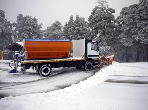
How to forecast extreme snowfall in Spain

February 6 2015, by Plataforma Sinc

Cotos pass in the Guadarrama mountain range during the exceptional snowfall on
4 March 2011 in the Madrid province (Spain). Credit: Estíbaliz Gascón

As of yesterday, the entire Iberian Peninsula and the Balearic Islands are
in the midst of the first significant cold snap for three winters. However,
intense snowfalls, like the one affecting the whole of the north of the
Peninsula and the Balearic Islands, are not as common in the rest of
Spain. A team of researchers has analysed the extreme snow that fell in

1/5

March 2011 in the province of Madrid in the hope that the results will
allow us to understand and forecast similar episodes in the future.

The snow warning issued on 3 March 2011 by the State Meteorological
Agency in Spain (AEMET) warned of drifts of up to 18 centimetres in
mountainous areas of Madrid and three centimetres in urban areas of the
province for the following day. However the forecasts were out by a long
shot. The severity of the snow storm that fell on the Madrid province
was unexpected.

On 4 March 2011, the exceptional amount of snow falling over 24 hours
meant up to 34 centimetres in the Guadarrama mountain range and up to
8 centimetres in metropolitan areas of the capital, "which caused
numerous problems on the main access roads to Madrid and power cuts,"
as Estíbaliz Gascón, researcher at the Atmospheric Physics Group of the
University of León tells SINC. The Directorate-General for Traffic
(DGT) recorded 30 kilometres of tailbacks on the A6 with delays of up
to five hours.

This week, the freak weather has been repeated in other areas of
northern Spain and the Balearic Islands, where the snow has fallen at sea
level and 200 metres respectively. In general, these extreme events are
less common in the majority of non-mountainous areas of the Iberian
Peninsula, but they can occur. It is predicted that the severe weather will
continue until at least Sunday and even until Tuesday 10 February.

Outside the region of Madrid "it is more common to find this kind of
heavy snowfall almost every year, due to the orographic conditions and
closeness to the sea. This is case of the Pyrenees and the Cantabrian
Mountains for example," explains Gascón. A mass of cold air from the
north or north-east coming off the Atlantic and loaded with moisture are
the 'ingredients' for a spell of intense snow in these areas.

2/5
According the researcher, the clouds do not usually pass over the
northern mountain ranges, "and so the precipitation stays there and does
not reach other areas inland". However, given the right conditions, these
intense precipitations reach the centre of the Peninsula.

The exceptional combination to generate snow

A heavy snowfall can be produced "if a mass of very moist and relatively
warm air hits the Peninsula (generally with a westerly or south-westerly
wind) and rises over a mass of very cold and dry air (like the dry
Siberian air mass), for several days," points out the researcher.

A study by Gascón, published in 'Atmospheric Research', demonstrates
with numerical models and the analysis of satellite images of the
Meteosat Second Generation Satellite that the heavy snowfall in Madrid
was produced by the convergence of two different air masses in the
centre of the Peninsula: one warmer and wetter low-level mass and
another colder and drier mass at medium to high levels.

"The cold air mass helps to cool the warm and wet mass, causing
significant precipitation at low levels," explains Gascón, lead author of
the study, who reiterates that this situation does not happen very
frequently in winter.

The researchers, who took data continuously during the snowfall in the
Lozoya reservoir (Guadarrama mountain range), precisely determined
the places most affected by the precipitation, as well as its duration. "A
two-hour period in which the precipitation was more intense was
identified, and convective cloud developments with significant vertical
velocities detected," adds Gascón.

Better forecasts, less chaos

3/5
By examining this episode scientists could locate the distribution of this
snowfall in space and time, an analysis that is "very important when it
comes to improving short and medium-term forecasts". According to the
researchers, their study will help to predict similar episodes in the future,
but "it is necessary to study many other cases of snowstorms to assess
whether the factors that affect their formation are the same," highlights
Gascón.

In another study published in the Journal of Geophysical Research:
Atmospheres, scientists have measured the evolution of variables such as
the content of liquid water, temperature, relative humidity and water
vapour "to improve short-term predictions".

Although there is a possibility that the Madrid snowfall in March 2011
will happen again, the chances "are low," warns the expert. In any case,
Gascón clarifies that the predictions from numerical models more than
two or three days into the future are "not very reliable". "We wouldn't
know if the episode was to be repeated until a few days beforehand," she
admits.

 More information: "Numerical diagnosis of a heavy snowfall event in
the center of the Iberian Peninsula" Atmospheric Research 153: 250-263
febrero de 2015 DOI: 10.1016/j.atmosres.2014.08.001

Provided by Plataforma SINC

Citation: How to forecast extreme snowfall in Spain (2015, February 6) retrieved 17 June 2024
from https://phys.org/news/2015-02-extreme-snowfall-spain.html

This document is subject to copyright. Apart from any fair dealing for the purpose of private
study or research, no part may be reproduced without the written permission. The content is

4/5
provided for information purposes only.

                                   5/5

Powered by TCPDF (www.tcpdf.org)
You can also read