HRWS: X-Band-SAR der nächsten Generation - Überblick und Anwendungspotentiale Markus Jochum, Jürgen Janoth Neue Perspektiven der Erdbeobachtung ...
←
→
Page content transcription
If your browser does not render page correctly, please read the page content below
HRWS: X-Band-SAR der nächsten Generation
Überblick und Anwendungspotentiale

Markus Jochum, Jürgen Janoth

Neue Perspektiven der Erdbeobachtung 25-27. Juni 2018, Köln
Die aktuelle Generation X-Band SAR (Zivil)

                                                              TerraSAR-X TanDEM-X
                                                                      seit 2007 / 2010

                                                                        Satellitenbau
                                                                        Service Segment
                                                                        exklusive kommerzielle Datennutzungsrechte
                                                                  &
                                                                        Eigentümer
                                                                        Satellitenbetrieb
                                                                        Exklusive wisseschaftliche Nutzungsrechte

2            Neue Perspektiven der Erdbeobachtung, 25-27 Juni, 2018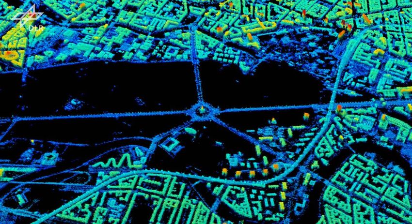
HRWS Mission Background

Mission Context and Status
     • Next National Civilian X-Band SAR Mission to continue the successful TerraSAR and TanDEM Missions
     • Partnership approach between DLR Space Administration and Industry
     • Phase 0/A Study contracted by DLR to Airbus
     • Mission Definition Review successfully passed May 2017
     • Preliminary Requirements Review June 2018
     • Launch envisaged for 2023

Main User Groups

    German Institutional users incl. Defence                          Science users   Commercial users

3                   Neue Perspektiven der Erdbeobachtung, 25-27 Juni, 2018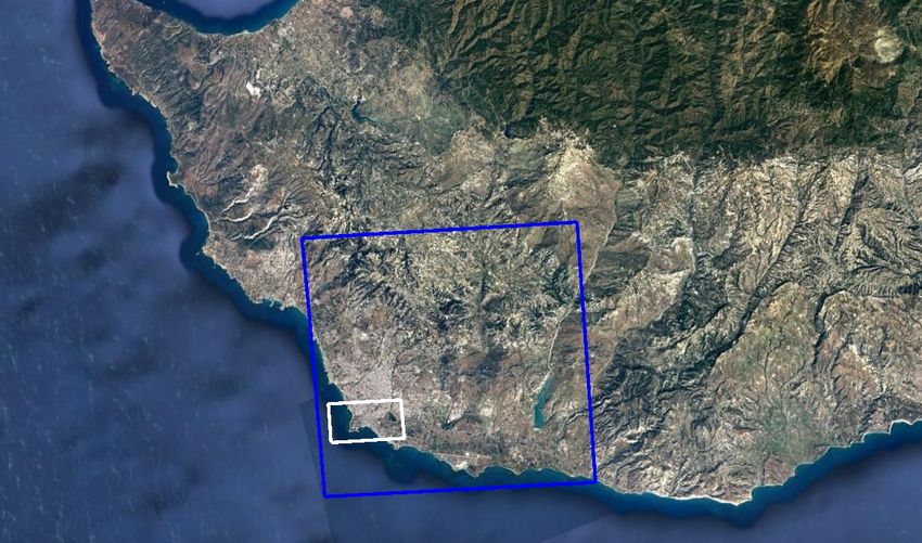
User Requirements
Result of a comprehensive User Survey

    Applications                                                      National             Science   Commercial   Delivery    Resolution     Swath
    Surface Movement                                                     X                    X         X         Standard     0,25-3 m     50-80 km
    Maritime / Ocean
    Ship detection Oil, Ice, Monitoring, Wind speed,                         X               X           X          NRT        3-40 m      100-600 km
    Ocean currents

    Change Detection                                                         X               X           X        Standard     0,25-3 m     25-80 km
    IMINT / GEOINT                                                                           X           X          NRT       0,25-0,5 m    15-25 km
    Image Intelligence

    Thematic Mapping
    Agriculture, Forestry, Environment, Urban, Land Use,                     X               X           X        Standard      1-3 m      45-100 km
    Flood, Permafrost, Glacier Monitoring

    DEM Generation
    Improved global DEM                                                                                                          1m
                                                                             X               X           X        On-demand                 45-60 km
    Regional updates                                                                                                             4m
    Local

    Multi-static Application                                                                                                     1m
                                                                           tbd               X           X        On-demand                 45-60 km
    Volumetric- and Height measurement                                                                                           4m

4                                 Neue Perspektiven der Erdbeobachtung, 25-27 Juni, 2018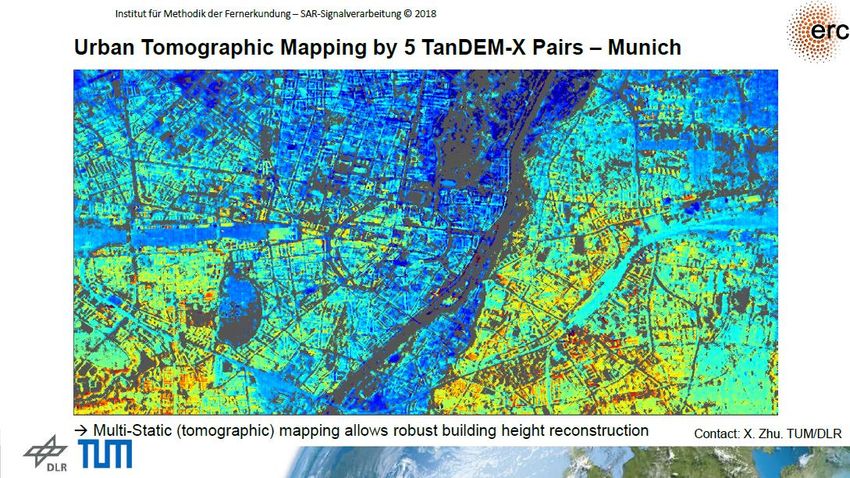
HRWS Mission Objectives

Programmatic and Strategic Objectives:
     • Fostering leading German capabilities in X-Band SAR technology
     • Ensuring high resolution X-Band data continuity from 2023 onwards
     • Continuation of successful EO-commercialisation

Main Scientific and Technical Objectives:
     • In-Orbit demonstration of innovative Digital Beam-Forming technologies
     • Utilization of the newly available chirp bandwidth of 1200 MHz
     • Formation flight capability to allow for an update/improvement of existing DEM
     • Implementation of new modes with improved coverage and high resolution

5                Neue Perspektiven der Erdbeobachtung, 25-27 Juni, 2018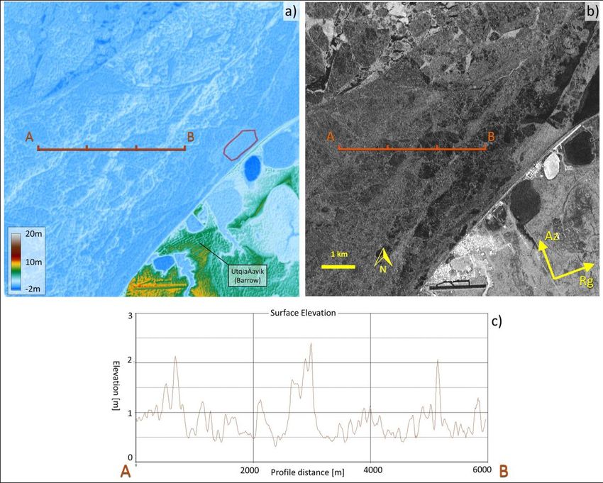
HRWS Technical Objectives
         In-Orbit demonstration of innovative Digital Beam-Forming Technologies

                    TerraSAR Generation                                           HRWS - High Resolution Wide Swath

       StripMap

           Medium resolution and image size                                 to…
        ScanSAR

        ScanSAR

           Low resolution & large image size                                                    Large Area Coverage
       Spotlight                                                                                 Excellent Resolution

        Very High resolution & very small images

                       High Resolution or                                               Very High Resolution and
                      Large Area Coverage                                                 Large Area Coverage

6                  Neue Perspektiven der Erdbeobachtung, 25-27 Juni, 2018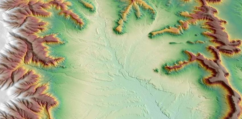
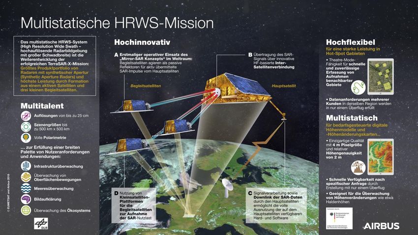
HRWS Study: From a one Satellite Mission towards a Multi-static Mission…

7           Neue Perspektiven der Erdbeobachtung, 25-27 Juni, 2018
HRWS Theatre Mode
Clustered distribution of areas of interest: System
limitation by conflict not by capacity
Solution:
Many high resolution Spotlight acquisitions in one
area of interest
TerraSAR-X Heat Map
Rapid switch between left and right looking
8 Neue Perspektiven der Erdbeobachtung, 25-27 Juni, 2018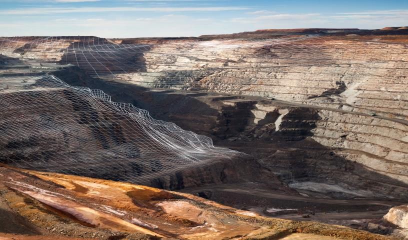
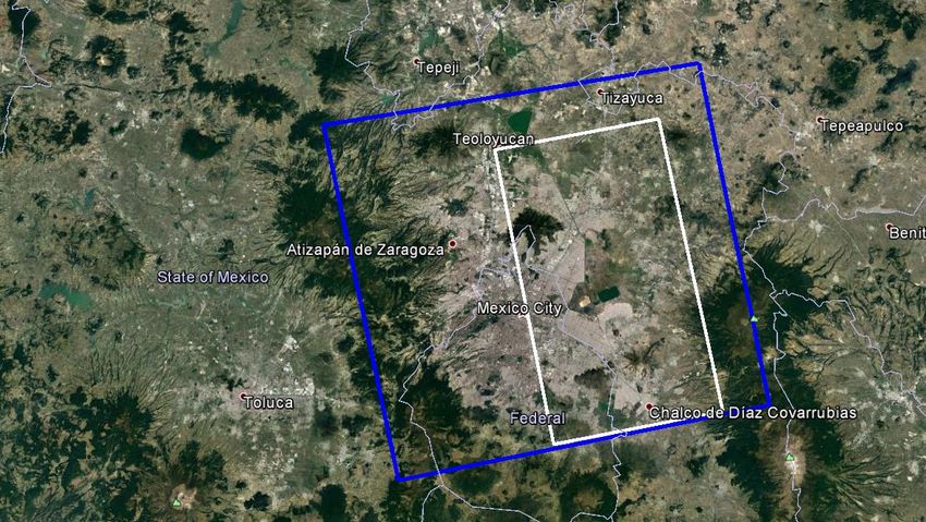
HRWS Selected Mode Examples

                                              Resolution                 Scene Size    Acc. Range
                                                                                                      Pol
                                               Rg x Az                     WxL         Near ... Far
       Staring SL
                                           0,25m x 0,25m                10km x 10km     30°...54°     SP
       „Theatre“

        Sliding SL                         0,25m x 0,25m                20km x >20km    30°...67°     SP

        Sliding SL                         0,25m x 0,25m                15km x >15km    30°...55°     QP

        Sliding SL                           0,5m x 0,5m                30km x >30km    20°...65°     SP

       Strip-Map                                1m x 1m                    50km        30° ... 61°    SP

       Strip-Map                                2m x 2m                    30km        20° ... 52°    QP

       Strip-Map                                3m x 3m                    80km        20° ... 53°    SP

        ScanSAR                                 2m x 8m                    120km       20° ... 44°    QP

        ScanSAR                                2m x 16m                    540km       20° ... 59°    SP

9              Neue Perspektiven der Erdbeobachtung, 25-27 Juni, 2018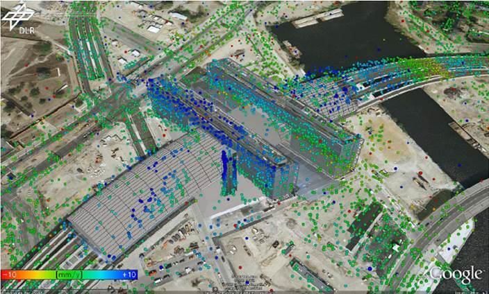
HRWS SAR Performance Examples

VHR SpotLight

10         Neue Perspektiven der Erdbeobachtung, 25-27 Juni, 2018
HRWS SAR Performance Examples

StripMap

11         Neue Perspektiven der Erdbeobachtung, 25-27 Juni, 2018
HRWS SAR Performance Examples

ScanSAR

12        Neue Perspektiven der Erdbeobachtung, 25-27 Juni, 2018
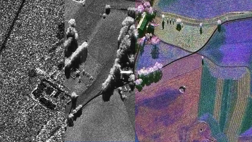
HRWS SAR Performance Examples – VHR SpotLight

     1 m | TerraSAR-X                                             25 cm | HRWS   Polarimetrie | HRWS

13                Neue Perspektiven der Erdbeobachtung, 25-27 Juni, 2018
HRWS Application Potential
Mono-static Capabilities:
• High Resolution Infrastructure Integrity Monitoring using Interferometry
• Large Area Maritime Surveillance (Vessel Detection)
• Target Recognition using Quad Polarimetry
• Improved NRT capabilities using Laser Communication Technology
Multi-static Capabilities:
• On-demand regional Digital Elevation Models
• 3D Re-construction using SAR Tomography
• 3D/4D Change Detection
• Sea Ice Topography
• Ground Moving Target Indication using Along Track Interferometry
14 Neue Perspektiven der Erdbeobachtung, 25-27 Juni, 2018HRWS Application Examples – Regional Digital Elevation Models
Regional Digital Elevation Models
• DEMs according to HRE 40 Standard
• Pixel Spacing: 4 m x 4m
• Relative Height Accuracy: < 2m
• On-demand ordering
• Acquisition and processing in short time
15 UK – Germany
Neue Research
Perspektiven & Technology Meeting,
der Erdbeobachtung, Unterlüß,
25-27 Juni, 2018 January 30th 2018Ergebnisse der DEM Performance Analysen | Mögliches Szenario
Hintergrund
• Bestellung eines aktuellen, hochauflösenden
regionalen Höhenmodells (HRE-40 Standard) von
Nigeria
Nigeria
Ziel
• Schnelle Akquisition, Prozessierung und 923.768 km2
Auslieferung
Datenquelle
• HRWS Multi-Static StripMap Daten
Lieferung
• HRWS „On-Demand“ Digital Elevation Model … sehr anspruchsvoll, da große Fläche (2.5 x
(HRE40 Standard) Fläche Deutschland) und nah am Äquator
16 Neue Perspektiven der Erdbeobachtung, 25-27 Juni, 2018Ergebnisse der DEM Performance Analysen | Mögliches Szenario
Anfrage für ein neues
HRWS Regional DEM
01. Juli 2026
17 Neue Perspektiven der Erdbeobachtung, 25-27 Juni, 2018Ergebnisse der DEM Performance Analysen | Mögliches Szenario
Anfrage für ein neues
HRWS Regional DEM
01. Juli 2026
Start der
Datenaufnahme
03. Juli 2026
18 Neue Perspektiven der Erdbeobachtung, 25-27 Juni, 2018Ergebnisse der DEM Performance Analysen | Mögliches Szenario
Anfrage für ein neues Beginn der Daten-
HRWS Regional DEM prozessierung
01. Juli 2026 01. Nov 2026
Start der
Datenaufnahme
03. Juli 2026
19 Neue Perspektiven der Erdbeobachtung, 25-27 Juni, 2018Ergebnisse der DEM Performance Analysen | Mögliches Szenario
Anfrage für ein neues Beginn der Daten-
HRWS Regional DEM prozessierung
01. Juli 2026 01. Nov 2026
Start der 1. Ende der Daten-
Datenaufnahme aufnahme
03. Juli 2026 15.Nov 2026
20 Neue Perspektiven der Erdbeobachtung, 25-27 Juni, 2018Ergebnisse der DEM Performance Analysen | Mögliches Szenario
Anfrage für ein neues Beginn der Daten- Lieferung des
HRWS Regional DEM prozessierung Geländemodells
01. Juli 2026 (HRE40)
01. Nov 2026
01. Dez 2026
Nigeria
Start der 1. Ende der Daten- Geländemodell
Datenaufnahme aufnahme (HRE40)
03. Juli 2026 15.Nov 2026
21 Neue Perspektiven der Erdbeobachtung, 25-27 Juni, 2018HRWS Multi-Static Application Examples – 3D/4D Change Detection
High resolution DSMs can be used for 3D Change Detection, e.g. for Stock-Pile Monitoring
Mineral Volume = DSMDate1 x Area,
Mineral Exported= Mineral Volume Date1 - Mineral Volume Date2
DInSAR
Horizontal
Baselines
R
x
2
2π
Phase
0
Rotterdam Europoort Rotterdam Europoort Rotterdam Europoort
Google-Earth TSX, HH, HS, 15/10/2014 DSM, 15/10/2014
InSAR Horizontal
Baselines
R R
x x
2 2
or Mine Monitoring
22 Neue Perspektiven der Erdbeobachtung, 25-27 Juni, 2018HRWS Multi-Static
Application
Examples
Sea-Ice Topography
Location: Pt. Barrow, Alaska
Acquisition: March 29, 2015
Publication: Effective Baseline = 1113 m
Height of Ambiguity = 7.4 m
Inc. Angle = 27.3°
Dierking, W., Lang, O., and Busche, T.: Sea Pixel size: 12 m
ice local surface topography from single- STD (z) = 0.12 m
pass satellite InSAR measurements: a
feasibility study, The Cryosphere Discuss.,
doi:10.5194/tc-2017-40, in review, 2017.
(http://www.the-cryosphere-discuss.net/tc-
2017-40/)
23 Neue Perspektiven der Erdbeobachtung, 25-27 Juni, 201824 Neue Perspektiven der Erdbeobachtung, 25-27 Juni, 2018
SAR Tomography of Berlin (Courtesy: DLR)

25           Neue Perspektiven der Erdbeobachtung, 25-27 Juni, 2018
WorldSAR – Current and Future Missions
HRWS (2023+)
incl. 3 companions
PAZ (2018) Export partner Small Sat Const.*
partner
TerraSAR-X (2007)
TanDEM-X (2010)
* Small Satellite SAR
WorldSAR Next Generation constellation concepts for
HRWS (1200 MHz, < 25 cm, mono- and multi- massive revisit
WorldSAR Constellation Operation static mission incl. 3 passive companions)
with Hisdesat (ES) Export partner
Small Satellite SAR Constellation
26 Neue Perspektiven der Erdbeobachtung, 25-27 Juni, 2018Acknowledgements
The HRWS Phase 0/A Study is kindly funded by the federal Ministry of Economics and Technology (BMWi) / DLR Space
Administration under the funding code 50 EE 1611.
Thank you!
Markus Jochum
Future SAR Program Manager
Airbus / Intelligence
markus.jochum@airbus.com
+49 7545 8 2086
27You can also read