Cross-sectoral planning of Green Infrastructure
←
→
Page content transcription
If your browser does not render page correctly, please read the page content below
SEE RIVER PROJECT

                                                               HAND IN HAND
                                                                  FOR RIVERS

                                                          WWW.SEE-RIVER.NET

       Dr. Aleš Bizjak, SEE River Project Manager

Cross-sectoral planning of Green Infrastructure –
   the River Corridor Development Concept

       Mediterranean Coast and EU Macro-Regional Strategies Week
       Škocjanski zatok Nature Reserve – Koper, 19 September 2017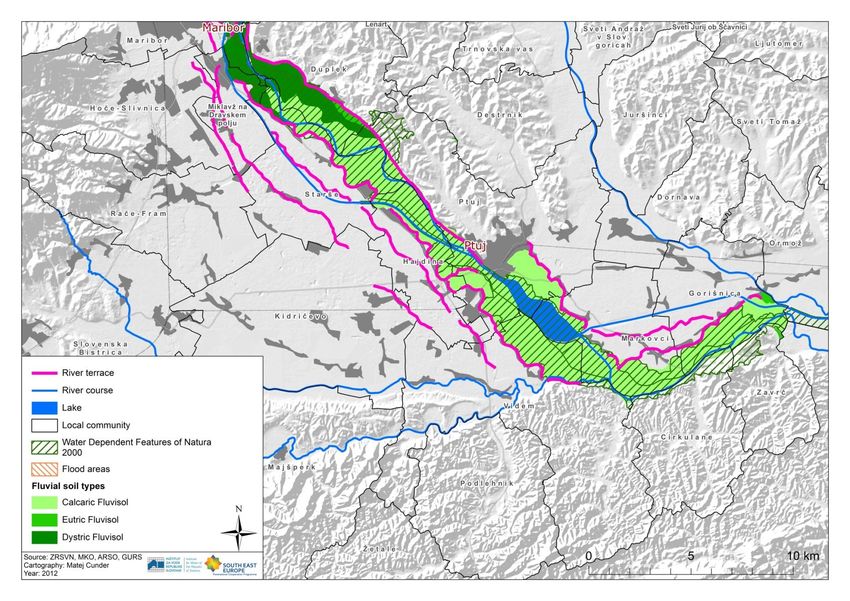
content

  1. Contemporary rivers as parts of green infrastructure
  2. SEE River project
  3. River Corridor Development Concept (RCDC)
(1)
contemporary rivers as parts of green infrastructure
premises – naturocentric view
1.   River is natural phenomenon, but never of a local
     scale.
2.   Intrinsicaly, to each river belongs a river corridor –
     an area along both river banks where
     hydromorphological processes take part as a
     limiting natural factor.
3.   River corridors are parts of landscape ecological
     structure (matrices, patches, mosaics, corridors)
     and have inner ecological structure (matrices,
     patches, mosaics, corridors) – therefore are parts
     of the green infrastructure.

                                                              Wells et al., 1998.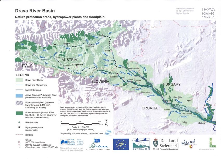
premises – antropocentric view
1.   Rivers as natural resource and river corridors as parts of land were always
     attractive for mankind for very different reasons, however always
     related to needs of survival, or in later phases, for economic benefit.
2.   Sustainable cross-sectoral planning of river corridors can be assured by a
     regional approach instead by a general (transboundary or national) or a
     fragmented (local) manner, where top-down meets bottom-up.
3.   Improper land use (planning) (policy) can cause sever damages to natural
     environment as well can endanger mankind lifes and harm state or
     private property.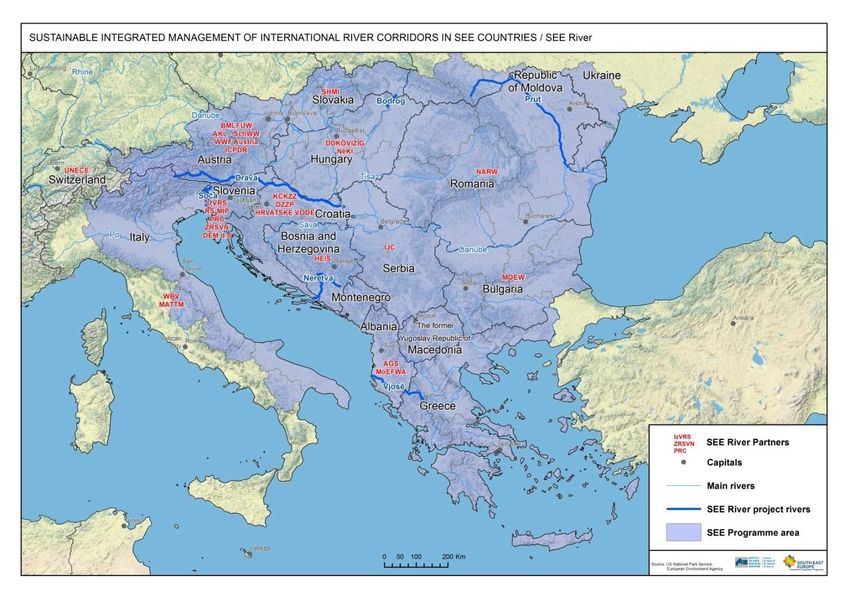
river corridor delineation
contemporary river
Sava River, View from Šmarna gora, Marko Perhart, about 1850. Sava River, View from Šmarna gora, photo: A. Bizjak, 2012.
Contemporary river is a river (corridor), managed in a way to accomplish
all (antagonistic) protective and developmental sectoral goals, initiatives
and measures as well as interests of riparian local communities. It possess
good water status, good habitat status and low flood risk.
A realistic or too ambitious goal?
Drava River Vision Declaration (Maribor, SI, 2008)
Drava River Vision Declaration (Maribor, SI, 2008)

                        Aim:
   Drava River will become a contemporary river.

                                               When?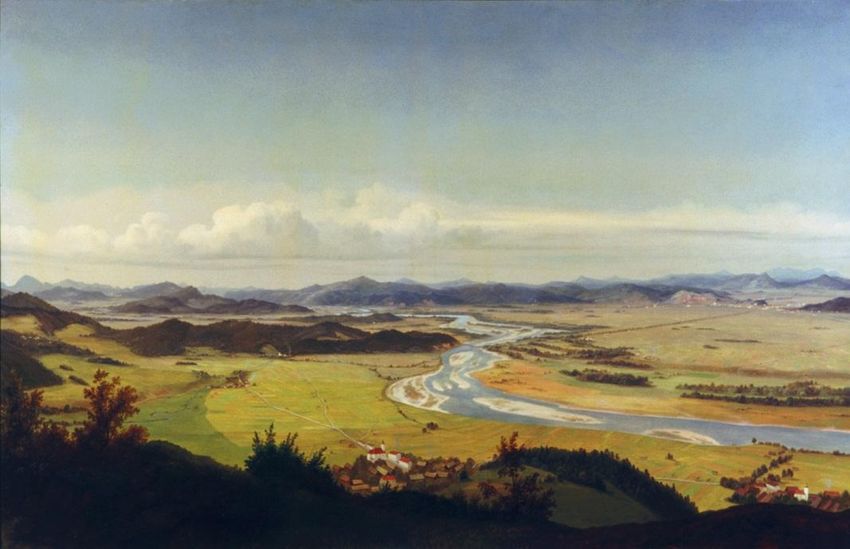
(2)
SEE River Project
SEE River PowerPoint Template
SEE River – basic information and partnership
THE PROJECT
project funded by the South East Europe
Territorial Cooperation Programme
lead Partner: Institute for Water of
Republic of Slovenia
project Partners: 26 from 11 countires (22
+4 international)
project duration: 1 October 2012 – 30
September 2014
total project value: 2,107,354.30 € (85%
co-financed by EU)
THE PARTNERSHIP
different sectors
different administrative levels
different types of organisations
partners from 5 Drava-riparian states
(IT, AT, SI, HR, HU)
partners, representing territories of 6
other rivers: Bodrog, Neretva, Prut,
Soča, Vjosa, Kolubara (SK, BiH, RO,
RS, AL)SEE River PowerPoint Template
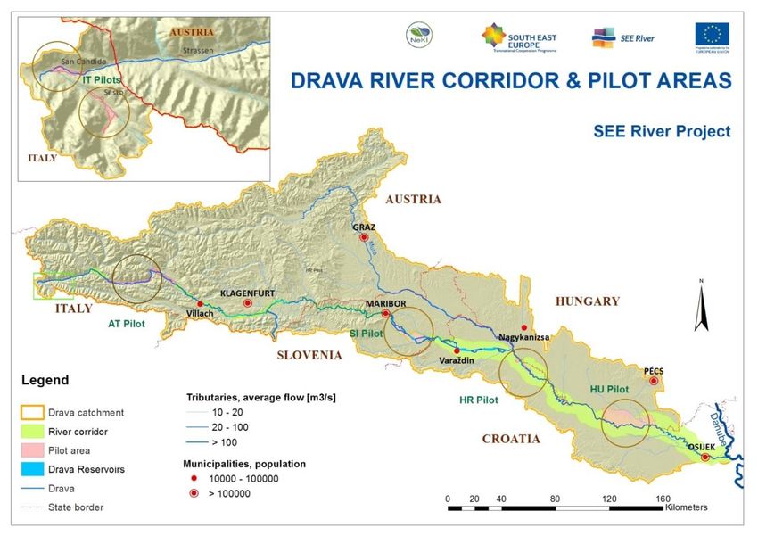
SEE River pilot transboundary rivers
I A SI CRO H
Drava
749 km (I, A, SI, CRO, H)
Soča
138 km (SI, I)
Neretva
230 km (BiH, CRO)
Bodrog
67 km (UI, SK, H)
Prut
953 km (UI, MD, RO)
Vjosha
272 km (GR, ALB)
Kolubara
123 km (RS)SEE River pilot transboundary rivers Drava Bodrog Neretva Prut Soča Vjosa
selection of the 5 Drava River pilot areas

   relevant (involved)    Fiscalina & Drava (I)
                            (1+4 km; 1,6+1,7
                                                       Drau (A)          Drava (SI)       Drava (HR)          Drava (H)
                                                  (80 km; 247 km²)   (47 km; 160 km²)   (29 km; 33 km²)   (62 km; 347 km²)
   sectors                        km²)

   water management                x                     x                  x                 x                  x
   nature conservation             x                     x                  x                 x                  x
   forestry                        x                                                          x                  x
   agriculture                     x                     x                  x                                    x
   tourism & recreation            x                     x                  x                 x                  x
   transport                       x                     x
   hydropower                                            x                  x                 x
   mining                                                                                     x
   navigation                                                               x                                    x
   fishing                                                                  x                                    x
SEE River elaboration levels on the Drava River
1) Drava river pilot areas (5).
2) Drava River International run.
WHERE TO APPLY?
I A SI HR Hproject result Result of the SEE River project are adopted new knowledges, processes and procedures of harmonising sectoral policies, plans and programmes with interests of stakeholders from international, national, regional, and local levels and of riparian local communities in the process of (international) river corridor management.
(3)
the river corridor development concept
What is river corridor development concept? cross-sectorally reconciled development action plan on a regional scale, based on torough analysis of natural circumstances and stakeholders views and expectations based on sustainable development and watercentric issues, and on the idea more room for the rivers, compiles sectoral initiatives and seeks for multifunctional spatial solutions, respects the relevant EU directives, national, regional and local legal demands, Involves stakeholders form national, regional and local level and articulates their demands and initiatives.
river corridor development concept goals
(1) To ensure sustainable use of natural resources.

(2) To improve the sate of environment and living conditions in the
area.

(3) To decrease the level of environmental risks.

(4) To utilise the spatial atractiveness of the region.

(5) To engage the financial sources in a rational way.

(6) To increase the economic competiveness and employability in the
region.
issues water management, nature protection, utilisation of sustainable energy sources, forestry and agriculture, tourism and recreation, traffic, other relevant sectors, present in the area.
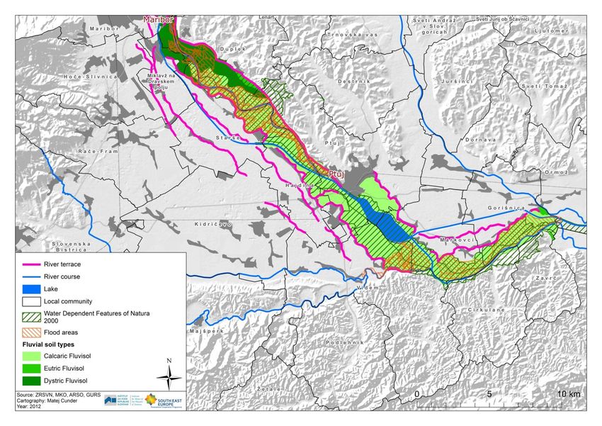
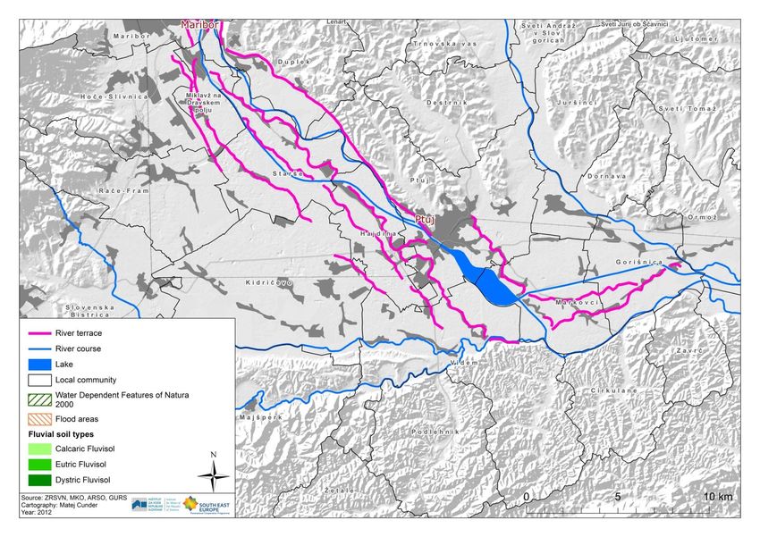
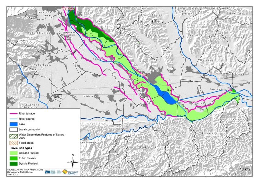
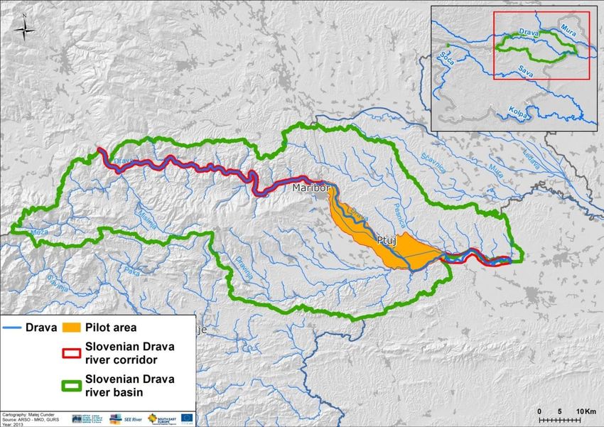
river section length: 46 km1
The SI Drava Pilot Area area surface:160 km2
point sources of pollution
diffuse sources of pollution
HYMO pressures
CC impacts
densely populated areas
infrastructure and property
flood risk (casualties, damages)The SI Drava Pilot Area
local community surface total surface within RC surface portion within RC
km2 km2 %
Cirkulane 32,1 0,7 2,2
Dornava 28,4 4,3 15,1
Duplek 40,0 9,2 22,9
Gorišnica 29,1 19,2 65,8
Hajdina 21,8 15,0 68,8
Hoče-Slivnica 53,7 < 0,1 < 0,1
Kidričevo 71,5 2,0 2,8
Maribor 147,5 9,6 6,5
Markovci 29,8 29,8 100,0
Miklavž na Dravskem polju 12,5 8,3 66,2
Ormož 141,6 < 0,1 < 0,1
Ptuj 66,7 25,5 38,2
Starše 34,0 25,0 73,5
Videm 80,0 11,3 14,1
Zavrč 19,3 0,3 1,5
SKUPAJ 807,9 160,1SEE River PowerPoint Template
Life Vein – Obere Drau
DRV Declaration (2008)
(LIFE+, 2006-2011) goals ‚10‘ the algorithm
determination of river corridor
national level
of planning local level
analysis of river corridor of planning
international and bialteral regional development plans
obligations status remoteness from goals
local communities spatial development plans
state infrastructure projects ‚10‘ stakeholder involvement and participation
RBMP interviews and questionnaries
FRMP management regimes etc.
NATURA 2000 management plans
NREAP
and adminstrative procedures
list of stakeholders regional level of planning list of stakeholders
record of demands, top-down bottom-up record of demands,
expectations and expectations and
initiatives initiatives
analysis of analisys of
oppositions oppositions
reconciled goals and solutions
feed-back effect river corridor development concept
feed-back effect
action plan and project proposals
(e.g. for the EU 2014-2020)experts
phitocoenosis soils hydrology hydromorphology
natural variables and resources analyses
experts
Drava 2030 Natura 2000 RCIR
experts and stakeholders
cross sectoral cooperation and
stakeholder dialogue scheme regimes
structure of the elaboration process
sectoral development interests
experts and stakeholders
river corridor development scheme
environmental hot-spots analysis
and action planRiver Corridor Development Concept Scheme
What are the local intitatives?

What are the national interests?      What should the (Drava) River look like in 2030?

Mapping the stakeholders interests.               Mapping the stakeholders interests.
Drava River Corridor Action Plan
1. Water-nature protection-hydropower utilisation managment
and use of the Drava River: (1) Drava River Corridor
Restoration – integrated flood protection development and habitat
diverstity protection project.
2. Good Forestry and Agricultural Practices on flooded and
ground water areas in the river Drava River Corridor: (1) The
Šturmovci area restoration project.
3. Recreational and touristic water way Maribor – Ptuj – Zavrč:
(1) The Drava River bike lane, (2) The Drava River navigation
way, (3) Fishes and Fisheries.
4. Education and awareness raising: (1) Establishment of
regional information centre on Mariborski otok.
Who does what when structure.
Description of the action (background, purpose, activites).
Expected synergies.
Financing possibilities.good practices 1. Entwicklungskonzept Alpenrheim (IRKA, 2005). 2. River Basin Agenda for Alpine Space (BSUGV, 2006). 3. Gewässerentwicklungskonzept Gurk (BLFUW, AKL; 2009). 4. Future Water (DEFRA HM Government, 2008). 5. Water for People and the Environment (Environment Agency, 2009).
content

  1. River corridors as parts of green infrastructure
  2. SEE River project
  3. River Corridor Development Concept (RCDC)
Almost everyone has an exceedingly inconsistent
perception of reality. The only things they find real are
the things that represent their interests. They find
everything else, which is by all means just as real,
abstract.

(Stephen Spender, English poet, 1909 – 1995)
Thank you for your attention!
         WWW.SEE-RIVER.NET

               Aleš Bizjak
        Slovenian Water Agency
           ales.bizjak@gov.si
You can also read