Reality Modeling Best Practices Guide Photogrammetry and Laser Scan Acquisitions - Image Courtesy of University of Cambridge and Topcon - Bentley ...
←
→
Page content transcription
If your browser does not render page correctly, please read the page content below
Reality Modeling Best Practices Guide
Photogrammetry and Laser Scan Acquisitions
                       Image Courtesy of University of Cambridge and Topcon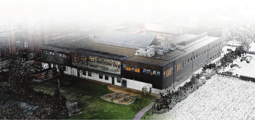
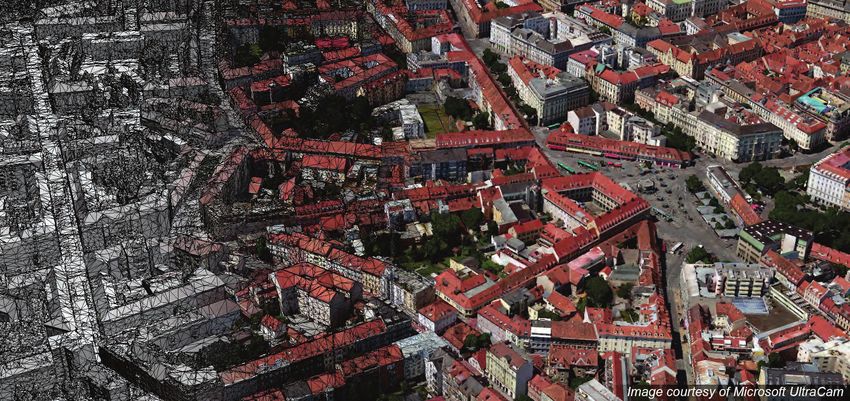
Introduction
Reconstructing indoor or outdoor scenes with drone technology and laser scanners can be tricky
and time consuming. And, when the scene combines both indoor and outdoor settings, it’s even
more difficult. To understand what steps are involved and the best practices that should be
implemented, the University of Cambridge campus project in the U.K. is a prime example of how
you can achieve the right image acquisition using innovative technology. Through this example,
you will learn how to generate highly accurate 3D reality meshes with ContextCapture when
capturing a scene that combines both indoor and outdoor imagery.

The project and technology selected
The University of Cambridge campus project consisted of a 3D reality mesh production of the
primary site outdoor area of the campus, and the indoor and outdoor areas of the Institute for
manufacturing building located on the campus.
The campus’ primary site is approximately 556,000 square meters, and the Institute for
Manufacturing (IFM) building is about 5,300 square meters. The required accuracy of the 3D
reality mesh was 2 centimeters for the main site and 5 millimeters for the building.
Generating a 3D model using only drone-captured images and ground photos wouldn’t be
sufficient as the project required indoor capture and a high accuracy rate. A full hybrid
combination, including laser scans, drone image capture, and ground photography were selected
to meet project requirements.

2020 COPYRIGHT BENTLEY SYSTEMS, INCORPORATED                                                 1
STEP 1: Mission planning from the office

A critical step for acquiring the appropriate 3D reality mesh is to plan accordingly. Be sure to
analyze the project so that you know how to proceed. For example, on this project the team
needed to define the site capture process, the necessary overlap between images, and the
amount of equipment and staff to successfully complete the project. Specifically, this is what
should be done before beginning your image capture:

   •   Define the size of the area.
   •   Identify where the drone, handheld camera, and laser scans will be used.
   •   Define the take-off and landing areas, and be sure to obtain flight clearances.
   •   Determine how to access the main site and the building that you want to capture.
   •   Determine the drone flight path and the ground control points (GCPs) for the global area.
           o Choose the hardware
           o Define the flight height while considering an expectancy of 2-centimeter accuracy.
   •   Estimate the time it will take to conduct the image capture and the amount of personnel
       and equipment you will need.

The University of Cambridge campus project was split into two parts.

   •   The main site (outdoor)
   •   The IFM building (indoor and outdoor)

2020 COPYRIGHT BENTLEY SYSTEMS, INCORPORATED                                                   2
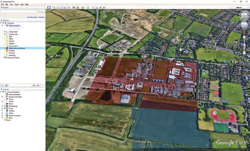
Main site

 Area                                                   556,000 square meters
 Expected accuracy                                      2 centimeters
 Flight plan                                            Oblique + Nadir Grid
 Number of pictures                                     4,500
 Estimated capture time                                 2 hours
 Equipment and staff                                    2 operators
                                                        1 Topcon Sirius Pro drone
                                                        1 Topcon Falcon 8 drone
                                                        1 camera
                                                        1 station

Single building

 Area                                                   5,300 square meters
 Expected accuracy                                      < 0.5 centimeters
 Number of pictures – outdoor drone + terrestrial       1,855
 Number of pictures – indoor                            1,335
 Number of scan stations – indoor                       15
 Estimated capture time                                 Outdoor: 4 hours
                                                        Indoor: estimated at 4 hours

STEP 2: On-site review

Once you have completed mission planning, go on site and determine that what has been
recommended during the planning stage is feasible. Be sure to take your time during the on-site
visit to plan in detail each photo and laser scan acquisition, so that you can identify potential
obstacles.

   •   Main site
          o Check the UAV take-off
          o Check the UAV landing area
          o Check for potential obstacles
          o Set the GCPs

                                                              Take-off and landing area

2020 COPYRIGHT BENTLEY SYSTEMS, INCORPORATED                                                    3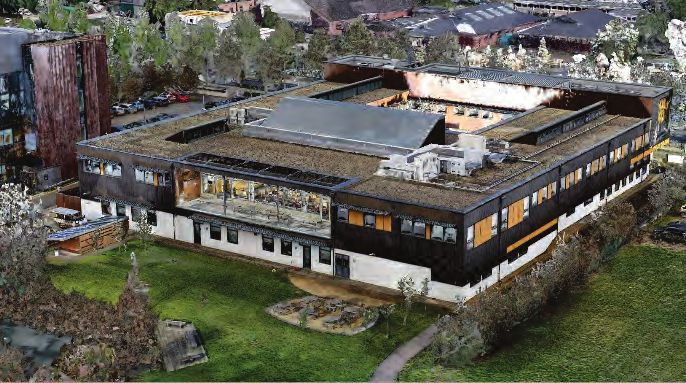
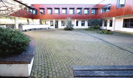
• Single building image capture – Outdoors
o First building site visit
o Define exact capture path
o Identify potential difficulties
o Test camera settings
Single building image capture - Outdoors
• Single building image capture – Indoors
o First indoor site visit
o Define exact capture path
o Identify potential difficulties
Shiny surfaces
Angles
Entrances
Single building image capture - Indoors
• Single building laser scan capture – Indoors
o Define scanner positions to
cover the entire area
o Make sure laser scanning activity
will not interfere with imagery
capture
Single building laser scan capture
On the University of Cambridge campus project, the reality modeling team checked everything
in advance. The team also determined that mission planning was feasible before performing
the on-site capture of the site.
2020 COPYRIGHT BENTLEY SYSTEMS, INCORPORATED 4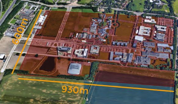
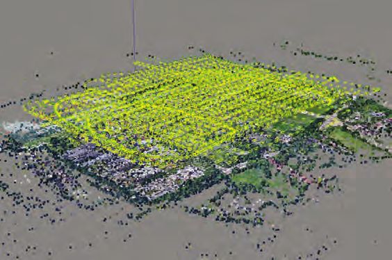
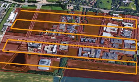
STEP 3: Capture

The following steps outline how the University of Cambridge campus was captured using
photogrammetry technology.

   •   Main site
The project team captured the main site at Cambridge using a Topcon Sirius Pro drone and a
Topcon Falcon 8 drone. The team took about 4,500 images while following a grid pattern and
oblique circles around the campus.
The team executed a predefined flight plan and set the GCPs before sending the UAV into the
air, flying at a constant height.

   •   Single building image capture – Outdoors
When capturing the outside of a building, the team followed the main capture path and closed the loop
to be sure they captured everything. Once the team acquired the images, it verified that the photo
capture was robust and without breaks by scrolling through the images.

   •   Single building image capture – Indoors
Indoor photo capture on the University of Cambridge project was tricky. Since the building has many
corners, the team had to ensure that the overlap requirements were met. The team also had to pay
attention to light condition changes and how they can affect images shot in automatic mode. As in the
outdoor capture, it’s strongly recommended to follow the main capture path and close the loop. To
ensure automatic stitching with the outdoor section, consider how the outdoor images match with the
indoor images and take extra care when capturing entrances.

2020 COPYRIGHT BENTLEY SYSTEMS, INCORPORATED                                                            5
•   Single building laser scan capture – Indoors
Lastly, set up the laser scan. First, identify the laser scan positions, then set up the laser scan
machines accordingly before acquisition starts.

STEP 4: Processing

Once completed, the photos and laser scans taken at University of Cambridge campus were
imported into ContextCapture to generate the 3D model.
Here are some processing tips to save time and increase efficiency:

   •   First, import the laser scans.
   •   Second, import and align the captured images on GCPs.
   •   Third, align the ground images with the indoor images and fit them to point clouds.
   •   Lastly, start the 3D reconstruction.

2020 COPYRIGHT BENTLEY SYSTEMS, INCORPORATED                                                          6
STEP 5: Mission closure

After the project team generated the 3D reality mesh of the Cambridge University campus, a
review of the different steps helped determine the time and associated costs needed for
planning further missions.
Below, in detail, is the time spent to generate the 3D reality mesh of the University of
Cambridge campus.

 Processing Stage                                                  Processing time
                                   1 - Planning                    1 hour
 Capture                           2 - Building tour               30 minutes
                                   3 - Image shooting              2-to-4 hours
                                   4 - Laser scan shooting         4 hours
 Processing                        1 - Manual processing           1 hour
                                   2 – Automatic processing        6days and 1hour
 Summary                           Project analysis                20 minutes
 TOTAL                                                           6 days 13 hours and 50minutes

2020 COPYRIGHT BENTLEY SYSTEMS, INCORPORATED                                                     7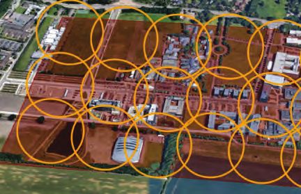
About ContextCapture
 ContextCapture is Bentley’s reality modeling software that can quickly produce 3D models
 of existing conditions for infrastructure projects of all types, derived from simple photographs
 and/or point cloud. Without the need for expensive or specialized equipment, ContextCapture
 enables users to quickly create and use these highly detailed 3D engineering-ready reality
 meshes to provide precise real-world context for design, construction, and operations decisions
 throughout the lifecycle of projects. Project teams can easily and consistently share reality
 modeling information, consumable and accessible, on desktop and mobile devices, in many
 formats, including native use within MicroStation for any engineering, operations, maintenance,
 or GIS workflow.
 For additional information, visit www.bentley.com/ContextCapture

 © 2020 Bentley Systems, Incorporated. Bentley, the Bentley logo, ContextCapture, ProjectWise, AssetWise, SYNCHRO, and MicroStation are
 either registered or unregistered trademarks or service marks of Bentley Systems, Incorporated or one of its direct or indirect wholly owned
 subsidiaries. Other brands and product names are trademarks of their respective owners. 03/20

2020 COPYRIGHT BENTLEY SYSTEMS, INCORPORATED                                                                                                    8
You can also read