Ice Age Ohio - Ohio Geological Survey
←
→
Page content transcription
If your browser does not render page correctly, please read the page content below
INTRODUCTION
                                   The Pleistocene Epoch, commonly referred
                              to as the Ice Age, is a small segment of geologic
                              time spanning the last 2.6 million years of the

Ice Age
                              Quaternary Period. The Pleistocene Epoch ended
                              about 11,600 years ago, which was the beginning
                              of the Holocene or Recent Epoch. The sediments
                              deposited by or in association with Pleistocene
                              glaciers represent the first well-documented

   Ohio
                              deposits in Ohio since the early Permian Period,
                              about 280 million years ago. This gap in Ohio’s
                              rock record is the result of a long period of erosion
                              and nondeposition from the late Permian through
                              the Neogene Period. Despite the comparatively
 BY MICHAEL C. HANSEN         short length of the Pleistocene, it has been one
                              of the most influential geologic episodes in the
                              cultural and economic development of Ohio.
                              Sediments deposited during the Pleistocene,
                              especially in the latter portion of this epoch,
                              cover all but the southeastern third of the state
                              and have been only slightly modified by erosion
                              since melting of the last glacier. These sediments
                              constitute the rich agricultural soils of Ohio;
                              furnish raw materials, such as clay, sand, and
                              gravel, for construction; and form extensive
                              aquifers for groundwater. Pleistocene deposits are
                              environmentally important as sites for landfills,
                              as source material for some landslides, and as a
                              medium that enhances ground motion during
                              earthquakes. The configuration of the glaciated
                              landscape has directly influenced settlement and
                              development patterns across the state.
                                   The Pleistocene Epoch began when the
                              climate cooled and ice and snow accumulated in
                              northern Canada to a depth sufficient enough to
                              form a great ice sheet that spread outward under
                              its own weight. Eventually the ice pushed into
                              the northern United States. Geologists estimate
                              that the ice may have been a mile thick in the Erie
                              basin and 1,000 feet thick in the central part of
                              Ohio. The buildup, spread, and melting of an ice
                              sheet occurred several times during the Pleistocene
                              Epoch. Each glaciation was followed by an interval
                              of warmer climate known as an interglaciation.
                                   The cause of the climatic fluctuations of
  Educational Leaflet No. 7   the Pleistocene that led to the development of
    Revised
    Revised Edition
            Edition 2020
                    2019      huge continental glaciers is poorly understood,
                              and scientists have advanced many hypotheses
                              to explain these perturbations. It is probable
                              that glaciations result from natural, long-term
                              variations in the amount of solar radiation that
                              reaches Earth’s surface, especially in the northern
                              hemisphere. Three factors—the tilt of Earth’s axis,
                              its wobble, and its path around the Sun—all vary
slightly, yet periodically, through time in what are called Milankovitch cycles. When the cycles of these three factors coincide
to give the northern hemisphere less than average solar radiation, Earth’s climate becomes cooler and glaciation eventually results.
      The earliest series of ice advances in North America were formerly referred to as the Nebraskan and Kansan Stages,
but now are referred to as pre-Illinoian glaciations. These advances are named for the states where their deposits were
first studied and described. Early glaciers greatly disrupted drainage patterns and modified the landscape; however, their
deposits are poorly known in Ohio. Deeply weathered pre-Illinoian glacial deposits have been recognized in southwestern
Ohio near Cincinnati and in a few isolated exposures in northeastern Ohio.
      Following a relatively warm interglaciation, perhaps warmer than our present climate, ice of the Illinoian glaciation
advanced far into Ohio, reaching into northern Kentucky. This event began about 300,000 years ago. The Illinoian ice caused
further drainage modifications and left distinctive morainic deposits extending from southwestern to north-central Ohio and
into northeastern Ohio. Outwash deposits presumed to be of Illinoian age are preserved as high terraces along the valley
walls of major rivers, such as the Hocking, Great and Little Miami, Muskingum, Ohio, and Scioto.
      After a long period known as the Sangamon Interglacial, which featured extensive weathering of Illinoian glacial
deposits, the Wisconsinan ice sheet began to form in Canada about 70,000 years ago. However, radiocarbon dates suggest
that Wisconsinan ice did not reach northern Ohio until about 24,000 years ago. The Wisconsinan glaciation (and probably
also the earlier glaciations) was marked by several major fluctuations of the ice margin. Wisconsinan glacial deposits blanket
the surface throughout the northern, central, and western portions of the state. The last of the ice was gone from Ohio by
about 14,000 years ago. Wisconsinan deposits are well preserved because of the relatively short interval of erosion and
weathering since their deposition. Events that occurred during the last 50,000 years, including much of the Wisconsinan, can
be accurately dated by measuring the amount of radioactive carbon (C14) in organic material, such as wood, shell, and bone
collected from glacial deposits. The glacial map shows the types and distribution of these deposits in Ohio.
      Changes to the Ohio landscape wrought by the ice sheets have greatly influenced our modern culture and economy.
Some of the major modifications are presented herein.

                                                DRAINAGE CHANGES
      Prior to glaciation, the western and southern portions of Ohio were drained by a major river system known as the Teays,
which had its headwaters in the Appalachian highlands of North Carolina and Virginia. The northeastern third of Ohio was
drained by the Erigan River, which flowed northeasterly through the basins now occupied by Lake Erie and Lake Ontario.
                                                                From its source, the Teays River flowed northwestward across
                                                                West Virginia and entered Ohio near Portsmouth. The Teays
                                                                River took a northward route across southern Ohio and, in a
                                                                classic interpretation, swung westward across central Ohio
                                                                into Indiana. Continuing its westward path across Indiana and
                                                                Illinois, the Teays eventually joined the ancestral Mississippi
                                                                River in western Illinois. Some geologists suggest that the
                                                                deep, buried valley in western Ohio represents an ice-front
                                                                stream formed in association with the earliest glacier and that
                                                                the Teays River actually continued northward and joined
                                                                the Erigan River. Multiple glaciations have greatly eroded and
                                                                deeply buried these river valleys, making interpretations difficult.
                                                                     Arrival of the earliest pre-Illinoian glacier blocked
                                                                the northwestward-flowing Teays River and its numerous
                                                                tributaries, creating a 7,000-square-mile lake in southern Ohio
                                                                and adjacent parts of Kentucky and West Virginia. Named
Preglacial Teays River in north-central U.S.                    Lake Tight, after William G. Tight, a geologist who first studied
                                                                the Teays River, this lake was partially filled with lake clays,
called the Minford clay, which are believed to be pre-Illinoian. The lake eventually spilled over low drainage divides and
established new drainage systems. These new drainage channels cut below the elevation of the Teays, forming a drainage
system known as Deep Stage. The modern Ohio River was formed as a result of these complex drainage changes
      Abundant evidence of drainage changes can be seen in Ohio. In the glaciated portion of the state, the old Teays
River system is represented by deep valleys cut into the bedrock. Today, the valleys are filled with glacial sediments. In
unglaciated southern Ohio, the Teays River valley and the valleys of its tributaries can be seen as broad flat valleys at an
elevation higher than that of modern stream valleys.

THE ICE AGE IN OHIO                                                                                                               2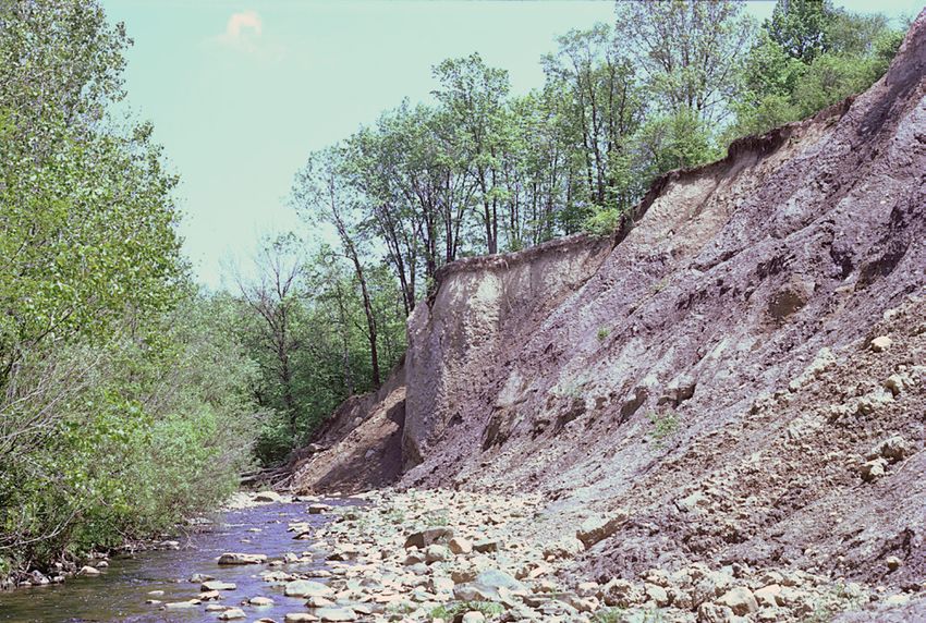
WISCONSINAN
                                                      (14,000 to 24,000 years old)
                                     Cuyahoga               Ground moraine

       ERIE LOBE                        lobe                Wave-planed ground moraine
                                             Grand
                                                            Ridge moraine
                               Killbuck       River
                                lobe          lobe            ILLINOIAN
                                                      (130,00 to 300,000 years old)

                                                            Ground moraine

                                                            Dissected ground moraine

                                                            Hummocky moraine

                      Scioto                                PRE-ILLINOIAN
                                                       (older than 300,000 years)
  Miami
                       lobe                                 Ground moraine
  lobe
                                                            Dissected ground moraine

                                                            Kames and eskers

                                                            Outwash

                                                            Lake deposits

                                                            Peat

                                                            Colluvium

THE ICE AGE IN OHIO                                                                      3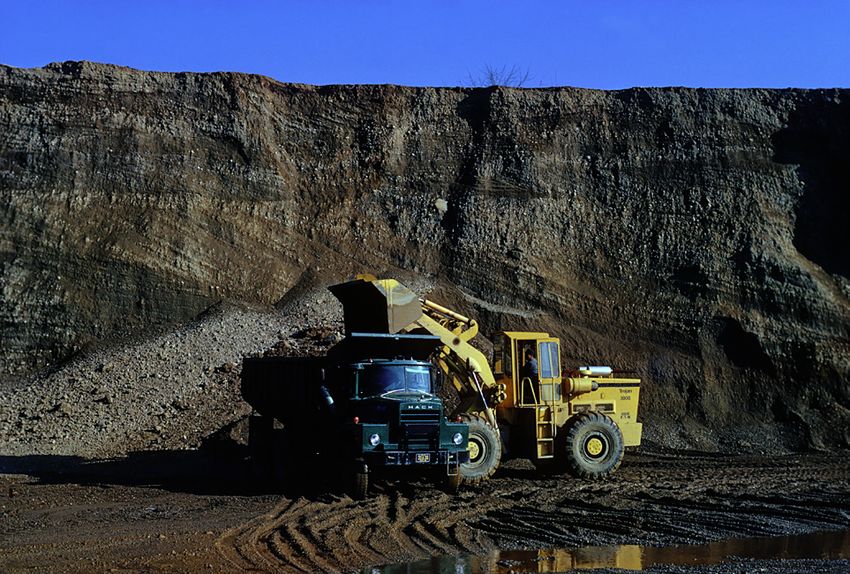
These intricately gouged and polished grooves in the Devonian‑age Columbus          Exposure of till, an unsorted glacial sediment that is a mixture of rock fragments
Limestone on Kelleys Island in Lake Erie are among the largest and best-preserved   ranging from clay size to boulders. Till represents material scraped up by the
glacial grooves in the world. The grooves likely were cut by subglacial meltwater   ice during its southward advance and deposited beneath advancing ice or as
and rocks frozen in the base of the mile‑thick Wisconsinan ice as it advanced       a sediment blanket when the ice melted. Multiple Wisconsinan‑age till beds,
across the Erie basin about 20,000 years ago. These grooves were designated         representing several ice advances and retreats, are visible in this exposure
as a National Natural Landmark in 1967 and are maintained as a State Memorial       along Rocky Fork Creek, near Gahanna, Franklin County. Glacial erratics, many
site by the Ohio History Connection.                                                of Canadian origin, have been eroded from the till and litter the stream bed.

                                                                    GLACIAL DEPOSITS
      The sediments left behind by ice sheets and meltwater are referred to as glacial drift and consist of boulders, cobbles,
sand, silt, and clay that had been gouged and scraped from the landscapes across which the ice moved. Drift deposits can be
classified according to their mode of origin, the materials of which they are composed, or the landforms which they created.
      An unsorted glacial sediment composed of materials ranging in size from boulders to clay and deposited directly by
ice is called till. Till is deposited directly at the bottom of
advancing ice or by the melting of stagnant ice. Till that
forms a fairly flat blanket over bedrock or older sediments
is called ground moraine. Where the ice-sheet halted for a
period of time, a thick, linear ridge of till was deposited along
the ice edge. Such ridges are called end moraines. The wide
distribution of end-moraine belts in Ohio is evident on the
map of glacial deposits. Morainic deposits commonly contain
boulders, some weighing many tons, that were carried by the
ice from as far away as Canada. These boulders of crystalline
igneous and metamorphic rocks, called erratics, are a familiar
sight in glaciated portions of Ohio.
      Kames and eskers, another major group of glacial
deposits, formed in contact with ice and running water.
Kames are hummocky mounds of stratified (layered) sand
and gravel deposited by meltwater flowing across the ice and
pouring its sediment load into holes and crevasses (crevices)
along the ice margin or in stagnant ice. Kames are numerous
in some portions of Ohio.
      Eskers are ridges of stratified sand and gravel deposited
on, within, or beneath the ice by meltwater rivers flowing
on the ice surface or under hydrostatic pressure in pipelike
tunnels. When the ice melted, the long, linear or sinuous
deposits were left behind, marking the courses of the former
channels or tunnels. Eskers, which are commonly oriented
parallel to the direction of last ice movement, may be found
in several areas of Ohio.                                         Landscape during maximum advance (top) and after (bottom) retreat of ice.

THE ICE AGE IN OHIO                                                                                                                                                4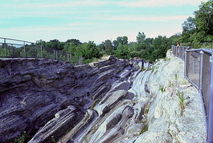
Stage’s Pond, one of many lakes left behind by the retreating Wisconsinan ice        Highest Lake Maumee (Maumee I) stage in the Erie basin. Drainage was westward
sheet. Stage’s Pond, near Ashville in Pickaway County, is a state nature preserve.   across Indiana into the Wabash River system. Modified from Hough (1958).

     As the huge ice sheets melted, great volumes of meltwater flowed in the river valleys, carrying with it, far beyond the
glacial border, large amounts of sediment that had been scraped up by the glacier on its long journey from Canada. This
sediment, termed outwash, consists mostly of sand and gravel, and it filled the valleys of such rivers as the Hocking, Great
and Little Miami, Muskingum, Ohio, and Scioto. These sand-and-gravel deposits are an important economic resource for the
construction industry and benefit areas of the state that are beyond the southern limit of glaciation. Outwash deposits also
are a major source of groundwater.
     Deposits of layered silt and clay accumulated in lakes in basins or in valleys whose outlets were dammed by glacial
ice or glacial deposits. Lake deposits commonly are preserved as terraces along valley walls where the modern stream has
eroded the lake deposits in the center of the valley. Other lake deposits are found in shallow basins between moraines,
which acted as barriers to drainage. Small ponds and lakes, known as kettles, formed in association with moraines when
blocks of ice became detached from the glacier and were buried by sediment. When the ice melted, a water-filled depression
was formed. Commonly, kettles contain deposits of calcareous marl which are overlain by peat. Many of these kettles have
become filled with sediment and peat and today are represented by swampy depressions.
     Lake Erie is one of Ohio’s most important resources that formed as a direct result of the Pleistocene glaciers. The initiation
of lakes in the Erie basin began after ice had retreated north of Ohio about 14,000 years ago. A complex series of lakes, some of
which were up to 230 feet deeper than the present lake, occupied the Erie basin during the last phases of the Pleistocene. Some
of these lakes drained into the Mississippi River via the Wabash River when the modern drainage outlet into the St. Lawrence
River was blocked by ice. Northern Ohio, particularly northwestern Ohio, has abundant lake deposits that formed in these
early, more extensive lake stages. Several sets of sandy ridges, each set of which is at a similar elevation, mark beaches formed
along the shorelines of these lake stages. Modern Lake Erie reached its present form only about 4,000 years ago.
     At many places in Ohio, bedrock surfaces show scratches and grooves cut by pebbles, cobbles, and boulders frozen in
the base of moving ice. These scratches, known as striations, are useful to geologists because they indicate the direction of
movement of the glacier. The exceptionally large, world-famous glacial grooves on Kelleys Island in Lake Erie, however,
may have been formed by a complex process involving gouging ice and sand-charged water running under hydrostatic
pressure beneath the ice.

                                                                      PLEISTOCENE LIFE
     Northern species of plants that today occur in Canada were common in Ohio during the Pleistocene. These plants
include trees such as spruce, fir, tamarack, cedar, hemlock, and larch. Owing to unique environmental conditions, several
places in Ohio retain this glacial vegetation as relict species. Cedar Bog in Champaign County is one example. This northern
or glacial vegetation persisted in Ohio until about 10,000 years ago when the climate warmed and the coniferous forest was
replaced in a comparatively short time by oak-dominated deciduous forests such as are now found growing in Ohio.
     Many, although not all, animals that roamed Ohio during the Pleistocene were quite different from those found here
today. Species that are either extinct or no longer present in Ohio include mammoth, mastodon, muskox, caribou, peccary,
short-faced bear, elk-moose, ground sloth, and giant beaver. Skeletal remains of these animals commonly are found in clay,
marl, and peat that was deposited in former glacial lakes; in sand and gravel deposited by glacial meltwater; and in caves

THE ICE AGE IN OHIO                                                                                                                                             5
and sinkholes. Sabretooth cats and dire wolves have not been found in Ohio as yet, but it is probable that they lived here
because their remains have been found in nearby states. About 10,000 years ago, many of these animals disappeared from
North America. Their extinctions may be related to rapid climatic and vegetational changes that occurred at this time, as well
as the arrival of humans and overhunting of these animals.
     The first human migrants into North America, a culture known collectively as Paleoindians, lived in Ohio during the last
phase of the Wisconsinan glaciation. They were nomadic hunters and gatherers who followed the great herds of Pleistocene
animals across the Bering Strait from Asia into North America. Although no skeletal remains of Paleoindians have been
found in Ohio, several mastodon skeletons found in the state show evidence that the animal was butchered. Exquisitely
crafted flint spear points, known as fluted points because of the groove or flute on each side, are unique to the Paleoindian
culture and are widely distributed in the state.

                                                   LEGACY OF THE ICE AGE
      All Ohioans benefit daily from the legacy of the Pleistocene Ice Age. The rich agricultural soils formed on glacial
deposits across two-thirds of the state produce a bounty of vegetable and animal products that are consumed by Ohioans
and constitute a valuable export. Waterways formed in association with the ice sheets, such as Lake Erie and the Ohio
River, are avenues for transport of these and other products. These bodies of surface water, as well as abundant supplies of
groundwater stored in some glacial sediments, provide a nearly limitless supply of this vital commodity for both domestic
and industrial use. For example, groundwater obtained from sand-and-gravel deposits accounts for more than 80 percent of
the water used for high-volume industrial and municipal water wells.
      Mineral commodities formed in association with the glaciers include sand and gravel, peat, and clay. Sand-and-gravel
deposits, in addition to being aquifers, are an integral commodity for the construction industry. Historically, Ohio has
had a robust sand-and-gravel industry, ranking among the top ten states in production for decades. Sand and gravel are
used in road construction, building, concrete, and asphalt. These low-cost-per-unit resources are available inexpensively at
                                                                               construction sites because they are so widely distributed that
                                                                               transportation costs are low. Glacial clays are mined in several
                                                                               Ohio counties for manufacture of common clay products such
                                                                               as brick and for use as liners in landfills. Peat is mined in
                                                                               several Ohio counties for use as mulch and as a soil conditioner.
                                                                               Numerous streams in the glaciated portion of the state produce
                                                                               a few small flakes of gold of presumed Canadian origin.
                                                                               Panning for this placer gold is an enjoyable hobby for many
                                                                               people. In addition to gold, six diamonds have been reported
                                                                               from glacial deposits in Ohio.
                                                                                    Glacial deposits are environmentally important as well.
                                                                               Thick, uniformly impermeable deposits of clay-rich till and lake
                                                                               clays may be good sites for landfills because the clays prevent
                                                                               landfill fluids from leaching into groundwater supplies. Glacial
Esker north of Circleville, Pickaway County, exposed in a sand-and-gravel pit.
                                                                               deposits of sand and gravel provide excellent, well-drained sites
An esker is a long, snakelike ridge of sand and gravel formed by streams of
                                                                               for homes, businesses, and other structures.
meltwater beneath the glacier. These valuable deposits of sand and gravel are
used in the construction industry.                                                  A few of the many types of glacial deposits in Ohio have
                                                                               the potential to create environmental problems. Some lake
clays, particularly where they are associated with sloping ground, are prone to landsliding. Notable for landslide problems
are clays in the Cuyahoga Valley of northern Ohio, valleys filled with Minford clay in southern Ohio, and some deposits of
glacial clay in the Cincinnati region of southwestern Ohio. Some glacial silts and sands are of concern if a large earthquake
would strike Ohio because they are prone to liquefaction, a phenomenon in which strong shaking causes a sediment to lose its
bearing strength and collapse. These glacial sediments may also magnify ground motion during an earthquake, thus making
some buildings built upon them more susceptible to damage.
      An intangible, but nonetheless important, benefit to Ohioans from the glaciers are the scenic vistas and pastoral views
throughout the state. Flat till plains stretching to the horizon, hilly moraines, and broad valleys would not be here if the
glaciers had not reached Ohio.

THE ICE AGE IN OHIO                                                                                                                           6
A depiction of the Burning Tree mastodon site in Licking County. The mastodon stands in a plant-filled bog with a conifer forest in the background.
Artist: Steven Kirk, ©1992, reprinted with permission of Discover Magazine.
INTERACTIVE RESOURCES
http://www.sfu.ca/archaeology/museum/exhibits/virtual-exhibits/glacial-and-post-glacial-archaeology-of-north-america.html
A Journey to a New Land – Explore how people first arrived in the Americas through photos and interactive features at this site from
Simon Fraser University.
glaciers.pdx.edu/Projects/LearnAboutGlaciers/ROMO/BasicsIceAges.swf
Timeline of Recent Ice Ages – Interactive map from Portland State University illustrates the advance and retreat of Pleistocene glaciers in
North America.
FURTHER READING
Camp, M.J., 2006, Roadside geology of Ohio: Missoula, Montana, Mountain Press Publishing Company, 411 p.
Feldmann, R.M., and Hackathorn, Merrianne, eds., 1996, Fossils of Ohio: Ohio Department of Natural Resources, Division of Geological Survey
Bulletin 70, 577 p.
Goldthwait, R.P., 1959, Scenes in Ohio during the last Ice Age: Ohio Journal of Science, v. 59, p. 193–216.
Goldthwait, R.P., 1979, Ice over Ohio, in Lafferty, M.B., ed., Ohio’s natural heritage: Ohio Academy of Science, p. 32–47.
Hansen, M.C., 1995, Gold in Ohio: Ohio Department of Natural Resources, Division of Geological Survey GeoFacts 9.
Hansen, M.C., 1995, The Teays River: Ohio Department of Natural Resources, Division of Geological Survey GeoFacts 10.
Hough, J.L., 1958, Geology of the Great Lakes: Urbana, University of Illinois Press, 313 p.
Norris, T.A., 2019, Ice Age in Ohio: Evidence below our feet: Ohio Department of Natural Resources, Division of Geological Survey GeoFacts 33.
Venteris, E.R., and Larsen, G.E., 2009, A reinterpretation of the glacial geology and an assessment of the lithology of glacial sediments in the
area of Stage’s Pond Nature Preserve, Ashville, Ohio: Ohio Department of Natural Resources, Division of Geological Survey Information
Circular 62, 11 p.
White, G.W., 1982, Glacial geology of northeastern Ohio (including a chapter on Pleistocene beaches and strandlines by S. M. Totten): Ohio
Department of Natural Resources, Division of Geological Survey Bulletin 68, 75 p.
OHIO DEPARTMENT OF NATURAL RESOURCES
DIVISION OF GEOLOGICAL SURVEY
Michael P. Angle, Chief Established in 2012, Ohio Rocks! provides grants
to Earth Science students at Ohio colleges and
2045 Morse Road, Bldg. C-1 universities for research on the geology of Ohio
Columbus, Ohio 43229-6693
and funds outreach to Ohio’s K-12 schools.
(614) 265-6576
e-mail: geo.survey@dnr.state.oh.us
geology.ohiodnr.gov
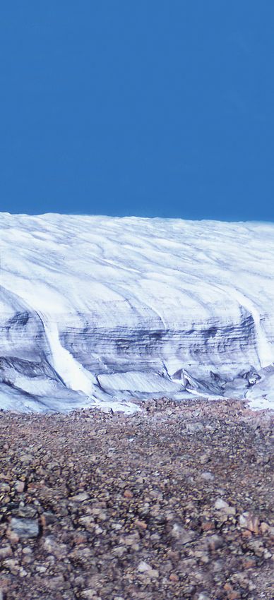
Cover: Terminus of a modern glacier, Nunatarssuaq, Greenland.
Equal opportunity employer M/F/H
Photo by Richard P. Goldthwait.
THE ICE AGE IN OHIO 7You can also read