Conwy Management Catchment Summary - Natural Resources Wales
←
→
Page content transcription
If your browser does not render page correctly, please read the page content below
Conwy Management Catchment
Summary

Date
Contents
1. Background to the Conwy Management Catchment summary ........................................ 3
2. The Conwy Management Catchment ............................................................................... 4
3. Current Status of the water environment ......................................................................... 7
4. The main challenges ........................................................................................................ 9
5. Objectives and measures .............................................................................................. 11
6. What next? ..................................................................................................................... 16
7. Water Watch Wales ....................................................................................................... 16

                                                                                                                   Page 2 of 18
www.naturalresourceswales.gov.uk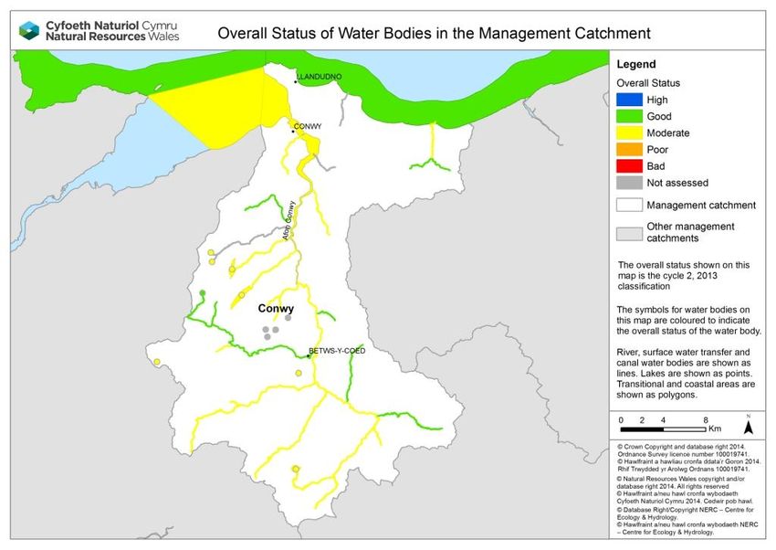
1. Background to the Conwy Management Catchment summary
This management catchment summary supports the current consultation on the updated
river basin management plans. Along with detailed information on the Water Watch Wales
website, this summary will help to inform and support delivery of local environmental
improvements.
Natural Resources Wales has adopted the ecosystem approach. This means being more
joined up in how we manage the environment and its natural resources to deliver
economic, social and environmental benefits for a healthier, more resilient Wales. It means
considering and regulating the environment as a whole, rather than dealing with individual
aspects separately; weighing up and setting priorities for the many competing demands on
our natural resources in a more integrated way. Partnership working is essential to
achieve our ambition. By working together in this management catchment we will:
understand the issues in catchments and how they interact
understand how the issues are affecting the current local benefits and future uses of
water
involve local people, communities, organisations and businesses in making decisions
by sharing evidence
identify which issues to tackle as a priority.
The Water Framework Directive provides a major overarching framework for river basin
management. The Floods Directive sets out a strategic approach to flood risk management
planning. A flood risk management plan has been produced for consultation in parallel to
the river basin management plan and can also be found on our website. The flood risk
management plan details how we propose to manage flood risk across the river basin
district by prioritising those communities that are most at risk of flooding and detailing the
measures we intend to take to manage their risk.
The flood risk management plan and the river basin management plan will shape important
decisions, direct considerable investment and action, and deliver significant benefits to
society and the environment.
As part of the consultation we are asking you for your input on priority opportunities and
how we can make these summary documents as useful and relevant to the management
catchment as possible. Within the river basin management plan consultation documents
are a number of consultation questions; these will provide a useful starting point to gather
your ideas in order to improve not only this document but partnership options to ensure
that we work together to provide the best environmental options. We encourage you to
look at the river basin management plans and respond to the consultation questions which
you can find on our website.
Page 3 of 18
www.naturalresourceswales.gov.uk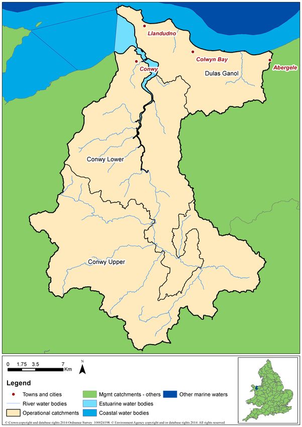
2. The Conwy Management Catchment
Figure 1 Conwy Management Catchment map

                                          Page 4 of 18
www.naturalresourceswales.gov.uk
The source of the Conwy is in the uplands of the Migneint, an extensive area of blanket
bog and part of a Special Area of Conservation. Llandudno, Colwyn Bay and Conwy are
the primary settlements along the coast, with Llanrwst the largest town in the main Conwy
valley. There has been a history of flooding within some of the communities and a major
flood alleviation scheme has been constructed in Llanrwst. Much of the catchment above
Llanrwst and the western side of the lower Conwy Valley lies within Snowdonia National
Park.
Agriculture and forestry dominate the Conwy catchment. Sheep are reared in the upper
catchment, with more mixed livestock in the lower sections. The catchment is an important
salmon and sea trout fishery, though there is a natural barrier to migration on the Afon
Llugwy at Swallow Falls. Recreation and tourism are important to the local economy, with
canoeing, walking, climbing and fishing popular in the Conwy Valley.
The Conwy management catchment contains drinking water supply reservoirs including
Llyn Conwy and Llyn Cowlyd. It makes a significant contribution to energy production with
major hydropower generation at Dolgarrog and off-shore windfarms. There is a legacy of
mining activities particularly in the Gwydyr Forest with abandoned mine shafts, adits, soil
heaps and site run off influencing discharges of metals to surface waters. On the coast
there are EU designated bathing beaches at Llandudno, Colwyn Bay and Abergele, and
sailing from the two large marinas in the Conwy estuary. The estuary contains two
commercial shellfish beds.
In February 2014 a Conwy management catchment workshop was held at Glasdir,
Llanrwst. During this event the benefits of the catchment were captured. These included:
Carbon capture - blanket bogs of the Migneint at the top of the catchment and forestry
Food production - shellfish in the Conwy estuary, upland lamb, beef and milk production
Recreation and tourism - broad range of opportunities, important to economy but also to
health and wellbeing. Examples included iconic views (Llynau Mymbyr at Capel Curig),
bathing waters, fishing, world class white water kayaking, marinas and sailing, hill
walking, wild swimming.
Forestry - multiple benefits, coniferous and deciduous. Timber production, firewood,
recreation, shelter, biodiversity
Cultural and heritage - Welsh heartland, Welsh language, archaeology, history, ancient
monuments and local arts and crafts
An ideal research catchment - education and learning, well studied by Bangor University
and Centre for Ecology & Hydrology
Biodiversity - protected sites and species,
Water - good water quality, supply for drinking, use on farm holdings and hydropower
Energy production – hydropower
Role of landowners as stakeholders and managers
Natural Resources Wales continues to work in partnership with a range of partners and
sectors in innovative ways so that we can achieve even more together. A flavour of some
of the projects that have been delivered within this management catchment over the last 3
years together with projects in development are included below:
Table 1. Partnership projects in the management catchment
Project Name Project Description Partners Funding
sources
Afon Volunteers supported Afonydd Cymru WFD TSO
Wybrnant contractors to install low fund
Page 5 of 18
www.naturalresourceswales.gov.uklevel log weirs designed to
trap and retain spawning
gravel. Follow up visit
identified a Sea Trout
guarding a red on some
spawning gravel
generated at the rear of
the weir.
Afon Iwrch Using fencing to improve Afonydd Cymru, Clwyd & WFD TSO
habitat on the Afon Iwrch Conwy Rivers Trusts fund
around Rhydlanfair
2.1 Key facts
We use the term water bodies to help understand and manage the water environment. A
water body is part, or the whole, of a river, lake, estuary, ground water or coastal water.
The number and type of water bodies in the management catchment is shown in the table
below
Table 2. Number and type of water bodies.
Number of water bodies Natural Artificial Heavily Modified Total
River* 17 0 6 23
Lake 1 0 7 8
Coastal 1 0 2 3
Estuarine 0 0 1 1
Groundwater 5 0 0 5
Total 24 0 16 40
*River water bodies includes canals and surface water transfers
There are areas in the catchment where the water environment is recognised as being of
particular importance, including rare wildlife habitats, bathing waters or areas around
drinking water sources. These areas are known collectively as protected areas and are
detailed in the table below.
Table 3. Number and type of protected areas.
Protected Area Number
Bathing Waters 2
Drinking Water Protected Areas 11
Natura 2000 and Ramsar sites 9
Nitrate Vulnerable Zones 0ha
Shellfish Waters 1
Urban Waste Water Treatment Directive
0
- Sensitive areas
Page 6 of 18
www.naturalresourceswales.gov.uk3. Current Status of the water environment
We assess the condition of water bodies through monitoring which produces an annual
classification. The current status for each water body is shown in figure 2. Note, since
2009, we have updated some of the systems we use to classify water bodies, including
changes to some standards and water body boundaries.
Page 7 of 18
www.naturalresourceswales.gov.ukFigure 2. Current status of the Conwy Management Catchment (new building blocks, interim 2013 classification)
Page 8 of 184. The main challenges
We have carried out a programme of investigations to better understand the causes as to
why water bodies are failing to meet the required standards. The results of our findings are
summarised in Figure 3.
Figure 3. Reasons for not achieving good status
Discharges from abandoned metal mines, both point and diffuse impact a number of rivers
including the lower reaches of the Llugwy, the lower Conwy and the Crafnant. Metal rich
discharges adversely affect river biology, as well as being unsightly. Part of the upper
catchment around Llyn Conwy is acidic, which can cause toxic metals to leach from soils.
Physical modifications, mainly because of impoundments for hydropower, affect water
bodies above Dolgarrog on the western edge of the Conwy management catchment.
Diffuse pollution, both from agricultural and forestry sources affects some rivers. In the
lower catchment bacteria from waste water treatment pose a risk to shellfish beds which
and could make them commercially unviable. They also pose a risk to the quality of the
bathing waters.
4.1 Workshop feedback on challenges
We need to work together to ensure the overall aims of the Water Framework Directive are
met, in order to work together effectively we need to agree on the issues and solutions.
The following section includes some of the issues that were raised as part of the workshop
however it is not a full list. All of the comments received will be taken into account and the
following is just a flavour of these comments.
Acidification in parts of catchment, Lledr and Upper Conwy
Further upland management required
Lack of fisheries protection and need for education of river users e.g. anglers, canoeists
Diffuse pollution from rural land management
Invasive non-native species
More flexibility in agri-environment schemes like Glastir needed
Lack of trees in the farmed landscape
Page 9 of 18
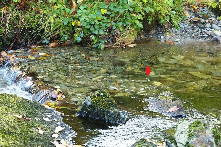
www.naturalresourceswales.gov.ukCase study - Working together to create perfect spawning conditions for
Sea Trout on the Afon Wybrnant
The Afon Wybrnant flows into the Afon Lledr, a tributary of the Afon Conwy,
near Pont Gethin viaduct. The Afon Wybrnant is approx 3km long but only the
lower 400m is accessible to migratory fish due to impassable waterfalls. Over
the years, spates had washed out most of the spawning gravel in this section of
the stream and the aim of the project was to create new areas with a combined
approach of constructing bed-check weirs and re-introducing suitable substrate.
The objectives of the project were to increase the number of juvenile salmonids,
to protect salmonid spawning and nursery habitat and to create habitat suitable
for other species of conservation importance and biodiversity.
Results included:
Installation of eight low level log weirs to trap and retain spawning gravel.
Volunteer engagement on environmental/conservation projects
A follow up visit identified a Sea Trout guarding a redd on some spawning
gravel generated at the rear of the weir (see photograph below)
The project was undertaken by volunteers and a North Wales contractor so
supporting a local business
Page 10 of 18
www.naturalresourceswales.gov.uk5. Objectives and measures
This section outlines what we are aiming to achieve and the proposed new measures that
need to be put in place. We aim to develop a single integrated programme of measures by
2021 that meets Water Framework Directive objectives:
Prevent deterioration in status
Water body status will not be allowed to deteriorate from the current reported status.
Achieve the objectives for protected areas
Achieve the standards set by the relevant directive under which they were designated. For
water dependent Natura 2000 sites we will aim to achieve conservation objectives,
achieving good status by 2021 is a milestone towards this objective.
Aim to achieve good overall status for surface and ground waters
Implement measures to achieve good overall status where they are technically feasible
and not disproportionately costly.
5.1 Measures
We have reviewed the reasons why water bodies are failing to achieve objectives and
identified potential measures .Measures are divided into two groups. National measures
apply to the whole of Wales, or the United Kingdom. In general these set the legislative,
policy or strategic approach. Examples include a national ban on using a particular
chemical or a national strategy for prioritising and funding the remediation of abandoned
mines. Local measures are specific to the river basin district or a part of it. For example,
the removal of invasive plants along a length of designated river or a local campaign
targeting misconnections across an industrial estate. Many of the actions listed will also
have multiple benefits. For example, sustainable urban drainage (SuDs) schemes help to
reduce urban pollution, sewage pollution and changes to water levels.
A list of all national measures, both new and existing, and the local measures at the water
body scale are detailed on Water Watch Wales. If you know about any others or want to
suggest new measures, please tell us in your response to the consultation. The river basin
management plan will become a statutory document hence the importance of ensuring that
the correct measures are identified through this consultation.
The table below summarises the local measures for the management catchment, including
those identified for protected areas. The high level categories describe the types of action
required and broadly the options that are available, including voluntary and regulatory
measures. At the local scale some of the options described might not be considered
appropriate. There is overlap between some categories.
Table 4. Proposed list of local measure for the Conwy Management Catchment .
No. of water
Measure Description
bodies
Emissions controls and upland
restoration: blocking drainage,
restoring blanket bog, within
forestry plantation blocking forest
Acidification restoration 2
drains and establishing native
trees within the riparian zone,
liming options. Some overlap with
"address air pollution".
Address air pollution Emissions controls to reduce 5
Page 11 of 18
www.naturalresourceswales.gov.ukNo. of water
Measure Description
bodies
nitrogen and acidic deposition.
Some overlap with "acidification
restoration".
All ongoing WFD investigations
Complete first cycle investigation 17
from first cycle programme.
Investigate and implement
Drainage and water level changes to land drainage regimes
14
management and structures to restore water
levels.
Reduce impacts of regulated flows
and abstractions, restore more
natural flow regimes, implement
Improve flows and water levels options to improve water levels, 5
such as water efficiency and
recycling measures, alternative
sources and supplies.
Eradication and/or management of
invasive non-native species in line
with current national invasive
Manage invasive non-native species species Action Plans. Includes 7
biosecurity good practice, such as
"CHECK-CLEAN-DRY" and Be
Plant Wise.
Coal and metal mine, and
contaminated land remediation -
Mine water and contaminated land including passive and active mine
5
remediation water treatment, capping of spoil,
removal of wastes to landfill, and
channel diversion
Assess and implement options for
Mitigate impacts of shipping, adapting dredging regimes and
4
navigation and dredging reducing the impacts of physical
modifications.
Assess and implement options for
Mitigate impacts of water resource
improving fish passage and 2
impoundments
habitat.
Includes investigations for all new
New Investigation failures, deterioration, and drinking 21
water protected areas.
Target actions to ensure septic
tanks are maintained correctly.
Reduce pollution from septic tanks Where necessary issue formal 2
works notices to owners to relocate
or replace tanks and soakaways.
Reducing pollution from continuous
Reduce pollution from sewage and intermittent discharges,
3
discharges includes additional treatment at
sewage treatment works (e.g.
Page 12 of 18
www.naturalresourceswales.gov.ukNo. of water
Measure Description
bodies
phosphate stripping), investigating
and tackling sewer blockages, and
implementing sustainable drainage
to reduce surface water drainage
to sewers.
Restoration and/or conservation of
specific habitat and features,
Specific habitat and feature works including natural (e.g. caves, 3
geological outcrops) and human
structures (e.g. bridges, ruins).
Reduce the impacts of erosion,
disturbance and damage from both
Sustainable access and recreation
water-based and terrestrial access, 19
management
including tackling illegal off-
roading.
Reduce and mitigate impacts of
Sustainable aggregate extraction 3
extraction industries
Implement basic and additional
measures such as correct
management of slurry, silage, fuel
oil, and agricultural chemicals;
clean and dirty water separation;
Sustainable agricultural practices nutrient management planning; 25
buffer strips and riparian fencing;
cover crops and soil management.
In N2k sites changes to grazing
regimes may be required, includes
scrub management.
Includes off-shore energy
Sustainable marine development developments, such as oil and gas 4
exploration and tidal energy.
Restore the riparian zone,
disconnect forest drains, monitor
Sustainable woodland and forestry the effectiveness of the 5 principle
5
management risks associated with forestry and
use forestry and woodland to
reduce diffuse pollution.
Investigate and solve
misconnections to surface water
drains (at residential and
Tackle misconnections and urban
commercial properties) and 2
diffuse pollution
implement sustainable drainage
schemes (SuDS) to reduce diffuse
pollution.
Total 148
Page 13 of 18
www.naturalresourceswales.gov.ukActions already under way in the Conwy catchment include:
Welsh Water and private sewage dischargers are working to ensure appropriate
treatment of waste water.
Bangor University is researching innovative solutions for issues with shellfisheries
Natural Resources Wales is improving forest management to reduce the impact of
acidification and protect rivers from sediment
Land owners are minimising the impact of agricultural land management on rivers by
controlling runoff, avoiding bank side erosion and encouraging best practice
NRW is investigating the sources and solutions for abandoned metal mines including
detailed catchment studies, flow reduction measures at Parc Mine and flow monitoring
at Pandora mine
Eryri and Hiraethog Peatland Restoration Project – restoration work including ditch
blocking to restore hydrological integrity and vegetation. Partners in the Conwy include
National Trust and Snowdonia National Park.
Nant Gwryd native tree planting, fencing and in river habitat restoration by NRW,
Afonydd Cymru and National Trust.
Afonydd Cymru installed low level log weirs designed to retain spawning gravels in Afon
Wybernant a tributary of the Afon Lledr.
NRW have worked with partners on the Hiraethlyn, Nant Gwryd and Iwrch water bodies
as part of our focus during the first river basin cycle.
5.2 Workshop feedback on solutions
Of the challenges raised at the management catchment workshop, the following solutions
were proposed:
More flexibility in agri-environment schemes like Glastir needed
Proposed solutions include: Continue to influence WG of the need to make
changes to scheme to deal with local issues and enable a more strategic catchment
approach.
Acidification in parts of catchment, Lledr and Upper Conwy
Proposed solutions include: Improved forestry management with buffer strips,
ensure continuous cover forestry, consider use of lime, conditions on felling licence
and education of landowners and managers.
Invasive non-native species
Proposed solutions include: Need coordination at a landscape scale, work more
closely with Network Rail (NRW role), and better utilise community resources, for
example: community service as volunteer work to provide skills and education.
Need for control of species at ecosystem level, more collaborative working between
interested parties with a management plan.
Further upland management required
Proposed solutions include: Scope for more grip blocking, with multiple benefits,
including carbon storage and flood attenuation.
Diffuse pollution from rural land management for example sediments and
nutrients
Proposed solutions include: More soil testing, farmer education, fertiliser
management, drivers in Glastir and cross compliance to assist. Reduce forage
crops in high risk areas, targeted planning for tree planting.
Page 14 of 18
www.naturalresourceswales.gov.uk5.3 Alternative objectives
We have identified a small number of water bodies where because of the nature of the
problem or the required measures we propose an extended deadline or less stringent
objective (less than good). In each case we have provided a justification.
Table 5. proposed alternative objectives and justifications
Number
Alternative of
Justifications Water body
objective water
bodies
Extended Natural conditions – recovery Llyn Conwy
2
deadline time from acidification Llyn Cwmffynnon
Less
Technically infeasible -
stringent 1 Conwy (groundwater)
minewater scheme
objective
5.4 Opportunities for partnerships
There are several external funding opportunities, which could support projects that
contribute towards Water Framework Directive outcomes. Each fund has its own priorities,
budgetary allocation and application process. Types of funding for consideration include:
European funds – The EU provides funding from a broad range of programmes – go to
the Welsh European Funding Office website for more information.
Lottery Funding – such as Heritage Lottery Fund, Postcode Lottery and BIG Lottery
Fund which have a range of programmes from £5000 up to £millions.
Charities, trust & foundations – there are many of these operating and they often have a
specific focus – either geographically or topically and will support local charities and
projects.
Businesses and sponsorship opportunities – including making the most of the Welsh
carrier bag charge!
Public bodies – Local authorities, Welsh Government, UK Government and NRW may
have annual funding opportunities or one-off competitions for their priority areas.
Crowdfunding – gathering support from a wide range and number of funders, often
including individuals and usually using the internet to raise awareness for a specific
project needing funds.
Trading – Increasingly funders are looking to support organisations with longer term
sustainability in mind so developing trading opportunities can be something to consider
too.
Your local County Voluntary Council and Wales Council for Voluntary Action will have up
to date information on opportunities such as these as well as a host of other support
available.
Page 15 of 18
www.naturalresourceswales.gov.uk6. What next?
This summary is intended to be a snap shot of the management catchment and should
enable you to be able to access further detail using Water Watch Wales. We welcome
your views on how we can improve how we do this.
The summary supports the current consultation on the updated river basin management
plans. We encourage you to look at the river basin management plans and respond to the
consultation questions which you can find on our website. If you have any questions,
please e-mail:
ardalbasnafongorllewincymru@cyfoethnaturiolcymru.gov.uk /
westernwalesrbd@naturalresourceswales.gov.uk
7. Water Watch Wales
During the implementation phase of the first river basin management plan many of our
partners and stakeholders requested access to data and information to assist them in
helping to deliver local environmental improvements. It was quite clear early on that the
first plan was difficult to navigate and access at a local scale. Consequently with both the
support and input from the river basin district liaison panels a web based tool has been
developed. This tool is called Water Watch Wales. This is an interactive spatial web-based
tool that provides supporting information and data layers which can assist partners.
We are continuing to develop this tool and see it as a critical link between the more
strategic river basin management plan and local delivery. It should enable the user to
access information on:
classification data at the water body scale
reasons for not achieving good status
objectives
measures/actions, including protected area information
partnership projects
Data can be retrieved in a number of formats (spreadsheets and summary reports). A user guide
together with frequently asked questions is included with the tool and can be accessed
from a link on the home page.
Page 16 of 18
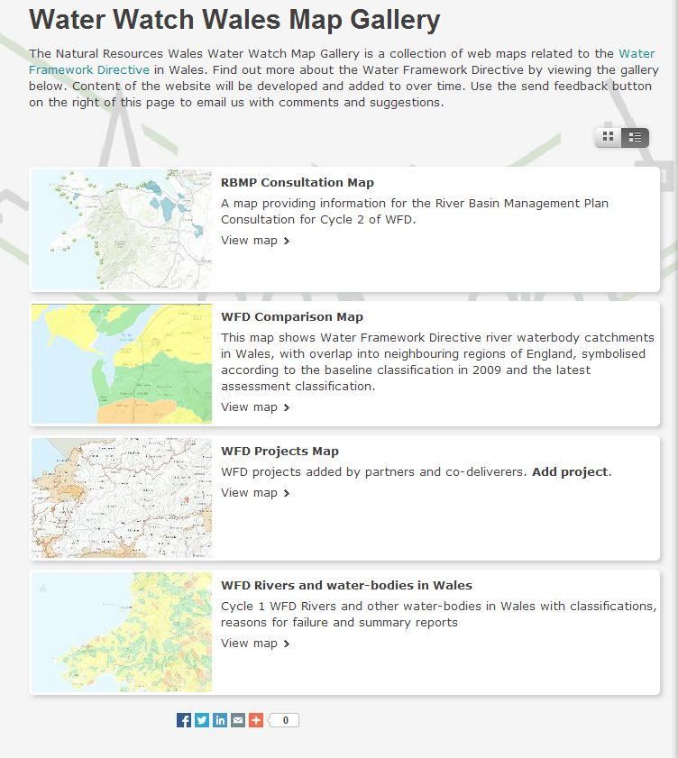
www.naturalresourceswales.gov.ukFigure 4. Opening screen shot for Water Watch Wales
Page 17 of 18
www.naturalresourceswales.gov.ukPublished by: Natural Resources Wales Cambria House 29 Newport Road Cardiff CF24 0TP 0300 065 3000 (Mon-Fri, 8am - 6pm) enquiries@naturalresourceswales.gov.uk www.naturalresourceswales.gov.uk © Natural Resources Wales All rights reserved. This document may be reproduced with prior permission of Natural Resources Wales
You can also read