Iceland, Land of Ice and Fire: Myths, Legends & Landscapes 2022 - Australians Studying Abroad
←
→
Page content transcription
If your browser does not render page correctly, please read the page content below
Iceland, Land of Ice and Fire:
Myths, Legends & Landscapes
2022
18 JUN – 5 JUL 2022                           Code: 22227

Tour Leaders       Professor Heather O’Donoghue

Physical Ratings

Travel through some of the world’s most awe-inspiring
landscapes – of active volcanoes, vast glaciers, great
geysers, boiling springs, gushing waterfalls and dramatic
North Atlantic coastline.
Overview
Join Professor Heather O'Donoghue on this fascinating tour of Iceland, travelling through some of the
world’s most awe-inspiring landscapes – of active volcanoes, vast glaciers, great geysers, boiling springs,
gushing waterfalls and the dramatic North Atlantic coastline.

          View dramatic waterfalls including multi-tiered Gullfoss, Skógafoss and Seljalandsfoss in the south,
          and Goðafoss (the 'waterfall of the gods') and mighty Dettifoss in the north.
          Witness the dramatic interaction between glaciers and the active volcanoes beneath them at
          Deildartunguver, Europe’s largest thermal spring, and the geothermally active Haukadalur Valley,
          location of the 'Great Geysir'.
          On the Snaefellsnes Peninsula, West Iceland, view bizarre basalt rock formations; visit Snaefellsjökull
          National Park – the setting for Jules Verne’s novel Journey to the Centre of the Earth; and cruise
          Breiðafjörður Bay – one of the most important areas of birdlife in the North Atlantic.
          At northeastern Iceland’s Vatnsnes Peninsula visit the Icelandic Seal Centre – its spectacular wild
          coastline supports the country's largest seal colony, and view the unique Icelandic horses,
          descendants of those brought to Iceland by the Vikings.
          Spend two days exploring the area around Lake Mývatn and the Krafla Caldera, visiting
          pseudocraters, lava fields, bubbling mud flats; at Möðrudalur, walk through the ‘lunar landscape’
          where Neil Armstrong and his crew practised for their moon landing.
          While based at Skálafell, south-east Iceland, take a snowmobile across Vatnajökull glacier; a duck
          boat across Jökulsárlón's sparkling glacial lagoon to view icebergs reflecting particles of white,
          black, blue and turquoise; and view the 20-metre-high Svartafoss waterfall.
          Visit volcanoes, and learn about Lakagígar (Craters of Laki), so powerful that its ash cloud covered
          most of the northern hemisphere, from Eurasia to North America.
          Explore the Dyrhólaey Peninsula, where in summer, puffins nest on its cliff faces – Iceland is the
          breeding home of about 60% of the world’s Atlantic Puffins.
          Spend a day visiting Vestmannaeyjar (The Westman Islands), an archipelago consisting of fifteen
          islands and numerous rock stacks and skerries.
          Study the history of the 9th-century Viking discovery and settlement of Iceland and journey through
          the landscapes that inspired its rich mythology; visit a Viking longhouse reconstruction at
          Eiríksstaðir.
          At Þingvellir National Park witness the spot where the world’s oldest Parliament met, and walk
          through the great chasm produced by the Mid-Atlantic Rift (MAR) crossing Iceland; MAR is the
          longest mountain chain in the world (mostly underwater); its discovery led to the theory of seafloor
          spreading and acceptance of continental drift.
          Absorb the power of the Icelandic Sagas, the greatest corpus of Viking literature, in settings such as
          the so-called ‘Golden Circle’.
          Visit remote villages and farms like Glaumbaer Farm Museum, where traditional houses, lived in until
          the 20th century, were constructed with turf walls sprouting grass.
          Wonder at the drama of Icelanders’ past isolated subsistence amidst the tortured landscapes of fire
          and ice and imagine how they survived volcanic eruptions and glacial floods in small fishing villages
          and folk museums, like Skógar Folk Museum.
          Visit sites associated with some of Iceland’s most important writers; in Reykjavík view the Settlement
          Exhibition, the National Museum and the sparkling new Harpa Concert Hall.
          Stay in lovely coastal hotels with fine food and unsurpassed views of the North Atlantic.

          Testimonials

          Iceland is a land of wonders – every day I found myself thinking ‘a photo just can’t do this justice’.

Iceland, Land of Ice and Fire: Myths, Legends & Landscapes 2022                                              Page 2
November 2020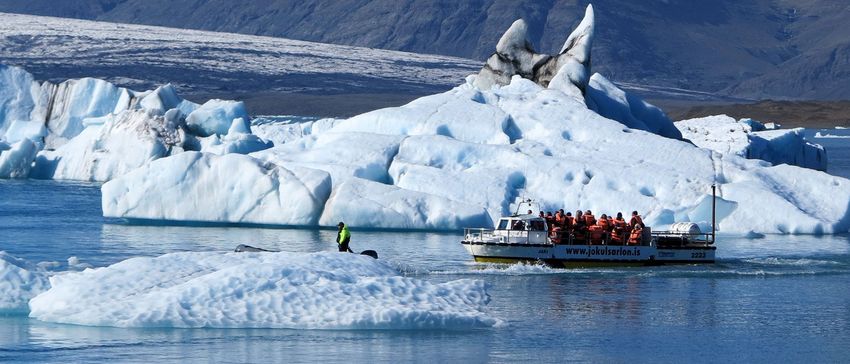
The length and depth of this tour provided not just spectacular scenery and incredible natural
          formations, but an insight into a fascinating culture that has developed alongside glaciers, volcanoes
          and the sea. Icelanders are resilient, hard working and creative and I was so impressed by this
          ‘young’ land and its people. Marji, NSW.

          This tour is a must for your bucket list, especially for those who love exploring human interaction
          with the natural landscape. What a fantastic itinerary ASA has devised, travelling clockwise around
          Iceland, a country about half the size of Victoria. The spectacular experiences continued day by day
          and the tour guides enhanced the experience with their wide knowledge. The mix of glacial
          landscapes and volcanic landforms continued to excite us (retired Geography teachers) as did the
          abundance of birdlife and wildflowers. The human story of the settlement of Iceland is also
          intriguing – a long and complex saga continuing to the present day. We understand so much more
          about the sagas, the AlÞingi (Parliament), the impact of and recovery from GFC, the eruption of
          Eyjafjallajökull (which impacted on international air travel as well as the local farmers) and the role of
          the church, because we were able to visit sites of importance and see and learn every day. We had
          fun driving a skidoo across an icecap, soaking in the thermal baths, scrambling through volcanic
          landscapes and behind beautiful waterfalls and spotting puffins from land and sea. The
          accommodation appeared to be the best available, ranging from motel suites to very classy and the
          meals were excellent, showcasing local produce, particularly seafood and lamb. Don’t leave it too
          long to visit – tourists are flocking in and don’t be tempted by a shorter trip. There is so much to see
          and do. Howard and Jenny, VIC.

18-day Cultural Tour of Iceland

Overnight Borgarnes (1 night) • Stykkishólmur (2 nights) • Laugarbakki (1 night) • Siglufjörður (1 night)
• Akureyri (1 night) • Lake Mývatn (2 nights) • Egilsstaðir (2 nights) • Skálafell (2 nights) • Vík (2 nights)
• Reykjavík (3 nights)

Overview

Iceland is constantly being changed by the powerful plate tectonics of the Mid-Atlantic Rift, where the
North American and Eurasian tectonic plates slowly separate. It also lies above a hotspot, the Iceland
plume, a postulated upwelling of anomalously hot rock in the Earth's mantle, which is believed to have
caused the formation of Iceland itself. This continues to allow vast quantities of magma to rise to the earth’s
surface, creating the world’s most active volcanic landscape. You will learn about Iceland's extraordinary
geology in places like the Krafla Caldera, whose 18th-century eruption lasted five years, and Eyjafjallajökull,
whose ash cloud brought chaos to the European air industry in April 2010. You’ll also gain a close up view
of some of the world’s greatest glaciers and witness the effects of the interaction of a glacier and volcanic
activity beneath it at places like Deildartunguver, that produces boiling hot springs. Remote, isolated,
daunting Iceland remained unknown to humans until 9th-century Vikings reached its shores. Their
experience produced one of the world’s most magnificent epic cycles – the Icelandic Sagas – that drew
inspiration from this awesome landscape. For the next millennium Icelanders, alone in this remote land,
eked a subsistence living from this violent landscape, that through volcanic eruptions and glacial floods,
frequently threatened human existence. Only with the development of the herring industry did this poor,
isolated land begin to develop a modern economy. This tour through some of the world’s most tortured
landscapes combines unforgettable scenery and a unique, well-informed view of the power of plate
tectonics with an imaginative ‘sense of place’ as we journey through the settings of the Icelandic Sagas.
You’ll visit Europe’s greatest glaciers and volcanoes; most extensive hot springs; witness geysers in the
Haukadalur Valley, whose greatest example gave ‘geysers’ their name; observe an extraordinary profusion

Iceland, Land of Ice and Fire: Myths, Legends & Landscapes 2022                                                  Page 3
November 2020
of bird life, including Atlantic Puffins at the Coastal Bird Sanctuary, Dyrhólaey; take a snowmobile ride up Vatnajökull glacier; take a duck boat across Jökulsárlón glacial lagoon to view icebergs reflecting particles of white, black, blue and turquoise; visit Snaefellsjökull National Park an area that inspired Jules Verne’s Journey to the Centre of the Earth, and wonder at the great fissure created by the North Atlantic Rift as it crosses Iceland. If you’re a keen photographer or just appreciate unique wilderness, this tour is for you! Iceland, Land of Ice and Fire: Myths, Legends & Landscapes 2022 Page 4 November 2020
Leaders
                     Professor Heather O’Donoghue

                     Prof. Heather O'Donoghue of
                     Linacre College at the University of
                     Oxford, is a world authority on Old
                     Norse-Icelandic literature, and its
                     influence on later poets and authors.
                     She has also published on
                     contemporary fiction and is a judge
                     for the Ian Fleming Steel Dagger
                     Award for contemporary thrillers.

Professor Heather O’Donoghue is a Fellow at Linacre College at the University of Oxford. Professor of Old
Norse, she is an expert in Old Norse-Icelandic literature, not only on the poetry and prose of medieval
Iceland and Norway, but also on its relationships with the contemporary literatures of England and Ireland.
She has also explored the influence these Old Norse-Icelandic myths and sagas have had on post-medieval
English literature, such as the work of William Blake, Wordsworth and Coleridge, Walter Scott, William
Morris, W.H. Auden, and Seamus Heaney; and most recently on the American novelist Neil Gaiman, and
German writer Gunter Grass. Current research centres on how saga narratives are structured, and she is
writing a book about the Anglo-Saxon epic poem Beowulf. Heather has also published on contemporary
crime fiction, and has just finished a term as a judge on the Ian Fleming Steel Dagger Award for
contemporary thrillers, after many years as a judge on the Gold Dagger panel.

Outside academia, Heather’s main interests are birdwatching, natural history more generally, and watching
football. Based in Oxford, she spends part of the year in rural Ireland with her husband and family. Heather
led ASA's tour 'Iceland, Land of Ice and Fire: Myths, Legends and Landscapes' in 2018 & 2019.

Combine this tour with

Shetland & Orkney: Archaeology and Wildlife of the Northern Isles 2022
30 MAY – 16 JUN 2022

The Scottish Highlands: Great Country Houses, Castles & Gardens 2022
30 MAY – 13 JUN 2022

Iceland, Land of Ice and Fire: Myths, Legends & Landscapes 2022                                        Page 5
November 2020
Itinerary
The detailed itinerary provides an outline of the proposed daily program. Participants should note that the
daily activities described in this itinerary may be rotated and/or modified in order to accommodate changes
in opening hours, road conditions, flight schedules etc. Participants will receive a final itinerary together
with their tour documents. The tour price includes daily buffet breakfast and 28 meals, indicated in the
itinerary where B=buffet breakfast, L=lunch and D=dinner.
Picnic Lunches
During the program, weather permitting, 4 picnic lunches are planned. Knives, forks, spoons, plates and
cups will be provided. These lunches are indicated in the itinerary where P*=picnic lunch.
Borgarnes - 1 night
Day 1: Saturday 18 June, Reykjavík – Borgarnes
Transfer from Reykjavík Airport to Borgarnes for participants arriving on the ‘ASA designated’ flight
Welcome Dinner
Our tour commences in Borgarnes, capital of the county of Borgarfjörður, located some 70 kilometres north
of Iceland’s capital, Reykjavík. Those arriving on the ASA ‘designated’ flight will be transferred by private
coach to Hotel Hamar, on the outskirts of Borgarnes, which has fine views of the surrounding countryside.
Tonight we enjoy a welcome dinner at our hotel. (Overnight Borgarnes) D
Stykkishólmur - 2 nights
Day 2: Sunday 19 June, Borgarnes – Snaefellsnes Peninsula – Stykkishólmur
The Settlement Centre, Borgarnes
Hraunfossar (Lava Falls)
Iceland, Land of Ice and Fire: Myths, Legends & Landscapes 2022 Page 6
November 2020Barnafoss (Children’s Falls)
Deildartunguver Thermal Spring
Gerðuberg Basalt Columns, Snaefellsnes Peninsula
Black Church of Búdir, Snaefellsnes Peninsula
Arnarstapi Coastal Trail, Snaefellsnes Peninsula
We begin this morning with a visit to the Settlement Centre, which offers fascinating insights into the history
of Icelandic settlement and the Saga era. The centre features two main exhibitions. One is devoted to the
story of the first Viking settlers in Iceland. The Egil’s Saga exhibition recounts the amazing adventures of
Egil Skallagrímsson, who embodied all the contradictions of the Viking age in a single character, as he
appears not only as a fighter, but also, unlike medieval English literary images of Viking marauders, also as a
trader, farmer and poet.
Departing Borgarnes, we make an excursion to the waterfalls of Hraunfossar and Barnafoss and the thermal
area of Deildartunguver. Hraunfossar (Lava Falls) is an intriguing series of springs that issues from the
Hallmundarhraun lava flow. The gentle cascades of bright, turquoise water emerge from under the moss-
covered lava to tumble down a series of rock shelves into the river over a distance of about 900 metres. In
contrast, Barnafoss (Children’s Falls) is far more lively; it was here that two children fell to their deaths when
crossing a narrow stone arch that once spanned the river. A modern footbridge now affords an excellent
view of the water churning violently as it channels through the ravine below. Deildartunguver, Europe’s
largest hot spring, has a very high flow rate (180 litres/second); the temperature of the emerging water is
98°C.
We spend the afternoon exploring the fascinating Snaefellsnes Peninsula, which contains the Snaefellsjökull
glacier and was the setting for Jules Verne’s book Journey to the Centre of the Earth. The peninsula is also
the main setting of the Laxdaela Saga – one of the most important Icelandic sagas. This saga is unique in
medieval Icelandic literature, in that the majority of the central characters are women, suggesting that the
author was female. The saga is a heroic tragedy running over several generations, where conflicting loyalties
subvert the bonds of family and lead to a blood-feud.
At Gerðuberg we meet with a local geologist and view the impressive ‘natural’ wall of hexagonal basalt
columns which range from 7 to 14 metres in height. These cliffs of dolerite, a coarse-grained basalt rock,
were formed when flowing lava, cooled by the sea, were solidified in very evenly running columns.
We continue west along the southern coast of the Snaefellsnes Peninsula for a walk along the white, shell
sand beach at the abandoned fishing village of Búdir. Surrounded by a vast lava field, the site features a
tiny pitch-black church dating from 1703, and unsurpassed views out over the Atlantic.
The sleepy coastal village of Hellnar was for centuries one of the largest fishing towns beneath the
Snaefellsjökull ice-cap. Remnants of fishing sheds built by Hellnar’s 11th-century settlers may still be viewed.
The Snæfellsjökull glacier lies atop a 1,446m high stratovolcano that last erupted around 250 AD. The
national park, inaugurated in 2001, extends down from the glacier and volcano to cover the entire western
tip of Snæfellsnes Peninsula. The cliffs between Hellnar and Arnarstapi constitute a nature reserve and the
trail linking the two settlements offers spectacular views including Gatklettur, a magnificent arch extending
into the sea. The peculiar Badstofa caves are known for their unique light refraction and colourful interiors.
Other natural highlights we shall view include bizarre rock formations in the form of stacks, as well as cliffs
swarming with huge colonies of birds.
Following our walk along the Arnarstapi Coastal trail we continue to the fishing village of Stykkishólmur,
beautifully situated on the northern side of the Snæfellsnes Peninsula in West Iceland. (Overnight
Iceland, Land of Ice and Fire: Myths, Legends & Landscapes 2022 Page 7
November 2020Stykkishólmur) BP*D
Day 3: Monday 20 June, Stykkishólmur – Snaefellsnes Peninsula – Stykkishólmur
Breiðafjörður Bay: Bird & Nature Watching Cruise
Ólafsvík Maritime Museum
Bæjarfoss Waterfall
Bjarnarhöfn Farmstead: Shark Museum & Church
Stykkishólmur is situated on the widest fjord in Iceland, called Breiðafjörður (broad fjord). This fjord is one of
the most important areas in the whole of the North Atlantic for birdlife. In addition to the Icelandic breeding
birds, thousands of other migratory birds pass through Breiðafjörður on their way from Western Europe to
and from their nesting grounds in Greenland and the northern part of Canada. The main reason for such
rich birdlife here is an abundance of food, resulting from the interplay of the geography, great differences
in tide levels and the sea’s richness. Around 65% of the rocky shores of Iceland and 40% of all mudflats are
located in Breiðafjörður.
We shall take a cruise amongst the many islands to see the birdlife – including puffins, eider ducks, shags,
kittiwakes, fulmars and the majestic white-tailed sea eagles. During the journey we trawl the ocean bed to
bring on board assorted shellfish, crabs and sea stars, and take the opportunity to sample some tasty fresh
scallops.
Following lunch at a local restaurant by the harbour, we spend the afternoon exploring sites along the
northern coastline of the Snaefellsnes Peninsula. From Breiðafjörður Bay we journey west to Ólafsvík village
and Bjarnarhöfn farmstead. Ólafsvík is the oldest trading town in the country; it was granted a trading
licence in 1687. It has a small aquarium and a maritime museum that contains a fascinating collection of old
fishing boats. Overlooking Ólafsvík is the 50-metre high Bæjarfoss waterfall, which we visit.
Bjarnarhöfn farmstead is the leading producer of hákari (putrid shark meat), a traditional Icelandic dish; the
small museum deals with the biology of the Greenland shark and the lives of seafarers who risked their lives
hunting it. On site there is a private 19th-century wooden church owned by the farmer and his family, with
no other parishioners. (Overnight Stykkishólmur) BLD
Vatnsnes Peninsula - 1 night
Day 4: Tuesday 21 June, Stykkishólmur – Haukadalur Valley – Hvammstangi – Vatnsnes Peninsula
Reconstruction of a 10th-century Viking Longhouse at Eiríksstaðir, Haukadalur Valley
Icelandic Seal Centre at Hvammstangi and Seal Colonies of the Vatnsnes Peninsula
Hvítserkur Sea Stack
Icelandic Horse Show, Gauksmýri Lodge
This morning we journey along the coast of Hvammsfjoður to the Haukadalur valley to visit the remains of
the farm of Eiríksstaðir, one of the most historically significant archaeological sites in Iceland. This was the
starting point for all westward expansion by the Vikings, first to Greenland and later to the shores of North
America. Leif Eríksson (‘Leif the Lucky’) is associated with this site. His father, Erik the Red, founded the
colony of Greenland and gave the country its name. Leif was blown off-course on a voyage to Greenland
and was probably the first European to land on the American continent at ‘Vine Land’. At Eiríksstaðir
archaeologists found the remnants of a 50-square-metre hall dated to 890-980 AD, and, although no timber
was unearthed, they did identify doorways clearly marked with stone paving. An evocative reconstruction of
Iceland, Land of Ice and Fire: Myths, Legends & Landscapes 2022 Page 8
November 2020Eiríkur’s original longhouse now stands in front of the ruins. Its turf walls, 12 metres long by 4 metres in
depth, surround a dirt floor and support a roof made of rafters covered with twigs atop a layer of turf.
We cross the Laxárdalsheiði grassy heathland and continue to Hvammstangi, located on the Vatnsnes
Peninsula in Northwest Iceland. This small fishing village is home to the Icelandic Seal Centre, which
provides informative exhibits on the region’s harbour seals (Phoca vitulina) and grey seals (Halichoerus
grypus) – Vatnsnes Peninsula is home to one of the largest seal colonies in Iceland.
Following lunch in an old restored freezing-house by the sea, we continue exploring the Vatnsnes Peninsula
whose shores blend wild coastline with fertile grazing land for horses and sheep. On clear days the west
side of the peninsula has spectacular views out over the bay towards the needle-sharp peaks of the Strandir
Coast. Weather permitting, we take a short walk to view seal colonies, and Hvítserkur – a striking 15-metre
high basalt stack rearing up from the waves. The rock has two holes at the base which give it the
appearance of a dragon who is drinking.
We end the day with a visit to Gauksmýri Lodge, a horse riding centre located on the Vatnsnes Peninsula.
Here we witness a display of horsemanship and learn the history of the Icelandic Horse and its extra – fifth
– gait called the Tolt. The history of the Icelandic horse can be traced back to Iceland’s settlement in the
late 9th century. Viking settlers brought with them their best horses, most of which were from Germanic
stock. The Icelandic horse was renowned in Norse mythology. Several Norse gods owned horses that
played major parts in their myths. The most famous of these was Sleipnir, the eight-footed pacer. The
influence of the Norse myths can still be seen in Icelandic horsemanship, as many modern riding clubs bear
names of mythical horses, as do several horses. According to the Icelandic Sagas, horses played a vital role
in warfare. (Overnight Hotel Laugarbakki) BLD
Siglufjörður - 1 night
Day 5: Wednesday 22 June, Vatnsnes Peninsula – Blönduós – Varmahlið – Hólar – Siglufjörður
Textílsetur Islands (The Icelandic Textile Centre), Blönduós
Glaumbaer Farm Museum, Varmahlið
Hamlet of Hólar
Today we journey from Laugarbakki to the port of Siglufjorður. We first visit the Icelandic Textile Centre,
located in the the town of Blönduós on the estuary of the Blanda River. The Centre, which aims to promote
and develop Icelandic textiles, regularly hosts students from the Iceland Academy of the Arts. Three shared
studio spaces include a weaving room and dye room. The Vatnsdælur Tapestry by Jóhanna Palmadóttir, a
46-metre embroidered tapestry that illustrates the local Vatnsdælur Saga, is currently being woven here.
We continue our journey to Varmahlið and on to the famous Glaumbaer Farm Museum, a superbly restored
large turf-roofed farmstead. Glaumbaer was founded in the (Viking) Settlement Period, but is now
composed of a row of turf-walled, turf-roofed dwellings with painted wood façades; these were inhabited
until 1947. Their lop-sided, hobbit-like construction, with wood-framed windows set into their thick grass-
covered turf walls, gives them a charmingly rustic appeal but they are also a powerful reminder of the
impoverished lives many people led in Iceland before the 20th century.
From here we drive the lovely coastal road through the county of Skagafjoður, which is famous for its
horses, and along the Skagafjorður Fjord. We pause at Hólar, the Episcopal See for Northern Iceland, and a
cultural and educational centre for almost 7 centuries (1106-1798). Bishop Jón Ögmundsson founded the
diocese in 1106 and it soon became one of Iceland’s two main centres of learning; the country’s first
Iceland, Land of Ice and Fire: Myths, Legends & Landscapes 2022 Page 9
November 2020printing press was established here in 1530. Today, with a population of around 100 people, this small
community is home to the Hólar University College and the Centre for the History of the Icelandic Horse.
In the late afternoon we continue to the town of Siglufjorður. This small settlement sits on a narrow shelf on
a deep bay that is surrounded by mountains; until 1946 it could only be reached by sea. Our hotel is
located on its shores. (Siglufjorður) BP*D
Akureyri - 1 night
Day 6: Thursday 23 June, Siglufjörður – Akureyri
Herring Era Museum, Siglufjörður
The Akureyri Botanical Gardens
Akureyrarkirkja (The Church of Akureyri)
Time at leisure in Akureyri
Laufás Hertiage Site and Museum
When Norwegian fishermen began salting herring in the tiny village of Siglufjörður in 1903 it became the
centre of the herring industry that initiated the transformation of Iceland, after a millennium of isolation and
poverty, into a modern affluent nation. The industry reached its peak in 1950. Seventeen years later, the
herring disappeared and the industry died. We shall visit the Herring Era Museum, a maritime and industrial
museum depicting the ‘glory days’ of Iceland’s herring fisheries and industries. The first exhibit,
Róaldsbrakki, is a fully-restored 1907 Norwegian-built herring salting station. The second
exhibit, Grána, houses a re-built herring oil and meal factory from the 1930s to1950s. The Boathouse, which
opened in 2004, contains a recreation of the town’s thriving 1950s harbour with many old fishing boats at
the dock.
From Siglufjörður we drive to the capital of the north, Akureyri, situated by the Eyjafjorður (Island Fjord),
surrounded by snow-capped mountains. Akureyri (pop. 15,000) is Iceland’s largest town outside Reykjavík. It
is famous for its good weather due to the influence of the Gulf Stream and has many well-established trees
and gardens.
Our tour of Akureyri includes a visit to the local museum and the most northerly botanical gardens in the
world. The gardens include a noteworthy collection of Icelandic flora along with many high-latitude flowers,
trees and shrubs from around the world. Note: as an alternative to visiting these sites, weather-permitting,
there will be an option (at your expense) to join a whale-watching cruise.
Guðjón Samúelsson, the architect of Reykjavík’s extraordinary Hallgrímskirja (church), also designed the
Lutheran Church of Akureyri that towers above the city. Built in 1940 in a distinctive modernist style, the
church contains a large 3200-pipe organ and some rather eccentric reliefs of the Life of Christ. There’s also
a ship model suspended from the ceiling that reflects an ancient Nordic practice of donating votive
offerings for the protection of loved ones at sea. Perhaps the most striking feature, however, is the beautiful
central stained-glass window in the chancel.
Following our visit to the church and some time at leisure to explore the town, we visit the heritage site and
museum at Laufás. Laufás is mentioned in historical records soon after the settlement of Iceland (874-930)
and since the earliest period of Christianity a church has been located there. The site, which includes an old
rectory dating from 1840, was home to priests from 1047 until 1935. The farmhouse, which was rebuilt
between 1853-1882, is considered to be the prototype of Icelandic architecture, although significantly
larger than the ordinary Icelandic farmhouse. It was built to accommodate between 20 and 30 people who
Iceland, Land of Ice and Fire: Myths, Legends & Landscapes 2022 Page 10
November 2020were necessary to undertake the various farming activities which included haymaking and the collection of
eiderdown. The current buildings are furnished with household items, clothes and utensils from the
beginning of the 20th century. One of Laufás characteristics is the Bridal room where brides prepared
themselves for the big event. The existing church, built in 1865 features a pulpit dating from
1698. (Overnight Akureyri) BD
Lake Mývatn - 2 nights
Day 7: Friday 24 June, Akureyri – Lake Mývatn
Goðafoss – ‘Waterfall of the Gods’
Mývatn Nature Baths
Sigurgeir Bird Museum
Time at leisure to explore Lake Mývatn’s nature trail
This morning we journey to Lake Mývatn, set in an area of diverse volcanic activity with examples of all
volcanic structures, including a huge explosive crater, Hverfjall, pseudocraters, and Dimmuborgir (‘Dark
Castles’), a lava lake drained to expose huge lava stacks. It is a landscape of mountains torn apart by
volcanic activity and volcanoes whose old lava flows after many years are still hot. Steam rises from the
ground everywhere, including from the tops of mountains. There are hot, bubbling mud pools along with
gushing, hissing steam vents; this area sits astride the Continental Rift System.
We begin with a visit to Goðafoss, ‘Waterfall of the Gods’, so named because, according to the Icelandic
Saga of Christianity, Thorgeir, a former pagan chieftain, denounced his beliefs by throwing wooden carvings
of pagan gods into the falls. Here, the water of the River Skjálfandafljót majestically falls 12 metres from a
width of 30 metres.
From Goðafoss we continue to Mývatn for a leisurely soothing dip in the nature baths, in warm thermal
waters that are extremely relaxing. We also visit a private bird museum established by Sigurgeir Stefansson.
The museum displays about 180 species of birds and more than 300 specimens. Many duck species may
be viewed directly in front of the museum, including the Barrow’s goldeneye (Bucephala islandica) whose
main breeding habitat in Europe is by Lake Mývatn.
The remainder of the afternoon is at leisure for you to enjoy a leisurely walk around the lake. (Overnight
Lake Mývatn) BP*D
Day 8: Saturday 25 June, Lake Mývatn
Skútustaðir Pseudocraters
Dimmuborgir (‘Dark Castles’)
Hverfjall tuff ring volcano
Námaskarð Hot Bubbling Pools
Leirhnjúkur Lava Fields & Krafla Caldera
Stóra-Viti Crater
A pseudocrater looks like a true volcanic crater, but is not. These distinctive landforms are created when
flowing hot lava crosses over a wet surface, such as a swamp, a lake, or a pond, causing an explosion of
steam through the lava. The explosive gases break through the lava surface in a manner similar to a phreatic
eruption, and flying debris builds up crater-like features which can appear very similar to real volcanic
craters. Pseudocraters are also known as rootless cones, since they are characterised by the absence of any
Iceland, Land of Ice and Fire: Myths, Legends & Landscapes 2022 Page 11
November 2020magma conduit which connects below the surface of the earth. A classic locality for pseudocraters is the Lake Mývatn area of Northern Iceland that was formed 2,300 years ago by basaltic lava eruption. The lava flowed down the Laxárdalur Valley to the lowland plain of Aðaldalur, where it entered the Arctic Ocean about 50 kilometres away from Mývatn. There was a large lake in the area at the time, a precursor of the present-day Mývatn. When the glowing lava encountered the lake some of the water-logged lake sediment was trapped underneath it. The ensuing steam explosions tore the lava into small pieces which were thrown up into the air, together with some of the lake. Repeated explosions in a number of locations built up groups of pseudocraters, which now dominate the landscape on the shore of Lake Mývatn and also form some of its islands. Led by a local geologiest, we visit a group of such craters at Skútustaðir on the south shore of the lake. Nearby we visit Dimmuborgir (dimmi ‘dark’, borgir ‘castles’), a large area of unusually shaped lava fields east of Mývatn. The area is composed of various volcanic caves and rock formations, reminiscent of an ancient collapsed citadel (hence the name). Its most distinctive features are contorted crags and pillars reaching 20 metres in height. Dimmuborgir was formed around 2,200 years ago, when molten lava formed a temporary ‘lava lake’ on the site. Eventually the lava found an outlet and drained into Mývatn, but hardened pillars had formed around steam vents (lava finds steam chilling) and were left behind. The surface of the lava lake had half-congealed, and left all kinds of crusty ‘watermarks’ on its way out. In Icelandic folklore, Dimmuborgir is said to connect earth with the infernal regions. In Nordic Christian lore, it is also said that Dimmuborgir is the place where Satan landed when he was cast from the heavens and created the apparent ‘Helvetes katakomber’ which is Norwegian for ‘The Catacombs of Hell’. From Dimmuborgir we travel to the Hverfjall tephra cone and take a walk up to the crater which is approximately 1 kilometre in diameter. The volcano which erupted 2500 years ago has spread tephra all over the Lake Mývatn area. If you’ve ever longed to walk upon the barren red terrain of Mars, experiencing Námaskarð will get you close. Situated on the north side of Lake Mývatn, this geothermal wonder of hot sulfuric mud springs and steam springs is otherworldly. Black rivers and bubbling pools of sulfuric mud cut through a landscape that is rich with colourful minerals and is continuously steaming. Next we view the Krafla Caldera, an active volcanic region consisting of steaming vents, brightly coloured craters and aquamarine lakes. The heart of volcanic activity is known as the Krafla central volcano, but, rather than a cone-shaped peak, Krafla is a largely level system of north-south trending fissures underlaid by a great magma chamber. Krafla itself has been quite active throughout history. It has erupted 29 times; its last eruption was in 1984. In 1724, Krafla began an eruption that lasted for five years. During this eruption, which was called ‘The Mývatn Fires’, lava flowed from an 11-kilometre long fissure until it reached approximately 20 kilometres in length after one year. Krafla’s most impressive attraction is the colourful Leirhnjúkur crater and its solfataras, which originally appeared in August 1727. It started out as a lava fountain and spouted molten material for two years before subsiding. This is the best place to witness remnants of the 1975 to 1984 eruptions, and may be the most surreal landscape you will ever see. The earth’s crust here is extremely thin and in places the ground is ferociously hot. (** This walk is mostly on level ground and it takes about 40 minutes to reach the lava field. At this point care should be taken when walking through the lava. Stopping to explore and take photos, we shall take a total time of just under 2 hours.) We end our day with a visit to Stóra-Víti, a steep-sided explosion crater, formed by the 1724 eruption, with a blue-green lake at the bottom. A trail circles the rim and descends on the far side to an interesting hot Iceland, Land of Ice and Fire: Myths, Legends & Landscapes 2022 Page 12 November 2020
spring area. (Overnight Lake Mývatn) BLD

Egilsstaðir, East, Iceland - 2 nights
Day 9: Sunday 26 June, Lake Mývatn – Husavik – Egilsstaðir

          Church of Husavik
          Ásbyrgi Canyon, Vatnajökull National Park
          Hljóðaklettar (Echoing Rocks), Jökulsárgljúfur National Park
          Dettifoss Waterfall, Jökulsá Canyon National Park
          Moon-like landscapes of Möðrudalur

We leave the Mývatn area, and journey around the Tjörnes Peninsula, stopping at Husavik to see the lovely
church, before reaching Ásbyrgi Canyon, a horseshoe-shaped depression located in the Vatnajökull
National Park. It measures approximately 3.5 kilometres in length and 1.1 kilometres across. For more than
half of its length the canyon is divided through the middle by a distinctive rock formation 25 metres high,
called Eyjan (‘the Island’), which offers spectacular views. One hundred metre high cliffs rise steeply from
woodlands of birch and willow on the canyon floor. Ásbyrgi Canyon was most likely formed by cataclysmic
glacial flooding of the river Jökulsá á Fjöllum after the last Ice Age. Floods occurred some 10,000 years ago
and recurred some 3,000 years ago. The river has since changed its course and now runs about 2 kilometres
to the east. A legend explains the unusual shape and origin of the canyon differently. Nicknamed ‘Sleipnir’s
Footprint’, it is said that the canyon was formed when Odin’s eight-legged horse, Sleipnir, touched one of
its feet to the ground here. (**The Ásbyrgi walk: this is leisurely, through birch and wild geraniums; 30
minutes there and 30 minutes back, with stops for photos etc. The walk includes steps down to the pool
area, and steps with rail up to the viewing platform – not difficult.)

Weather permitting, we shall enjoy a picnic lunch at the echo rocks at Hljóðaklettar. Here we may view
spectacular patterns of crystallised basalt – spirals, circles, twists, and hefty basalt blocks. The rocks are the
vestigial cones of volcanoes, most of which have been eroded down to the hard plugs of crystallised basalt
that closed off their flows. The sound of the turbulent glacial Jökulsá á Fjöllum River, the second longest
river in Iceland, echoes among the pinnacles. (**Hloðaklettur: the walk to the basaltic areas takes 40
minutes. From there, those who are sure-footed can take a more difficult walk with the driver and assistant
guide, while others explore this area at a more leisurely pace.)

This afternoon we view Europe’s largest waterfall, the mighty Dettifoss. The Jökulsá Canyon National Park
surrounds the 25km long gorge of the Jökulsá River, a powerful glacial torrent, which has its source on the
northern edge of Vatnajökull. The park’s vast waterfalls continue to cut back and lengthen the gorge. The
largest, Dettifoss, which we will visit, is 45 metres high. Though far from being the highest in Iceland, this is
undisputedly the country’s most impressive fall, possibly the most powerful in Europe. The gorge below is
densely wooded in places. It supports interesting flora including several orchids, serrated wintergreen, the
rare Paris-herb (lover’s knot) and fungi, including the edible Boletus caber. This is also one of the best
places in Iceland to see gyrfalcons that prey on the park’s ptarmigan (grouse). (**Dettifoss: the walk to the
falls takes 40 minutes there and 40 minutes back, plus stopping for photos, etc. The path, which
follows level ground amongst boulders, leads down to the edge of the falls, which is wet because of the
spray. Overall the walk is not too difficult; remember to bring a light waterproof jacket for the spray.)

In the late afternoon we journey across moon-like landscapes, such as Möðrudalur, where Neil Armstrong
and his crew spent 6 months training for the moon landing.

We continue to Fljótsdalur Valley, location of Lake Lagarfljót and the city of Egilsstaðir. Here we spend the

Iceland, Land of Ice and Fire: Myths, Legends & Landscapes 2022                                             Page 13
November 2020
first of two nights at Egilsstaðahusið, a lovely farm hotel that stands on the shores of the lake. As in the case
of Loch Ness, locals believe a huge serpent called Lagarfljótsormurinn lives in its depths. (Overnight
Guesthouse Egilsstaðir) BP*D
Day 10: Monday 27 June, Egilsstaðir – Seyðisfjorður – Fljótsdalur – Egilsstaðir
Scenic Route 93 from Egilsstaðir to Seyðisfjorður
Ferry port town of Seyðisfjorður
Historic site of Skriðuklaustur, Fljótsdalur
Today we take the scenic Route 93 from Egilsstaðir, climbing to a high pass then descending along the
waterfall rich river Fjarðará to the ferry port of Seyðisfjorður. Our drive affords wonderful views of Egilsstaðir
and Lake Lagarfljót.
Surrounded by snow-capped mountains, the picturesque town of Seyðisfjorður, with its many splendid multi-
coloured old timber houses, is the most historically and architecturally interesting town in East Iceland. We
shall view a number of the town’s wooden buildings such as the warehouses by the harbour, Seyðisfjorður
school, the town’s oldest home, Nóatún (1871), and the pretty, pale blue church which was built in 1922
using timber rescued from a previous 19th-century church that was blown off its foundations.
Our day includes a buffet lunch at Skriðuklaustur. This historic site contains the ruins of the last medieval
monastery founded in Iceland (1493). Icelandic cloisters were either Augustinian or
Benedictine; Skriðuklaustur monastery is commonly thought to have belonged to the Augustinian Order. All
of Iceland’s nine medieval cloisters were dissolved during the Lutheran Reformation.
The site also contains the former stone farmstead (built in 1939) of author Gunnar Gunnarsson. Often
considered one of the most important Icelandic writers, he wrote the novel Af Borgslægtens Historie (Guest
the One-Eyed) and the autobiographical novel The Church on the Mountain (1923-28). (Overnight
Egilsstaðir) BLD
Skálafell - 2 nights
Day 11: Tuesday 28 June, Egilsstaðir – Djúpivogur – Skálafell
Full day exploring the Eastern Fjords
Teigarhorn Natural Monument and Nature Reserve
Djúpivogur
From Egilsstaðir we take the coastal road that weaves around the eastern fjords to the small fishing
village of Djúpivogur, located on a scenic spit of land jutting out into the Berufjörður Fjord.
Just before reaching Djúpivogur we visit the Teigarhorn Natural Monument and Nature Reserve which is a
world-famous site for zeolites. Here, zeolites are found in hollows and crevices in the rock, coming to light
when wave action breaks rock out of cliff faces. In geological terms, the zeolite formations at Teigarhorn are
connected to dikes extending from the main volcano that was active more than 10 million years ago. Local
merchants and others used to gather rocks indiscriminately here and sell samples around the world.
However, in 1976 Teigarhorn was declared a natural monument and consequently the natural formations
are now strictly protected. Examples of zeolite crystals may be viewed at the small farm museum. There is
also a lovely short walking trail around the coast which is ideal for birdwatching.
Iceland, Land of Ice and Fire: Myths, Legends & Landscapes 2022 Page 14
November 2020After lunch at Framtið Restaurant, which overlooks Djúpivogur’s harbour, our journey continues down the
coast during which we may catch our first glimpse of Europe’s largest glacier – Vatnajökull (jökull means
‘glacier’ in Icelandic). We also pass the port of Höfn, famous for its lobsters, and arrive at our hotel, to enjoy
the vast choice of food on its famous buffet. (Overnight Skálafell) BLD
Day 12: Wednesday 29 June, Skálafell – Vatnajökull – Jökulsárlón – Skálafell
Snow Cat across Vatnajökull Glacier
The Þórbergur Centre
Breiðárlón Glacial Lagoon
Jökulsárlón Beach: Crystal Icebergs and Black Lava Sands
Jökulsárlón Glacial Lagoon: Duck Boat amongst the Icebergs
Vatnajökull (2110m) is the largest glacier in Iceland and the largest glacial mass in Europe. It covers an area
of between 8100 and 8300 square kilometres, and is about one kilometre thick at its thickest point; average
thickness is 400-500 metres. The total ice volume of Vatnajökull is around 3,300 cubic kilometres. In 2008,
Vatnajökull and its magnificent surroundings were declared a national park. Two existing national parks,
Skaftafell in the south and Jökulsárgljúfur in the north, as well as several nature reserves, were integrated
into the newly established Vatnajökull National Park, thereby creating the largest national park in Europe; it
covers 13% of Iceland. The park boasts a stunning variety of landscape features.
This morning we travel by 4 x 4 jeep to the top of Vatnajökull and take a snow cat across the glacier. The
spectacular ride up to the glacier offers sweeping views down into the valleys and over the North Atlantic
Ocean.
Following an early buffet lunch in a ski hut on top of the glacier, we descend and drive to the The Þórbergur
Centre, containing an exhibition dedicated to the great writer Þórbergur Þórðarson (1888-1974). An ironist,
satirist, volatile critic, and ground-breaking achiever in experimental auto-fiction, Þórbergur arguably
remains among Iceland’s most beloved 20th century authors. The centre occupies a prominent purpose-
built site featuring a row of two metre-high book spines that line the side of the building.
The remainder of the afternoon is devoted to visiting the Breiðárlón and Jökulsárlón glacial lagoons. From
the centre we continue further along the coast, where at the south end of Vatnajökull, we first visit
Breiðárlón, a land-locked glacial lagoon.
At Jökulsárlón Beach we view some of the marooned glistening blocks of ice, which have been carried
down from the lagoon by tidal currents and now lie stranded on the black lava sands. While the ocean has
melted some of the icebergs away, many of the ones that wash ashore have been beautifully sculptured by
the wind and water, appearing like sparkling jewels in a vast desert.
We end our day with a visit to the breathtaking Jökulsárlón glacial lagoon, filled with icebergs. The lagoon
was formed by global warming a mere 60 years ago as the Breiðamerkurjökull (a branch of the larger
Vatnajökull) began to retreat. At one time, the glacier reached the sea, but as the ice began to melt more
rapidly, chunks of ice broke off (known as calving) and as they fell, a lagoon was formed.
We take an excursion by duck boat to view icebergs of white, black, blue and turquoise colours sparkling in
the lagoon. Although colourless themselves, icebergs pick up the reflections of particles in the water, ice
and their surroundings. The ones in Jökulsárlón have a special ash lining due to the surrounding volcanoes.
It makes for a very dramatic effect!
Iceland, Land of Ice and Fire: Myths, Legends & Landscapes 2022 Page 15
November 2020Jökulsárlón is also one of the favourite places of the skuas or big seagulls. They are often seen during the
summer where they build nests on the dunes around the area. There is also a notorious nesting ground of
Artic terns. (Overnight Skálafell) BLD
Vík - 2 nights
Day 13: Thursday 30 June, Skálafell – Skaftafell – Kirkjubaejarklaustur – Dyrhólaey Promontory – Vík
Svartafoss (Black Falls), Skaftafell National Park
Skaftafell National Park Visitors Centre and Video
Skaftafellsjökull Glacial Tongue
Kirkjubaæjarklaustur: Video of the Laki Eruption
Eldhraun Lava Field
Reynisfjara Black Sand Beach, Reynisdrangar Basalt Sea Stacks, Reynir Basalt Columns and Cave
Atlantic Puffins, Coastal Bird Sanctuary of Dyrhólaey
This morning we continue to the Skaftafell National Park where we take a walk to the park’s main attraction,
Svartafoss (Black Falls), a 20-metre high waterfall surrounded by magnificent dark hexagonal
basalt columns. (**Svartifoss: the walk to the falls and basalt columns takes approximately 40 mins there and
40 mins back, plus stopping for photos etc.)
Next we visit the park’s Visitors Centre where the story of fire and ice is told, including the way in which
volcanoes and glaciers have formed the surrounding topography and the effects of eruptions and glacial
outburst floods on the daily lives of people.
After lunch there will be an option to take one of Skaftafell’s shortest walks which runs from the Visitor
Centre to the front of Skaftafellsjökull itself. This is an easy thirty-minute walk through low scrub around the
base of yellow cliffs. The woods end at a pool and stream formed from glacial meltwater, beyond which
stretch ice-shattered shingle and the glacier’s 4m-high front. From here you can appreciate how much the
glacier has retreated in recent times, a concerning example of how climate change is steadily affecting the
glaciers.
From Skaftafell National Park we continue to the village of Kirkjubæjarklaustur (‘church farm cloister’), a
former site of a 12th-century convent. Here we view a short film on the Laki eruptions. Lakagígar (Laki
Craters) is a series of craters that were formed in one of the world’s largest mixed eruptions in recorded
history. Now referred to as the ‘Fires of the River Skaftá’, this continuous series of eruptions emitted a vast
quantity of lava and substantial amounts of volcanic ash from a fissure stretching 25 kilometres across the
area west of the ice cap. The first eruption began on 8 June 1783 at the southwest end of the fissure. Lava
flowed across the flat land destroying a large number of farms, stopping just outside the small town of
Kirkjubæjarklaustur on 20 July. The northeast part of the fissure then erupted. From 29 July until well into
October, lava flowed along the course of the River Hverfisfljót and across the countryside on both banks.
Although volcanic activity then began to subside, the eruption was not finally over until February 1784. The
largest crater in the row is a small tuff mountain called Laki, which stands in the middle of the fissure. The
total area of the resulting lava field is 565km² and the estimated volume of volcanic material is over 12
kilometres cubed. The Laki eruptions devastated the island’s agriculture, killing much of its livestock. It is
estimated that perhaps a quarter of Iceland’s population died through the ensuing famine. The Laki
eruption created a haze of dust and sulphur particles over much of the northern hemisphere, over Norway,
the Netherlands, the British Isles, France, Germany, Italy, Spain, North America and even Egypt. Ships
remained moored in many ports, effectively fogbound. Crops were affected as the fall-out from the
continuing eruption coincided with an abnormally hot summer. The eruption is now thought to have
Iceland, Land of Ice and Fire: Myths, Legends & Landscapes 2022 Page 16
November 2020disrupted the Asian monsoon cycle, prompting famine in Egypt. Environmental historians have also pointed
to the disruption caused to the economies of northern Europe, where starvation was a major factor in the
build-up to the French Revolution (1789).
We continue south to Vík, taking a scenic route through extensive lava fields covered in thick layers of moss.
The vast Eldhraun lava field (Fire Lava), was created during the 1783 eruption of Laki. The southern coast of
Iceland is among the most beautiful and dramatic parts of the island state. It is also one of the least
hospitable areas, dominated by washed-out sand and lava flows, and an exposed coastline with no natural
harbours for hundreds of kilometres west of Höfn. Inevitably given its location, it was the first part of Iceland
that many travellers came to, including the very first Norse settler, Ingolf Arnarson.
On arrival we explore the coastline between Vík and the rocky headland of Dyrhólaey. The beach at Vík is
composed entirely of black basalt sand deposited by the nearby Katla Volcano. Here we may view the
Reynisdrangar basalt sea stacks that lie just offshore. Legend has it that the stacks originated when two
trolls unsuccessfully attempted to drag a ship to shore; they were caught by the sunlight at dawn and
turned into needles of rock. We also view the nearby basalt columns and cave at Reynir.
Iceland forms the breeding ground of about 60% of the world’s Atlantic puffins. We shall explore the small
Dyrhólaey Peninsula; in summer puffins nest on its cliff faces. The best time to spot a puffin is in the
morning (7am-10am) or evening (6pm-10pm) since they are out fishing during the day. Many other nesting
birds make Dyrhólaey their summer home, including fulmars, guillemots, razorbills, gannets and seagulls.
The views from the top of this 120-metre high peninsula are breathtaking. In front of the peninsula we may
view the gigantic black arch of lava standing in the sea, which gave the peninsula its name (‘hill-island with
the door-hole’).
We spend two nights at Hotel Dyrhólaey, located 9 kilometres from the village of Vík. (Overnight Vík) BLD
Day 14: Friday 1 July, Vík – Landeyjahöfn – Vestmannaeyjar – Seljalandsfoss – Vík
Sailing from Landeyjarhöfn harbour to Vestmannaeyjar
Eldheimar – Museum of Remembrance, Vestmannaeyjar
Heimaey Circle: Boat Tour
Seljalandsfoss
This morning we take a half-hour ferry ride from Landeyjarhöfn harbour to Vestmannaeyjar (The Westman
Islands), an archipelago consisting of fifteen islands and numerous rock stacks and skerries. The islands were
formed by submarine volcanoes around 11,000 years ago, except for Surtsey, the archipelago’s newest
addition, which rose from the waves in 1963. Surtsey was made a UNESCO World Heritage Site in 2008, but
its unique scientific status means that it is not possible to land there, except for scientific study.
The biggest island, called Heimaey, is home to the town Vestmannaeyjarbær with approximately 4,000
inhabitants. The other islands are uninhabited. Vestmannaeyjar came to international attention in 1973 with
the eruption of Eldfell volcano, which destroyed many buildings and forced a months-long evacuation of
the entire population to mainland Iceland.
On arrival at the historic Heimaey harbour, we visit the Eldheimar Museum of Remembrance whose
exhibition focuses on the 1973 volcanic eruption in Vestmannaeyjar and the Surtsey eruption of 1963.
After lunch we take a one-and-half hour boat tour to view the newly formed volcanic island of Surtsey and
other islands of the archipelago. Among the special features of the islands is the spectacular lava coastline
Iceland, Land of Ice and Fire: Myths, Legends & Landscapes 2022 Page 17
November 2020which features basalt columns, picturesque coves, grottos and deep bird cliffs. All of Iceland’s seabirds can
be found in Vestmannaeyjar: the guillemot, gannet, kittiwake, Iceland gull, and puffin. The puffin is the most
plentiful species (around 10 million birds come here to breed) and is the Vestmannaeyjar emblem. More
than 30 species of birds nest in their millions in the cliffs and grassy ledges, and other species make
irregular appearances. Seals, small types of whale (which can be seen on occasions) and other marine
species are also present in large numbers around the islands.
Late-afternoon we return by ferry to Landeyjarhöfn and take a short walk to view Seljalandfoss, one of the
best-known waterfalls in Iceland. Here the glacier-fed River Seljalandsá leaps from the lip of a 60-metre-high
cliff. (**Seljalandfoss: a very short walk. It is possible to follow a path behind the waterfall, however the trail
is wet and slippery; recommended only for those who are sure-footed). (Overnight Vík) BLD
Reykjavík - 3 nights
Day 15: Saturday 2 July, Vík – Skógar – Friðheimar – Skálholt – Reykjavík
Skógafoss (Wood Falls), Skógar
Skógar Folk Museum
LAVA – Iceland Volcano & Earthquake Centre, Hvolsvöllur
Lunch at Friðheimar Thermal Greenhouse
Historic Skálholt
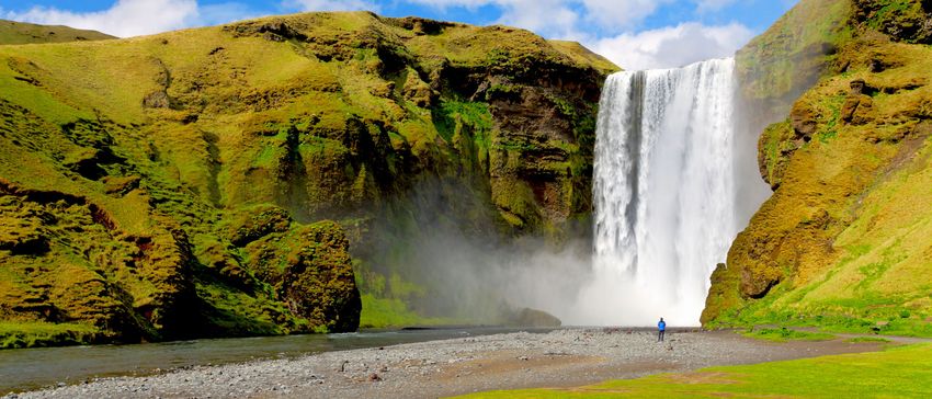
We begin with a visit to Skógafoss, a waterfall situated on the Skógá River rolling over the cliffs of a former
coastline. After this coastline receded seaward 5 kilometres from Skógar, the former sea cliffs remained,
running parallel to the coast for hundreds of kilometres creating, together with a number of mountains, a
precise border between the coastal lowlands and Iceland’s highlands. Skógafoss is one of the biggest
waterfalls in the country with a width of 25 metres and a drop of 60 metres. A single or double rainbow
usually appears on sunny days, in the waterfall’s extensive spray.
Nearby, in the village of Skógar, we visit the wonderful Folk Museum which depicts traditional life in
Iceland. The museum includes a huge variety of tools and implements used for fishing and farming, as well
as artefacts dating back to the Viking age. There is also an open-air museum containing a number of
reconstructed turf houses, and a museum of transport that tells the story of technology and transportation
and its development in Iceland in the 19th and 20th centuries.
Next, we visit the new state-of-the-art Lava Centre. Opened in June 2017, the centre provides an
interactive, high-tech educational exhibition depicting volcanic activity, earthquakes and the creation of
Iceland over millions of years. Located in the town of Hvolsvöllur, the centre lies in the shadow of three of
the country’s most prominent volcanoes, Katla, Hekla and Eyjafjallajökull. The latter became a household
name in 2010 when it released an ash cloud that shut down European air space. The three volcanoes are
visible from Lava’s 360-degree viewing platform, one of the highlights of the centre. Exhibits includes an
earthquake simulator (equivalent to 4 on the Richter scale), an artificial smoke cloud, and an impressive
12-metre high structure simulating the mantle plume and the magma flow underneath the country.
From Hvolsvöllur we continue north for lunch at Fridheimar, a 5,000-square-metre greenhouse that
cultivates delicious tomatoes year-round in an environmentally friendly way. After a lunch of Friðheimar
tomato soup we learn how this family-owned business uses heat from the nearby hot geothermal water
(95°C).
Skálholt is a historical site located by the river Hvitá. From 1056 until 1785, it was one of Iceland’s two
Iceland, Land of Ice and Fire: Myths, Legends & Landscapes 2022 Page 18
November 2020You can also read