Appendix 3 - Monmouthshire County Council
←
→
Page content transcription
If your browser does not render page correctly, please read the page content below

FINAL Version

                                                               December 14, 2018

Appendix 3

 Rights of Way Improvement Plan
(RoWIP)Condition of the Network
    and Opportunities Assessment
                  Report 2017/18

                                                        VERSION 3 final (14/12/2018)

                                 Ruth Rourke Principal Countryside Access Manager

                                                Countryside@monmouthshire.gov.uk

This document is available in Welsh and alternative format on request.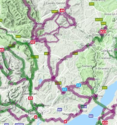
1 CONTENTS
Title                                                                      Page

2.0 Introduction                                                           3-5
        2.1 Aims and Objectives                                            3
        2.2 Production of Assessment                                       4
3.0 What is Monmouthshire Like?                                            5-7

4.0 What Countryside Access Provision is there and What
    Opportunities does it provide?                                         8-15
        4.1 Public Rights of Way                                           8-11
        4.2 Permissive walking and horse riding routes                     11
        4.3 Horse Riding and Carriage Drivers                              11
        4.4 Countryside Sites, Green and Blue Spaces                       11-12
        4.5 Common Land and Village Greens                                 12
        4.6 Open Access Land                                               12
        4.7 Woodlands                                                      12-13
        4.8 Outdoor Education                                              13
        4.9 Cycling                                                        13-14
        4.10 Running                                                       14
        4.11 Watersports                                                   14
        4.12 Agri Environment Schemes                                      14
        4.13 Other types of existing access                                15
5.0 Extent to which the rights of way and other access provision
    meets present and future use                                           16-21
        5.1 Public Rights of Way                                           16
        5.2 Mobility/Health                                                16
        5.3 Cycling                                                        16
        5.4 Horse Riding and Carriage Driving                              16-17
        5.5 Open Space                                                     17-19
        5.6 Participation Rates                                            19-21
        5.6.1 Barriers                                                     21
6.0 Other Issues affecting countryside access in Monmouthshire             22 – 24
        6.1 Climate Change                                                 22
        6.2 Fly-tipping                                                    23
        6.3 Agriculture & BREXIT                                           23
        6.4 Development Pressures                                          23
        6.5 Quality of Life/ Connection to Landscape & Biodiversity        23-24
7.0 The Condition of the Rights of Way Network and its Record              25-40
        7.1 Resources                                                      25-26
        7.2 The Definitive Map and Statement                               27
           7.2.1 Accessibility and up-to-date Definitive Map & Statement   27
           7.2.2 Registers/Land Charges                                    28
           7.2.3 Planning Applications                                     29-30
           7.2.4 Legal Orders                                              30
        7.3 The Condition of the Network – Maintenance & Enforcement       30-38
           7.3.1 Signage                                                   32-33
           7.3.2 Surface Vegetation                                        33
           7.3.3 Stiles & Gates                                            33
           7.4.4 Bridges                                                   35-37
           7.3.5 Enforcement                                               37

                                                  1
7.3.6 Volunteering                                               38
8.0 Promotion & Economic Benefits                                      39-40
9.0 Opportunities to Contribute to Other Plans such as Active Travel   41-50
    9.1 The Well Being & Future Generations Act 2015                   41
    9.2 Active Travel (Wales) Act                                      42-43
    9.3 Environment Strategy 4 Wales                                   43
    9.4 The Environment (Wales) Act 2016                               45
    9.5 The Equality Act 2010                                          45
    9.6 Climbing Higher (2005) and Climbing Higher (2006)              46
    9.7 Creating an Active Wales 2009                                  46-47
    9.8 Planning Policy Wales                                          47
    9.9 Outdoor recreation and Access Enabling Plan 2015-2020          47-48
    9.10 Monmouthshire Corporate Plan 2017 – 2020                      48
    9.11 Green Infrastructure (GI)                                     48-49
    9.14 Severn Estuary Strategy 2015-2020                             49
    9.15 WVAONB Management Plan 2015 -2020                             49-50
    9.16 Brecon Beacons National Park Plans                            50
10.0 Glossary                                                          51
11.0 Bibliography                                                      52-53

                                           2
2 INTRODUCTION
2.1 AIMS AND OBJECTIVES
Monmouthshire County Council approved the current Rights of Way Improvement
Plan (RoWIP) on 3rd October 2007. This plan is the means by which Monmouthshire
County Council identifies, prioritises and plans for countryside access service delivery
and improvements to rights of way in the county. Legislation now requires that we
review the plan and publish another.
Guidance from Welsh Government on reviewing RoWIPs is that the new RoWIP
should be expanded to cover cycle ways, access land and other provision which is
important in our area. In addition guidance says this time we must include within
Monmouthshire’s RoWIP all of the area in Monmouthshire that falls within the Brecon
Beacons National Park.
This assessment report covers the following topics:
The opportunities provided by local rights of way for exercise and other forms
of open air recreation and enjoyment of the county.
An assessment of the extent to which local rights of way meet the present
and likely future needs of the public.
The condition of the rights of way network and its record (Definitive Map and
Statement)
An evaluation of the degree to which the current RoWIP has been delivered.
Resources available to meet people’s needs
Cycling and opportunities to contribute to Active Travel objectives
Opportunities to contribute Well-Being objectives
Opportunities to contribute to The Equality Act 2010
Opportunities to deliver to other plans and objectives
There are separate reports on the following:
An assessment on the delivery of the previous RoWIP
Policy Review
Outdoor disability and health assessment by Ridgeway Consultants
A report on the consultations carried out in this review
The Countryside Access Service provides a statutory service to the residents of
Monmouthshire and its visitors. In order to provide a good service it is important to
seek continual improvement. This assessment report aims to highlight the positive
and negative issues facing the countryside service in order that we can ensure the
new RoWIP is based on sound evidence and will meet the present and future needs
of our residents and visitors.
The conclusions drawn from this report and the other assessments will be used to
formulate the priorities and actions in the new ROWIP for Monmouthshire.
32.2 PRODUCTION OF ASSESSMENT
The approach adopted in developing this report has included:
Information from the Public Service Board Well Being Assessment which was
recently produced following extensive engagement with contributions from
1400 people in Monmouthshire. This also examined a wide range of evidence
and data about what works now and future trends and issues.
Wide consultation using publicity, questionnaire surveys, direct requests for
information to a wide variety of consultees, individual and public meetings.
A detailed analysis of the current condition of the Public rights of way(PROW)
network with particular regard for maintenance and enforcement
A detailed analysis of the current records regarding the Definitive Map and
Statement.
Identification of resources available and required
Research of national, regional and local policies and plans
Review of Countryside Access Management Policies and procedures
Identification and review of other issues affecting countryside access
Research and review of evidence regarding the present and future needs of
the public (publications, websites, leaflets etc.).
43 WHAT IS MONMOUTHSHIRE LIKE?
Monmouthshire lies in the southeast corner of Wales, sharing its border with England
to the east and North. It is a large rural county, covering 850 square kilometres of
countryside with an estimated population of 92,476 half of which live in the main
towns of Abergavenny, Monmouth, Usk, Caldicot and Chepstow.
The County has a distinctive identity arising from its location in the borderlands
between England and Wales. Given its location the County is easily accessible from
both the rest of Wales and England.
Monmouthshire’s greatest asset is its landscape and natural environment.
Monmouthshire has rich and diverse landscapes stretching from the flat open coast
line of the Gwent Levels to the Black Mountains and World Heritage Site in the
Brecon Beacons National Park and the picturesque river gorge of the Wye Valley
Area of Outstanding Beauty. The breath-taking natural scenery here has enthralled
visitors for centuries, including painters and poets from Turner to Wordsworth. The
work undertaken to inform Monmouthshire’s Well-Being Assessment shows the “pull”
people feel to the county and the unparalleled access it can offer to awe- inspiring
environments.
Monmouthshire has major biodiversity and nature conservation resources, a number
of which are internationally or nationally recognised such as The Severn Estuary. This
is designated as a Special Area for Conservation (SAC), Special Protection Area
(SPA), Site of Special Scientific Interest (SSSI) and a RAMSAR site (wetland of
international importance). The former Countryside Council for Wales, now Natural
Resources Wales LANDMAP sets Monmouthshire’s landscape baseline amongst the
highest in Wales. The Landscape and countryside of Monmouthshire is therefore
important in contributing not only to the health and well-being of Monmouthshire’s
residents but in supporting the tourist economy.
Welsh Government statistics for September 20161 show a small projected increase to
the overall population in Monmouthshire to 92,500 (currently 89,000) in 2039. It shows
an expected decrease in 0-15 year olds from 15,000 in 2014 to 14,200 in mid-2029. It
also shows a decrease in the working age population of 15-65 from 57,000 to 52,500
in 2029. However the over 65 age population is expected to increase to 29,800 from
21,300 and over 85’s to further increase from 2800 in 2014 to 5,200 in 2029.
Overall people in Monmouthshire live longer than elsewhere in Wales and are
healthier. However Monmouthshire has an increasingly aged population. Daffodl
Cymru projects an 87% increase in Monmouthshire’s population aged 65 and over
with dementia by 2035. This is above the increase projected across Wales of 72%
and the second highest in Wales. There is also an increase in the number of children
recorded as obese. These are trends which could put significant pressures on the
local authority and health board.
Monmouthshire is reliant on the public sector and services for employment. Tourism
accounts for 12.1% of jobs, higher than the Welsh average. Public administration,
1 Open stats wales 29 sept 2016 SFR 129/2016
5education and health sector accounts for the largest number of jobs, whilst retail,
hotels and restaurants also accounts for 27.4% of jobs.
Tourist expenditure in 2015 amounted to £186.64M supporting 2,744 full-time jobs.
As many as 82% of these jobs were generated directly through visitor
expenditure, with the remaining 18% being supported through the supply chain
and further rounds of expenditure within the economy including employee
spend. Tourism spend supports the most employment in the accommodation
and food & drink sectors. In addition, a significant number of self-employed
people in Monmouthshire earned a living from tourism2.
There is a reliance on car ownership due to the rural nature of the county. Public
transport remains a problem with travel times on public transport considerably
longer in parts of Monmouthshire than elsewhere in Wales. Poor public transport was
highlighted as an issue by the Countryside Access and Disability Assessment report.
There is a strong sense of community and volunteering base in Monmouthshire. This
is particularly seen within Countryside work and an expressed wish for volunteering
opportunities to be expanded and supported. Estimates show Monmouthshire has
the highest rates of volunteering in Wales.
The Draft Green Infrastructure Strategy 2018 has the vision:-
“Monmouthshire has a well-connected multifunctional green infrastructure network
comprising high quality green spaces and links that offer many benefits for people
and wildlife. The network’s integrity and connectivity is maintained, protected and
enhanced in a planned and managed way, which recognises the interdependency
and multi-functionality of landscape, heritage and biodiversity elements. Investment
in green infrastructure underpins the County’s ongoing economic, social and
environmental success by supporting sustainable growth, improving quality of life
and place, delivering ecosystem services and tackling climate change.
Monmouthshire is a green and healthy place to live, with an increasingly coherent
and resilient ecological network of wildlife habitats, helping conserve biodiversity.”
Draft GI Strategy Objectives
1 Improve Health & wellbeing
2 Enhance Biodiversity & Increase Ecosystem Resilience
3 Strengthen Landscape character & Distinctiveness
4 Increase Climate Change resilience
5 Support Sustainable Economic Development
The Biodiversity and Ecosystems Resilience Forward Plan summary of the objectives
are:-
“In order to meet the Section 6 duty, Monmouthshire County Council shall undertake
work and change current procedures to achieve the following objectives, so long as
2 STEAM Survey 2015
6it is consistent with the proper exercise of Monmouthshire County Council’s functions
as a Local Authority. The objectives have been developed to maintain and increase
the resilience of our ecosystems by increasing scale and extent, connectivity,
condition, diversity, and ability of ecosystems to adapt. All objectives apply to both
marine and terrestrial habitats as required by the Act.
Objective 1 : Embed biodiversity throughout decision making at all levels
Objective 2 : Provide environmental education to raise awareness and encourage
action
Objective 3 : Undertake land management for biodiversity and promote ecosystem
resilience
Objective 4 : Influence land management to improve ecosystem resilience
Objective 5 : Tackle key pressures on species and habitats
Objective 6 : Support landscape scale projects and partnerships to maximise
delivery
Objective 7 : Monitor the effectiveness of the plan and review”
In seeking to achieve the ROWIP due consideration will be given to these duties and
requirements the Council is obliged to deliver.
74 WHAT COUNTRYSIDE ACCESS PROVISION IS THERE AND
WHAT OPPORTUNITIES DOES IT PROVIDE?
This section describes and assesses the opportunities available from local rights of
way and other types of access provision to Monmouthshire’s residents and visitors,
for exercise and other forms of open air recreation and enjoyment of the
countryside.
The Countryside Access provision in Monmouthshire is extensive. Monmouthshire is
the gateway to the Brecon Beacons National Park and has canals, rivers, market
towns, food festivals, castles, dark sky discovery sites, walks, horse riding routes,
walking festivals, vineyards, mountains, gorges, caves, hills, Priories & abbeys, Wales
Coast Path, paragliding, museums, paddle boarding experiences and more
traditional past time sites like golf courses. There is therefore no shortage of
opportunity to access the countryside in Monmouthshire for exercise and enjoyment.
Information for visitors and residents can now be found on Monmouthshire’s tourism
website: www.visitmonmouthshire.com
Countryside access contributes to the delivery of well-being objectives as outlined in
Chapter 9.
4.1 PUBLIC RIGHTS OF WAY (PROW)
“Local rights of way” is defined to include all rights of way shown on the Definitive
Map, all other footpaths, bridleways and all cycle tracks at the side of carriage
ways. The scope also extends to include access land and other provision which is
important to our area.
The Definitive Map records minor highways known as public rights of way. These
minor highways are protected by the same highway legislation as the wider
highway network. However they are distinguished from other all-purpose highways
in the way they are recorded and can be used. This is dependent on what their
status is. PROW are broken down into four levels of status:
Footpath, a highway over which the public has a right of way on foot only.
Bridleway, a highway over which the public have a right of way on foot as
well as equestrian and cycling rights.
Byway open to all traffic (BOAT), a PROW open to all types of users, including
use by horse drawn and motor vehicles, but which is mainly used for the
purposes for which footpaths and bridleways are used.
Restricted byway (RB), a new category of highway introduced by the
Countryside and Rights of Way Act 2000 (CROW), over which the public have
a right of way on foot, horseback, bicycle and horse-drawn vehicle. Under
the CROW Act, all PROW which were designated as a Road Used as Public
Path (often denoted as CRB’s or CRF’s on Monmouthshire’s Definitive Map)
were re-designated as Restricted Byways (unless one of the provisions in the
Natural Environment and Rural Communities Act applies).
8There are 2,164.83 kms of rights of way in the County of Monmouthshire and
1609.6kms3 of other public highways (roads). However an agreement is in place for
the 505.78kms of public rights of way in the Brecon Beacons National Park to be
maintained by that Authority. Monmouthshire pays an annual sum to the National
Park Authority for this work.
Table 1 Extent of highway network in Monmouthshire (including BBNP) 2018
Status of Path Km in Mon Km in BBNP Total km in all of Percentage of
Monmouthshire total type of
RoW
Footpath 1490.118 437.188 1927.306 89%
Bridleway 82.454 26.862 109.316 5%
Restricted 84.95 41.73 126.68 6%
Byway
Byway 1.528 0 1.528 0%
Total km 1,659.05 505.78 2164.83
Total km of 1609.6
other Highways
(A, B, and other
roads shown on
list of streets)
Total PROW in 33,200km 6%
Wales
% OF DIFFERENT TYPES OF PUBLIC
RIGHTS OF WAY IN MONMOUHSHIRE
footpath Bridleway Restricted Byway Byway
6%
5% 0%
89%
3https://statswales.gov.wales/Catalogue/Transport/Roads/Lengths-and-
Conditions/roadlength-by-typeofroad-year
9The amount of Bridleways has increased from 71km in 2007 to 82.45 km in 2017. This is
probably because of legal changes to the Definitive Map and the Tread and Trot
project.
Under the provisions of the National Parks and Access to the Countryside Act 1949
Public Rights of Way are recorded on the Definitive Map and Statement. The map
here and Table 1 shows the high
density of rights of way that exist in
Monmouthshire. It also shows the
highly fragmented and limited
bridleway, restricted byway and
bridleway network. Footpaths are
shown as purple lines and other
routes in green.
There are however 459.3km of
County Unclassified Roads “C”
roads (many of which are not
surfaced) which provide access to
all types of users and are essential
links to the rights of way network.
They are particularly useful for
cyclists, carriage drivers and horse
riders.
Monmouthshire has many
promoted routes but the most well-
known are the Wales Coast Path
and Offa’s Dyke Path National Trail,
both of which attract grant funding
because of their status and importance to the regional and national economy of
Wales.
The Wales Coast Path was opened in 2012. It is 870 miles long in all and a total of 2.8
million visitors walked the route in 12 months to June 2013. 14 miles, or 22km, of The
Wales Coast Path runs from Chepstow to Magor. It is maintained by Monmouthshire
County Council in conjunction with Natural Resources Wales, other local authorities
and Welsh Government. The path is promoted by Welsh Government internationally
and was voted by Lonely Planet as the top destination to visit in Wales.
The 870 miles of coast path links with Offa’s Dyke Path National Trail to create a 1030
mile continuous walking route around the whole of Wales. The Wales Coast Path
also links to other routes in Monmouthshire such as the Wye Valley Walk, Tewdrick’s
Trail and a whole host of smaller local circular routes.
The county is also well covered with five other promoted long distance routes, all
with the exception of the Monnow Valley Walk are promoted by Monmouthshire
County Council and or the Brecon Beacons National Park Authority.
1. The Wye Valley Walk
2. The Usk Valley Walk
103. Three Castles Walk
4. St Tewdricks Trail
5. The Beacons Way
6. The Monnow Valley Walk
256.4km of PROW are promoted routes. We also have a series of health walks and
30 pathcare walks which are locally promoted routes (see promotion and publicity).
There is opportunity for other walks to be developed. The Cambrian Way and
Monmouthshire Way are routes where discussion is underway with individuals and
the Ramblers Association to promote and manage the routes in the future. Local
Groups are developing and maintaining circular walks.
4.2 PERMISSIVE WALKING AND HORSE RIDING ROUTES
In addition to public rights of way recorded on the Definitive Map there are also
permissive paths this is where the landowner allows, by his consent, certain users to
use a route on his land either as a footpath or bridleway. These are not that
common and are not usually recorded but we are aware of 4,174m of permissive
footpaths and 3,381m of permissive bridleways. A large percentage of the Usk
Valley Walk and Wye Valley Walk are on permissive routes. The disadvantage of
permissive routes is that they can be closed at any time and they are usually not
maintainable at public expense.
4.3 HORSE RIDING AND CARRIAGE DRIVERS
Despite the lack of bridleways, byways and restricted byways the county has some
superb facilities for horse riders at the Broome Event Centre, Chepstow Race course
and Coleg Gwent. There is also now a series of promoted bridleway routes known
as the Tread and Trot Trails.
Horse drawn carriages are permitted on restricted byways and byways open to all
traffic. Carriage drivers in Monmouthshire advise that they principally use quite
roads of which Monmouthshire has quite a few. There is opportunity to make more
use of county unclassified roads as “quiet lanes” which would benefit more
recreational users by looking at how these routes are signed, managed and
promoted.
4.4 COUNTRYSIDE SITES, GREEN AND BLUE SPACES
Research shows that access to green space is important for the health and
wellbeing of residents.
There are 11 Countryside Service sites including one country park (Caldicot Castle) in
Monmouthshire which provide access for walkers to picnic, kite fly etc. Other county
council small holdings also allow further countryside access opportunities.
Monmouthshire has 44 Historic Parks and Gardens, which have been identified as
having a Special Historic Interest, covering 1,910 hectares.
There are 3 landscapes of “Outstanding Historic Interest”( namely parts of
Blaenavon, the Gwent Levels and the Lower Wye Valley) –and one landscape of
11Special Historic Interest, (the Clydach Gorge) within the Monmouthshire area
identified by CADW in the Registers of Outstanding and Special Historic Interest In
Wales.
To the east of the county The Wye Valley AONB is a popular tourist destination which
attracts significant numbers of walkers, cyclists and day trippers for its scenic beauty,
ecological, geological, historic and cultural attributes.
Chapter 4 looks at “Open Space” provision (parks, play areas, allotments etc.) in
Monmouthshire and whether that provision needs improving.
4.5 COMMON LAND AND VILLAGE GREENS
Common land is owned, e.g. by a local council, privately or by the National Trust.
There is normally a right to roam on foot over it. However some common land has
different rights, so for example the commons in Glascoed can also be used for horse
riding. There is an estimated 3,853.587 hectares of mainly rural commons in
Monmouthshire. Additionally we have 24 village greens which can be used for
sports and recreation, e.g. playing football or walking your dog. Many greens are
privately owned and maintained by local community councils but some may be
privately owned.
4.6 OPEN ACCESS LAND
Walking is still the most popular and growing form of recreation and the CROW Act
2000 has attempted to address this by introducing areas of designated “Open
Access” land for enjoyment on foot.
Open Access land is defined as mountain, moor, heath, down land and common.
In Monmouthshire (outside of BBNP) there is about 150 hectares of mainly rural
commons which are designated as Open Access. In addition National Resources
Wales (NRW) have dedicated 3,550ha of their woodlands as open access in
Monmouthshire. Access Land is shown on Access Maps produced by Natural
Resources Wales and is shown on their website. Access Land is also shown on some
Ordnance Survey maps.
4.7 WOODLANDS
The Woods for People project created a UK wide inventory of accessible woodland
and it is known from this, that in 2014, 43% of woods in Wales were publicly
accessible. The Woodland Trust has undertaken a major analysis of woodland
access provision and deficit across the UK. The project, named “Space for People”
suggests that in 2016 23.6 % of the Welsh population live within 500 metres of a wood
of 2 hectares or more and 80.6% live within 4 kilometres of a larger wood of 20
hectares or more4. The main activity undertaken in woodlands according to the
Wales Outdoors Study is walking. There is however scope to extend other activities
4 Forestry Statistics 2017
https://www.forestry.gov.uk/website/forstats2017.nsf/0e01ca232ca463ed802570a60054c205!CreateDocument
12such as horse riding or cycling more formally over woodlands in Monmouthshire if
landowners agree.
4.8 OUTDOOR EDUCATION
Monmouthshire has an outdoor education service with three sites at Gilwern,
Talybont and Hilston Park. In Monmouthshire Gilwern Outdoor Centre can
accommodate large groups of around 80 people and is set in 15 acres of grounds.
There is a bouldering wall, climbing tower, woodland and large meadow for
camping. As it is not far from Clydach Gorge it can also provide caving
experiences.
Hilston Park in Monmouth is a listed country house just 10 minutes from the River Wye.
It is also therefore ideal for people who like to canoe, fish or walk parts of the Wye
Valley Walk. Offa’s Dyke Path National Trail is also not far away.
Other private companies also offer opportunities to participate in caving, climbing,
canoeing, kayaking, hill walking, camping, raft building, fishing and other adventure
pursuits.
4.9 CYCLING
Cycling in Monmouthshire is very popular with lots of quiet lanes to follow. We have
two of the long distance routes of the National Cycle Network starting in Chepstow:
the Celtic Trail (220miles traversing the southern edge of Wales heading west across
the Newport Transporter Bridge), and Lon Las Cymru (185 miles heading north
through Brecon Beacons to Snowdonia). The map5 below shows the National Cycle
routes available in Monmouthshire.
We are home to the prestigious Abergavenny
Festival of cycling6, which includes on its
programme family rides as well as events which
provide the opportunity to watch professional
riders, including the annual Velothon giving all
the chance to ride the route of champions.
Monmouthshire is also home to “tumble” – a
legendary 6km 10% gradient climb (listed as one
of the greatest cycling climbs in Britain). In
addition Sustrans have and are developing
routes through Monmouthshire. The Peregrine
Way between Wyesham (Monmouth) and
Symonds Yat is popular and they are looking to
extend this route to Redbrook. The cycle way from Llanfoist to Clydach has been
completed and an extension is planned to link the Heads of The valley cycleway at
Beynmawr. The Monmouthshire and Brecon Canal also provides a cycle route from
Llanfoist to Goytre.
5 https://www.sustrans.org.uk/ncn/map
6 https://www.visitmonmouthshire.com/things-to-do/cycling-in-monmouthshire.aspx
13In 2014 a series of “Tread and Trot” routes were made available. These are multi-
purpose mainly off road routes suitable for cyclists, horse riders and walkers.
All of the cycle routes in Monmouthshire can be downloaded at
https://www.visitmonmouthshire.com/things-to-do/cycling-routes-in-
monmouthshire.aspx
4.10 RUNNING
Whether you enjoy a gentle jog or long distance events running is a great way to
enjoy the outdoors and is becoming more and more popular. There are plenty of
places where it is possible to run such as Country parks, village greens and
commons, Open Access Land, footpaths, bridleways and byways, woodlands and
nature reserves.
There are many organised running events in Monmouthshire but these all require
permission from the landowners involved.
Parkrun has a popular parkrun at Rogiet Countryside Park that runs every weekend
and the Severn Bridge parkrun has also recently started.
4.11 WATERSPORTS
Llandegfedd Reservoir operates a brand new water sports centre. It offers land and
water based activities from team building, windsurfing, dinghy sailing, paddle
boarding, kayaking, raft building and environmental studies.
Monmouth Canoe offer canoeing on the river Wye for families, youth and adult
groups in Canadian canoes and single Kayaks.
Close to Monmouthshire is the National Diving and Activity Centre at Tidenham
Quarry in Chepstow7. Here you can experience a complete SCUBA diving package
for beginners through to professionals with speciality diving courses for both the sport
diver and recreational diver. Depths range from 1-82m making this the deepest
inland dive site in the UK.
4.12 AGRI-ENVIRONMENTAL SCHEMES
63 farms in Monmouthshire were within the Tir Gofal agri-environmental scheme,
which in many cases included additional permissive access. This scheme has now
been replaced with Glastir which also includes the provision of permissive access.
However it is not known how extensive this additional access is in Monmouthshire.
Many permissive routes under Tir Gofal are known to still exist but these are not
mapped. The Welsh Government promotes Glastir access on its website through a
mapping system called Lle Map. This also shows the Wales Coast Path, National
Trails and Open Access Land.
7
https://www.visitmonmouthshire.com/thedms.aspx?dms=3&venue=1291730&rgn=Monmouth
shire&catid=28&feature=1000
144.13 OTHER TYPES OF EXISTING ACCESS
There are 100 scheduled ancient monuments in Monmouthshire including 8 castles,
some of which are only accessible by public rights of way.
Other public and voluntary bodies provide access opportunities within the county.
A true gem and a favourite for walkers, cyclists and nature lovers is the
Monmouthshire and Brecon Canal. The navigable section is 35 miles long. This is
managed by The Canal and Rivers Trust.
The National Trust look after mountains (Sugar Loaf & Skirrid), meadows, woodlands
(St Marys Vale), waterfalls and traditional hill farms across Monmouthshire as well as
a medieval castle (Skenfrith Castle) and a naval temple (The Kymin). This not only
allows for a diverse range of landscapes to be accessible but it also provides
opportunities to understand and enjoy Monmouthshire’s biodiversity, stories, heritage
and culture. It also gives opportunities to volunteer.
A National Nature Reserve is a site which is protected and managed by Natural
Resources Wales and is a great place for those who enjoy geology and or wildlife.
You can find more information about the individual sites on their website. National
Nature Reserves are places with some of the very finest examples of wildlife habitats
and geological features.
Natural resources Wales manages three National Nature Reserves in Monmouthshire.
These are:-
Craig Cerrig Glesisad a Fan Frynych National Nature Reserve near Brecon
(described “as a wild and craggy place home to some artic survivors by
NRW”)
Beacon View, Wye Valley near Monmouth (Recovering heathland and
woodland with historic viewpoints across the Wye gorge and river, Bristol
Channel and the Old Severn Bridge “Breath taking).
Coed y Cerrig National Nature Reserve near Abergavenny
Natural Resources Wales have a free app “PlacesToGo” which can be downloaded
on smart phones and shows all the walking routes on their managed land along with
information on their recreation facilities.
Other accessible countryside sites are managed by Gwent Wildlife Trust, Woodland
Trust and other public and voluntary sector land managers.
Geocaching is a treasure hunting game using maps and global positioning system
(GPS) enabled devices. The aim is to navigate to a specific set of GPS co-ordinates
and then attempt to find the Geocache hidden at that location. If you find a
cache you can record your visit and swop treasures. There are lots of geocache
routes in Monmouthshire. There are special coins hidden on Offa’s Dyke Path
National Trail and also on the Wales Coast Path. Some of Monmouthshire’s sites and
promoted routes like Offa’s Dyke National Trail also offer geocache sites. The
Geocaching Association of Great Britain has links to websites that list geocache
sites.
155 EXTENT TO WHICH RIGHTS OF WAY AND OTHER ACCESS
PROVISION MEETS PRESENT AND POTENTIAL FUTURE USE
This chapter examines where there might be insufficient access provision in the
County now or in the future, for whom and the reasons for any this.
5.1 PUBLIC RIGHTS OF WAY
As identified in 3.1 there is a high percentage of footpaths in Monmouthshire
providing for Walkers. However the bridleway, byway and restricted byway network
are limited and highly fragmented. This means that provision for horse riders, off
road cyclists, carriage drivers and vehicular users is limited.
Overall the density of footpaths is extremely high, the only obvious gap in the
footpath network is at the Hendre Estate where no public rights of way were
registered at all. Llangdeffedd reservoir has recently opened up a permissive
footpath around the reservoir which is extremely popular but this is not open all year
round.
There is also a need for small footpath/bridleway creations where development
takes place to create links into the existing network and there have been many
requests for improvements to existing paths such as along the Wye Valley Walk from
Monmouth to Rockfield Church so that it is easier for disabled people to access the
route.
There is potential for old railways like the ones at Usk and Caldicot to become multi-
purpose paths. The Green Infrastructure Strategy and Active Travel Maps should
provide a means of recording information on routes for improvements.
5.2 MOBILITY/HEALTH
It is recognised that there is limited countryside access for those with mobility or
health issues. This is discussed in more detail in the separate assessment by
Ridgeway Consulting Limited entitled “Outdoor Disability and Health Assessment”
and in the assessment reviewing policy.
5.3 CYCLING
Cycling is a growing activity both for events, professions riders and recreational
riders. Increasingly families in particular are looking for multi-purpose routes on
which to teach their children to ride bikes and to ride together safely. Opportunities
exist through the Active Travel Plan to extend cycling and this is discussed in Chapter
7.
5.4 HORSE RIDING AND CARRIAGE DRIVING
The British Equestrian Trade Association’s National Equestrian Survey 20158 says there
are 19 million equestrian consumers in Britain with a range of associated interests. This
8 http://www.beta-uk.org/pages/industry-information/market-information.php
16figure has remained fairly constant over the past 20 years. The economic value of
the equestrian sector stands at £4.3 billion of consumer spending across a wide
range of goods and services each year. This has increased from £3.8 billion in 2011.
There has been a decline in regular riders, from 1.6 million in 2011 to 1.3 million in
2015. However, there has been significant growth in the number of riders aged
between 16 and 24, rising from 368,000 in 2011 to 403,000 in 2015. An estimated 3
million people have taken a riding holiday in the past 12 months. Older riders, of 55
and over, are more likely to do this.
From these figures it can be seen that horse riding is still a popular activity for
residents and tourists and important for the local economy. However
Monmouthshire has more road accidents than other parts of South Wales and
opportunities for off-road horse riding are limited. There is a recognised demand for
longer off road rides and accommodation for horse and riders.
Carriage driving is limited in Monmouthshire as many of our restricted byways are
too narrow for use. Carriage Drivers report that they use predominately use the
county’s smaller roads or private land.
5.5 OPEN SPACE
There are significant economic benefits to having greater access to green spaces.
Proximity to high quality green space, like parks, increases property values by 2.6%-
11.3%;10 and every £1 of public spend on green space projects levers in £4.20 of
private sector investment, boosting regeneration.11
Additionally there is evidence to show a disconnection from nature could be
detrimental to health and well-being, educational outcomes and pro environmental
behaviours9. It is particularly important that children have contact with the natural
world. Some types of green space can provide provision for this interaction.
Access to the natural environment benefits people’s mental and physical health
and sense of well-being and contributes to the quality of life. The potential cost
savings to the health service from improved access to green space are significant.
For example, if every household in England were provided with good access to
quality green space an estimated £2.1 billion in healthcare costs could be saved10.
Proximity of local green spaces in walkable distance has a positive effect on
longevity regardless of social economic status or age according to a longitudinal
study in Japan. This investigated the association between older people’s longevity
and the existence of nearby green spaces in which they could walk. The five year
survival percentage of older people who lived in an area with walkable green
spaces was significantly higher than that of people living in an area without such
spaces11.
9 Natural England, Connection to Nature First Edition 14 July 2016
10 Green dementia (a literature review of the benefits and barriers facing individuals living
with dementia in accessing the natural environment and greenspace), Natural England 21
November 2013
11 Green dementia
17The former Countryside Council for Wales recommends that provision should be
made of at least 2ha of accessible natural greenspace per 1000 population
according to a system of tiers into which sites of different size fit.
1. No person should live more than 300m from their nearest area of natural
greenspace
2. There should be at least one accessible 20ha site within 2km from home;
3. There should be one accessible 100ha site within 5km;
4. There should be one accessible 500ha site within 10km
Cemeteries and church yards, countryside in the urban fringe, civic spaces, water,
green corridors and accessible natural greenspace can be combined into one
heading “Open space”. This should be taken to mean all open space of public
value, including not just land, but also areas of water such as rivers, canals, lakes
and reservoirs which offer important opportunities for sport, recreation and tourism,
and can also act as a visual amenity, and may have conservation importance.
In December 2008 an audit12 was carried out of all the open spaces within identified
settlements in Monmouthshire, over a minimum size of 0.3hectares. A total of 560
spaces were visited and individually assessed. For specific details please contact
countryside@monmouthshire.gov.uk and request a copy of the “open Space audit”
report.
Since this audit has been carried out a Greenspace study13 has also taken place.
The outcomes of this report were intended to help better understanding of the
Council’s Greenspace resource when making decisions to improve both health and
well being and planning policy leading to specific development control issues. The
report shows that there is generally good greenspace provision within the
settlements of Monmouthshire. It suggests that improved management for
increasing biodiversity and improving recreational access could focus on issues such
as :
1. “Improving management of playing fields and parklands to increase biodiversity
value, through additional tree planting, or the creation of less intensively managed
natural areas. Although overall such areas are small compared to the main
greenspaces, they are likely to be much closer to where people live and perhaps of
more immediate benefit
2. Improving woodland management, and increasing numbers of broadleaves
within the woodland canopy, at the same time opening dense conifer woodland up
for easier access
3. Improving footpath management and accessibility. There are many footpaths
that are currently blocked, where access is restricted. There could be a focus on
addressing these blockages, especially close to settlements and on circular routes
beginning and ending within settlements, in order to improve accessibility on those
routes most likely to be used and of benefit to urban populations.
12 Monmouthshire County Council Open Space Study Final Report December 2008 Ashley
Godfrey Associates
13 Monmouthshire Greenspace Study produced by Environment Systems September 2010
184. Given the importance of the footpath network around small settlements, more
effort could be made to identify circular routes for local recreational use and, if
necessary, consider means (such as additional permissive access) to extend this
network where circular routes are currently lacking.”
The Green Infrastructure Team within Countryside have just drafted and are currently
consulting on a “Green Infrastructure Strategy”. It sets out the Councils strategic
framework for provision of GI in Monmouthshire. It identifies key priorities and
strategic opportunities where restoration, maintenance, creation or connection of
green features and functions could deliver the most significant benefits on a county
wide basis and for key settlements where growth is planned.
Volume 2 of this strategy provides the Councils delivery plan for Green Infrastructure
in Monmouthshire. It will include prioritised action plans for delivery of GI projects
over the next 5 years and beyond.
5.6 PARTICIPATION RATES
While some rights of access have increased over the last decade, the Wales
Outdoor Recreation Survey (Natural Resources Wales) suggests that the proportion
of Welsh residents undertaking outdoor recreation frequently has remained fairly flat,
at around 27%.
Some 60% of people living in Wales state they would like to visit
the outdoors more often, with one of the barriers reported
being ‘a lack of suitable places to go’. In addition, the ways in
which people use the countryside are changing with patterns
of recreational behaviour indicating that people are
increasingly taking part in more than one activity. When this is
combined with a preference for convenient ‘bite-sized’
doorstep opportunities, it suggests that we need better local
opportunities which allow a diverse range of activities1.
The outdoor recreation survey for Wales 2016-17 says that overall participation in
outdoor recreation is very high, with 81% of adults living in Wales taking part in one or
more activity at least once in the last 12 months. When asked about leisure and
cultural activities, half of Welsh residents aged 65 and over had visited the
countryside in the past for weeks, 45% had visited the seaside or coast and 30% had
visited a park or country park. Unfortunately the data is not available on a local
authority level. However there are overall trends which are important.
When asked about their most recent visit to the outdoors 47% of adults had travelled
less than a mile from home, with 30% of visits being to a local park. This suggests that
access to “doorstep opportunities” is an important factor for engagement in outdoor
recreation for many people. However, people enjoy visiting a diversity of places.
The results show that Wales’s beaches, coast and sea are the second most
19commonly visited destination (19%), whilst many people enjoyed a visit to
woodlands and forests (14%).
There are distinct gender differences in the types of places that people visited, with
women much more likely than men to visit their local park or beach/coast; whilst
men more likely to visit woodlands and forests, along with hills, mountains and moors.
Similarly, there are differences in age, with younger people more likely to visit local
parks and older people to head for the coast.
Proximity also has a significant impact on the place that people visit, with those living
in urban areas being more likely to visit their local park, whilst people living in rural
areas are more likely to go to woodlands, hills and mountains and farmland.
The results of the survey suggest that are gender differences in participation in
outdoor recreation. On the whole, men reported significantly more visits to the
outdoors than women. The difference was particularly apparent for people aged
65-74; men in this age group reported on average more visits compared to women
of this age.
People living in rural areas made more visits than those in urban areas.
Walking was the main activity undertaken by 72% of all adults in Wales during the
last 12 months of 2016-17. Social recreation activities were also popular with nearly
a third of people enjoying a picnic (31%), taking children to playground (31%) or
taking part in informal games such as playing Frisbee (20%). The popularity of these
activities reflects the importance of “easy to do” pursuits that require little if any
specialist equipment, skills or facilities.
More “active” outdoor pursuits are also popular, with running (17%), road cycling
(13%) and mountain biking (9%) being the most commonly undertaken activities.
Wildlife watching was also a commonly undertaken activity (16%), especially with
elderly people over 65.
People have also taken part in a diversity of water based activities, including
outdoor swimming (13%); fishing (6%), and non-motorised water sports (5%).
Table 3- Outdoor Activities Activity Percentage of adults taking part in last year
Walking 71.40%
Picnicking 31.30%
Taking children to play area outdoors 31.10%
Informal games (e.g. Frisbee or golf) 19.80%
None of these 19.50%
Running 16.90%
Wildlife watching 16.20%
Road cycling 13.00%
Swimming outdoors 12.60%
Off-road cycling or mountain biking 9.10%
Fishing 6.50%
Other water sports 4.80%
20Rock climbing or caving 3.60%
Field sports (shooting / hunting) 3.50%
Horse riding 3.00%
Off-road driving or motorcycling 2.90%
Other outdoor activities (camping, beach 2.90%
visits and paintballing)
Motorised water sports 1.50%
Don't know 0.20%
There were significant gender differences in the types of activities that people took
part in, with women more likely than men to say they had taken children to
playgrounds, or been for a picnic. In contrast men were much more likely to have
taken part in virtually all active outdoor pursuits, particularly road cycling, mountain
biking and fishing.
Fresh air and health and exercise were the most common reasons given for
respondent’s last visit. The next common responses were
“for pleasure/enjoyment”,
to relax and unwind,
to enjoy scenery and wildlife,
exercise dog,
entertain children,
to spend time with friends/family
for peace and quiet.
People’s motivations for visits to the countryside is affected with genre. Men are
more likely to be motivated by taking part in a hobby whilst women were more likely
to want to spend time with family, friends or entertain children.
5.6.1 Barriers
However there are some
significant gender and age
For those reporting no visits in the survey the
related differences. For those over
single most common reason was a
65 the main barriers were old age
perceived lack of free time (28%), whilst 24%
(41%) and physical disability (34%).
cited physical disability, 19% health reasons
For younger adults (16-44) the
and 19% old age. In contrast 2% said there
main barrier was lack of time
was nowhere suitable for them to go and
(57%). Equally women were more
1.7% said they didn’t know where to go.
likely to cite physical disability and
old age as their barrier, whilst for
men it was lack of time.
Respondents who reported not having made a visit to the outdoors in last 4 weeks
the most common reason was bad weather (46%).14
14 www.naturalresourceswales.gov.uk
216 OTHER ISSUES AFFECTING COUNTRYSIDE ACCESS IN
MONMOUTHSHIRE
Although not required by guidance it is important that the full extent of issues
affecting access is considered in order that strategies can be put in place to
overcome them as they can have a knock on effect to the delivery of countryside
access.
6.1 CLIMATE CHANGE
Climate change could accelerate the introduction of invasive species, pests and
diseases leading to adverse impacts on native biodiversity and the landscape.
Climate change is also likely to increase the risk of winter flooding and summer
drought.
The Met Office’s 4th annual State of the Climate1 report confirms 2017 was the 5th
warmest year in records dating back to 1910. There were 7 named storms in 2017.
The central England Temperature Series shows that the 21st Century has so far
been warmer than the previous three centuries. Sea levels around the UK have
risen at a rate of approximately 1.4mm per year since the start of the 20th Century,
equivalent to a rise of about 16cm. Long term this will have an impact on the
Wales Coast Path, Wye Valley Walk and other rights of way.
Widespread deep snow events have been relatively rare in recent decades but
notably 2009, 2010, 2013 and 2018 were exceptions. The most recent decade (2008-
2017) saw 8% more annual average UK rainfall than in 1961-90.
2012 was the wettest year in 100 years and had a significant impact on the amount
of work that could be delivered on the ground and the usability of the network,
particularly on stretches of the Wales Coast Path. Increasingly we are challenged to
provide alternative “wet weather” routes or other solutions to muddy or slippery
surfaces. An increase in storm events has resulted in greater tree fall and land slips.
In 2017 we had to increase the amount of grass cuts on all routes as the warm wet
weather promoted grass growth quicker than normal.
The change in weather has resulted in an increase in the introduction of new crops
and increased viability for new crops i.e. vineyards, along with new animals like wild
boar, ostrich and Llamas. Changes in patterns of visitor numbers with increased
usage throughout the year and particularly during the colder seasons of spring and
autumn have also occurred.
This has all brought about challenges for the Countryside Access Team both in terms
of management and enforcement but also in increased costs. Potentially working
practices, materials used and resources may have to change. It should be noted
the Green Infrastructure plan aims at tackling climate change.
226.2 FLY-TIPPING
The annual change in the number of incidents at local authority varies but
Monmouthshire has seen one of the highest percentage increases of 37%15 . This
may be down to improved recording of incidents and being more pro-active. The
number of fly tipping on highways has increased with the majority of incidents
recorded on this type of land. Littering and fly-tipping used to be uncommon on
rights of way. The growth of such irresponsible behaviour shows perhaps
disconnection with the land, its use and value to others.
It is important that responsible behaviour and countryside code are still promoted.
6.3 AGRICULTURE AND BREXIT
The Welsh Government is currently consulting on farming and Brexit
(https://beta.gov.wales/support-welsh-farming-after-brexit)
It is unknown at the current time how BREXIT will help or increase the challenges that
farming brings. Anything that changes the economics of farming may lead to land
use change and such change can have significant environmental and social
impacts. However the current consultation proposes a new land management
programme which would include a Public Goods Scheme. This recognises the value
of improving the nation’s health by increasing access to green spaces and rights of
way. Tourism, together with heritage construction or maintenance generates twice
as much GVA as the agriculture sector in Wales. Walking and other physical
activities generate employment and reduce long term health costs. There is
opportunity therefore to work better with land managers in Monmouthshire to
provide long-term benefits for all.
Any new land management grant programme will take time to implement and it is
thought that Wales will take a transitional approach from 2020 to 2025 allowing time
for land managers to adapt to any new system. There may well be pilot projects for
the public goods scheme and Monmouthshire needs to ensure it is well placed to
take advantage of this.
6.4 DEVELOPMENT PRESSURES
There is demand for new housing and development, which if it increases without
more resources for monitoring and taking immediate enforcement, the number of
obstructions on the rights of way network will continue to expand.
6.5 QUALITY OF LIFE /CONNECTION TO LANDSCAPE AND BIODIVERSITY
There has been a loss of local services including the closure of several village pubs
and shops throughout Monmouthshire in the last few years. Despite the increased
interest in local food production evidenced by the attendance at events such as
15 http:’’open.statswales.gov.wales/dataset/envi003
23the Abergavenny Food Festival, less and less people in the countryside have any
connection to the growing or producing of local produce.
The Wye Valley Area of Outstanding Natural Beauty Management Plan and the
development of the Living Levels Landscape Partnership scheme have both
evidenced the loss of connection with the natural environment and there is much
that can be done to reconnect people and nature and their landscape. Many
businesses are either directly or indirectly dependant on the landscape and access
to it. However people are uncertain how they can positively contribute towards the
conservation or enhancement of the natural beauty of the area and what the role
of the Council is in this, or our partners, like the Wye Valley AONB Unit.
More effective information is therefore required to increase the overall appreciation
of the landscape and the designations in it to encourage more people in
understanding, contributing and benefiting from Monmouthshire’s landscapes.
Many of the above pressures can be dealt with by a Green Infrastructure approach.
This has been reinforced by the adoption of the GI SPG 2015 and the development
of a draft GI strategy for the county setting out clear objectives and GI opportunities
on a settlement basis, underpinned by the Ecological Connectivity Study Green
space study, Landscape Sensitivity & Capacity Study 2009/2010 and Draft
Landscape Character assessment provide clear information Monmouthshire has
developed and is delivering a clear mechanism that delivers ecosystem services in
which landscapes, biodiversity, rights of way/accessibility and quality of life benefits
are supported through sustainable communities.
247 THE CONDITION OF THE RIGHTS OF WAY NETWORK AND ITS
RECORD
7.1 RESOURCES
The total countryside access management revenue budget in 2018/19 is £399,997
(staff costs £356,48916). This is allocated between a team of 11 staff (9.7 FTE), only 6
of which are full time. The volunteer co-ordinator and three Field Wardens are part
time and the 2 Field Officers job share one full time post. There has been a loss of 2
full time posts since 2007 and the 2 two hundred hour posts have now been
assimilated into the existing Field Warden posts. The management of countryside
sites has since late 2018 been a new function with one full time officer allocated.
•2 x p/t Field Officers •1 x Definitive Map
•3 x p/t Field Wardens Officer
•1 x Enforcement Officer •1 x Rights of Way Officer
•1 x Assistant Rights of
Way Officer
•1 x Technician
Maintenance
Definitive Map
&
& CAMS
Enforcement
Countryside
Access Volunteers
Management
• 1 p/t Volunteer Co-
•1x Principal Countryside Ordinator
Access Officer •1 Countryside Site
Warden
Figure 3 Countryside Access Structure
The Countryside Access Team is supported by one member of legal staff and staff
from other teams as required.
The capital budget has gone up and down, but in 2018 it is £38,091. Revenue
budgets can be spent on things like cutting contracts only, whereas capital budgets
can be spent on things like surfacing and bridges. It is not known from year to year
how much if any capital budget will be allocated to rights of way and this makes
16 Includes an allowance for management and administrative staff support
25planning of surfacing and improvements and installation of bridges particularly
difficult to manage. There is no specific budget for Modification orders, enforcement,
publicity, volunteers or legal orders.
It is not possible to really separate budgets for maintenance of public rights of way.
However the figures below include premises, transport, supplies and services, third
party (contracts and a contribution to Brecon Beacon National Park under our
delegation agreement and legal costs). All budget figures are for direct costs only
and exclude all support services (admin and management costs).
Table 4 MCC Actual Maintenance budget
Year Resource
2014/15 £42,924
2015/16 £42,201
2016/17 £53, 278
2017/18 £55,588
2018/19 £45,084
In addition the capital programme has enabled a total spend of £281,434 over the
last 5 years (£462,106 since 2011).
Significant grant income has been generated from a variety of sources which have
provided the main ways in which improvements to the network has been carried out
and some paths like Offa’s Dyke National Trail and the Wales Coast Path have been
maintained. In the last 5 years, this has totalled £623,095 of grant from Welsh
Government, Natural Resources Wales, Heritage Lottery Fund and European Funding
(£1,060,705 since 2011). Significant additional grant has also secured for landscape
scale action and green infrastructure projects such as the past landscape
partnership schemes in the Wye Valley and Blaenavon World Heritage Site and more
recently for the Living Levels landscape partnership scheme across the south of the
county, which has a total value of approaching £4M. These collaborative
partnership schemes include major contributions to improved countryside access
infrastructure and the visitor experience. £537,184.13 was obtained from Welsh
Government under the Rights of Way Improvement Grant to directly deliver projects
within the RoWIP.
However much of this grant has been underpinned by European and Lottery
funding. With the uncertainties attached to Brexit and the overall reduction to
funding available to the lottery distributors, future grant funding cannot be
guaranteed and will be increasingly competitive.
Within current staffing levels and funding it is impossible to maintain all the
network and make improvements. It will be important to review priorities
and look at innovative ways of managing the network, including attracting
larger funding and forming strategic partnerships to do so.
26You can also read