Igneous Rocks The Volcanic Stone of Missouri
←
→
Page content transcription
If your browser does not render page correctly, please read the page content below
O F M I S S O U R I
VOLUME 3, ISSUE 1 Summer 2008
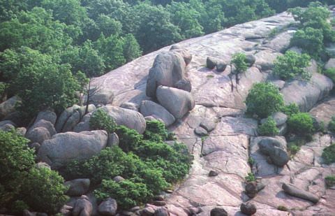
DNR photo by Jerry D. Vineyard and David Hoffman
Aerial view of Elephant Rocks State Park.
Igneous Rocks
The Volcanic Stone of Missouri
The St. Francois Mountains The igneous rocks are core and granite in the St. Francois
of southeast Missouri are known features in some of Missouri’s Mountains led to the develop-
for their exposures of 1.5 to 1.2 most spectacular scenery and ment of settlements and towns,
billion year old igneous rocks. popular state parks, including and was often the impetus behind
These exposures are remarkably Johnson’s Shut-Ins, Elephant the development of infrastructure
fresh and unaltered, and are Rocks and Taum Sauk Mountain. in the region. Today, this region is
unique within the mid-continent Each of these parks owes its still a major producer of mineral
region of the United States. The unique character to the igne- products.
area also gives a rare glimpse ous rocks and to the geologic
into rocks that are formed by the processes that have formed and
most violent volcanic eruptions shaped them.
known on the earth. Consequently, The rocks have also provided
geologists come from around the a livelihood for generations of MISSOURI
DEPARTMENT OF NATURAL RESOURCES
world to study them. Missourians. Early mining of iron Division of Geology and Land Survey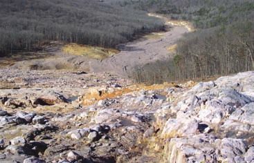
Missouri’s Volcanic Past                                                                         Granites and
    Approximately 1.4 billion years
ago, southeast Missouri was a land-
scape dominated by volcanic calderas,
                                           the more viscous, or thick, will be the
                                           lava. Viscous magmas tend to hold
                                           more volcanic gas and therefore erupt
                                                                                                 Rhyolites
some of which were up to 15 miles in       explosively. Rhyolite calderas produce                   Granite is the most common
diameter. These calderas were different    the most violent eruptions of any type of             igneous rock type at depth in Mis-
from volcanoes active today in places      volcano on earth.                                     souri, but it makes up very little of
like Hawaii. Instead, they more closely                                                          the exposed rock in the St. Francois
resembled the Yellowstone caldera,
                                           Formation of a Caldera Volcano                        Mountains. Most of the outcrops are
which today, is the largest dormant        Volcanic Eruption Pre-existing rock is                a volcanic rock called rhyolite. While
                                                                  pushed upward and              the two rocks look very different, they
volcano in the United States. Unlike      Rhyolite                fractured by magma
“typical” volcanoes, calderas do not                                                             have essentially the same chemical
                                                                  in the chamber below.
erupt from one main vent or develop a                                                            composition and are made up of the
                                                                  Rhyolite ash and lava
large cone-shaped mountain. Instead,              MAGMA           erupt to the surface.          same minerals. Granite was formed
magma (molten rock) from an underlying                                                                        from magma that never
                                           Volcanic Collapse                                                      reached the surface.
chamber moves upward under pressure                               After eruptions, the
and erupts lava from multiple vents in a                                                                              Because it cooled
                                                                  overlying rocks collapse
series of smaller eruptions. Over time,                           into the mostly emptied                               slowly under-
the pressure in the magma chamber                  MAGMA          magma chamber.                                          ground, it had
                                                                                                                           time to de-
builds to the point that the overlying     Erosion
rock cannot withstand the pressure and                            As the caldera becomes
                                                                                                                             velop large
a giant eruption occurs, forming a crater                         extinct, remaining magma                                         crystals
miles in diameter. Layers of volcanic                             cools into granite.                                                  of
                                                   GRANITE        Overlying igneous rocks
rock form thousands of feet thick.                                slowly begin to erode.
                                                                                                 Close-up of Missouri red granite
    Large calderas such as these gener-
ally erupt rhyolite (see Granites and      Today                                                 the minerals quartz, feldspar and
Rhyolites), a volcanic rock that is very                                                         mica. Rhyolite, on the other hand,
                                                                  The rhyolite has eroded,       erupted from a volcano, cooling so
high in silica, a compound comprised                              exposing the large granite
of the elements silicon and oxygen.                                                              fast that the lava did not
                                                   GRANITE        body at the surface. The
The higher the silica content in a magma,                         harder rhyolite forms knobs.   have time to grow
                                                                                                 large crystals.
                                                                                                 Most of the
  Lava vs. Ash                                                                                   crystals that
                                                                                                 make up
      When many people think of volcanic eruptions, they picture lava flows.                     rhyolite
  While some of the volcanic rocks in Missouri are lava flows, most of them are a                are
  type called ash flow tuffs, similar to those formed by the Mt. St. Helens erup-                so          Close-up of Missouri rhyolite
  tions in the early 1980s. Ash-flows occur when the lava explodes so forcibly that
  it comes out in small droplets that immediately harden into fi ne, gritty pieces               small that one needs a microscope
  of rock, called volcanic ash. The ash is mixed with hot volcanic gases that are                to see them.
  also part of the eruption. This mixture of ash and hot gases flows like a liquid                   Because the mineral grains are
  down the side of the volcano, and is called a pyroclastic flow. Pyroclastic flows              larger, granite in the St. Francois
  can move at speeds of up to 100 miles per hour, and may be near 1,800 degrees                  Mountains weathers and erodes
  Fahrenheit. The ash is so hot that it welds together when it falls to the ground,              faster than rhyolite. Therefore, areas
  forming a solid rock. This is the type of eruption that destroyed the Roman                    with granite bedrock are often very
  cities of Pompeii and Herculaneum, except that the eruptions from Missouri’s                   low knobs or lowlands. Rhyolite is
  volcanoes are estimated to have been more than 100 times larger.                               much more resistant to weathering,
      Other volcanic rocks in Missouri are called ash-fall tuffs. These igneous rocks            and makes up most of the steep,
  form when smaller eruptions occur. The volcanic ash is blown up into the air, but              high knobs that form the St. Francois
  does not contain as much volcanic gas as when a pyroclastic flow is unleashed.                 Mountains.
  The ash falls to the ground, or is blown by winds before being deposited. Volcanic                 Other igneous rocks found in
  ash that is blown high into the atmosphere can go around the Earth several                     the St. Francois Mountains include
  times before it settles to the ground.                                                         trachyte, diorite and syenite. These
                                                                                                 look very much like rhyolite, except
   Pyroclastic Flow                                            Pyroclastic Flow                  they are black or near black in color.
                                                                                                 They contain less quartz and feldspar
                                                                                                 than rhyolite, and more minerals that
                                                                                                 are dark in color that contain high
                                                                                                 amounts of iron and magnesium. They
                                                                                                 are exposed in only a few places, but
                                                                                                 weather (and form knobs) like rhyolite.
                                                                                                                                              2
A Moment in Time
          Iron Mountain is located in St. Fran-     the M.A. Hanna Company made the de-                      date, the company began processing
      cois County and was originally given in       cision to cease iron mining operations                   piles of unmineralized igneous rock,
      1797 to James Pratt, a settler of great       at the site. Several years before this                   called waste rock, which was left over
      influence in the Upper Louisiana                                                                                from the iron mining for use as
      territory, as part of a land grant                                                                              aggregate, or crushed stone.
      by the Spanish government.                                                                                      Today, the site still produces
      At the time, the mountain was                                                                                   igneous rock once considered
      believed to be entirely iron ore. In                                                                            waste from the mining opera-
      1836, the property was conveyed                                                                                 tion as aggregate, making it
     to the Missouri Iron Company,                                                                                    the oldest continually mined

                                                                                                                 DNR photo by Art Hebrank
     which began mining the site. The                                                                                 property in the United States.
     first mining was of ore exposed at                                                                               The hoist for the underground
     the surface, but operations soon                                                                                 workings and many of the origi-
     changed to underground mining.                                                                                   nal buildings remain on the
     Iron Mountain was mined almost                                                                                   site, preserved by the current
     continuously by various compa-         Headframe, buildings and water tanks from the Iron Mountain mine, which and past operators as a living
     nies from 1836 until 1966, when        began mining in 1836.                                                     piece of Missouri’s history.

    St. Francois Mountains                                                      Young and Old
         The history of the St. Francois Mountains began when                      When rocks are removed by erosion and the erosional
    repeated rhyolite ash-flows, ash-falls and lava eruptions                   surface is then covered by younger rocks, unconformities
    cooled and solidified on the surface. This process lasted for               occur. Unconformities represent gaps in the geologic record
    at least several hundred million years. When the magma                      similar to pages missing from the middle of a book.
    chambers emptied after large eruptions, the overlying rock                     In the St. Francois Mountains, there are numerous places
    would fracture and collapse. Large blocks of rhyolite would                 where a person’s hand can span rocks that bracket 900
    tilt and slip against one another. Magma chambers refi lled                 million years of missing geology — a period of time that rep-
    and the calderas erupted many times. At the same time,                      resents more than one-fifth of the geologic history of the Earth.
    granites intruded into the pre-existing rock and solidified                    Fossils are often useful indicators of the age of rocks.
    below the surface. The total thickness of the granite and                   Igneous rocks, however, do not contain fossils, because they
    rhyolite sequence is not known, but is easily tens of thou-                                                                              either formed deep
                                                                                     Sea with knobs forming islands
    sands of feet.                                                                                                                           underground or
         Eventually, the underlying magma cooled and the calde-                                                                              were too hot for
    ras became inactive. The igneous rocks eroded, forming a                                                                                 any life to survive
    mountainous topography. Geologists estimate that as much                                                                                 their placement on
    as 6,000 feet of igneous rock may have been eroded to form                     After eruptions stopped, igneous rocks and calderas       the earth’s surface.
    the range of knobs and hills that we call the St. Francois                     eroded into a series of knobs or mountains.               Instead, radioactive
    Mountains. The calderas themselves were also eroded, so                                     Sedimentary rock                             isotopes are used
    that today we see only the roots of the once giant calderas.                                                                             to date igneous
         Roughly 520 million years ago, the Ozark region was                                                                                 rocks. Radioactive
                                                                                               Around 530 million years ago
    lowered due to continental movement. Seas inundated the                                                                                 elements, such as
    area and began to deposit sedimentary rocks — fi rst beach-                    The seas inundated the area, depositing conglomer-       uranium, naturally
    like deposits of sandstone and then limestone and dolomite.                    ates and sandstone, then limestone and dolomite.         decay. This decay
                                                                                   The gap in time between the igneous rocks forming
    The seas advanced and retreated many times, burying the                        and the conglomerate is our great unconformity.          occurs at a known
    St. Francois Mountains under layers of sediment that lith-                                   Sedimentary rock                           rate. Geologists
    ified, or hardened, into sedimentary rocks.                                                                                             fi nd the percent-
         Recently, in geologic terms, the Ozark region has been                                                                             age of atoms that
    uplifted due to pressure on the tectonic plate that carries the                                                                         have experienced
    North American continent. The uplift led to increased ero-                                                                              decay and use this
    sion, removing the sedimentary rocks from the core of the                      Sedimentary rocks continued to be deposited as the       as a clock to tell
    St. Francois Mountains. The same rugged topography that                        seas came and went. The knobs were likely, com-          how long it has been
                                                                                   pletely covered by sedimentary rocks.
    we see exposed in just a few counties in southeast Missouri                                                                             since the rock formed.
    lies buried under hundreds to thousands of feet of sedimentary                                                        Knobs             This is how we know
    rock throughout the Ozarks. As the area continues to be                                                                                 that the igneous
    slowly uplifted, more of the buried mountain range will be                                                                              rocks in the St.
    exposed at the surface.                                                                                                                 Francois Mountains
                                                                                   The seas retreated for the last time and the sedimentary are 1.5 to 1.2 billion
                                                                                   rock eroded, exposing the knobs. The erosion occurred
                                                                                   because this area of Missouri was being uplifted.        years old.
3
Elephant Rocks Minerals and Mining
The granite boulders in Elephant The unique geology in the St. souri until 2001, when Pea Ridge,
Rocks State Park are not only beautiful Francois Mountains led to the forma- the last operating underground iron
and enjoyable, but are also a textbook tion of numerous mineral deposits. mine in the United States, ceased
example of weathering granite. The The location of the deposits, in turn, production. The mine is located ap-
granite formed thousands of feet below affected settlement proximately 16 miles
the surface, but has been uplifted and in the area and the Granite has a long history of use as southeast of the town
exposed by erosion. Cracks formed in area’s history. Names a building stone, and is found in houses of Sullivan. Iron from
the granite when it cooled, and stresses like Ironton, Iron Pea Ridge was used
caused by the uplift led to greater frac- around the state and in buildings from
Mountain and for steel production,
turing of the rock. When the granite was Graniteville reflect the California to Massachusetts. coal desulfurization,
exposed at the surface, water and ice mineral products around which high-density concrete
began to widen the fractures and erode those communities were founded. and iron pigments. Large reserves of
the granite. The granite at the surface Metals like iron, copper and manganese high-grade iron ore still remain under-
became a series of oblong blocks. The and stone products from rhyolite and ground in Missouri’s igneous rocks,
corners and edges of the blocks became granite have been produced from this giving the state the potential to return
rounded due to weathering and chemi- region for centuries. to a position as a major iron producer.
cal reactions of the rock with water Iron was the
and air. Eventually, the rounded blocks primary mineral
became the huge isolated boulders, commodity
or “elephants,” that are sitting on the produced from
granite outcrop. igneous rocks.
The basins, often called “birdbaths,” The exposed St.
that are near the “elephants” were origi-
Francois Moun-
nally shallow depressions that could
tains, as well as the
accumulate
igneous rocks still
water. The
buried beneath
combined
the sedimentary
chemical
rocks, host a
reaction
world class iron
DNR photo
between the
granite and ore district. Iron
DNR photo by Bill Duley
the water, metal was fi rst
as well as produced in 1815, An example of a granite quarry, near Graniteville.
continual when surface
freezing and veins of magnetite (iron oxide) were Granites and rhyolites are also
thawing, mined on Shepherd Mountain, near mineral commodities produced in
continues Numerous birdbaths in the granite at Ironton. The surface iron mines at Missouri. Missouri granite has a long
Elephant Rocks State Park. Iron Mountain and Pilot Knob were history of use as a building stone, and
to cause
the granite to fragment and weather, also developed in the fi rst half of the is found in houses around the state
gradually deepening and 19th century. The fi rst iron furnace and in buildings from California to
widening the basins. west of the Mississippi River was con- Massachusetts. Graniteville granite,
structed near Ironton at this time as found at and near Elephant Rocks
well. The iron was shipped by wagon State Park, was used extensively in St.
to St. Louis and other river ports. This Louis for cobblestone streets, build-
Rock Types eventually proved too costly, and led
to construction of the St. Louis and
Iron Mountain Railroad, completed
ings at Washington University and
for Eads Bridge. Graniteville granite
is also in the Illinois and Iowa state-
All rocks found on and in the
in 1858. It later became the Missouri houses and the Missouri Governor’s
earth can be divided into three
Pacific Railroad, one of the major rail Mansion. Rhyolite is also quarried, and
main types. Igneous rocks are
systems in the nation. today, is used to make the granules
rocks that form by the cooling and
Iron production continued in Mis- found on roofi ng shingles.
solidification of molten rock. Sedi-
mentary rocks like limestone and
sandstone form either by precipita-
tion from water or by the erosion of
other rocks and redeposition and
cementing of the eroded grains.
Metamorphic rocks, which are rare
in Missouri, form when the minerals
and textures of a rock are changed
by extreme heat or pressure. Igneous rock Sedimentary rock Metamorphic rock
4Fascinating Geology Revealed
In December 2005, a hydropower geologists, geology students and to New geologic drill hole information was
reservoir facility located on top of Prof- anyone interested in the geologic collected and used in conjunction with
fit Mountain in rural Reynolds County history of this unique region. archived data. Support was also provided
failed. The event affected Johnson’s The division has supported efforts for assessment and repair of the environ-
Shut-Ins State Park and water quality to understand the failure mechanism mental damage related to the event. The
and aquatic habitat in the East Fork for the reservoir and the geologic and division has also provided geologic ex-
of the Black River as well as in down- geophysical limitations for the safe pertise for interpretative displays within
stream sections of the Black River. rebuild of a new pumped storage facility. Johnson’s Shut-Ins State Park.
The flood scar revealed a dramatic
exposure of the igneous and sedimen-
tary bedrock that make up the west
flank of Proffit Mountain. The hillside
provides a unique geologic workshop
for current and future generations of
The flood scar is slightly more than 1.5 miles in length
from the reservoir to the former bed of the East Fork of
the Black River. The flood scar left behind after approximately 1.3 billion gallons of water rushed down the side of the Proffit
Mountain, exposing igneous bedrock.
Archiving Geologic Data
A mission of the Div ision of vary from surficial ronmental studies,
Geology and Land Survey is to archive materials collected and academic
geologic data of different types and to for earthquake haz- purposes. Core
make this information available for ard and glacial mate- samples are an im-
inspection by geologic professionals rial studies to deep drill portant scientific and
and the public. The division archives cores that enhance our un- economic resource that
include everything from paper derstanding of the igneous rocks would be very expensive or
information to rock samples. The that are buried under thick layers of impossible to duplicate. Maintaining a
McCracken Core Library contains sedimentary rock. The drill cores are core library greatly increases the de-
more than 2.5 million feet of drill core used to explore for ore deposits, for partment’s ability to provide technical
from around the state. The drill cores geologic mapping, hydrologic and envi- assistance and geologic information
to those who develop, market, manage
or regulate the state’s energy, land,
and water resources.
The Division also archives infor-
mation about past mining activity in
DNR photo by Mark Gordon
Missouri. Part of this archive contains
historic mine maps. The maps show
surface and underground mines that
produced commodities including:
iron, lead, zinc, limestone and
sandstone, among others.
5Web Sites
Taum Sauk State Park Elephant Rocks State Park
www.mostateparks.com/taumsauk.htm www.mostateparks.com/elephantrock.htm
Published by the
Johnson’s Shut-Ins State Park Elephant Rocks Fact Sheet
www.mostateparks.com/jshutins.htm www.dnr.mo.gov/pubs/pub683.pdf Missouri Department
of Natural Resources
Division of Geology
Publications and Land Sur vey
RI-64. Geology of the Precambrian St. Francois Terrane, Southeastern Missouri, (Contribu-
tion to Precambrian Geology No. 8), by Eva B. Kisvarsanyi, 58 p., 9 figs., 10 tbls., 1:250,000-scale map,
Joe Gillman
Director and State Geologist
1981. Division of Geology and Land Survey
RI-67. Guidebook to the Geology and Ore Deposits of the St. Francois Mountains,
Missouri, (Contribution to Precambrian Geology No. 9), by Eva B. Kisvarsanyi, Arthur W. Hebrank, Bill Duley
and Richard F. Ryan, 119 p., 75 figs., 8 tbls., 1981. Deputy Director and
Assistant State Geologist
OFM-83-160-MR. Geologic Map of Exposed Precambrian Rocks in the Iron Mountain Division of Geology and Land Survey
Lake Quadrangle, Missouri, www.dnr.mo.gov/geology/sitemap/rolla/ro8301.htm
OFM-83-161-MR. Geologic Map of Exposed Precambrian Rocks in the Wachita Mountain
Cher yl Seeger
Contributing Author
(Fredericktown NW¼) Quadrangle, Missouri, (Contribution to Precambrian Geology No. 11), by
M.E. Bickford and J.R. Sides, 1:24,000
Hylan Beydler
OFM-83-162-MR. Geologic Map of Exposed Precambrian Rocks in the Lake Killarney Division Information Officer
Quadrangle, Missouri, (Contribution to Precambrian Geology No. 12), by J.R. Sides, 1:24,000.
Mark Gordon
These and other publications may be purchased from the Missouri Department of Natural Resources’ Layout and Graphics
Division of Geology and Land Survey. To order, contact the publications desk at: 573-368-2125 or
1-800-361-4827, or use our online form at: www.dnr.mo.gov/geology/adm/publications/MapsOrder.
htm. For additional information visit our Web site: www.dnr.mo.gov/geology/.
MISSOURI DEPARTMENT OF NATURAL RESOURCES PRSRT. STD.
Division of Geology and Land Survey U.S. POSTAGE
P.O. Box 250, Rolla, MO 65402-0250 PAID
PERMIT #215
ROLLA, MO
O F MISSOURI
6You can also read