Mapless Navigation: Learning UAVs Motion for Exploration of Unknown Environments
←
→
Page content transcription
If your browser does not render page correctly, please read the page content below
Mapless Navigation: Learning UAVs Motion for
                                                                   Exploration of Unknown Environments
                                                                                  Sunggoo Jung1 and David Hyunchul Shim2

                                           Abstract— This study presents a new methodology for
                                        learning-based motion planning for autonomous exploration
                                        using aerial robots. Through the reinforcement learning method
                                        of learning through trial and error, the action policy is derived
                                        that can guide autonomous exploration of underground and
                                        tunnel environments. A new Markov decision process state is
arXiv:2110.01747v1 [cs.RO] 4 Oct 2021

                                        designed to learn the robot’s action policy by using simulation
                                        only, and the results is applied to the real-world environment
                                        without further learning. Reduce the need for precision map
                                        in grid-based path planner and achieve map-less navigation.
                                        The proposed method can have a path with less computing
                                        cost than the grid-based planner but has similar performance.
                                        The trained action policy is broadly evaluated in both sim-
                                        ulation and field trials related to autonomous exploration of
                                        underground mines or indoor spaces.                                      Fig. 1.    A snapshot of autonomous flight using propose DRL based
                                                                                                                 exploration framework in a real-world environment

                                                             I. INTRODUCTION
                                           As powerful computations become possible on small com-                area of exploration increases [6].
                                        puters, there is a growing demand to combine them with                   To address these issues, we propose a mapless autonomous
                                        drones to explore areas that are difficult for humans to reach           exploration based on deep reinforcement learning (DRL),
                                        [1], [2]. Following this trend, the DARPA Subterranean Chal-             a novel motion planning algorithm that exploits LiDAR
                                        lenge requires robotic agents to explore various underground             measurements to recognize the spatial data of the surrounded
                                        spaces ridden with obstacles to find a set of objects including          environment around the aerial robot. Define the status of
                                        human victims for rescue. Such a mission will require drones             the Markov decision process (MDP) using the ambient data
                                        to find its location and a collision-free path in real-time              of the LiDAR point cloud, the current pose of vehicle and
                                        using local maps built on the fly. Autonomous exploration in             the target location to be reached. The proposed framework
                                        these environments poses a series of challenging problems                can bridge the reality gap between synthetic simulations
                                        at many levels. GPS signals may not be available [3], and                and physical robots. Without further learning, the results of
                                        may be a condition in which only limited lighting exists [4].            the policies learned in the simulation can be applied to the
                                        In addition, flight between narrow gaps and low heights of               real-world environment and it shows performance similar to
                                        the ceiling may be required [5].                                         traditional grid-based planning with less computing power.
                                        In general, method for autonomous exploration in unknown                 The main contributions of this paper are:
                                        and cluttered environments using aerial robots is as follows:               • We propose a DRL based autonomous exploration ap-
                                        1) generate a map of the surrounding environment from                         proach by utilizing a new MDP state which can allow
                                        gathered sensor information; 2) convert the generated map                     us to use the simulation learning results directly in an
                                        into a path plan-appropriate format such as a Probability grid;               real-world experiment without further learning
                                        3) applying path planning techniques such as A* or RRT*;                    • We newly use collision-free open space end-point selec-
                                        4) extract waypoint from generated path; 5) generate control                  tion of a local segment path to take an obstacle-aware
                                        command to track the waypoint information. However, prob-                     motion planning
                                        lem of the traditional autonomous exploration approach is                   • Demonstration of the proposed method in a fully on-
                                        that the key exploration strategy depends heavily on precise                  board quadrotor system. We evaluate the DRL result
                                        maps, so the computational burden increases rapidly as the                    on both simulation and real-world by traversing a large
                                                                                                                      building and subterranean environment
                                           This paper is based upon work supported by the Ministry of Trade,
                                        Industry & Energy (MOTIE, Korea) under the Industrial Technology Inno-                      II. RELATED WORK
                                        vation Program. No.10067202, ”Development of Disaster Response Robot
                                        system for lifesaving and Supporting Fire Fighters at Complex Disaster      Various approaches for autonomous exploration of an
                                        Environment”                                                             unknown area using UAVs have been proposed and im-
                                           1 Sunggoo Jung is with the Autonomous UAV Research Section, ETRI,
                                                                                                                 plemented [7], [8], [9]. Early work includes frontiers-based
                                        Daejeon, Korea. sunggoo@etri.re.kr
                                           2 David Hyunchul Shim is with the Unmanned Systems Research Group     exploration [10], model predictive control (MPC) based path
                                        (USRG), KAIST, Daejeon, Korea. hcshim@kaist.ac.kr                        re-planning experimental work [11] also presented. Herein,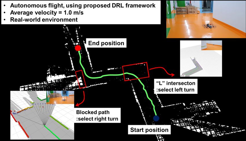
we provide a brief overview of state-of-the-art contributions
that are especially relevant to exploring unknown/unexplored
area using UAVs.
A. Online Path Re-planning of UAVs
Unknown area exploration planner was proposed by [12].
This work successfully shows the capability of priory un-
known area exploration while collision avoidance. Kino-
dynamic real-time planning using quadrotor is presented in
[13]. This shows full-stack, planning architecture, however
the state-estimation is relay on the VICON motion capture
system. Front-end path planning and back-end path smooth-
ing works have proposed in [14] and show impressive results
in a small range of indoor and outdoor area. MPC based
Fig. 2. a) Conceptual figure of end-point selection from LiDAR range
online path planning work show dynamic re-planning with measurements. Evenly 48 point cloud is sampled around the vehicle. b)
considering multi-object concept [15], however the work Example of a Gazebo simulation showing that a local goal is being selected
finished within simulation without real-world validation. in real time, depending on the current state of the vehicle.
One line segment combination path smoothing approach is
presented in [16]. This work generates the path using a
two-point boundary value problem approach to reduce the 2) In order to use the learned policy under simulation
computation cost. This work showed reliable flight result, directly into the real environment, we define the MPD
however, the piece-wise segment of path joint optimization state with superior generalization.
is not presented. Interesting works is presented by [17]. In 3) Map the learned motion to the high-level Velocity
this work, they developed an online path planning algorithm controller of the robot so that it is not related to the
to reduce the energy cost while detecting the weeds. They dynamics of the actual robot.
showed impressively reducing the energy cost by effective IV. METHODOLOGY
path planning algorithm but still also remain in simulation.
The MDP state is designed to use TD advantageous actor-
B. DRL based exploration critic (A2C) reinforcement learning framework for unknown
Due to the recent significant development of DRL, re- area exploration [23], [24]. Initialize state s0 according to
searchers in the robot control area have tried many studies the initial condition. Based on the initial state and policy,
linking generated policy from DRL results to robot control. the algorithm selects the control action a0 ∈ A (A is action
Modular network is used for Successful Robot navigation space and there are eight actions in total which is called
[18], [19]. However, these methods simply focus on flying king’s move). As a result of the selection, the system ran-
without collisions. For autonomous exploration, [20] com- domly transitions to any new state sk and receives a reward
ak−1
bine traditional navigation approaches with DRL-based de- according to the state transition probability Psk−1 (). The main
cision algorithm and design additional segmentation network purpose of RL in this paper is to update policy through the
architecture. [21] integrates DRL with frontier exploration. MDP information to find the optimal collision-free path from
While these methods demonstrate successful exploration current position to local-goal.
performance in cluttered area, gridding map information A. Local-goal selection
must always be exist. [22] propose imitation learning from
traditional graph-based planner. Although it showed good The LiDAR sensor measurements give the index and
performance, it requires further learning in the real world. distance of the point which can be denoted by [k, lk ]. To
select local-goal, we sample evenly 48 points out of 1440
III. PROBLEM STATEMENT LiDAR point clouds. The samples are at 30 intervals starting
The DRL-based end-to-end control method has the advan- from the 1st index of the LiDAR among a total of 1440
tage of being concise, but it requires a large trial and error LiDAR points(see, Fig. 2). This constitutes a set of 48 sample
experience. Therefore, this learning is generally done in the point clouds surrounding the vehicle at 270 degrees. Now,
simulation environment. However, due to the reality-gap, it is we collect a set of point clouds exceed a certain distance dth
difficult to bring the results learned from the simulation into (local-goal candidates, First line of Eq. 1). Find the average
the real-world. Based on these issues, the following methods index of this set and convert the point cloud of the average
are used in this paper. index to the body-frame coordinate system. Finally we define
the converted point as local-goal (Eq. 2.)
1) Improve learning convergence by replacing navigation
with the problem of planning a short-distance path
4m − wψ i f σk = ∞, or σk >= dth
from your current location to a selected local goal. This
Lk = 3m − wψ i f 3m ≤ σk ≤ dth , (1)
local-goal is planned as a receding horizon planning
strategy to expand the exploration area.
σk otherwise,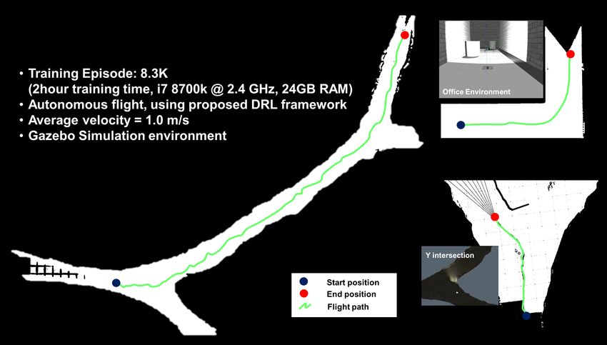
the vehicle’s current position in blue, and the target position,
which is the local target that the agent to be reached, is
marked in red. This eliminates the synthetic error of sensor
information, reducing the gap with the real-world. The agent
ground shown in this way is used as the input to CNN.
Through this, feature points is extracted and used these result
as an actor-critic input.
C. Reward function: for collision-free exploration
Creating the shortest path is important to efficiently
explore unknown environments, but creating collision-free
paths is more important. The reward function is designed as
10 (p(x1 , y1 ) = g(x, y))
(p(x1 ,y1 )6=g(x,y))
r = |l prev | − |l| (3)
(p(x1 ,y1 )6=o(x,y))
−100 (p(x1 , y1 ) = o(x, y))
where p is the current position, g is a local-goal, and o
represents ans obstacle which is colored in black in agent
ground. If agent is not in both local goal and obstacle the
reward is given by the temporal difference. Where l is the
euclidean distance from agent position to local-goal. Through
this reward function, the agent gradually learns how to reach
the target point with the best path while avoiding obstacles
as learning progresses to maximize cumulative reward.
V. T HE N EURAL N ETWORK IN TD ACTOR -C RITIC
Fig. 3. The agent ground and designed MDP states. State is configured
LiDAR point cloud (black dots), vehicle current pose (blue dot), and local- The components of MDP is a tuple (S, s0 , A, Psa , γ, R).
goal (red dot) In this paper, S = {sk }k=1,...,k, sk ∈ R2 is the set of states
including position of each lidar point cloud, current position
of a drone and target point location. The network architecture
cos(ψ + k · Ω Ω
N − 2)
setb∗k = argmax x + Lk · (2) builds along the same lines as TD Actor-Critic [24] which
k∈N sin(ψ + k · Ω Ω
N − 2) minimize the gradient:
where wψ is weight term to select index which is most ∇θ J(θ ) = Eπθ [∇θ logπθ (s, a)δ πθ ] (4)
perpendicular to the vehicle heading. Vehicle current position
x, heading ψ, and the sampled LiDAR point cloud pose where E[·] denotes the expected value, s is the state in the
L = {lk }k=1,...,K , lk ∈ R2 is in vehicle body-frame coordinate. state space S, a is the action in the action space A and δ is
Ω is the sample field of view, and N is total number of the temporal difference error.
samples. The selected b∗k is defined as the local-goal.
A. Training
B. MDP state design: narrowing the reality gap Training is performed in gazebo simulation environment.
Methods for learning control commands has a disadvan- The sensor set and the size of a vehicle can be configured
tage that the network becomes large because an encoder similar to the real world robot. As shown in Fig. 3, the
and a decoder must be used. Instead of learning the control objective of this training step is to move the blue dot agent
command directly, we generalize the sensor data and replace to the red dot local-goal. The black point is an obstacle, so if
it with the problem of learning the action in grid world. the agent reaches it, it will be penalized. Therefore, the agent
We configure the space for the agent to learn. The local must reach the red dot while avoiding obstacles to maximize
search space with a grid of 10cm in the space of 10m × the reward. Because the agent ground is configured with a
10m of the real-world is set as the agent ground (see Fig. resolution of 10cm, the local-goal from the agent is located
3 (a)). On this agent ground the LiDAR point cloud, the 40 pixels ahead of the agent. The maximum number of steps
current position of an agent, and the target position is stored per episode is set to 200 steps, and when the agent reached
in the form of world coordinates. Therefore, the RL problem the target or obstacle, the episode is immediately terminated,
becomes a path-planning problem from current pose to local- rewarded, and initialized to a new episode.
goal in 100pixels × 100pixels grid world (see Fig. 3 (b),(c)). Fig. 4 shows the overall training framework in block dia-
The left image shows the flight environment. Right image is gram representation which is following advantage actor-critic
the agent ground. It includes the LiDAR point in black color, (A2C) algorithm Flow.
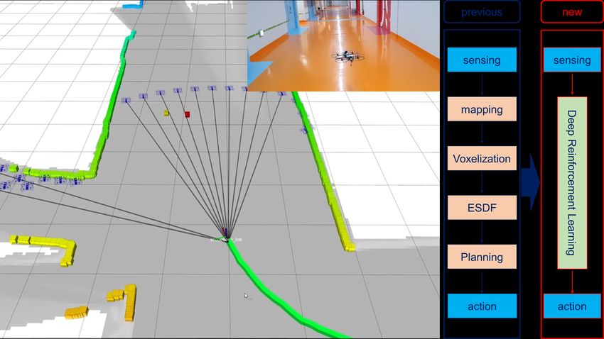
Fig. 6.    System overview of our DRL-based autonomous exploration
                                                                               aerial vehicle. Occupancy grid is obtained upon an existing open-source
                                                                               implementation [26] for indoor localization purpose only
Fig. 4. Overall training algorithm flow of proposed DRL based exploration
scheme.

                                                                               Fig. 7. DRL-based autonomous exploration in simulation environment. The
                                                                               explored path shows well trained result by successfully avoiding collision
                                                                               with obstacles/walls

                                                                                                       VI. EVALUATION
                                                                               A. Simulation
                                                                                  In order to evaluate the DRL-based autonomous motion
                                                                               planner, Various simulation environments is configured. For
                                                                               flight testing, the overall software architecture, including
                                                                               DRL techniques, is represented in Fig. 6.
Fig. 5. Training result of non-curriculum/curriculum learning. The intro-      Fig. 7 shows DRL-based motion planner result in various
duction of curriculum learning confirms that the rewards and losses converge
correctly
                                                                               simulation environments such as ”L” shaped office environ-
                                                                               ment, ”Y” intersection and large-scale underground mines.
                                                                               In each environment, the proposed motion planner fly stably
                                                                               without collision. The exploration was expanded by the re-
B. Curriculum Learning
                                                                               ceding Horizon method while maintaining a constant interval
   If a local goal is placed far from the start at a time                      from the current location of the Vehicle to the local-goal,
when no learning has been made, for example, aiming at                         resulting in successful flights of more than 200 meters in
a distance of 4 meters from the current position of the                        the underground mine simulation environment. Additionally
vehicle, the agent must take at least 40 consecutive successful                we compare computing costs of the traditional A*+ESDF
actions to reach the local-goal. As a result of learning in this               planner and the proposed DRL-based motion planner. The
condition, the agent cannot reach the local-goal within the                    traditional method is map-based navigation method, which
limited 200 steps. Accordingly, in order to somehow end                        produces grid-map from sensor information. After voxelizing
the episode, the learning parameters were converged toward                     it, the path is planned and the action is finally derived.
terminating the episode by hit the wall/obstacle (see Fig.                     On the other hand, the proposed DRL-based framework is
5-Non curriculum learning). Thus, to solve this problem,                       a mapless-navigation method in which the action is derived
the method of curriculum learning [25] is introduced. We                       immediately after the sensor information passes through the
set a goal of 2m distance up to the first 500 episodes, and                    DRL-network. At this time, we decouple the action and
learned 3m and 4m local goals for the rest of the training                     control to reduce synthetic error caused by the dynamic
until 1500 episodes. The effects of curriculum learning were                   effect of the system. Instead, we linked action with the
shown in Fig. 5-Curriculum learning. Policy loss, value loss                   Velocity command so that the results learned in simulation
and reward have been converging consistently as episodes                       could be used directly for real-world regardless of low-
increases.                                                                     level dynamics of the actual robot. According to Fig. 8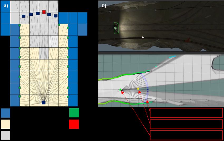
the current position to the goal was designed as a reward. It
                                                                          is designed to receive a reward of + when the agent moves
                                                                          closer to the goal and - when the agent moves away.
                                                                          We first tried to learn in this way, but the values of rewards
                                                                          and total steps did not converge easily. Thus, the method of
                                                                          curriculum learning was introduced. The curriculum learning
                                                                          method is also called self-paced learning as a way to teach
                                                                          from easy methods step by step so that more difficult
                                                                          problems can be solved. The position of the target point
                                                                          that the agent had to reach increased from 2m to 5m as the
                                                                          episode increased, resulting in a successful learning result.
                                                                          These learning results were first validated in gazebo simu-
Fig. 8. Comparison of computing cost between grid-based planning method
and newly adopted DRL based motion planner. The proposed DRL-based
                                                                          lations. The reason for choosing gazebo as the simulation
planner consumes almost half of the energy of traditional path planner    environment was useful for this high-level control study
                                                                          because it could use the same controller of the px4 stack used
                                                                          as the low-level controller of the aerial-robot. Also, sensor
the CPU consumption rate decreased by about 50% and                       data are highly correlated so that simulation results can be
the total number of packages running decreased by about                   easily applied as real-world. Through Gazbo simulation, we
40% compared to the traditional method. This indicates that               conducted learning in office environment, straight course
the end-to-end method, the DRL technique, is more energy                  environment, and subterranean environment. As a result of
efficient than the traditional method.                                    deploying the learned policy, it is possible to successfully
                                                                          explore the unknown environment. These are applied directly
B. Real-world evaluation                                                  to the real-world without further learning. The flight test is
   Our system is a 350-size frame with the DJI Snail rac-                 conducted in the basement of KAIST’s KI building and is
ing drone propulsion system, which can lift all the sensor                very successful in exploratory flights.
systems required for autonomous exploration purpose and                   In this paper, we use 2D LiDAR point cloud. In other
fly as long as twelve minutes. We chose the Px4 autopilot                 words, we do the motion plan using only point cloud that
for low-level flight control, and NVIDIA Jetson TX2 GPU                   is projected to a horizontal plane. For Future work, we plan
for high-level mission management. The TX2 module is                      to use three-dimensional LiDAR to project point cloud into
mounted on a third-party carrier board (Auvidea J120). For                a vertical plane and create another DRL module to plan the
altitude measurement, the drone is equipped with a Terabee                motion in vertical plane also to focus on solving the Full-3d
TeraRanger-Evo one-dimensional LiDAR. The 2D SLAM                         problem.
and the altitude information are sent to the Extended Kalman
Filter (EKF) running on the NVIDIA Jetson TX2 to compute                                               R EFERENCES
more accurate state estimation by fusing with Microstrain                  [1] A. Bircher, M. Kamel, K. Alexis, M. Burri, P. Oettershagen, S. Omari,
3DM-GX4-25 Inertial Measurement Unit (IMU).                                    T. Mantel, and R. Siegwart, “Three-dimensional coverage path plan-
                                                                               ning via viewpoint resampling and tour optimization for aerial robots,”
Fig. 9 shows the navigation of unexplored corridors using the                  Autonomous Robots, vol. 40, no. 6, pp. 1059–1078, 2016.
proposed MDP state generalization and local-goal selection                 [2] H. Shakhatreh, A. H. Sawalmeh, A. Al-Fuqaha, Z. Dou, E. Almaita,
methods. In the corridor environment consisting of a straight                  I. Khalil, N. S. Othman, A. Khreishah, and M. Guizani, “Unmanned
                                                                               aerial vehicles (uavs): A survey on civil applications and key research
section and a corner section of varying width, it can be                       challenges,” Ieee Access, vol. 7, pp. 48 572–48 634, 2019.
confirmed that the flight is successfully performed by the                 [3] C. Papachristos, S. Khattak, F. Mascarich, and K. Alexis, “Au-
proposed method. The path is also created in the middle                        tonomous navigation and mapping in underground mines using aerial
of the corridor, showing the robot moved properly to the                       robots,” in 2019 IEEE Aerospace Conference. IEEE, 2019, pp. 1–8.
                                                                           [4] P. Kim, H. Lee, and H. J. Kim, “Autonomous flight with robust visual
collision-free path.                                                           odometry under dynamic lighting conditions,” Autonomous Robots,
                                                                               vol. 43, no. 6, pp. 1605–1622, 2019.
                     VII. CONCLUSIONS                                      [5] D. Falanga, E. Mueggler, M. Faessler, and D. Scaramuzza, “Aggres-
                                                                               sive quadrotor flight through narrow gaps with onboard sensing and
   In this paper, we try to solve the problem of path planning                 computing using active vision,” in 2017 IEEE international conference
by the deep reinforcement learning method. First, we express                   on robotics and automation (ICRA). IEEE, 2017, pp. 5774–5781.
the state of the Markov decision process, which excludes                   [6] M. Juliá, A. Gil, and O. Reinoso, “A comparison of path planning
                                                                               strategies for autonomous exploration and mapping of unknown envi-
dynamics of the hardware system (vehicle, sensor, etc.) as                     ronments,” Autonomous Robots, vol. 33, no. 4, pp. 427–444, 2012.
much as possible. Through this, we want to use the policy                  [7] A. A. Meera, M. Popovic, A. Millane, and R. Siegwart, “Obstacle-
learned in simulation directly without additional training                     aware adaptive informative path planning for uav-based target search,”
                                                                               arXiv preprint arXiv:1902.10182, 2019.
in real-world. The rewards are designed to receive -100                    [8] B. Kuipers and Y.-T. Byun, “A robot exploration and mapping strategy
points in the event of a collision with an obstacle/wall and                   based on a semantic hierarchy of spatial representations,” Robotics and
+10 points if the agent reached the local-goal. If the agent                   autonomous systems, vol. 8, no. 1-2, pp. 47–63, 1991.
                                                                           [9] S. Liu, K. Mohta, N. Atanasov, and V. Kumar, “Search-based motion
is moving around the ground, the difference between the                        planning for aggressive flight in se (3),” IEEE Robotics and Automa-
Euclidean distance from the previous position to the goal and                  tion Letters, vol. 3, no. 3, pp. 2439–2446, 2018.
Fig. 9. DRL-based motion planner, which flies about 70 meters in indoor underground environment. Flight paths obtained through actual flight experiments
and flight scenes taken by external cameras are displayed together with capture images. Using the proposed DRL-based autonomous exploration method,
the aerial robot fly on a safe path on a course consisting of various environments such as straight path, ”L” intersection, and 3 way junction.
[10] B. Yamauchi, “A frontier-based approach for autonomous exploration.” [21] F. Niroui, K. Zhang, Z. Kashino, and G. Nejat, “Deep reinforcement
in cira, vol. 97, 1997, p. 146. learning robot for search and rescue applications: Exploration in
[11] D. Shim, H. Chung, H. J. Kim, and S. Sastry, “Autonomous exploration unknown cluttered environments,” IEEE Robotics and Automation
in unknown urban environments for unmanned aerial vehicles,” in Letters, vol. 4, no. 2, pp. 610–617, 2019.
AIAA Guidance, Navigation, and Control Conference and Exhibit, [22] R. Reinhart, T. Dang, E. Hand, C. Papachristos, and K. Alexis,
2005, p. 6478. “Learning-based path planning for autonomous exploration of sub-
[12] A. Bircher, M. Kamel, K. Alexis, H. Oleynikova, and R. Siegwart, terranean environments,” in 2020 IEEE International Conference on
“Receding horizon” next-best-view” planner for 3d exploration,” in Robotics and Automation (ICRA). IEEE, 2020, pp. 1215–1221.
2016 IEEE international conference on robotics and automation [23] D. Silver, G. Lever, N. Heess, T. Degris, D. Wierstra, and M. Ried-
(ICRA). IEEE, 2016, pp. 1462–1468. miller, “Deterministic policy gradient algorithms,” 2014.
[13] R. Allen and M. Pavone, “A real-time framework for kinodynamic [24] V. Mnih, A. P. Badia, M. Mirza, A. Graves, T. Lillicrap, T. Harley,
planning with application to quadrotor obstacle avoidance,” in AIAA D. Silver, and K. Kavukcuoglu, “Asynchronous methods for deep rein-
Guidance, Navigation, and Control Conference, 2016, p. 1374. forcement learning,” in International conference on machine learning,
[14] F. Gao, Y. Lin, and S. Shen, “Gradient-based online safe trajectory 2016, pp. 1928–1937.
generation for quadrotor flight in complex environments,” in 2017 [25] Y. Bengio, J. Louradour, R. Collobert, and J. Weston, “Curriculum
IEEE/RSJ International Conference on Intelligent Robots and Systems learning,” in Proceedings of the 26th annual international conference
(IROS). IEEE, 2017, pp. 3681–3688. on machine learning, 2009, pp. 41–48.
[26] W. Hess, D. Kohler, H. Rapp, and D. Andor, “Real-time loop closure
[15] X. Peng and D. Xu, “Intelligent online path planning for uavs in
in 2d lidar slam,” in 2016 IEEE International Conference on Robotics
adversarial environments,” International Journal of Advanced Robotic
and Automation (ICRA). IEEE, 2016, pp. 1271–1278.
Systems, vol. 9, no. 1, p. 3, 2012.
[16] S. Lai, K. Wang, H. Qin, J. Q. Cui, and B. M. Chen, “A robust online
path planning approach in cluttered environments for micro rotorcraft
drones,” Control Theory and Technology, vol. 14, no. 1, pp. 83–96,
2016.
[17] M. Popovic, G. Hitz, J. Nieto, R. Siegwart, and E. Galceran, “Online
informative path planning for active classification on uavs,” arXiv
preprint arXiv:1606.08164, 2016.
[18] L. Tai and M. Liu, “Mobile robots exploration through cnn-based
reinforcement learning,” Robotics and biomimetics, vol. 3, no. 1, p. 24,
2016.
[19] O. Walker, F. Vanegas, F. Gonzalez, and S. Koenig, “A deep reinforce-
ment learning framework for uav navigation in indoor environments,”
in 2019 IEEE Aerospace Conference. IEEE, 2019, pp. 1–14.
[20] H. Li, Q. Zhang, and D. Zhao, “Deep reinforcement learning-based
automatic exploration for navigation in unknown environment,” IEEE
transactions on neural networks and learning systems, 2019.You can also read