Exploring Issues of Immersive Virtual Landscapes for the Support of Participatory Spatial Planning Support - gis.Point
←
→
Page content transcription
If your browser does not render page correctly, please read the page content below
100                                                                                            Full Paper

Exploring Issues of Immersive Virtual Landscapes
for the Support of Participatory Spatial Planning
Support
Ulrike Wissen Hayek1, David Waltisberg1, Nina Philipp1, Adrienne Grêt-Regamey1
1Planning   of Landscape and Urban Systems, ETH Zurich, Zurich/Switzerland · wissen@nsl.ethz.ch

Abstract: Virtual Reality (VR) allows an immersion into virtual landscapes. This immersion may offer
advantages to communicate and assess landscape change in participatory planning. In an explorative
study we prepared and presented GIS-based immersive VR in order to identify technical and practical
issues as well as potentials of immersive VR as planning media. We assessed the effect of two different
VRs presented with the head mounted display Oculus Rift DK2 through guided interviews with study
participants and their observation. The results show that perceiving the VR from a pedestrian's perspec-
tive and exploring it individually supported the participant’s presence in the virtual scene. The visual
level of realism and the navigation were identified as crucial issues as low quality of these aspects
distracted participants significantly. As the immersive VR proved useful to activate people assessing
the landscape in the VR, further research should focus on identifying suitable and valid immersive VR
for quality assessment of landscape change from a user’s perspective.
Keywords: Virtual Reality, game engines, Oculus Rift DK2, landscape visualization

1      Introduction
3D landscape visualizations are increasingly implemented for spatial planning support. For
example in the impact assessment of wind farms sophisticated 3D visualizations are fre-
quently used to involve the public in the evaluation of the scenic preference (PALMER 2015;
www.dezent-zivil.de). Also for collaborative urban planning 3D visualizations have been
developed, which can facilitate inform trade-off decision making of heterogeneous stake-
holder interests (NEUENSCHWANDER et al. 2014). Hence, it is crucial to make sure that the
3D visualizations represent the landscape characteristics adequately and, particularly with
regard to assessing the enjoyment of the altered landscape in the visualization, allow for an
experience as of the landscape in the real world. PALMER (2015) raises the question whether
more immersive VR would enhance this representation. With current advancements in the
computer gaming market concerning head mounted displays (HMD) and game engines,
which are suitable to export games to those displays, it becomes feasible to develop immer-
sive VR for spatial planning support. These devices allow the sensation of being in the envi-
ronment (LOVETT et al. 2015). However, it is not yet known how immersive VR should be
prepared and presented.
In this paper we explore issues such as the setup of an immersive VR, the navigation, and
the situation of presentation as well as possible benefits for participatory spatial planning.
First, we briefly define immersive VR and address its potential for participatory planning.
Then, two projects are presented demonstrating alternative workflows of how to generate
VR for presentation with the Oculus Rift DK2 (www.oculus.com/en-us/dk2). The use of
those immersive VR was tested and analysed with qualitative social research methods. The

Journal of Digital Landscape Architecture, 1-2016, pp. 100-108. © Wichmann Verlag, VDE VERLAG GMBH ·
Berlin · Offenbach. ISBN 978-3-87907-612-3, ISSN 2367-4253, e-ISSN 2511-624X, doi:10.14627/537612012.
This article is an open access article distributed under the terms and conditions of the Creative Commons
Attribution license (http://creativecommons.org/licenses/by-nd/4.0/).
U. Wissen Hayek et al.: Exploring Issues of Immersive Virtual Landscapes                   101

results provide initial insights into crucial aspects with regard to the preparation and imple-
mentation of immersive VR for participatory planning purposes and derive for further research
directions.

2     Potential of Immersive VR for Participatory Spatial Planning
VR aims at representing an environment in a way that makes the user experience it as being
there and perceiving it as a believable place, which can be described by the two concepts of
“immersion” and “presence” (SLATER & WILBUR 1997). The level of immersion into the
virtual environment depends on the illusion of reality to the senses of a participant. This is
related to the physical user interface of VR applications, whereby HMD can provide highest
levels of immersion. Presence is associated with the subjective psychological sense of the
user being conscious to be in a VR and, e. g., behave regarding to the emotional and physical
reactions as if he was in a real-world situation. The level of presence depends mainly on the
user’s perception that the VR is coherent and on the user’s involvement. This is influenced
by the quality of the visual, audial, and other sensory input as well as the contents provided
(GUTIÉRREZ et al. 2008, SLATER & WILBUR 1997).
However, so far predominantly semi-immersive VR (using large projection screens) or non-
immersive VR (desktop-based VR) are used for participatory spatial planning support (for
an overview see, e. g., LOVETT et al. 2015). A great potential that immersive VR could offer
is to better the integration of user evaluations into environmental development projects
(KULIGA et al. 2015). Participatory processes often lack in integrating the real voice of resi-
dents, which can lead to opposition to the development projects from the local public and
failure in their implementation (STAUSKIS 2014). While in comparison to other presentation
methods immersive VR does not significantly improve the actual communication of infor-
mation (LOVETT et al. 2015), its strength may lie in making the aesthetic and atmospheric
aspects of a development more sensually perceivable. In this way, citizens can respond to a
development proposal based on their actual experience, which may lead to more user-centred
and broadly supported environmental design (KULIGA et al. 2015).

3     Technologies and Workflows for VR Setup
In this section we introduce the head mounted display (HMD) that was implemented in two
different studies for immersive VR presentation. Further, we explain how we prepared the
VR environments exploring different workflows suitable for the respective visualization
tasks.

3.1   Head Mounted Display
First VR systems were invented in the 1960s with Ivan Sutherland presenting the first head
mounted display (HMD) in 1968 (SUTHERLAND et al. 1968). However, it is only since 2012
that prototype versions of consumer-targeted virtual reality headsets evolved (AUSTINAT et
al. 2015). In our study we implemented one of those prototypes as immersive presentation
device, the Oculus Rift Development Kit 2 (DK2; www.oculus.com/en-us/dk2). This dis-
play, which was made available in 2014, is designed for entertainment purposes focusing on
102                                            Journal of Digital Landscape Architecture · 1-2016

computer games and VR movies. It uses head-based positional tracking and rendering to
allow real-time rotation of the head in the virtual reality. The OLED (Organic Light Emitting
Diode) display offers a resolution of 960 × 1080 pixels per eye. The headset has to be con-
nected via cable with a PC, which should be equipped with a powerful graphics processing
unit.

3.2   Workflows for Setup of the Virtual Realities
We set up VRs for two projects. In the first project visualizations for assessing potential
impacts of watercourse corridors on the visual urban quality in early planning phases were
required, whereas the second one dealt with the visualization of wind parks in a hilly land-
scape for participatory planning. There are different workflows possible to prepare VR that
can be displayed on the Oculus Rift. For developing the two VRs we decided to apply dif-
ferent combinations of software programs because of their individual strengths for the visu-
alization of urban and rural environments respectively.
Virtual Reality (VR) 1: “Watercourse corridor in an urban area”
The first VR focuses on the representation of a potential watercourse corridor for river revi-
talization in a dense urban setting, at the river Reppisch in the city of Dietikon, Switzerland.
According to the revised Swiss Waters Protection Act (www.admin.ch/ch/e/rs/ 814_20) in
this corridor green spaces may only be used extensively and building development is not
allowed. Hence, there will be a long-term change of the settlement patterns along the river.
In order to enhance taking the possible impact of this watercourse corridor on the visual
urban quality into account a possible development scenario should be visualized. This was
done by (1) preparing a geodatabase of the scenario in Esri’s ArcMap (desktop.arcgis.com/
en/desktop), (2) importing it into Esri’s CityEngine (www.esri.com/soft ware/cityengine) for
procedural visualization of the VR, (3) and then exporting the VR to the game engine Unity
4.6.2 (unity3d.com) that allows to present it with the Oculus Rift DK2 (Figure 1).

Fig. 1: Workflow for setup of VR 1 suitable for the representation of urban areas

First, all data required for the visualization was compiled into a geodatabase. Thereby for
each object type (e. g., buildings, bridges, vegetation, riverbed) an individual shapefile had
to be prepared, which was clipped to the visualization perimeter (150 m × 800 m). The urban
development scenario depicting the buildings along the river Reppisch in the year 2080 was
provided by an urban planning office. The building footprints were converted from CAD to
GIS data and attributed with a building height. Additionally, a digital terrain model and an
orthophoto (both 0.5 m resolution) for a perimeter of 1 km × 2 km as well as further vector
data of bridges of the cadastral survey and of a tree cadastre were compiled into the geoda-
tabase. The riverbed had to be digitized from the orthophoto. Further, images of building
U. Wissen Hayek et al.: Exploring Issues of Immersive Virtual Landscapes 103
facades were collected in the field, taking photos of existing buildings along the river as well
as of buildings in a new district of the city.
The geodatabase was then imported into Esri’s CityEngine and the objects were modelled
applying to so called Computer Generated Architecture (CGA) rules (PARISH & MÜLLER
2001). Applied to the initial shapes of the objects, e. g., the building footprints, the 3D shape
is generated according to the rules and the attributes of the initial shapes. Textures had to be
manually assigned to the facades for existing buildings. For new buildings a set of selected
textures was applied randomly. Tree models available in the library of the program were
placed applying a CGA rule that uses the information of the species and the height given in
the tree cadastre.
The layers of the final CityEngine scene were exported in the format FBX and imported into
the game engine Unity in the assets folder of a new project. As the layer structure of the
CityEngine scene is lost in Unity, all individual objects needed to be assigned to new layers.
Then the scene was generated again in Unity from those objects. Subsequently, adjustments
were made such as rotating trees, exchanging tree models, inserting a skybox, illuminating
the scene for generating shadows, and applying a shader as well as a script for texturing and
animating the water surface of the virtual river. For navigating through the VR a camera path
was created (Figure 2). When switching to game mode, the camera moves along this path.
The plugin “Oculus Unity Integration” enabled in game mode the presentation of the VR in
a split screen, which is required for the presentation with the Oculus.
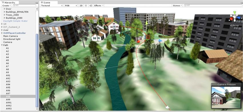
Fig. 2: Interface of the game engine Unity with the VR of the watercourse corridor along
the river Reppisch, Dietikon (CH). The red line represents the path that the camera
is automatically following when the game is started.
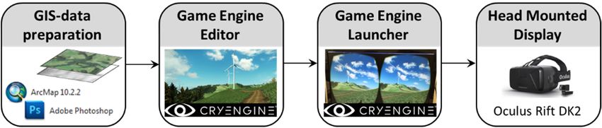
Virtual Reality (VR) 2: “Wind park in a hilly landscape”
The second VR simulates a possible wind park in a hilly area, a landscape type a lot of people
prefer for recreation in Switzerland. The simulation should support citizens to assess the im-
pact of the wind park on their enjoyment of the landscape. In this case, the VR was generated
with Crytek’s CryEngine 3.8 (www.crytek.com/cryengine), a game engine that directly sup-
ports the presentation with the Oculus Rift DK2 (Figure 3).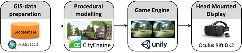
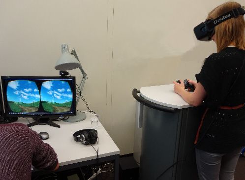
104                                             Journal of Digital Landscape Architecture · 1-2016

Fig. 3: Workflow for setup of VR 2 implementing Crytek’s CryEngine.

Implementing the workflow of MANYOKY et al. (2014) we set up the VR in the game engine
editor, the CryEngine Sandbox, based on a digital terrain model and an orthophoto of a hilly
area in Switzerland with a perimeter size of 4 × 4 km (4096 × 4096 pixels). We placed and
animated five wind turbine models (Vestas V 90) as well as the vegetation according to a
wind speed of 2.5 m/s at 10 m above ground. Further, we integrated recordings of sounds
generated by rotating turbine blades into the VR, which are replayed when setting the pro-
gram to game mode. The sound files were attached to so-called “Audio Trigger Spots” that
were placed at hub height of the wind turbines. The propagation of sound could only be
adjusted linearly. Hence, only a rough approximation of the logarithmic wind turbine sound
propagation could be implemented by using two linear curves.
For presentation the Oculus was connected to the PC and the final VR was opened in the
CryEngine Launcher, which starts it in game mode with the split screen (Figure 3). When
wearing the Oculus the viewer can look into any direction of the VR at any time. In order to
provide the viewer with a first overview of the wind park a video path was created. The
viewer enters the VR on the ground in a distance to the wind park. Then, by keyboard input
the video sequence is started, taking the viewer up and over the wind park, finally landing
on a path with a wind turbine in the field of view of the moving direction. In a distance of
800 m from a wind turbine the sound is audible, which was played back with two loudspeak-
ers. On the ground, the viewer sees the shadow of the character representing the viewer in
the VR. With a game pad, a wireless Xbox 360 controller, the viewer could then navigate
through the VR, walking for- and backwards as well as changing the direction.

4     Qualitative Research Design
Guided interviews and observations were conducted focusing on (1) the usability of the im-
mersive VR, (2) its quality to imagine the landscape, as well as (3) its potential advantages
and limitations as planning media. Responses from the participants were recorded and ana-
lysed according to variables and indicators defined for those three major aspects.
The virtual watercourse corridor (VR 1) was tested with 13 participants, which were repre-
sentatives of spatial and urban planning, landscape architecture, and engineering offices, of
different sections of the public administration (office for spatial development, urban planning
office, office of waste, water, energy and air), as well as students of the discipline spatial and
infrastructure planning. Most of the participants were already familiar with the topic of des-
ignating watercourse corridors. The participants view the VR with the Oculus while sitting
on a chair (Figure 4, left). Afterwards they were asked how they experienced it, whether they
U. Wissen Hayek et al.: Exploring Issues of Immersive Virtual Landscapes 105
think the feeling of presence provides an advantage for assessing the impact of the water-
course corridor on the visual urban quality, and how useful they consider the VR for planning
practice.
In total 33 participants perceived the virtual wind park (VR 2) which represent students and
researchers from heterogeneous disciplines (e. g., spatial and infrastructure planning, geog-
raphy, biology, and psychology), as well as citizens. The gender distribution of the partici-
pants was balanced and they represent age starting from 20-50 years, whereby the majority
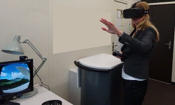
of them were of the age class 20-30 years. The participants stood at a desk wearing the Oculus
and – after experiencing the flight (see section 3.2, VR 2) – navigating individually through
the virtual wind park using the wireless Xbox 360 controller (Fig. 4, right). After approx. 5
minutes of observing the behaviour of the participant, questions regarding the navigation, the
orientation, the comfort, the presence, and the level of realism were asked while the partici-
pant still perceived the VR. Then, after the presentation the participant was asked questions
for deepening reflection on the VR.
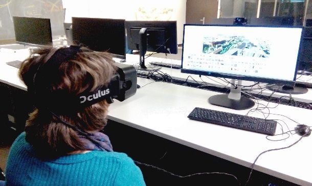
Fig. 4: Situations of the virtual reality presentations with the Oculus Rift DK2. Left: Par-
ticipant watching the virtual watercourse corridor presented along the video path.
Right: Participant navigating individually through the virtual wind park.
5 Results
With regard to the usability of the immersive VR, most of the participants had a positive
experience and felt comfortable during presentation with the Oculus. A few participants per-
ceiving VR 1 mentioned that it was overstraining and stressful. Only one person suffered
from so-called motion sickness during exploration of VR 2. Nearly all perceived a latency of
the view and some saw image flickering, which was said to be annoying. Concerning the
individual navigation in VR 2, a lot of participants navigated intuitively using the Xbox 360
controller, but some had major problems with it. Whereas they could change the viewing
direction by turning the head and with the controller, the walking direction could only be
influenced with the controller. So some walked in a direction they were not looking at. As
they perceived this as awkward they stopped looking around and hold the view straight in
walking direction. The other participants enjoyed to look around actively while exploring the
virtual landscape. Interestingly the participants all walked first into the direction they were
looking at when “landing” in the VR.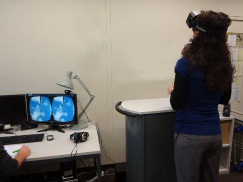
106                                             Journal of Digital Landscape Architecture · 1-2016

Focusing on the quality of the immersive VR to imagine the landscape, two-third of the
participants stated that they felt present in VR 2. The participants named the free choice of
view and the individual navigation as crucial aspects supporting their consciousness of being
present. They mentioned that they could experience the topography and had a better sense of
space. They felt enabled to easily estimate the proportion of the building size and of the open
space in VR 1 or the height of the wind turbines in VR 2. Some said that they did not notice
the real world anymore. Others physically leaned back when being in danger of falling down
in the VR, were careful when walking down a slope, tried to wave the shadow of the character
in the VR, or pointed with their hand while commenting on an area in the VR (Figure 5).
Participants regarded also the implementation of sound valuable to enhance their feeling of
being present. However, some noticed that the environmental sound was missing and that
the wind turbine sound propagation seemed to be incorrect. The level of immersion was re-
duced by the image latency, the low graphic resolution of the Oculus, and missing sensory
aspects such as wind or the possibility to touch the virtual objects. Further, participants per-
ceiving VR 1 criticized the low level of detail on the ground and that the VR appeared sterile
and lifeless. With regard to VR 2 most of the participants said that it looks generally realistic,
still the artificial vegetation was criticized.

Fig. 5: Left: Participant looking up to the top of the virtual wind turbine to estimate its
        height. Right: Participant commenting on landscape aspects in the virtual environ-
        ment and pointing on certain areas in the real world.

Asked about the potential use as planning media participants perceiving VR 1 mentioned
that immersive VR could be useful for communicating the idea of a spatial development
project to the general public. Only one participant assessed the immersive VR as not more
than amusing play. With regard to VR 1 participants said that in the pedestrian’s perspective
the buildings appeared less dramatic than from a bird’s-eye view. VR 2 motivated partici-
pants to comment on how they experience the wind turbines. One-third regarded them over-
sized, others said they were beautiful and dynamic, or that they characterize the landscape.
Furthermore, they remembered a lot of details they viewed and experienced in the virtual
wind park. Overall, the majority of the participants had fun exploring the VR. However,
some of the experienced Xbox-Gamers seemed to be bored due to missing interactive ele-
ments in VR 2. Also with regard to VR 1 it was wished that the user could interact and make
changes in the VR.
U. Wissen Hayek et al.: Exploring Issues of Immersive Virtual Landscapes 107 6 Discussion and Conclusions We demonstrated how to generate immersive VR and showed that the Oculus Rift DK2 is already quite useful for this task. In this section we focus on crucial aspects with regard to the preparation and the implementation of immersive VR derived from the study results, and we conclude on further research directions. The ease of navigation is an important factor for evoking in the viewer the feeling of being present in the VR. Free navigation was very supportive, whereas the video path provided an overview of the VR and points for orientation. These were helpful for the viewer when nav- igating individually. A combination of restricted and free navigation, thus, seems to be use- ful. Furthermore, we recognized that with the defined point and viewing direction for “land- ing” in the VR the viewer can be focused in the exploration. This might be useful for targeted evaluation of certain landscape aspects. Based on the participants’ responses we see that the visual level of realism can play an im- portant role for supporting the feeling of presence in the VR. Participants perceiving VR 1 were distracted by the low level of realism and atmosphere. Also VR 2 was still criticized for being not highly realistic. Nevertheless, the immersive VR proved useful to activate peo- ple assessing the landscape quality in the VR. Studies are needed to understand more in- depth the participant’s experience of the aesthetic appearance and atmosphere in order to identify suitable and valid immersive VR for landscape quality assessment. Further, a com- parison with non-immersive visualizations and including citizens into the evaluation are re- quired to study the added value of immersive VR for participatory planning. References AUSTINAT, R., GIESELMANN, H. & JANSSEN, J.-K. (2015), Ausprobiert: Zukunftige Virtual- Reality-Brillen im Praxis-Check. c’t Wissen Virtual Reality, 42-48. GUTIÉRREZ, M. A., VEXO, F. & THALMANN, D. (2008), Stepping into virtual reality. Springer, London. KULIGA, S. F., THRASH, T., DALTON, R. C. & HÖLSCHER, C. (2015), Virtual reality as an em- pirical research tool ‒ Exploring user experience in a real building and a corresponding virtual model. Computers, Environment and Urban Systems. doi:10.1016/j.compenvurbsys.2015.09.006. LOVETT, A., APPLETON, K., WARREN-KRETZSCHMAR, B. & VON HAAREN, C. (2015), Using 3D visualization methods in landscape planning: An evaluation of options and practical issues. Landscape and Urban Planning, 142, 85-94. MANYOKY, M., WISSEN HAYEK, U., HEUTSCHI, K., PIEREN, R. & GRÊT-REGAMEY, A. (2014), Developing a GIS-based visual-acoustic 3D simulation for wind farm assessment. ISPRS Int. J. Geo-Inf., 3 (1), 29-48. doi:10.3390/ijgi3010029. NEUENSCHWANDER, N., WISSEN HAYEK, U. & GRÊT-REGAMEY, A. (2014), Integrating an ur- ban green space typology into procedural 3D visualization for collaborative planning. Computers, Environment and Urban Systems, 48, 99-110. PALMER, J. (2015), Effect size as a basis for evaluating the acceptability of scenic impacts: Ten wind energy projects from Maine, USA. Landscape and Urban Planning, 140, 56- 66.
108                                           Journal of Digital Landscape Architecture · 1-2016

PARISH, Y. I. H. & MÜLLER, P. (2001), Procedural Modeling of Cities. SIGGRAPH '01
   Proceedings of the 28th annual conference on Computer graphics and interactive tech-
   niques, 301-308. doi:10.1145/383259.383292.
SLATER, M. & WILBUR, S. (1997), A Framework for Immersive Virtual Environments
   (FIVE): Speculations on the Role of Presence in Virtual Environments. Presence: Te-
   leoperators and Virtual Environments, 6 (6), 603-616.
STAUSKIS, G. (2014), Development of methods and practices of virtual reality as a tool for
   participatory urban planning: a case study of Vilnius City as an example for improving
   environmental, social and energy sustainability. Energy, Sustainability and Society, 4 (7).
   doi:10.1186/2192-0567-4-7.
SUTHERLAND, I. E. (1968), A head-mounted three dimensional display. AFIPS '68 (Fall, part
   I) Proceedings of the December 9-11, 1968, fall joint computer conference, part I, 757-
   764. doi:10.1145/1476589.1476686.
You can also read