Implementation of Multipath Routing System for Android Operating
←
→
Page content transcription
If your browser does not render page correctly, please read the page content below
Implementation of Multipath Routing System for Android Operating
                                   System

                                            Manjunath A Ea *, Anupama H Sb, Cauvery N Kc
                          a , b, c
                                     ,R.V.College of Engineering, Department of Computer Science and Engineering, Bangalore, India.
                                                      Email: b anupamahs@rvce.edu.in, c cauverynk@rvce.edu.in

Abstract

    The native Google maps application on any handheld devices can be used for two sources only, the start and the end location. The user
is unable to input multiple locations on the map. The complete driving directions are available on a different page, which makes navigation
difficult, as the user has to toggle between pages. This application addresses these issues. The start location is computed using Global
Positioning System (GPS) and the results are displayed with the help of Google Maps. The application uses Google Maps as an atomic and
reusable feature. The Map View function is used to display, manipulate, and annotate Google Map within activities to build the application
using the Google Maps interface. The Google Directions application program interface is used to calculate directions between locations
using a hypertext transfer protocol request. Directions are specified as origins, destinations and waypoints either as text or as
latitude/longitude coordinates. The application displays maps using location data using Google application program interface, providing
powerful mapping capabilities to the user[1]. The optimized shortest path is computed using travelling salesman algorithm.

Keywords: GPS, Google Maps, HTTP, Handheld Devices, Shortest path, Android

1.    Introduction                                                                       The authors relate how GPS, geocoding and reverse
                                                                                     geocoding can be best made use of. It focuses on the need
   Until recently, mobile phones were largely closed                                 to import data on mobile devices ensuring that a user when
environments built on highly fragmented, proprietary                                 visiting places need not carry the travel guides with him.
operating systems that required proprietary development                              All the information must be available in his mobile device
tools. The phones themselves often prioritized native                                and also in user customized format. Points related to similar
applications over those written by third parties. This has                           application are described in [2] A public safety application
introduced an artificial barrier for developers hoping to                            of GPS-enabled smart phones and the android operating
build on increasingly powerful mobile hardware [15].                                 system and [3] Indoor/outdoor management system
Android sits alongside a new wave of mobile operating                                compliant with Google Maps and Android OS. The authors
systems designed for increasingly powerful mobile                                    describe problems faced by them while developing location
hardware. Windows Mobile, the Apple iPhone, and the                                  based applications and their customization. Android’s
Palm Pre now provide a richer, simplified development                                location-based services manage technologies like GPS and
environment for mobile applications. However, unlike                                 Google’s GSM cell-based location technology to determine
Android, they’re built on proprietary operating systems that                         the device’s current position. These services enforce an
in some cases prioritize native applications over those                              abstraction from specific location-detecting technology and
created by third parties, restrict communication among                               let specify minimum requirements (e.g., accuracy or cost)
applications and native phone data, and restrict or control                          rather than choosing a particular technology. Travelling
the distribution of third-party apps to their platforms. The                         today is not very easy. One has to travel to multiple
basic of the location based services was understood by                               locations in a day. Many people during the course of the
going through [3, 15].                                                               day stop at various locations which may be very far away.

     * Corresponding author. manjunathae@rvce.edu.in

                                                                               173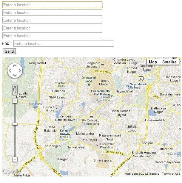
Also the traffic on the road results in commuters spending 2.1 System Design
many hours on the road. This time is mostly unproductive.
Hence one should save as much travelling time as possible. Structure design shows the control flow among the
The designed application plots the various locations on a modules in the system. The structure design explains the
map and returns the Optimized route between the start and identified modules, the interaction between the modules
end points. [4]The user can thus plan their day in advance. and the identified Sub-Modules. It also explains the input
This will help them reduce time on road. Mobile phones are for each modules and the output generated by those
portable and the application can be used while travelling. modules. Figure 2 shows the structure design of the
Making use of internet service the user can give stop-over’s application [5]. It shows the sequence of function calls in
to decide on the best path for driving. The application the system. The calling sequence is from top to down and
provides driving directions which make it easier to left to right.
navigate. The application has the following major modules which
guide the working of the whole system. The modules were
classified according to their functionality in the overall
2. Proposed System application. The following modules were identified to be
part of the algorithm design.
We now describe the architecture used to identify the
multiple paths routing system in Android Operating system. GPS and Google Key Setup Module
The system architecture in Figure 1 shows the blocks Google key setup is the module which runs only once
required for the application. when the application is started and sets a key. The GPS is
Presentation tier is also known as presentation layer. responsible for getting start location. This module is
This layer handles the user interface of the responsible for calculating the current location using GPS,
application. This is the top most level of the identifying and setting up a Google key for legal extraction
application. It communicates with other tiers by of data from the Google server, it sets the key once in a
interacting with the user and displaying results to java script variable and is used numerously later whenever
the users. required [8]. The current location is calculated and passed
The application tier is pulled out from the as a starting address for further computations.
presentation tier as its own layer; it controls an Step1: The GPS sensor is started by including
application’s functionality by performing detailed scripttype="text/javascript"
processing. Step 2: Using W3C geolocation API display lat-long
This tier consists of database servers. Here values
information is stored and retrieved. This tier keeps
data neutral and independent from application Ajax Filter Module
servers or business logic. Giving data its own tier The Ajax filter module comes up for validating the
also improves scalability and performance [16]. addresses entered by the user. The sole purpose of this
module is validating the address (waypoints and the end
point) entered by the user and showing the user the
locations entered on the map [9].
Step 1: First of all map variable
Step 2: The input is taken character by character and
auto complete
Step 3: Marker is initialized and bound to map
Step 4: A listener is added to the auto complete variable
so as to dynamically
Step 5: Marker position is set to the required location
Geocoder and Path Optimizer
The module comes up when the address list has been
selected. It shows the final optimal path. The purpose of the
module is to find the start address by reverse geocoding [7].
Then the optimized path and driving directions are
calculated and displayed accordingly.
Step 1: Initialize a point variable with current lat-long
values:
Step 2: Check if end point is not specified and if so by
default end value is
Step 3: We execute the query for computing optimized
route.
Figure 1. System Architecture for Android Application based on routing Step 4: The result is displayed on the device
174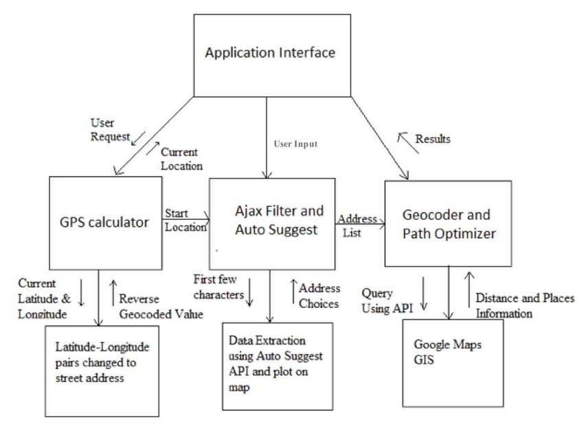
Figure 2. Structure Chart for Android Application for routing

                                                                             Auto-Suggest list is immediately plotted on the map. It is
                                                                             tested independently and the test is shown in table 2
3. Application testing and results
                                                                                      Table 2: Test Case for Map Display and Plotting Marker
   Unit testing is the process of testing individual
components in the system. A unit is the smallest entity of
an application. So unit testing is a procedure used to
validate whether individual units of source code are
working properly[10]..

3.1 Unit testing of GPS for current location

    This test checks whether the user is getting the current
Latitude and longitude coordinates through GPS. The test
does not require any input as the points are automatically
calculated. It is tested independently and the test is shown
in table 1.

          Table 1: Test Case for Getting Current Location

                                                                             3.2 System Testing

                                                                                System testing is done to understand the application
                                                                             performance and also to evaluate if all the components are
                                                                             compatible in varied environments. Performance testing is
                                                                             done to evaluate the application’s performance under a
                                                                             particular workload as shown in figure 3. It also validates
                                                                             and verifies other quality attributes of the application, such
                                                                             as scalability, reliability and resource usage. Compatibility
                                                                             testing is used to evaluate the application’s compatibility
                                                                             with the computing environment [6].

                                                                       175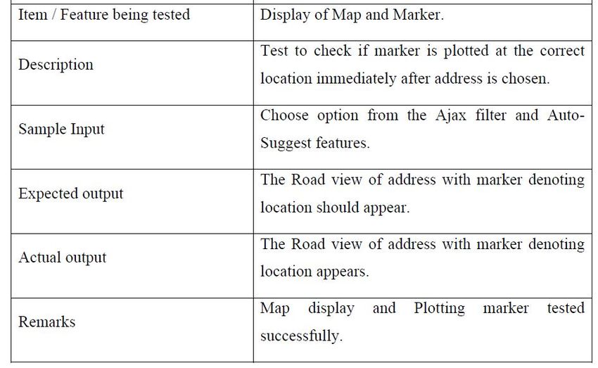
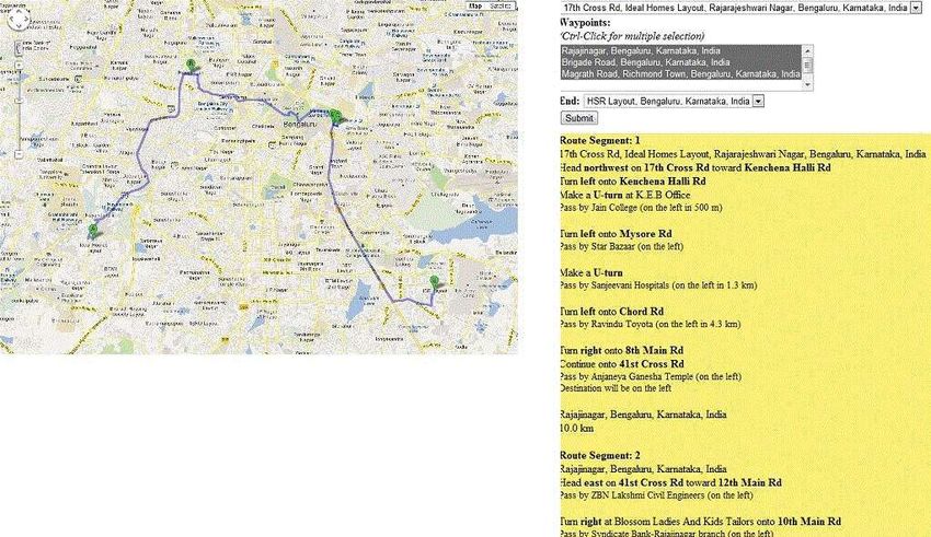
Fig 3: Optimized Path Finder from waypoints and end location input page

              Fig 4: Optimized Path and driving directions

                                 176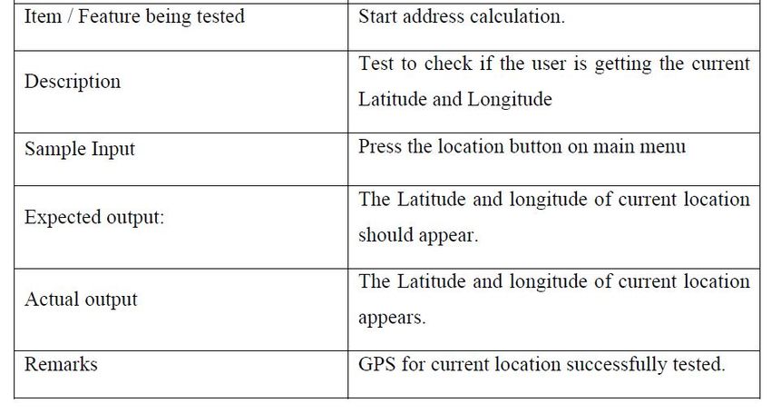
The application is tested using different Internet Specific house addresses are not available hence only
connection speed, on the Eclipse Emulator for Android on street address can only be searched.
the desktop. It was also tested on the Android Smartphone. The Application can only be used in the countries where
It was found that the places where Wi-Fi connection is Google map is applicable.
available provided far more accurate results [13,14 ]. The Android Smartphone screens are small and
processor speed is slow resulting in the reduced Map
3.3 Functional Testing of the GUI view which makes it hard to navigate the map.
There are number of ways that this application could be
The objective of functional testing is to make sure that extended. With the native Google maps application there is
the GUI is working correctly and the user is able to no feature to add multiple waypoints in the search query.
successfully navigate the application. In functional testing Also driving directions for two sources are displayed on a
the interface is tested, particularly the external interfaces of different page which makes it difficult for one to navigate.
the system. The emphasis is on verifying exchange of data, The users find it difficult to decide to go over/under bridge
transmission and control, and processing times. The using only the GPS. .
interface provided must be understandable. Also since the Traffic Analysis can be added by Timing the distance
map has zoom facility it is essential to consider the screen- between any two points and storing in the database. This
size of the device while displaying output [11]. The map can provide user real time updates.
canvas was appropriately selected. The result page shows If a database containing information in a particular area
both the map and the driving directions and it is difficult to is built then the Application could use for prompting
navigate as shown in figure 4. Hence appropriate spacing is local business. For e.g., if the entire medical clinic in
needed for better interfacing. This was constantly checked “Jayanagar” are mapped, it could provide user’s
and the map canvas accordingly modified. The application appointment with the doctor.
is tested on the Eclipse Emulator for Android on the The modules are built using JavaScript, Java and
desktop computers. It provides real android like uploaded on web server making it easy to launch on
capabilities. The benefit of using the emulator is that the other platforms like iOS with a few changes.
application need not be tested individually on different If a text to speech feature is added to the application,
devices. The emulator itself provides the environment navigation while driving becomes easy.
required for testing [12].
References
4. Conclusion
[1] Amit Kushwaha, Vineet Kushwaha, “Location Based Services using
The application provides the user additional features over Android Mobile Operating System”, In International Journal of
the existing Google Maps Application on Android. The Advances in Engineering & Technology, Vol. 1,Issue 1,pp.14-20, Mar
2011.
user plots various locations on a map and the application [2] Whipple J, “A public safety application of GPS-enabled smartphones
returns the optimized route between the start and end and the android operating system” In Systems, Man and Cybernetics,
points. The user can thus plan their day in advance. This 2009. SMC 2009. IEEE International Conference, San Antonio, Texas,
will help them reduce time on road. Since the mobile page 2059-2061, 11-14 Oct. 2009.
[3] Ludimar Gu, Luis Bras, Marco Oliveira, NunoBorges Carvalho,
phones are portable the application can be used while
“Indoor/outdoor management system compliant with Google Maps
travelling. Making use of internet service the user can give and Android OS”, In IEEE EUROCON International Conference on
stop-over to decide on the best path for driving. The Computer as a Tool, Pages 1-4, 2011.
application provides driving directions which make it easier [4] Bircher, W. L, John, L. K ,“Complete system power estimation:
approach based on performance events of android” . In Proceedings of
to navigate. This provides the users an application for the IEEE International Symposium on Performance Analysis of
finding the shortest navigable path between multiple points. Systems and Software, San Jose, IEEE Computer Society, pp. 158–
Say, a medical representative has to go to five places 168, Apr. 25–27 2007.
during the day. He can make appointments on the basis of [5] Peji , B ,Peji , A ; ovi , , “Uses of W3C's Geolocation API” In
Computational Intelligence and Informatics (CINTI), 2010 11th
distance travelled and time taken to get there. The shortest International Symposium, Budapest , Page(s): 319- 322, 18-20 Nov.
path is found and shown on a map for the user’s 2010.
convenience. The driving directions from start till end point [6] Reto Meier, Professional Android™ 2 Application Development,
are displayed on the same page. Indianapolis, IN 46256, by Wiley Publishing, Inc., Indianapolis,
Indiana ISBN: 978-0-470-56552-0, 2010.
[7] Mark L Murphy “The Busy Coder's Guide to Android Development”,
CommonsWare, Version 1.0 ISBN: 978-0-9816780-0-9, July 2008.
5. Limitations and Future Enhancement [8] Marko Gargen “Learning Android”, Marko Gargenta Published by
O’Reilly Media, Inc., 1005 Gravenstein Highway North, Sebastopol,
CA 95472. ISBN: 978-1- 449-39050-1, 2011.
Though it is well-modulated application, it has been [9] Jason Morris “Android User Interface Development”, Published by
limited to certain restrictions Packt Publishing Ltd. 32 Lincoln Road Olton, Birmingham, B27 6PA,
A Fast Internet connection is needed; otherwise the map UK. ISBN 978-1- 849514-48-4, February 2011.
[10] De Angelis, G ; Baruffa, G ; Cacopardi, S “Cellular Hybrid
tiles fail to load. Positioning System for mobile users in urban environments”,
Published by ITSS publications, ISSN 1524- 9050, 2013.
177[11] Zhang, B.; Hao, J ; Mauftah, H , “Bi-directional multi-constraint [14] Retscher, G ; Hecht, T “Investigation of location capabilities of four
routing algorithm” , Published by Conference Publications, ISBN different smart phones for LBS navigation applications” , Published by
0018-9340, 2012. Conference Publications, ISBN 978-1-4673-1955-3, 2012
[12] Wallace Jackson “Android Apps For Beginners”, Published by [15] Reto Meier (2010) Professional Android 2 Application
Apress Publication, ISBN-13 (electronic): 978-1-4302-3447-0, 2011. Development. Available: http://www.barnesandnoble.com/w/professio
[13] Abubakar, A Waili, T ; Mantoro, T “Unveiling the support of 3d nal-android-2-application-Development-retomeier/1100295401? =
representation in mobile devices for pedestrian navigation aid”, 978047056.[Accessed 5th June 2013].
Published by Conference Publications, ISBN 978-1-4673-1518-0, [16] Ali Tarhini (2011) Concept of Three Tier Architecture.Available:
2012. http://alitarhini.wordpress.com/2011/01/22/concepts-of-three-tier-
architecture/ . [Accessed 5th June 2013].
178You can also read