Inadequate Regulation of the Geological Aspects of Shale Exploitation in the UK - MDPI
←
→
Page content transcription
If your browser does not render page correctly, please read the page content below
International Journal of
           Environmental Research
           and Public Health

Review
Inadequate Regulation of the Geological Aspects of
Shale Exploitation in the UK
David K. Smythe
 College of Science and Engineering, University of Glasgow, Glasgow G12 8QQ, UK;
 david.smythe@glasgow.ac.uk

 Received: 19 July 2020; Accepted: 14 September 2020; Published: 23 September 2020

 Abstract: Unconventional oil and gas exploitation, which has developed in the UK since 2009,
 is regulated by four main agencies: The Oil and Gas Authority, the Environment Agency, the Health
 and Safety Executive and local Mineral Planning Authorities (usually county councils). The British
 Geological Survey only has an advisory role, as have ad hoc expert committees. I firstly define terms,
 and summarise the remits of the regulators and background history. Fourteen case histories are then
 discussed, comprising most of the unconventional exploitation to date; these cases demonstrate the
 failure of regulation of the geological aspects of fracking operations in the UK. The regulators let
 inadequacies in geological understanding, and even mendacious geological interpretations by the
 hydrocarbon operators slip through the net. There are potentially severe implications for environmental
 safety—if and when permits are granted. Geological pathways, if not properly understood and
 mitigated, may lead to long-term pollution of groundwater and surface water; methane and H2 S
 emissions. Induced earthquakes have not been well regulated. The case histories demonstrate a
 laissez-faire and frequently incompetent regulatory regime, devised for the pre-unconventional era,
 and which has no geological oversight or insight.

 Keywords: fracking; unconventional; hydrocarbon; exploration; drilling; well; regulation

1. Introduction
      During the last decade, the era of fracking, the UK regulatory system for onshore hydrocarbons [1]
has been vaunted by the government since the inception of fracking as “robust” [2] and that it: “should
be the gold standard that others should aspire to” [3].
      This is not and has never been the case [4,5]. The regulation was designed for the pre-fracking era;
“old regulations are being used to govern a new technology” [6]. In practice, as the case histories below
will show, the regulation has been wanting. In particular, the responsibility for scrutinising the geological
aspects of unconventional exploration tends to fall between the stools of the several regulators.
      The most important regulator from the geological point of view would appear to be the Oil and
Gas Authority (OGA). Its role is “to regulate, influence and promote the UK oil and gas industry in
order to maximise the economic recovery of the UK’s oil and gas resources”. However, as we shall
see, the Environment Agency (and its equivalent in Scotland, the Scottish Environmental Protection
Agency) turns out to have the main responsibility concerning geology.
      Scrutiny of the geology, as presented by operators during the planning process, is crucial because
of the potential pollution which may occur, and which may be an order of magnitude larger than that
from conventional oil and gas activities. This includes groundwater and surface water pollution by
brine, heavy metals, radioactive elements (both heavy and light) and by extremely toxic chemicals used
in fracking like polyacrylamide; methane and H2 S emissions; disposal of produced water (a by-product
of the fracking process); and earthquakes.

Int. J. Environ. Res. Public Health 2020, 17, 6946; doi:10.3390/ijerph17196946    www.mdpi.com/journal/ijerph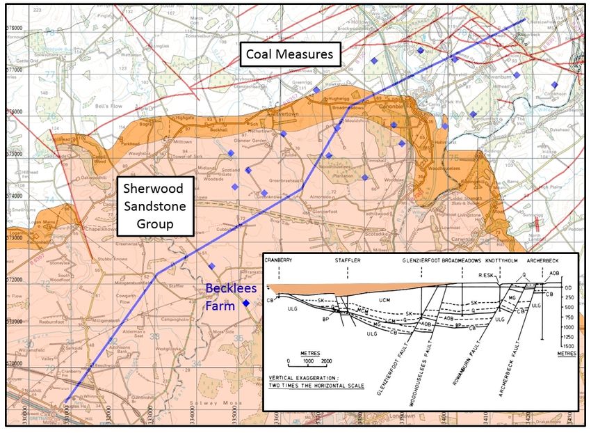
Int. J. Environ. Res. Public Health 2020, 17, 6946                                                      2 of 60

     The two major aquifers in the UK are the Chalk and the Sherwood Sandstone Group. Each of
these usually lies above, or adjacent to, formations that are being exploited unconventionally—the
Kimmeridge Clay Formation and the Bowland Shale, respectively [7]. Faulting, which is complex
in the UK, compared to, say the shale basins of the USA, provides the pathway between deep and
shallow groundwater systems. Therefore, the intrinsic risk of contamination of the aquifers is high.
     Firstly, I summarise some necessary definitions of terms used in unconventional exploitation,
for the benefit of non-technical readers. Then I review and analyse the geological aspects of the
regulators, highlighting their behaviour and performance in the face of the new problems created by
unconventional exploration. Such an emphasis on geology has not hitherto been presented. A series of
fourteen case histories follows. The technical weaknesses or failures of the industry are pointed out
where necessary to highlight how and why regulation has either failed, or is inadequate, in each case.
The review is not a critique of the industry per se, but of its regulation.
     These geological case histories include Scottish examples of coal bed methane (CBM) exploration
proposals, and some English examples include cases in which the exploration is presented by the
industry as conventional, but in which an agenda of potential future unconventional activity is implicit.
They are presented in approximately chronological order, grouped by region, as follows, with the
number of separate case histories shown as follows:

•     The Weald: 2008 to 2014                        2
•     Scotland: coal bed methane                     2
•     Lancashire: 2009–2014                          1
•     The Weald: 2014 to date                        4
•     Lancashire: 2014 to date                       2
•     East Midlands                                  1
•     Cheshire                                       1
•     South-eastern England                          1

     The primarily chronological order is necessary to trace the evolution of regulation over the
last decade. Extra background information is provided in a single Supplementary Information (SI)
document, divided under different headings.

2. Onshore Licensing and Regulation—General

2.1. Licensing
     The main licensing regime for onshore oil and gas exploration and production in the UK dates
back to the Petroleum (Production) Act 1934 [8], even though some licences had been issued under a
1918 Act [9]. The current regime is controlled by the Petroleum Act 1998 [10]. This date precedes the
advent of ‘unconventional’ hydrocarbon exploration (terms are defined below), which came of age
in the USA around 2005. The 1998 Act has since been modified to incorporate the new technique of
hydraulic fracturing (‘fracking’), but definitions used by the UK regulators are at times vague, do not
correspond to scientific definitions [11], and can be internally inconsistent [12].
     Blocks of land for licensing are offered by the government (currently the Department for Business,
Energy and Industrial Strategy, DBEIS) in periodic licence rounds. Applicants may be awarded one or
more blocks at the discretion of the Secretary of State. If there is competition for the same block, the ‘best’
applicant will be awarded a Petroleum and Exploration Development Licence (PEDL). Inadequate
applications may result in a particular block not being licensed. The system is thus discretionary;
the fees paid for acquiring a licence block are minimal.
     The Department of Energy controlled the licensing from 1973 to 1992, at which point its core
responsibilities, including licensing, were transferred back to the Department of Trade and Industry
(DTI). Responsibility then passed to the new Department of Energy and Climate Change (DECC) from
2008 to 2016, following which DECC was absorbed into DBEIS. The Oil and Gas Authority (OGA) had
Int. J. Environ. Res. Public Health 2020, 17, 6946                                               3 of 60

previously been established in April 2015 as an executive agency of DBEIS, then on 1 October 2016
it was incorporated as a Government Company, with the Secretary of State as the sole shareholder.
Currently the OGA has the responsibility for licensing.
     Recently, legal doubt has arisen about whether a licence is administered by predetermined
regulation, or is essentially a contract between two parties [13] and therefore open to variation by
mutual agreement. Such doubt has arisen due to the behaviour of the OGA regarding the grant of
extensions to the duration of some onshore licences.

2.2. Regulation
     Regulation of the onshore hydrocarbon exploration and production industry is shared between
four separate entities [14]:

•     OGA; it conducts licensing rounds and awards blocks (see above), also monitors
      subsequent activity.
•     Environment Agency (EA; the equivalent body in Scotland is the Scottish Environmental Protection
      Agency, SEPA); it issues a permit when it is satisfied that the proposed activity will not cause
      environmental harm.
•     Minerals Planning Authority (MPA); the MPA is the County Council (in two-tier parts of the
      country), or else the Unitary Authority, or else the National Park Authority; it grants planning
      consent [15].
•     Health and Safety Executive (HSE); it issues a drilling permit once it is satisfied that the well
      design is safe; subsequently it visits and monitors the drilling and production activity.

      How these separate entities interact is discussed in the next section. In many ways the MPA is
central to the whole process, as shown by an organogram from 2013 (SI: Figure S1).
      From time to time expert committees have been set up and public consultations (in addition to
the routine local authority planning application consultations) have been held. These include the
joint Royal Society and Royal Academy of Engineering working group, the Scottish expert committee,
and the ad hoc Newdigate earthquake working group. Public consultations are routine practice for
planning applications to MPAs; some of them attracted record numbers of submissions because of the
controversial nature of fracking. A national Scottish consultation on unconventionals was held in 2015.
      In two of the case histories discussed below the development proposals were sent to a public
inquiry. In each case the inquiry report was called in for determination by the relevant minister, but,
at the time of writing, no determination has been handed down in either case.

3. Scrutiny of the Geological Aspects of the Licensing System

3.1. Definitions
     Prior to 2010 all exploration in the UK was ostensibly conventional, but the dividing line between
conventional and unconventional became blurred by Cuadrilla’s planning application of January 2010
to drill an exploratory well at Balcombe, Sussex. This case history is discussed below.
     A conventional oil or gas resource is hosted in a well-defined finite volume of rock called the
reservoir; the resource can be extracted without needing to alter the bulk rock properties. The oil or
gas will have been formed elsewhere in a source rock, and will have migrated over geological time to
become trapped in the reservoir. Figure 1 shows a cartoon cross-section of oil and gas collecting in
geological structures, inhibited from percolating upwards by a seal. The oil or gas, being less dense
than the brine it displaces, tends to flow upwards under gravity.
Int. J. Environ. Res. Public Health 2020, 17, 6946                                                                           4 of 60
Int. J. Environ. Res. Public Health 2020, 17, x                                                                             4 of 59

      Figure 1. (a) Conventional and unconventional oil and gas location in geological structures. This cartoon,
      Figure 1. (a) Conventional and unconventional oil and gas location in geological structures. This
      from the US Energy Information Administration, shows simple US-style geology with a thin, unfaulted
      cartoon, from the US Energy Information Administration, shows simple US-style geology with a thin,
      shale layer. (b) Cross-section of water flow up a fault zone. The core, central part of a fault (black) may
      unfaulted shale layer. (b) Cross-section of water flow up a fault zone. The core, central part of a fault
      either be transmissive or else be a barrier. The damage zone on either side, comprising fractured rock,
      (black) may either be transmissive or else be a barrier. The damage zone on either side, comprising
      will usually be transmissive. The resulting conceptual water flow from right to left is indicated by
      fractured
      red arrows.rock, will usually be transmissive. The resulting conceptual water flow from right to left is
      indicated by red arrows.
   The trapped oil or gas may be recovered to the surface by natural flow pressure up a borehole;
   The trapped
however, steam oroilwater
                      or gasmay
                             maybe
                                 be injected
                                     recoveredto to the surface
                                                  direct          by natural
                                                          or encourage   the flow
                                                                              flow.pressure up a borehole;
                                                                                     The wellbore   and its
however, steam   or  water  may  be  injected  to  direct or  encourage   the  flow. The wellbore
immediate vicinity (
Int. J. Environ. Res. Public Health 2020, 17, 6946                                                     5 of 60

      The generally accepted boundary between ‘tight’ reservoir rocks requiring massive
(unconventional) treatment and conventional reservoir rocks is a permeability of 0.1 millidarcies
(SI: Figure S2).

3.2. Pre-Fracking Practice in the UK
     Up to 2010, all drilling for oil and gas in the onshore UK was conventional. Between about 2007
and 2015 applications for coal bed methane exploration, which is a form of unconventional activity,
were made, but none of these resulted in licensing and drilling.
     A hydrocarbon company wishing to acquire a PEDL, and thereby become an operator (the single
responsible legal entity, perhaps in financial partnership with other companies) would first study
the geology in the area of interest, and identify specific leads. These are defined volumes of the
subsurface which may contain oil or gas. If a risk assessment is carried out, a lead may be upgraded
to a prospect; that is, a specific target ready to be drilled. This prior study is not carried out in vacuo;
one of the merits of the UK licensing system is the preservation, archiving and eventual release of all
commercially-obtained exploration drilling and seismic reflection data. In the sedimentary basins
where hydrocarbons occur this vast database greatly outweighs the subsurface and surface mapping
studies of the British Geological Survey (BGS), the oldest national geological survey in the world,
established in 1835.
     The confidential well logs and seismic data acquired commercially in previous exploration
campaigns are released after a confidentiality period of five years. The seismic data are available for
online inspection at the UK Onshore Geophysical Library [18] (UKOGL), which also provides the
locations of the wells and their tops (depths to the top of each relevant geological layer) if the well
has been released; the well logs themselves may be purchased from other OGA agents. The cost of
obtaining all the relevant data for a typical block (a 20 km × 20 km square, based on the National Grid),
may amount to a few thousand pounds. This is a tiny fraction of the cost of drilling an onshore well
(GBP ~1–2 M) or acquiring new seismic data (GBP ~10 K/linear kilometre).
     Licences are awarded on a discretionary work programme-based bid basis. In the UK sector there
have only ever been three sealed cash bid auctions [19], which were all for offshore blocks in 1971–2,
1982–3 and 1984–5. I have personal experience of how the PEDL licence application system works,
having sat on the government side on one occasion with Department of Energy officials interviewing
BP in 1984, and on the other side of the table at a similar DECC interview in 2009, when I represented a
client who was applying for onshore licences in the south of England. I am probably the only person
who has had such an experience of the interview process at work from both sides.
     At the application interview the applicant presents his or her ideas and work plans for the leads
and prospects identified, but in my experience the geological interpretation carries little weight, per se.
What counts most is the proposed work programme, which is assessed by a point-scoring system,
weighing up, for example:

•     How many firm wells will be drilled;
•     How many conditional wells will be drilled (depending on prior studies);
•     Reprocessing of existing seismic data;
•     How many linear or square kilometres of new 2D or 3D seismic data, respectively, will be acquired;
•     Any other data acquisition methods, e.g., reprocessing of existing data, or novel analysis tools,
      to be used.

      In short, the regulator (currently the OGA) takes little or no account of the geological interpretation
that is proposed. As we shall see from the case histories, this did not matter when the exploration was
conventional, but with unconventional resource exploration it has become crucial.
      Once a PEDL is awarded, the new operator must fulfil the conditions promised in the work
programme within the Initial Term of the licence agreement. This is normally of five years duration,
and the operator also thereby agrees that the data will become public, even if the PEDL is retained after
Int. J. Environ. Res. Public Health 2020, 17, 6946                                                  6 of 60

the period of confidentiality has expired. Background checks on the financial viability of the operator
are also made.
      Such an award system used to be robust. There was a boom in onshore exploration activity in
the 1970s and into the 1980s, up to early 1986, when the price of Brent crude (the main European
measure of oil trading) fell from USD 29 per barrel to USD 13 [20]. This price collapse put an end to
most UK onshore oil exploration. Up till then the bulk of the exploration had been carried out by
the oil majors—BP, Shell, Conoco, British Gas Corporation (BGC), etc.—with only a handful of minor
independent (stock market unlisted, or private equity) companies playing a part.
      The technical expertise and financial probity of these companies was not in question. In addition,
the environmental risks of drilling vertical wells are small. If a wildcat exploration well came in ‘dry’,
because the prognosis turned out to be incorrect, the only loss was to the investors. The well would be
plugged and abandoned, and there will be little or no lasting damage to the environment.
      During the 1980s ‘extended-reach’ horizontal drilling techniques were developed. In the onshore
UK domain, this new method was pioneered by BP, which had previously discovered the Wytch Farm
field in Dorset in 1974 in partnership with BGC. These wells enabled the field, which is the largest
onshore oilfield in western Europe, to produce oil from some 12 km out into Bournemouth Bay from a
single drilling pad onshore south of Poole Harbour [21]. It should be noted that the exemplary practice
by the operator at Poole Harbour applies to horizontal drilling through the sandstone reservoir, but
has little in common with the later development of horizontal fracked wells in shale. Fracking has
never been carried out at Wytch Farm, contrary to some opinions [22] which try to cite Wytch Farm
(SI: Figure S3) as an example of environmentally safe practice, applicable to fracking of shale wells.

3.3. The Advent of Fracking
      The shale gas boom in the USA started in about 2006, and reached a peak in 2011. It resulted
from the marriage of two technologies; the development of extended-reach drilling mentioned above,
together with the successful application of hydraulic fracturing (fracking) of shale to increase its
permeability. The latter technique came of age in about 2003. By 2008 the apparent success of the
unconventional shale gas industry in the USA was beginning to excite both exploration companies and
the government in the UK.
      An important difference between the geology of shale basins in the USA and those of Europe is that
the former are geologically very simple, with thin shale layers and largely no faulting (vertical and/or
horizontal offsets of the layers). This is shown in Figure 1a. However, in Europe the shale is found in
faulted basins where the shale is much thicker. Such faults may act as conduits or barriers to the flow of
groundwater [23], as illustrated in Figure 1b, and also act as potential conduits for contamination from
a fracked shale to near-surface groundwater and to the atmosphere. This danger, which was mentioned
in an early US oil industry review [24] referring to shallow fault-bounded accumulations in which the
fault “penetrates to or near the surface” was considered to be rare, but in Europe such faulting, linking
deep structures to the surface, is commonplace. Faulting was recognised as a potential environmental
hazard, if fracking were to be performed, in reports produced for governments in Germany [25] and in
France [26]. These reports (and others) helped to lead to moratoria on fracking in these two countries.
      The water industry is aware of faults as conduits, and, indeed, takes advantage of that fact.
For example, the United Utilities Cumbrian website in 2011 stated (apropos of the Sherwood Sandstone
Group at outcrop):

      “03 February 2011: We are using drilling rigs to explore for one of Cumbria’s most precious
      natural resources—water. Our specialist teams have plunged four boreholes up to 120 m
      deep in fields south of Egremont to pave the way for a potential new groundwater supply.
      Project manager Danny Brennan said: ‘The boreholes have been sited to target geological faults
      to give the best access to the yields’” (emphasis added).
Int. J. Environ. Res. Public Health 2020, 17, 6946                                                     7 of 60

     The report is currently still available on the website WaterBriefing [27]. The Sherwood Sandstone
Group (SSG) is one of the two most important aquifers in the UK, the other being the Chalk. Recently,
Medici et al. [28] used deep boreholes from Sellafield, West Cumbria, to demonstrate that extensional
faults at c. 800–900 m below sea level within the SSG are preferential flow pathways. More generally,
normal faults in fluvial siliciclastic (quartz-bearing sedimentary) deposits, such as at Sellafield, represent
flow heterogeneities of tectonic origin which typically act as favourable flow pathways, but normal
faults in aeolian deposits are commonly associated with high-density networks of deformation bands;
as such, these faults act to reduce well-test-scale hydraulic conductivity [29]. So, the environmental
origin of the siliciclastic SSG is crucial in determining whether faults in the SSG act as conduits or as
barriers to fluid flow.
     In contrast, the BGS issued two reports [30,31] written by hydrogeologists at the same epoch,
about the contamination risks of shale gas exploitation, but used inappropriate simple US geological
analogies, and did not even mention the word ‘fault’. The latter report is discussed in Section 3.9 below.
     It is now possible to directly image the passage of fluids up faults. A good-quality 3D seismic
volume is required; this implies that only marine seismic data may be good enough, not onshore
data. Special processing techniques are applied to visualise the gas flow (see the extract from a recent
monograph [32], reproduced in SI: Aminzadeh et al., 2013 extract). The lesson from such studies is that
the subsurface is always somewhat ‘leaky’, and that fluid flow in sedimentary basins is a dynamic,
ongoing process.

3.4. The Oil and Gas Authority
     The OGA is a limited company, with the Secretary of State for Business, Energy and Industrial
Strategy as the sole shareholder. Its role as the regulator of the UK oil and gas industry means that it
carries out functions of public administration for the purposes of regulation under the Environmental
Information Regulations 2004.
     The OGA became an Executive Agency on 1 April 2015, thus creating operational independence
from DECC (now the Department for Business, Energy and Industrial Strategy) to the fullest extent
possible within the established boundaries. That gave it direct responsibility for exploration and
development decisions and approvals. Its stated ambition is to be “a world-leading authority setting the
framework for a sustainable and competitive UK oil and gas industry”, whose purpose is “to maximise
the economic recovery of oil and gas”. Although the website pays lip service to “supporting the
energy transition to a low carbon economy”, the whole thrust of the OGA appears to be maintaining
and enhancing a ‘business as usual’ approach to the UK’s hydrocarbon sector, as if the climate crisis
never existed.
     Most state regimes controlling their oil and gas resources abhor licence speculation; that is,
the acquisition of licences which are then held either without development, akin to land-banking,
and/or are traded with other companies (see SI: A note on licensing regimes outside of the UK).
Historically, the UK system described above prevented such unproductive activity; however, under
the OGA this protection has been loosened. Despite the OGA’s assurance that by splitting the licence
term into three parts:

      “It allows the OGA to ensure that licensees do not retain valuable exclusivity of hydrocarbon
      exploration and extraction without doing enough work for this to be justified” [33].

      In practice, however, licences are now awarded when:

1.     There is little realistic prospect of the operator fulfilling the licence obligations;
2.     The licence obligations themselves may be derisory;
3.     Extensions to the licensing terms are granted with little or no scrutiny or justification;
4.     The financial probity of the operator is in doubt.
Int. J. Environ. Res. Public Health 2020, 17, 6946                                                  8 of 60

     Examples of the above failings 1–3 are given in the case history section below. Many examples of
no. 4, which is beyond the scope of this review, may be found on the website Drill or Drop [34].
     The legal status of the licence itself seems to be changing, from that of a piece of legislation
enshrined in law, to a that of a private contract between the licensee (the operator) and the OGA [13].
     The hands-off approach to licensing by the OGA extends to the actual exploration and drilling
phase, which is left to the Mineral Planning Authority to regulate, and which in turn leans on the EA.
However, one aspect of geological importance in which the OGA plays an ongoing role is in the case of
induced seismic activity. Three case histories (Lancashire Preese Hall-1, Lancashire Preston New Road,
and Weald Horse Hill) concern such seismicity. The seismicity induced by fracking at Preese Hall-1,
Lancashire, in 2011 came as a surprise, because the UK is perceived to have only moderate seismicity,
based on good historical documentation going back for a millennium [35]. As a result, the expert
review of fracking for shale gas by two UK academic societies set up the following year (discussed in
Section 3.9 below) placed undue emphasis on induced seismicity, perhaps to the detriment of other
valid concerns. The local magnitudes ML of the largest induced earthquakes to date are ML = 2.3
(Preese Hall), 1.5 (Preston New Road), and 3.0 (near Horse Hill, Surrey). To put these figures in context,
one natural (tectonic) earthquake of magnitude 3.0 occurs in the UK every 3–4 years [35].
     There were no PEDLs awarded in Scotland in the 14th round of licensing, where a moratorium
against fracking was imposed by the Scottish government in January 2015 and upheld by MSPs in
October 2017.
     Apart from seismicity issues, the OGA thus explicitly avoids getting involved in questions of
geology, as was made clear by a letter from its predecessor DECC to Lancashire County Council,
the local MPA, in 2014 (SI: Comments on letter from DECC to LCC). It stated that such questions were
the responsibility of the EA.

3.5. Mineral Planning Authority
      The mineral planning authority (MPA) is usually a local authority such as a county council.
SI Figure S1 shows an organogram of the central role played by the MPA. An operator will submit a
planning application to the MPA, normally accompanied by an environmental statement and much
other documentation. In addition to details of the site to be developed, the operator may provide
discretionary information on the background history of the exploration, the geology, the drilling
methods and equipment to be used, and so on, in addition to the type of information that the MPA
planners will be more familiar with, such as disturbance, traffic movements, adverse effects on
wildlife, etc.
      The MPA does not require that the Environment Agency (SEPA in Scotland) and the Health and
Safety Executive (HSE) issue their respective permits before granting planning approval; however
the MPA must confirm that all relevant planning conditions (including permits from the statutory
consultees EA and HSE) have been discharged before consent to drill is issued by the OGA [1].
The organogram (Figure S1) and the more complex ‘roadmap’ flow chart [1] show that there is a
back-and-forth process of consent granting which can lead to confusion. The Brockham case history
(discussed in Sections 4.7.2 and 5.7.3 below) is an example of such confusion.
      The MPA decision on whether or not to grant permission is normally taken by its planning
committee (comprising councillors), which in turn relies on an Officer Report. The Officer Report is
prepared by professional employees of the MPA. Any public consultation submissions should be taken
into account in recommendations made to the planning committee by the Officer Report. The planning
committee often reaches its decision in public.
      The MPA and its employees do not have any special expertise in geology. There is therefore a
risk that its planning decision may be overly dependent on what the developer chooses to disclose
about the geology. An example of this is the common statement in mineral plans, directly quoting the
planning guidance: “Minerals can only be worked where they occur”, so that if a prospective operator
asserts that such-and-such a place is the only location suitable for drilling, then the MPA is likely to
Int. J. Environ. Res. Public Health 2020, 17, 6946                                                  9 of 60

accept that assertion without question. This localisation argument is usually valid where the target is
conventional, but carries little weight in the case of unconventional exploitation of shale. In the former
case the target area may typically be less than 10 km2 , whereas in the shale case a whole licence block
of 400 km2 may be equally exploitable. Examples are provided below.
      The MPA is constrained in its freedom of judgment by national guidance. Here is an example of a
Joint Minerals Local Plan statement by West Sussex County Council [36] on hydrocarbon development
(jointly with the South Downs National Park Authority):

      “Planning permission is only one stage in the process of securing consent to drill.
      The Authorities must assume that the other regulatory bodies (the Environment Agency,
      Health and Safety Executive and Oil and Gas Authority) operate as intended. However,
      consulting with the other regulatory bodies on planning applications helps to ensure that the
      Authorities can be satisfied that the issues they cover can and will be adequately addressed.
      National guidance is very clear that issues covered by other regulators including emissions,
      well and surface equipment integrity, processes controlling drilling and extraction, and health
      and safety should not be addressed by the planning process” (citations omitted).

    An MPA may occasionally seek outside expert advice on geological questions. This is right and
proper, although the choice of expert(s) to be consulted for their advice may in itself be questionable.
Examples are given below in which an expert was poorly qualified or briefed, or in which the experts
were probably recommended by the developer, thus giving rise to a potential conflict of interest.

3.6. The Environment Agency (EA) and the Scottish Environmental Protection Agency (SEPA)
     The EA (the Scottish equivalent being SEPA) has expertise in the shallow (
Int. J. Environ. Res. Public Health 2020, 17, 6946 10 of 60
by managers higher up the chain of command. The managers answer to government departments,
or ‘customers’, to use the jargon introduced by the Rothschild report of 1971 into the funding of UK civil
science. So, the supposedly impartial science emanating from the BGS may on occasion be incomplete,
or even misleading. Several examples are provided in the SI: Case histories of relationship between
BGS and government.
The BGS was commissioned by DECC to write two important papers, one for each of the areas
in England affected by unconventional hydrocarbon activity, the Bowland Shale of the north of
England [37] and the Jurassic shales of the Weald [38]. A senior BGS scientist also wrote a non-technical
book on the science of fracking [39], ostensibly independently of the BGS, but presumably with the
sanction and support of the BGS and government.
3.9. Ad Hoc Expert Groups, Interested Bodies, Consultations
A joint review of fracking for shale gas was undertaken by two UK academic societies in 2012,
the Royal Society and Royal Academy of Engineering [40] (‘RR2012’). It concentrated on the risk of
induced seismicity, but failed to address the problem of through-penetrating faults in the UK shale
basins. The problem of pre-existing faults was barely discussed, even though it had been introduced as
a subject for concern by a submission to the expert committee from the Geological Society of London.
Instead, the report accepted uncritically the conclusions of a Halliburton study [41] (a major US oil
industry service provider) as did a report [42] commissioned the same year by DECC. The presentation
by the BGS to one of the RR2012 evidence sessions [31] also failed to mention faults, relying instead on
oversimplified geological cross-sections more applicable to the USA than to the UK, and quoting in
positive terms from the Halliburton study.
RR2012 made ten recommendations, which were all accepted by government; but only one of
them, the traffic light system for mitigating induced seismicity, was ever implemented—and that was
done in an oversimplified way.
An Independent Expert Scientific Panel was set up by the Scottish Government in September 2013,
and reported in July 2014 [43]. Its remit excluded the making of recommendations to the Scottish
government. Its cautious findings were summarised in fourteen main points. It concluded that safe
unconventional exploitation could be developed “subject to robust regulation being in place”, and:
“The regulatory framework is largely in place to control the potential environmental impacts
of the production of unconventional oil and gas in Scotland, although there may be gaps
to address”.
Consultations are an integral part of the planning and regulatory process, and provide the main
vehicle for local interest groups, objectors, and so on to express their views. The important role played
by such groups has been recounted in two books by Alan Tootill [44,45], and in academic studies [46].
However, the examples below will show that when geology is introduced into such consultation
responses, whether to an MPA or to the EA/SEPA, it has invariably been ignored or given a low weight.
The OGA hosted a one-day seismicity workshop on 3 October 2018 to investigate the Newdigate
earthquake swarm. This is described in Section 4.13.2 below.
A joint Shale Environment Regulator Group (SERG) was set up in October 2018, to coordinate the
regulatory responsibilities of the OGA, the EA and the HSE [47]. There is no evidence to date that
SERG has ameliorated the regulatory system.
4. Case Histories
4.1. The Weald: Introduction
The Weald Basin is located in Southern England (Figure 2). It comprises the central and eastern part
of a larger Wessex–Weald Basin, some 200 km in length, aligned east–west over Southern England from
Wiltshire in the west to Kent in the east (Figure 3a). The principal target of unconventional explorationInt. J. Environ. Res. Public Health 2020, 17, 6946 11 of 60
onshore in Southern England is the Kimmeridge Clay Formation of Jurassic age, the mature area of
which is shown by the hatching in Figure 3b (mature means developed by pressure and temperature
over geological time such that hydrocarbons have been created). This is a well-known source rock in
the Weald, in Eastern England, in the Hebrides, and in the North Sea. The wider Weald–Wessex Basin
Int. J. Environ. Res. Public Health 2020, 17, x 11 of 59
was thoroughly explored up to the 1980s.
Figure
Figure 2. Location map
2. Location map of
of the
the case
case histories
histories discussed
discussed in
in the
the text.
text.
In response to the renewed interest in unconventionals the BGS was commissioned by DECC to
produce a report [38] on the Jurassic of the Weald Basin. The main characteristic of the new phase
of exploration, which started with DECC awarding PEDLs in the 13th onshore round of 2008 [48],
is the fact that most of the companies in the Weald have tried to hide behind a façade of conventional
exploration, while pursuing an unconventional programme. The oil majors are no longer interested in
the Weald; new exploration is now dominated entirely by ‘penny share’ start-ups.Int. J. Environ. Res. Public Health 2020, 17, 6946 12 of 60
Figure 2. Location map of the case histories discussed in the text.
Figure 3. (a) Location map of the Wessex–Weald basin. (b) Weald Basin with area of mature Kimmeridge
Clay Formation shown by hatching. Wells referred to in the text are labelled: Br—Brockham; HH—Horse
Hill; SW—Southwater; Bal—Balcombe; BB–Broadford Bridge. Crosses are proposed well locations:
F—Fernhurst; WG—Wisborough Green. Wavy green line—2D seismic line pictured by Celtique
Energie. (c) The Balcombe locality: mapped surface normal faults are shown by red lines with
teeth on the downthrown side (PPF—Paddockhurst Park Fault). Blue line—subsurface location of
horizontal well Balcombe-2z. Green line—2D seismic line used in planning application by Cuadrilla.
Green arrow—location of Balcombe-1 as mispositioned by Cuadrilla.
4.2. The Weald: Cuadrilla, Balcombe, 2008–2014
The area of thick mature Kimmeridge Clay Formation in the Weald Basin is shown in Figure 3b by
the cross-hatching. Cuadrilla Resources Limited (CRL) obtained the PEDL 244 licence in September 2008.
In its planning application of 25 January 2010 to West Sussex County Council (WSCC) it declared its
intention to frack at Balcombe (Figure 3c; see also SI: Cuadrilla at Balcombe). It described the proposed
fracking process, while avoiding mention of the words ‘hydraulic’ or ‘fracturing’. The application was
granted [49] on 23 April 2010, with conditions.
A letter from CRL to DECC dated 10 June 2011 stated, more explicitly about the unconventional
nature of the drilling:
“In order for Bolney [the subsidiary of CRL] to be successful in its Weald Basin Kimmeridgian
Oil Shale project (KOSP), Bolney will need to rely, to a significant degree, on being able to
undertake hydraulic fracture stimulation(s) of this unconventional reservoir” (emphasis added).
By May 2013 Cuadrilla had changed its position on fracking, assuring Balcombe Parish Council [50]
(see SI: Meeting Balcombe PC and Cuadrilla 2013) that fracking would not be part of the testing
procedure of the proposed vertical and horizontal wells; instead “They will ‘stimulate’ the reservoir
rock using low pressure hydrochloric acid in a concentration between 7.5% and 15% that they say is
classified as non-hazardous”—in other words, acidisation [12]. However, Cuadrilla did leave open the
possibility of fracking in the future:
“If there was insufficient natural flow consideration would be given to whether or not
the reservoir rock could be safely fracked and if so the necessary environmental impactInt. J. Environ. Res. Public Health 2020, 17, 6946 13 of 60
assessment and planning permissions might be sought to Frack and flow test the well (this
would be a separate and future operation if approvals were sought and granted)”.
The EA issued a permit on 24 July 2013 for Cuadrilla to drill horizontally some 700 m along the
mid Kimmeridgian ‘I’ micrite. But the WSCC planning permission expired in September 2013, after
the vertical and horizontal wells had been drilled but before testing had been carried out, so Cuadrilla
sought a six-month extension period to enable it to complete testing.
A team from the University of Bristol deployed four seismometers around the Balcombe site
to measure microseismicity [51] between July and September 2013, spanning the drilling period.
The source of funding for this small project is not disclosed in the Bristol paper; however, the paper is
incorporated as Appendix O to the Balcombe-2 and -2z well data, and referred to in the joint end-of-well
report as follows:
“As part of Cuadrilla’s on-going seismic monitoring programme, 4 seismometers were
deployed around Balcombe-2/2z, all of which were provided by Bristol University”.
The vertical well Balcombe-2 was spudded on 2 August 2013. The horizontal well, Balcombe-2z,
was drilled as a sidetrack, and the well was suspended just before its planning permission expired.
New approvals were sought for testing. Angus Energy acquired the licence from Cuadrilla in January
2018. Its proposed three-year-long test proposal was recommended for rejection by the MPA in April
2020. The application was withdrawn just before it could be determined, and has been replaced by a
new application, validated on 26 August 2020, for a 55-week extended well test [52].
4.3. The Weald: Celtique Energie, Fernhurst and Wisborough Green 2014
In 2013 Celtique Energie Limited proposed two well locations, Wisborough Green (WG) and
Fernhurst (F), shown by the red crosses in Figure 3b. The company proposed to drill horizontally along
one of the two Kimmeridge micrites, just as Cuadrilla had done at Balcombe. The Wisborough Green
planning application was submitted to WSCC [53] (the local MPA), whereas the Fernhurst application
can be found on the South Downs National Park Authority (SDNPA) planning website [54]. SDNPA is
the MPA for the South Downs. The applications did not include fracking of the horizontal wells, but
the company stated that fracking might prove to be necessary, and that it would in that case submit
additional applications. I submitted formal objections both to the Fernhurst [55] and to the Wisborough
Green [56] applications.
Celtique submitted the same 8 km long sample of 2D seismic data in support of both applications,
even though the sites are 16 km apart. The location of the sample line is shown by the wavy green
line in Figure 3b. Its significance is discussed below. Both applications were refused. Fernhurst was
turned down by the SDNPA on 11 September 2014, principally on the ground that Celtique had not
justified why it needed to drill within the National Park. Therefore, it may be concluded that geology
did implicitly play a part in its decision, in that the target shale formation is found throughout the
PEDL, so the MPA could justifiably say that the target should be sought outside of the National Park.
4.4. Scotland Coal Bed Methane: Canonbie
The concealed Canonbie coalfield [57] was mentioned in a DECC report [58] aimed at promoting
unconventional exploration of CBM. Figure 2 shows the location of the area, which straddles the
Scotland–England border.
PEDL 159 was awarded to Greenpark Energy Limited in the 12th onshore licensing round of
2004 [59], with a commitment to drill one vertical and three deviated horizontal wells; seven wells
were then drilled by Greenpark. Dart Energy’s subsidiary GP Energy Limited acquired the licence in
2012, and the licence was relinquished on 31 August 2015. Some of the exploratory sites, marked by
blue diamonds in Figure 4, lie over the Coal Measures of the Canonbie coalfield at outcrop, whereas
thirteen lie on the primary aquifer of the Sherwood Sandstone Group or the underlying Permian.Int. J. Environ. Res. Public Health 2020, 17, 6946 14 of 60
Int. J. Environ. Res. Public Health 2020, 17, x 14 of 59
Figure 4. Drill
Figure 4. Drill sites
sites at
at Canonbie
Canonbie (blue
(blue diamonds).
diamonds). The
The unconfined
unconfined primary
primary aquifer
aquifer of
of the
the Sherwood
Sherwood
Sandstone Group is shown in light orange; underlying Permian sandstones in darker
Sandstone Group is shown in light orange; underlying Permian sandstones in darker orange. orange. Faults are
Faults
shown by red lines. The blue line is the location of the cross-section of Picken [57] shown in
are shown by red lines. The blue line is the location of the cross-section of Picken [57] shown in the the inset.
Contains BGS data
inset. Contains BGS © data
Crown© copyright and database
Crown copyright right (2020).
and database A (2020).
right BGS/EDINA supplied service.
A BGS/EDINA supplied
service.
In early 2015 the Sunday Herald [60] revealed that Dart Energy had, firstly, received permits for the
drilling of 18 separate holes from the Scottish Environmental Protection Agency (SEPA), and secondly,
In early 2015 the Sunday Herald [60] revealed that Dart Energy had, firstly, received permits for
that the permits had been renewed in 2011 and 2013, despite the discovery that four of the boreholes
the drilling of 18 separate holes from the Scottish Environmental Protection Agency (SEPA), and
had not been constructed in a manner to prevent pollution of the shallow groundwater resource.
secondly, that the permits had been renewed in 2011 and 2013, despite the discovery that four of the
An internal SEPA report [61] stated:
boreholes had not been constructed in a manner to prevent pollution of the shallow groundwater
resource.
“fourAn internal
wells were SEPA reportwith
constructed [61] stated:
casing that was not cemented between 100 m and 400 m
below ground level. This potentially allowed saline waters from the Coal Measures at the
“four wells were constructed with casing that was not cemented between 100 m and 400 m
bottom of this uncemented zone to travel up to and contaminate the Permian Sandstone
below ground level. This potentially allowed saline waters from the Coal Measures at the
aquifer at the top of this zone”.
bottom of this uncemented zone to travel up to and contaminate the Permian Sandstone
aquifer
The at the
report top of this zone”.
recommended escalation of the control of deep borehole drilling authorisation “from
GBR to a complex licence”. The General Binding Rules (GBR):
The report recommended escalation of the control of deep borehole drilling authorisation “from
GBR “represent
to a complexa licence”.
set of The General Binding
mandatory rules Rules
which(GBR):
cover specific low risk activities.
Activities
“representcomplying with the rules
a set of mandatory rulesdo not require
which an application
cover specific low risktoactivities.
be made Activities
to SEPA,
as compliance with a GBR is considered to be compliance with an authorisation. Since
complying with the rules do not require an application to be made to SEPA, as compliance the
operator is not required to apply to SEPA, there are no associated charges” [62].
with a GBR is considered to be compliance with an authorisation. Since the operator is not
required to apply
Independently of,to SEPA,
but there are no associated
contemporaneous with, PEDLcharges” [62]. Age Exploration Limited was
159, New
granted an exploration
Independently licence
of, but [63] at Canonbie
contemporaneous by PEDL
with, the Coal
159,Authority
New AgeinExploration
June 2012. Limited
Its so-called
was
Lochinvar
granted an exploration licence [63] at Canonbie by the Coal Authority in June 2012. between
acreage overlaps with PEDL159. There is no public record of any interaction the
Its so-called
two regulators (DECC and the Coal Authority), even though both were licensing the same
Lochinvar acreage overlaps with PEDL159. There is no public record of any interaction between the geological
target, the coal seams
two regulators (DECCofand
thethe
hidden
Coal Canonbie coalfield
Authority), (see SI:
even though Canonbie).
both were licensing the same geological
target, the coal seams of the hidden Canonbie coalfield (see SI: Canonbie).Int. J. Environ. Res. Public Health 2020, 17, 6946 15 of 60
4.5. Scotland Coal Bed Methane: Airth 2014
4.5.1. History
Tricentrol Exploration Limited held licences in the 1980s to explore for oil. Interest in coal bed
methane started with Hillfarm Coal Company in 1993. Coalbed Methane Limited proposed a pilot
project in the Airth area in 1995 (located in Figure 2). Coalbed Methane Ltd. took over the licence
(EXL237) by 1996 and drilled the Airth-2, -3 and -4 wells. Composite Energy took over Coalbed
Methane’s interests by 2004, obtained planning permission in 2005 (the licence now being PEDL 133),
drilling Airth-5-11 inclusive by 2007 as horizontal completions. Dart Energy acquired Composite in
2011 and submitted a planning application for a Coal Bed Methane (CBM) development near Airth
in August 2012. The proposal was for well site establishment at 14 locations and development of
inter-site connection services, site access tracks, a gas delivery and water treatment facility, ancillary
facilities and infrastructure and an associated water outfall. Falkirk and Stirling District Councils
failed to reach a decision on the application, and in July 2013 Dart appealed to the Scottish government
for a decision. A public inquiry was set up in August 2013, in response to 2500 objections to Dart’s
proposals, and opened in March 2014.
The period of the inquiry overlapped with that of the Scottish Independent Expert Scientific
Panel [43]. The determination of the Airth inquiry was deferred by the moratorium on unconventional
oil and gas (UOG) introduced in January 2015. UOG was deemed to include CBM. A public consultation
was launched in January 2017. A policy of no support for UOG was announced in the Scottish parliament
on 3 October 2017, and finalised [64] on 27 February 2020. INEOS, now the licensee of PEDL133,
tried to re-open the inquiry earlier in February 2020, but a month later finally withdrew the planning
application [65]. The inquiry report was called in and to date remains unpublished.
4.5.2. Dart Energy at Airth
In contrast to its strategy at Canonbie, where separate apparently unconnected planning applications
were put in, Dart presented a comprehensive programme of work at Airth as one application.
My submission to the Airth inquiry of 2014 outlined a number of erroneous or misleading
interpretations of the geology presented by Dart in its planning application. These are summarised in
the SI: Airth 2014, but there is no merit in presenting them herein because it is not yet known what
weight, if any, was given to these issues by the Inquiry Reporter.
4.6. Lancashire 2009–2013
An application to drill at Hale Hall near Kirkham in the Fylde was prepared by Cuadrilla in late
2009, but the site was never drilled. Figure 2 shows the location of the Fylde area of NW Lancashire.
Preese Hall-1, a vertical well, was spudded on 16 August 2010, and drilling was completed on
12 December 2010. Fracking of the shale in Preese Hall-1 in 2011 triggered earthquakes, resulting in a
moratorium. This induced seismicity is discussed below.
Grange Hill was drilled between 15 January and 13 May 2011, according to the dates given in a
subsequent planning application by Cuadrilla, which stated [66]:
“The drilling operations overran slightly due to the hard formations encountered . . . Well
testing operations at Grange Hill were not carried out due a moratorium on fracturing
imposed by the Department of the Environment and Climate Change (DECC). Operations
ceased at Grange Hill in May 2011 and the site has been retained, with a suspended well,
awaiting further announcements from DECC”.
This statement contradicts the record in the composite well log, which agrees with the start date
of 15 January, but states that drilling was only completed on 19 July 2011. The sidetrack 1z was drilled
to bypass a drilling assembly stuck in the original borehole which could not be recovered. The wells
were not fracked and there was no flow testing of gas.Int. J. Environ. Res. Public Health 2020, 17, 6946 16 of 60
The Anna’s Road-1 well was spudded on 6 October 2012, and drilling was completed on
12 November 2012. It bottomed in the Sherwood Sandstone Group at 620 m below sea level.
Cuadrilla reported [67] that a packer had become stuck at the bottom of the well, and that the
well would be re-spudded 3 m away from the original because a packer cannot be drilled through. But
this re-spud never took place. A year later the site was abandoned.
All three wells were planned and drilled on geological information interpreted from the 2D
seismic database, before the results of the 3D survey undertaken by Cuadrilla in mid-2012 became
available. It can be seen in hindsight that if the 3D seismic survey had been undertaken and interpreted
first, the geological problems with these wells might have been avoided. But regulation does not
stipulate that such a survey must pre-date any drilling.
4.7. The Weald: 2014 to Date
4.7.1. Kimmeridge Clay Formation
The BGS Weald shale study [38] of 2014 states, on the Kimmeridge Clay Formation (KCF):
“Argillaceous rocks are dominant, with some being organic-rich, although there is a paucity
of ‘hot shales’ with high gamma-log peaks in the Weald area . . .
The thickest well penetration is 1864 ft (568 m) in Balcombe 1 . . . .
Several coccolith micrite beds are present within the Kimmeridge Clay, notably in the eastern
Weald . . . . where they are known as the mid-Kimmeridge micrites. The lower ‘J-Micrite’
reaches a maximum thickness of c.125 ft (38 m), whereas the upper ‘I-Micrite’ is up to 150 ft
(45 m) thick. A thinner ‘K-micrite’ has a more restricted distribution. The micrite beds thicken
towards the basin centre and pinch out towards the basin margins. These low porosity and
low permeability micrites may be targets in a hybrid Bakken-type shale play, with shale units
above and below. The oil in the micrite in the Balcombe 1 well has been compared to the
hybrid Bakken play”.
The micrite beds are calcareous mudstones or ‘dirty’ (impure) limestones, known informally in
the hydrocarbon industry as micrites. The difference between the different numbers of micrite layers
recognised within the KCF is partly one of interpretation. The Balcombe-1 log illustrates the problem
(see SI: Micrites in the Kimmeridge Clay Formation). The log shows that the micrites cannot be classed
as ‘limestones’, the term misleadingly employed by the industry.
4.7.2. Angus Energy, Brockham
BP drilled Brockham-1 in 1987 (Br in Figure 3b above), testing oil from the Portland Sandstone
in a tilted fault block trap. This discovery was named the Brockham oilfield. Several more wells
were drilled between 1998 and 2007 under a variety of operators succeeding BP. Angus Energy drilled
Brockham-X4z in early 2017, sidetracked from Brockham-X4, which had been drilled a decade earlier.
The regulatory issues arising since Angus acquired the licence (now production licence PL235) in
2012 include:
• Appraisal or production?
• Conventional or unconventional?
• Was Brockham-X4z drilled without planning permission?
These issues are discussed below.
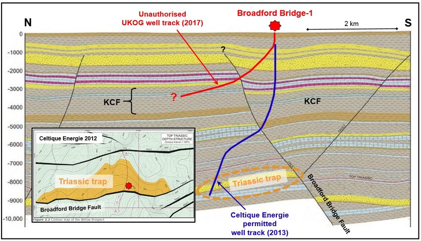
4.7.3. UKOG Broadford Bridge
Celtique Energie identified the ‘Willow Prospect’ in 2012 in PEDL 234. This is a conventional
hydrocarbon trap, with the reservoir being prognosed as Sherwood Sandstone (Triassic age) atInt. J. Environ. Res. Public Health 2020, 17, 6946 17 of 60
7000–8000 ft (2.1–2.4 km) depth. It lies to the north of, and is bounded by, the Broadford Bridge
Int. J. Environ. Res. Public Health 2020, 17, x 17 of 59
Fault (Figure 5). The proposed site was one of seven possibilities examined in the Alternative Sites
Assessment.
Assessment. Because
Becausethe thetrap
trapisisfinite
finitein
inextent
extent there is aa limited
there is limitedarea
areawithin
withinwhich
whichsurface
surface sites
sites forfor
drilling may be searched
drilling may be searched for. for.
Figure North–south
5. 5.
Figure North–southgeological
geologicalcross-section
cross-section through the Broadford
through the BroadfordBridge-1
Bridge-1well
welldrilled
drilledbyby UKOG
UKOG
in 2017. Vertical scale is shown in feet. The MPA-permitted well track of Celtique Energie
in 2017. Vertical scale is shown in feet. The MPA-permitted well track of Celtique Energie is shown is shown
in
in blue;
blue; the approximate track of the unauthorised well drilled by UKOG in 2017 is shown in red. in
the approximate track of the unauthorised well drilled by UKOG in 2017 is shown red.
The
Theinset
inset map shows the structure map of the Triassic trap named ‘Willow’ by Celtique
map shows the structure map of the Triassic trap named ‘Willow’ by Celtique Energie. Energie.
UKOGUKOG took
took overoverPEDL234
PEDL234from fromCeltique
Celtique in in June
June 2016.
2016. ItIt intended
intendedtotoexplore
exploreforforhydrocarbons
hydrocarbons
in aincompletely different manner. Firstly, in contrast to Celtique’s well-defined conventional
a completely different manner. Firstly, in contrast to Celtique’s well-defined conventional target, target,
thethe
Applicant’s
Applicant’s target,
target,thetheKimmeridge
KimmeridgeClay ClayFormation
Formation (KCF),
(KCF), is is found
foundbelow
belowthe
thewhole
wholeofof thethe licence
licence
area. The Initial Drilling Application [68]
area. The Initial Drilling Application [68] to the to the OGA confirms that the target was anticipated to to
confirms that the target was anticipated bebe
a a
“resource or or
“resource continuous
continuous oiloil
deposit,
deposit,without
withoutaastructural
structural closure”. Therefore,there
closure”. Therefore, therewas
wasnono geological
geological
requirement
requirement ororjustification
justificationfor forusing
usingthe
theexisting
existing well pad
pad at
at Wood
Wood Barn
BarnFarm.
Farm.ItItalso
alsofollows
follows that
that
thethe Alternative
Alternative Sites
Sites Assessmentcarried
Assessment carriedout
out byby Celtique,
Celtique, which
whichwas wasaamaterial
materialpart
partofofthe
theplanning
planning
approval,
approval, waswas superfluous,since
superfluous, sincethe
theentire
entireKCFKCFover
over the
the whole licence
licenceblock
blockhad
hadbecome
becomethe thetarget.
target.
The The
OGAOGA issued
issued a drilling
a drilling permit
permit to UKOG
to UKOG on 25 on
May252017.
May This 2017.included
This included permission
permission to
to sidetrack.
sidetrack.detailed
I provided I provided detailed
evidence evidence
to the to the EA consultation
EA consultation that UKOG was thatplanning
UKOG was planning
to breach thetoconditions
breach
the conditions
of the permit issuedof thebypermit
the MPA. issued by the MPA.the
Nevertheless, Nevertheless,
EA issued athe EA issued
permit a permit
on 6 July 2017. on 6 July 2017.
Broadford Bridge-1 was spudded on 29 May 2017, before
Broadford Bridge-1 was spudded on 29 May 2017, before the EA permit was issued, and the EA permit was issued, and
completed
completed on 29 July, the same day that the sidetrack Broadford Bridge-1z was
on 29 July, the same day that the sidetrack Broadford Bridge-1z was begun. The sidetrack was completed begun. The sidetrack
was completed on 1 September 2017, but there was a problem with the cement bonding of the casing
on 1 September 2017, but there was a problem with the cement bonding of the casing [69] and reported
[69] and reported formation damage [70]. Work stopped in March 2018 and the well was suspended.
formation damage [70]. Work stopped in March 2018 and the well was suspended. In July 2020 a
In July 2020 a third time extension was granted by the MPA for two more years, during which UKOG
third time extension was granted by the MPA for two more years, during which UKOG said it would
said it would not carry out any new work, but would compare the Broadford Bridge results with its
not carry out any new work, but would compare the Broadford Bridge results with its other sites in
other sites in Surrey [71].
Surrey [71].
4.7.4. UKOG Horse Hill
4.7.4. UKOG Horse Hill
PEDL137 was awarded to Magellan Petroleum in the 12th onshore licensing round in 2004. A
PEDL137 was awarded to Magellan Petroleum in the 12th onshore licensing round in 2004.
planning application to drill Horse Hill-1 (labelled HH in Figure 3b) was submitted Surrey County
A planning application
Council (SCC; Mineraltoand
drillWaste
Horse Hill-1 (labelled
Application HH ininFigure
RE10/2089) 3b) was submitted
2010. Planning permissionSurrey
to drillCounty
was
Council
granted(SCC;
by onMineral and2012
16 January Waste Application
following RE10/2089)
a favourable OfficerinReport
2010. dated
Planning permission
9 November 2011.toThe
drill
Officer Report summarised the geology behind the proposal as follows:You can also read