Independent Review of Flood Modelling - Narromine to Narrabri Inland Rail Project
←
→
Page content transcription
If your browser does not render page correctly, please read the page content below
Independent Review of Flood Modelling
Narromine to Narrabri Inland Rail Project
Holding Redlich
1283-03-B [DRAFT], 19 February 2021
Report Title                 Independent Review of Flood Modelling
 Client                       Holding Redlich
 Report Number                1283-03-B [DRAFT]

 Revision Number                  Report Date                      Report Author                    Reviewer
 0                                19 February 2021                 GR

For and on behalf of WRM Water & Environment Pty Ltd
Level 9, 135 Wickham Tce, Spring Hill
PO Box 10703 Brisbane Adelaide St Qld 4000
Tel 07 3225 0200

Greg Roads
Senior Principal Engineer

NOTE: This report has been prepared on the assumption that all information, data and reports provided to us by our client, on
behalf of our client, or by third parties (e.g. government agencies) is complete and accurate and on the basis that such other
assumptions we have identified (whether or not those assumptions have been identified in this advice) are correct. You must
inform us if any of the assumptions are not complete or accurate. We retain ownership of all copyright in this report. Except
where you obtain our prior written consent, this report may only be used by our client for the purpose for which it has been
provided by us.

wrmwater.com.au                                                          1283-03-B [DRAFT] | 19 February 2021 | Page 2
Contents
1   Introduction ___________________________________________________________ 4
    1.1 Background _______________________________________________________________ 4
    1.2 NSW Farmers and CWA concerns _____________________________________________ 4
    1.3 Scope of services __________________________________________________________ 5
2   Design requirements, standards and guidelines _______________________________ 6
    2.1 Overview _________________________________________________________________ 6
    2.2 Quantitative design objectives _______________________________________________ 6
3   Design discharge estimates _______________________________________________ 8
    3.1 Overview _________________________________________________________________ 8
    3.2 Macquarie River / Castlereagh River __________________________________________ 8
    3.3 Creek catchment flows _____________________________________________________ 8
    3.4 Summary of findings _______________________________________________________ 9
4   Flooding assessment ___________________________________________________ 10
    4.1 Overview ________________________________________________________________ 10
    4.2 Model methodology _______________________________________________________ 10
    4.3 Flood level impacts _______________________________________________________ 11
    4.4 Changes to flow patterns __________________________________________________ 11
          4.4.1 Macquarie River / Webb’s Siding ______________________________________ 11
          4.4.2 Creek catchments ___________________________________________________ 12
    4.5 Flood velocity impacts_____________________________________________________ 12
          4.5.1 Erosion potential____________________________________________________ 12
          4.5.2 Creek erosion impacts _______________________________________________ 12
          4.5.3 Overbank erosion impacts ____________________________________________ 14
    4.6 Impact of blockage _______________________________________________________ 14
5   Summary of findings____________________________________________________ 15
6   References ___________________________________________________________ 17

List of Figures
Figure 4.1 – Change in peak flood level at Tomingley Road crossing to the south of Narromine 13

List of Tables
Table 2.1 – Quantitative design objectives ................................................................. 6
Table 3.1 – EIS design discharge estimate comparison to RFFE estimates, Wallaby Creek
    Tenandra Creek and Gulargambone Creek ............................................................ 9

wrmwater.com.au                                              1283-03-B [DRAFT] | 19 February 2021 | Page 3
1 Introduction
1.1 BACKGROUND
The Australian Rail Track Corporation Ltd (ARTC) (‘the proponent’) is seeking approval to
construct and operate the Narromine to Narrabri (N2N) section of Inland Rail (‘the proposal’).
The proposal consists of about 306 kilometres of new single-track standard gauge railway with
crossing loops. The proposal includes major river crossings of the Macquarie River (Narromine),
Castlereagh River (near Curban) and the Namoi River (Narrabri) as well as over 100 creek
crossings.
The proposal is State significant infrastructure and is subject to approval by the NSW Minister
for Planning and Public Spaces under the NSW Environmental Planning and Assessment Act 1979
(EP&A Act). The proposal is also determined to be a controlled action under the Commonwealth
Environment Protection Biodiversity and Conservation Act 1999 (EPBC Act) and requires
approval from the Australian Minister for the Environment.
JacobsGHD IR Joint Venture (JacobsGHD) have undertaken hydrological and hydraulic modelling
of the various waterways that cross the proposed rail as part of the Environmental Impact
Statement (EIS) prepared by ARTC to support the application. Design discharges were estimated
for a wide range of flood events from the 20% Annual Exceedance Probability (AEP) event up to
the Probable Maximum Flood (PMF) event using both calibrated and uncalibrated hydrological
models. Fourteen hydraulic models were developed to estimate design flood levels, depths and
velocities for existing conditions, construction conditions and proposed conditions as well as
assess the impact of the proposed rail.
1.2 NSW FARMERS AND CWA CONCERNS
I have been advised that the NSW Farmers and CWA members have numerous concerns regarding
the N2N Project and the explanations/justifications put forward in the EIS, including in relation
to the flooding and hydrology impacts from the proposal. They have specific concerns with two
flood prone areas:
1. To the east of Narromine near Webb’s Siding and Backwater Cowal (Webb’s Siding). NSW
Farmers and CWA members suggest that this area is an important relief valve to reduce
flooding in Narromine during large flow events. They have concern that the alignment will
act as a semi-impermeable barrier and prevent the waters escaping to the north east;
2. To the west of the Warrumbungle Ranges (from the Castlereagh River Bridge north to the
Baradine Crossing Loop (Warrumbungles Watershed).
Landholders in Warrumbungles Watershed report that relatively short duration but intense
rainfall events in the Warrumbungles give rise to what they describe as a sheet of water
between 40-60cm deep moving over the land. This water has a tendency to only pool for a short
duration before soaking away into the subsurface soil. Where there has been a prolonged wet
period, the water pools to a much larger extent than indicated in the ARTC modelling.
The NSW Farmers and CWA members are concerned that the flooding and hydrology modelling
for the N2N Project significantly underestimates the amount of water in these areas.
The underestimating of flows raises concerns that the number, extent and location of bridging
and culverts will not be sufficient to accommodate the anticipated flows, leading to concerns
that there will be consequential changes to flow patterns, as well as depth and velocity of
flows.
Due to the nature of the farming operations in the area (principally dry land cropping and
grazing), there is also a lot of stubble that moves across the water during flow events. The
landowners are concerned that modelling does not sufficiently account for the frequency and
extent of blockages where culverts, rather than bridges, are being proposed.
wrmwater.com.au 1283-03-B [DRAFT] | 19 February 2021 | Page 4If this is the case, and the flooding and hydrology modelling is inaccurate or insufficient, then a
question also arises as to whether alternative routes should have been selected to avoid the
worst of the flood affected land.
Additionally, the landowners do not believe that the erosive nature of the ‘black soils’, which
are highly erodible, have been adequately considered in the EIS documentation.
1.3 SCOPE OF SERVICES
I have been engaged by Holding Redlich, on behalf of NSW Farmers and the CWA, to provide an
opinion on the adequacy and accuracy of the ARTC’s flooding and hydrology modelling for the
N2N Project in relation to the above matters. More specifically, I have been requested to:
• undertake a desktop review of the assumptions which underpin the analysis in the EIS and
confirm whether these assumptions are appropriate; and
• consider whether the assumptions underpinning the EIS justify the conclusions reached in
the EIS regarding the impacts and whether they are acceptable.
This report has been prepared on the basis of information provided in the EIS.
No independent hydrologic or hydraulic modelling has been undertaken by WRM as part of this
review. Further, this review has been limited only to flood modelling undertaken in the two
specific areas of concern (Webb’s Siding and the Warrumbungle Watershed).
wrmwater.com.au 1283-03-B [DRAFT] | 19 February 2021 | Page 52 Design requirements, standards and
guidelines
2.1 OVERVIEW
The Secretary’s Environmental Assessment Requirements (SEARs) for the NSN Project are
detailed in Appendix A of the EIS. The SEARs key issues with respect to flooding are tabulated in
Table A2 Section 9. Of relevance to this review, the SEARs require the proponent to “develop
and justify quantitative design limits on potential adverse flooding, hydrological and
geomorphological impacts resulting from the project. These are to consider land use and
include afflux, velocity, extent, duration, hazard, scour potential, etc”.
2.2 QUANTITATIVE DESIGN OBJECTIVES
Table 2.1 shows the quantitative design objectives adopted by ARTC for the proposed rail.
These quantitative design objectives apply outside the rail corridor for events up to and
including the 1% AEP flood event. The following comments are made regarding the adopted
design objectives.
• The afflux, flood hazard and flood duration design objectives would appear reasonable.
• The scour/erosion potential design objectives are vague. Further discussion on
erosion/design objectives is given in Section 4.5.
• No design objectives have been provided to minimise the changes in the distribution of
flow. Further discussion on changes in the distribution of flow is given in Section 4.4.
• No consideration has been given to uncertainty and model sensitivity.
Table 2.1 – Quantitative design objectives
Parameter Location or land use Quantitative design objective
Afflux Habitable floor/Sensitive 10 mm
infrastructure
Other urban and recreational 200 mm
Agriculture 200 mm
Forest and unimproved grazing 400 mm
Highways and sealed roads >80Parameter Location or land use Quantitative design objective
Flood Habitable floors Less than 10% change in duration of
duration inundation where there is above floor
flooding
Highways and sealed roads Minimise changes to accessibility during
>80km flood events.
Elsewhere Minimise changes based on an assessment
of risk with a focus on land use and flood
sensitive receptors.
wrmwater.com.au 1283-03-B [DRAFT] | 19 February 2021 | Page 73 Design discharge estimates 3.1 OVERVIEW The EIS does not provide sufficient information to undertake an independent peer review of the methodology used to derive design discharges draining to each waterway crossing. The EIS provides a brief description of the methodology used but no details of the hydrological model configuration, model parameters, validation methodology or results have been provided. Outlined below is a review of the design discharge estimates, which are provided in the EIS in Table C-1 of Appendix C of the Technical Report 3. The review is based on an interpretation of the brief descriptions of the methodologies given in Technical Report 3 (Flooding and hydrology assessment) and an independent analysis of selected waterways in the two areas of interest. 3.2 MACQUARIE RIVER / CASTLEREAGH RIVER The EIS states that design discharges in the major watercourses were derived from at site flood frequency analysis (FFA) of the historical flows recorded at the available stream gauges. RORB rainfall runoff routing models were developed of these catchments to convert the peak discharges to a discharge hydrographs. The adopted methodology to estimate flows for the major catchments is reasonable. However, no information has been provided in the EIS to review or provide comment on the assumptions made in the FFA or RORB modelling. The peer review, undertaken by BMT and provided in Appendix B of Technical Report 3, provides some commentary regarding the model parameters but insufficient to undertake an independent review. There is considerable uncertainty surrounding the Macquarie River design discharges because it was derived from an FFA of only 32 years of recorded data at the Baroona gauge (GS421127) with design discharges extrapolated out for the larger floods. There is a high level of uncertainty when the FFA is extrapolated to estimate design discharge for larger events such as the 1% AEP event. Notwithstanding this, the peer reviewer noted that the design discharges are similar to the design discharges determined by Lyall & Associates (2009) who prepared the Narromine Floodplain Risk Management Study and Plan for Narromine Shire Council. The rigour undertaken to derive these design discharges for this study is not known. No data has been provided, or is publicly available, to determine the appropriateness of the adopted Castlereagh River design discharges. 3.3 CREEK CATCHMENT FLOWS The EIS states that design discharges for the creek catchments crossing the rail line were determined by the development of RORB rainfall runoff routing models. No details on the configurations of the models were provided. The EIS states that RORB parameters were adopted from recommendations in Australian Rainfall and Runoff (ARR) (Ball et al, 2019). For ungauged catchments, such as all of the catchments within the two areas of interest (Webb’s Siding and Warrumbungles Watershed), ARR provides regional recommendations for the RORB kc parameter Whilst this methodology is reasonable, the appropriateness of the kc value is dependent upon the configuration of each model, which has not been provided. ARR also notes that there is a high level of uncertainty in the discharge estimates using the regional parameter even when a consistent and appropriate model configuration has been used. ARR provides an alternative method to estimate flows for ungauged catchments using the Regional Flood Frequency Estimation (RFFE) technique (ARR, 2021). RFFE is based on data from 853 gauged catchments across Australia. Given the lack of good quality stream gauge data in this area, there would be a similar level of uncertainty surrounding RFFE flow estimates. wrmwater.com.au 1283-03-B [DRAFT] | 19 February 2021 | Page 8
Notwithstanding the uncertainties, a comparison of the design discharge estimates at three
locations along the rail is shown in Table 3.1. For reference, Wallaby Creek is a local
catchment draining to the Backwater Cowal near Webb’s Siding to the east of Narromine.
Tenandra Creek and Gulargambone Creek are located within the Warrumbungles Watershed.
The following is of note:
    • The EIS design discharges are higher than RFFE design discharges for Wallaby Creek.
    • The EIS design discharges are lower than RFFE design discharges for Tenandra Creek.
    • The EIS design discharges are substantially higher than RFFE design discharges for
      Gulargambone Creek.

Table 3.1 – EIS design discharge estimate comparison to RFFE estimates, Wallaby Creek
Tenandra Creek and Gulargambone Creek

 AEP                 Wallaby Creek          Tenandra Creek         Gulargambone
                     (m3/s)                 (m3/s)                 Creek (m3/s)
                     EIS        RFFE        EIS        RFFE        EIS         RFFE
 20%                 224        88          58         58          184         82
 5%                  348        204         106        136         354         190
 2%                  420        314         133        209         490         294
 1%                  480        420         160        280         567         393

It is not possible to discern the reasons for the differences from the information provided in the
EIS. However, with neither methodology predicting consistently higher or lower discharges even
for catchments relatively close to each other, the inconsistency should be investigated as it may
be related to poor model setup. At the very least, the higher of the two regional estimates
should be adopted given the uncertainty surrounding the estimates.

3.4     SUMMARY OF FINDINGS
There is not sufficient information provided in the EIS to undertake an independent peer review
of the methodology used to derive design discharges draining to each waterway crossing. From
the information that has been provided:
    • The general methodology adopted to undertake the design discharge estimates for both
      the gauged and ungauged waterways is appropriate. However, no information has been
      provided to determine whether the methodologies have been implemented
      appropriately.
    • The design discharges adopted for the Macquarie River were reported to be consistent
      with the design discharges estimated for the Narromine Flood Study by Lyall & Associates
      (2009), which provides some confidence in the Macquarie River discharge estimates.
    • No information has been provided or is publicly available to determine whether the
      Castlereagh River discharges have been determined correctly or are appropriate.
    • For the ungauged creek catchments, which is most of the waterway crossings along the
      rail, RORB models using regional parameters were used in the EIS to derive peak
      discharges. This methodology is appropriate but has a high level of uncertainty.
    • A comparison of the RORB design discharges to design discharges estimated using an
      alternative regional methodology (RFFE) at three selected waterways showed significant
      differences. One methodology did not consistently produce higher estimates that the
      other, which could suggest some issues with the adopted RORB model configurations.
      Given the uncertainty surrounding the estimates, both methods should be used and the
      higher of the two adopted.

wrmwater.com.au                                        1283-03-B [DRAFT] | 19 February 2021 | Page 9
4 Flooding assessment
4.1 OVERVIEW
Fourteen TUFLOW hydraulic models were developed for the EIS to define the flooding behaviour
along the rail. The models were developed for existing conditions and for proposed rail
conditions. The EIS provides details of the culvert and bridge crossings of the various waterways
(Table A-1 of Appendix A of Technical Report 3) and provides flood mapping for events ranging
from the 20% AEP (approximately the 5 year average recurrence interval (ARI) event), 5% AEP
(20 year ARI), 2% AEP (50 year ARI), 1% AEP (100 year ARI) as well as for a number of very rare
and extreme events. Mapping was provided for:
• Existing peak flood depths and flood level contours;
• Existing peak flood velocities (20% AEP event only);
• Existing flood hazard;
• Flood level impacts (construction and operational phases);
• Flood velocity impacts;
• Flood duration impacts; and
• Flood hazard impacts.
The models were not available for review and no detail was provided on the development and
validation of the models. As a result, a detailed review of the methodology used to derive the
flood model results and the impacts at each waterway cannot be undertaken.
Outlined below is an assessment of the flood model results from the information provided.
4.2 MODEL METHODOLOGY
The following comments are provided regarding the hydraulic modelling methodology:
• The hydraulic modelling package adopted for the EIS (TUFLOW) is used widely across
Australia and is suitable to assess the impacts of the project.
• Although it is not documented, it would appear that the upper catchment inflows have
been derived using the hydrology model results and a ‘rain-on-grid’ approach has been
adopted for runoff within the modelling area. If this is the case, this methodology is
appropriate.
• The EIS states that four sets of ground level survey data were used. However, only the
Lidar data captured by AAM Pty Ltd would be appropriate to define flood levels and flood
impacts. The extent of the AAM data was not provided. The publicly available Lidar data
from the ELVIS database across the Warrumbungle Watershed has a vertical accuracy of
±1m. It would be completely inappropriate to assess flood impacts using the Elvis data.
• The hydraulic models in the Warrumbungles Reach are uncalibrated (as no data is
available).
• Ground level roughness values (Manning’s ‘n’) used in the modelling were not provided.
The adopted roughness values will change both the peak flood levels and peak flood
velocity across the floodplain and should have been provided in the EIS. At the very least,
a sensitivity analysis to changes in ground level roughness should have been undertaken.
No sensitivity analysis was documented.
• The documented methodology to model the culverts and bridges in the EIS appear
appropriate. However, no details have been provided to determined whether appropriate
wrmwater.com.au 1283-03-B [DRAFT] | 19 February 2021 | Page 10parameters have been applied other than the commentary in the peer review (Appendix
B of Technical Report 3).
4.3 FLOOD LEVEL IMPACTS
Flood level impacts were provided along the rail via a series of 14 maps covering the 306 km of
new rail. Overall, the flood mapping provided is grossly inadequate and unsuitable for an
individual farmer to identify the extent and quantity of flood level impacts at their property
because of the following:
• the mapping scale is too coarse to show the extent and location of impacts;
• the rail corridor GIS layer covers locations of the greatest flood impact;
• it is difficult to determine the locations and depths of flood level impacts in comparison
the quantitative design objectives, given in Table 2.1, from the adopted afflux colour
scheme;
• even if the difference in afflux colour for the over and above the 0.01 m impact could be
determined from the mapping, the locations of sensitive receptors that fall within the
impact zone have not been identified or shown;
• the locations where flood afflux exceeds the ‘agriculture’ quantitative design objective
of 0.2 m cannot be determined as the locations of agriculture areas are not shown; and
• the locations where flood afflux exceeds the grazing area quantitative design objective of
0.4 m in the cannot be determined because there is not an afflux colour boundary that
coincides with 0.4 m.
In the Webb’s Siding area, the mapping shows flood afflux exceeding 0.2 m for most creek
crossings between the existing rail at Narromine to the Macquarie River. The afflux exceeds
0.5 m at several locations. This suggests that more culverts are required to satisfy their own
quantitative design objective.
For the Castlereagh River, the afflux for the 1% AEP event exceed 0.2 m and this impacts 11
existing dwellings. The EIS provides no discussion as to how this impact would be mitigated but
a larger bridge opening would appear necessary.
In the Warrumbungles Watershed reach, any exceedances of the afflux quantitative design
criteria would appear to be confined to the proposed rail corridor study area corridor and
therefore very localised.
4.4 CHANGES TO FLOW PATTERNS
4.4.1 Macquarie River / Webb’s Siding
The flood mapping shows that the Macquarie River overflows into the Backwater Cowal at
Webb’s Siding for events greater than the 2% AEP event. The overflowing floodwater drains
along the Backwater Cowal and away from the Narromine township. In effect, the overflows at
Webb’s Siding are a natural flood mitigation measure for Narromine as they reduce flows
draining along the Macquarie River for rare to extreme events.
The proposed rail is located directly across the overflow path from the Macquarie River to the
Backwater Cowal. Approximately 1,650 m of viaduct is proposed across the river, existing rail,
the Mitchell Highway and the Backwater Cowal channel at this location. The proposed rail
configuration will convey the flows up to the 2% AEP event without significant changes in flow
patterns. However, there is about 1,000 m of elevated embankment in between the viaducts
and a further 1,000 m of elevated embankment to the south of the Backwater Cowal that would
obstruct the overflows and divert flows back along the Macquarie river for the larger events.
The EIS predicts that the change in flows due to the proposed rail would increase above floor
flooding to 605 dwellings in Narromine for the 1% AEP plus climate change event and 2,520
dwellings for the 0.2% AEP event. This is a poor outcome for Narromine.
wrmwater.com.au 1283-03-B [DRAFT] | 19 February 2021 | Page 11It would appear that there are two options to reduce the impacts:
• Realign the rail away from Webb’s Siding; or
• Extend the viaduct to reduce the embankment sections by an additional 2 km.
Further to this, the existing rail between Dubbo and Narromine may also be preventing the
Macquarie River from overflowing into the Backwater Cowal and diverting flows into Narromine
for the more frequent events. The construction of the inland rail would appear to provide
opportunity to increase the waterway opening of the existing rail to mitigate flooding in
Narromine.
4.4.2 Creek catchments
The flood mapping shows changes to flow patterns along much of the rail alignment for all flood
events investigated from the 20% AEP (frequent) event to the extreme events. The changes to
the flow patterns occur in areas of very flat topography such as:
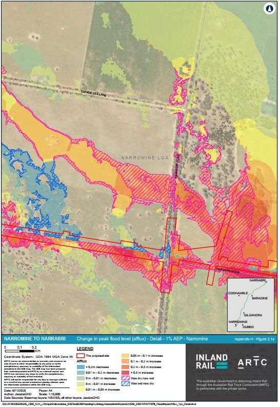
• to the south of Webb’s Siding along Wallaby Creek and its tributaries (see Figure 4.1);
• to the south of the Castlereagh River to Nancarrows Road (N2N11N12 flood model);
• along the Gulargambone Creek tributaries (N2N10 flood model); and
• along Box Ridge Road to the north of Baronne Creek (N2N9 model).
The impact of these changes will vary at each individual property as it depends on the site
infrastructure such as fences and whether the individual paddocks are cropped. Figure 4.1
shows a high resolution image of the changes in flow patterns that are predicted to the west of
Wallaby Creek along Tomingley Road (to the south of Narromine). This figure was extracted
from Appendix F of Technical Report 3. The figure shows that the changed flows would increase
frequency and depth of flooding at a house and shed as well as along boundary fences. It is not
possible to show the impacts at other locations because of the quality of the flood mapping, as
described above.
Overall, it suggests that there are insufficient culvert locations to prevent changes in the
distribution in flow at this location, and potentially at many other locations. It is suggested that
ARTC engage with each landholder with higher resolution maps to explain the predicted impacts
and attempt to address any concerns.
4.5 FLOOD VELOCITY IMPACTS
4.5.1 Erosion potential
The EIS includes a geomorphic characterisation of the various waterways that cross the
proposed rail based on the River Styles framework. The characterisation has been used to assess
the existing erosion potential of the waterways and assist in assessment the erosion risk of the
project. The assessment found that most waterways that cross the proposed rail are in a
moderate to poor geomorphic condition and all waterways have a moderate to high fragility.
This means that the watercourses, particularly those within the Warrumbungles Watershed, are
prone to erosion and sedimentation, have catchments that produce high sediment loads and
there is little vegetation along the waterways to prevent accelerated rates of erosion.
The soils of the Warrumbungle Watershed soils were also identified as predominantly Vertosol
soils to the north of Gulargambone Creek and Kandosol soils to the north. Vertosol soils are
cracking clays that have a high erosion potential. Kandosol soils are generally sandy and
susceptible to rill, sheet and stream bank erosion.
4.5.2 Creek erosion impacts
The geomorphic characterisation was used to define the expected bedform types of each
waterway and a literature search was undertaken to define the maximum velocity prior to
which the various bed forms would erode.
wrmwater.com.au 1283-03-B [DRAFT] | 19 February 2021 | Page 12House Figure 4.1 – Change in peak flood level at Tomingley Road crossing to the south of Narromine wrmwater.com.au 1283-03-B [DRAFT] | 19 February 2021 | Page 13
Maximum velocity thresholds were defined for three typical bedform types:
    • 0.5 m/s for sandy loam;
    • 0.8 m/s for fine gravels; and
    • 2 m/s for vegetated surfaces.

The hydraulic model was used to assess the changes in velocity due to the project and the
potential impact this would have on the geomorphological condition of the waterway. That is,
will the channels degrade as a result of the proposed rail. The results are presented as a series
of figures (Figure 7.11 to Figure 7.14) in Technical Report 3 showing the change in maximum
velocity at a single point in each waterway.
These figures are misleading and more than likely wrong. For instance, about 25 of the
waterways show a reduction in 5% AEP velocity due to the rail, some are substantial reductions.
More than a 50% reduction was predicted for the large waterways of the Macquarie River and
Castlereagh River for the 5% AEP event, which is clearly wrong. If this was true, significant and
unacceptable changes to the waterways would occur.
It would be expected that a minor increase in velocity would occur upstream of the rail (due to
the afflux) and an increase in velocity downstream due to the confinement of the flows. The
use of a single, undefined point at the rail with inconsistent results provides no confidence that
an appropriate analysis has been undertaken.

4.5.3 Overbank erosion impacts
The EIS provides existing conditions velocity maps for the 20% AEP event only. For this event,
the mapping colour scheme shows most overbank velocities below 1 m/s. This scale is too
coarse to determine where existing condition scour would occur on the sandy loam soils and the
vertosol soils (which would erode at 0.5 m/s). Much of the Warrumbungles Watershed contains
vertosol soils.
Maximum velocity maps along the waterways and overbank areas for the other events were not
provided and as such the existing erosion potential of the overbank areas is not known. Also,
maximum velocities under the proposed conditions were not provided for any events and
velocity impact maps showing impacts between 0.1 m/s and 0.5 m/s cannot be used to
determine whether the increase as risen above the thresholds at which erosion would occur.
In other words, it is not possible to determine whether the proposed rail would cause increased
soil erosion in the overbank areas.

4.6     IMPACT OF BLOCKAGE
The EIS states that a blockage assessment was undertaken in accordance with ARR (Ball et al,
2019) recommendations. However, no mapping or results were provided to demonstrate the
impacts. Note that the EIS states that a blockage factor of 100% was recommended at Mt
Tenandra, within the Warrumbungles Watershed, using the ARR risk assessment. Given that
Tenandra Creek was identified as having a discontinuous river style (highly erosive) and has
vertosol soils (also highly erosive), it could be concluded that significant erosion would occur if
the waterway opening was blocked.
Blockage factors for the other waterways within the Warrumbungles Watershed was not
provided. However, it could be expected that similar blockage factors and subsequent erosion
would be encountered.

wrmwater.com.au                                        1283-03-B [DRAFT] | 19 February 2021 | Page 14
5 Summary of findings
Technical Report 3 of the EIS prepared by ARTC for the Narromine to Narrabri section of the
inland rail has been reviewed to provide an opinion on the adequacy and accuracy of the
flooding and hydrology modelling and whether the conclusions reached in the EIS are
acceptable. The review is limited to the flood modelling undertaken in the two specific areas of
concern (Webb’s Siding and the Warrumbungle Watershed). My conclusions of the review are as
follows:
• The quantitative design objectives adopted by ARTC are reasonable for afflux, flood
hazard and flood duration. The scour/erosion potential design objectives are vague and
no design objectives have been provided to minimise the changes in the flow patterns.
• With respect to the estimated design flows used for the assessment:
o The adopted Macquarie River flows are consistent with those adopted by Narromine
Shire and would therefore appear reasonable.
o A review of the Castlereagh River flows cannot be undertaken because no
information was provided.
o The Warrumbungle Watershed creek flows have been derived using regional
relationships because there is no historical data to base the flow estimates on. No
information has been provided to determine whether the approach used to
determine the flows is reasonable. However, a comparison to predicted discharges
using another regional method showed significant differences and no bias high or
low. Given the uncertainty surrounding the estimates, both methods should be used
and the higher of the two adopted.
• The models and methodology used to estimate flood levels, velocities and flood impacts
of the rail is appropriate.
• With respect to the flood level impacts (afflux):
o The flood mapping provided is grossly inadequate and unsuitable for an individual
farmer to identify the extent and quantity of flood level impacts at their property.
o In the Webb’s Siding area (where detailed mapping is available), the predicted flood
afflux exceeds 0.2 m for most creek crossings and exceeds 0.5 m at several
locations. This suggests that more culverts are required to satisfy the ARTC
quantitative design objective.
o For the Castlereagh River, the afflux would exceed 0.2m for the 1% AEP event and
impact 11 existing dwellings. The EIS provides no discussion as to how this impact
would be mitigated but it would appear a larger bridge is required.
o In the Warrumbungles Watershed reach, any exceedances of the afflux quantitative
design criteria would appear to be confined to the proposed rail corridor study area
corridor and therefore very localised.
• The proposed rail is located directly across the overflow path from the Macquarie River
that directs floodwater around Narromine during rare flood events. The change in the
distribution in flow due to the proposed rail would increase above floor flooding to 605
dwellings in Narromine for the 1% AEP plus climate change event and 2,520 dwellings for
the 0.2% AEP event. Additional viaduct or an alternative rail location would be required
to mitigate the impacts at Narromine.
• Changes to flow patterns are predicted along much of the rail alignment for all flood
events investigated. The changes to the flow patterns occur in areas of very flat
topography both in the Webb’s Siding area and the Warrumbungles Watershed. It is
difficult to determine the impact of this change with the available flood mapping. It is
wrmwater.com.au 1283-03-B [DRAFT] | 19 February 2021 | Page 15suggested that ARTC engage with each landholder with higher resolution maps to explain
the predicted impacts and attempt to address any concerns.
• The assessment undertaken to predict the erosion impacts of the waterways appears
misleading and likely wrong. For instance, more than a 50% reduction was predicted for
the large waterways of the Macquarie River and Castlereagh River for the 5% AEP event,
which is clearly wrong. If this was true, significant and unacceptable changes to the
waterways would occur. The assessment provides no confidence that an appropriate
analysis of the impact to the waterways has been undertaken.
• The flood mapping provided cannot be used to determine whether the changes in flow
patterns would cause overbank erosion. Velocity maps were only provided for the 20%
AEP event under existing conditions and the velocity colour scheme cannot be used to
determine whether these velocities would cause erosion, particularly in the areas
containing vertosol soils in the Warrumbungle Watershed.
wrmwater.com.au 1283-03-B [DRAFT] | 19 February 2021 | Page 166 References
ARR (2021) AR&R Regional Flood Frequency Estimation Model (software),
Engineers Australia and Western Sydney University, Version 2019_v1,
2021, .
Ball et al. (2019) ‘Australian Rainfall and Runoff: A Guide to Flood Estimation’, Ball J,
Babister M, Nathan R, Weeks W, Weinmann E, Retallick M, Testoni I,
(Editors) Commonwealth of Australia (Geoscience Australia), 2019.
Lyall & Associates ‘Narromine Floodplain Risk Management Study and Plan’ prepared by
(2009) Liall & Associates for Narromine Shire Council November 2009
wrmwater.com.au 1283-03-B [DRAFT] | 19 February 2021 | Page 17You can also read