Initial soil moisture retrievals from the METOP-A Advanced Scatterometer (ASCAT)
←
→
Page content transcription
If your browser does not render page correctly, please read the page content below
GEOPHYSICAL RESEARCH LETTERS, VOL. 34, L20401, doi:10.1029/2007GL031088, 2007

Initial soil moisture retrievals from the METOP-A Advanced
Scatterometer (ASCAT)
Zoltan Bartalis,1 Wolfgang Wagner,1 Vahid Naeimi,1 Stefan Hasenauer,1 Klaus Scipal,2
Hans Bonekamp,3 Julia Figa,3 and Craig Anderson3
Received 22 June 2007; revised 31 July 2007; accepted 11 September 2007; published 16 October 2007.

[1] This article presents first results of deriving relative              in situ soil moisture observations [Ceballos et al., 2005],
surface soil moisture from the METOP-A Advanced                           and runoff [Scipal et al., 2005]. The dataset is also com-
Scatterometer. Retrieval is based on a change detection                   plementary to the series of GRACE gravitational observa-
approach which has originally been developed for the Active               tions related to the dynamics of the continental water
Microwave Instrument flown onboard the European satellites                storage [Wahr et al., 2004].
ERS-1 and ERS-2. Using model parameters derived from                        [3] With the recent launch of the first of three METOP
eight years of ERS scatterometer data, first global soil                  satellites in October 2006, the Advanced Scatterometer
moisture maps have been produced from ASCAT data. The                     (ASCAT) instrument takes over and enhances the role of
ASCAT data were distributed by EUMETSAT for validation                    the ERS scatterometers by adding the operational aspect of
purposes during the ASCAT product commissioning                           the service [Klaes et al., 2007]. Despite changes in the
activities. Several recent cases of drought and excessive                 design and the availability of a second swath, ASCAT is
rainfall are clearly visible in the soil moisture data. The               similar to the ERS scatterometer [e.g., Gelsthorpe et al.,
results confirm that seamless soil moisture time series can be            2000]. Therefore, soil moisture algorithms developed for
expected from the series of two ERS and three METOP                       the ERS scatterometer are expected to be directly transfer-
scatterometers, providing global coverage on decadal time                 able to ASCAT, requiring only minor adaptations of the
scales (from 1991 to about 2021). Thereby, operational, near-             processing chain and configuration. Hence, using ASCAT
real-time ASCAT soil moisture products will become                        commissioning data, a first test of the applicability of the
available for weather prediction and hydrometeorological                  soil moisture retrieval method proposed by Wagner et al.
applications. Citation: Bartalis, Z., W. Wagner, V. Naeimi,               [1999] could be performed. In this paper, the retrieval
S. Hasenauer, K. Scipal, H. Bonekamp, J. Figa, and C. Anderson            method is shortly described, followed by some first exam-
(2007), Initial soil moisture retrievals from the METOP-A                 ples of composite images of ASCAT-based soil moisture
Advanced Scatterometer (ASCAT), Geophys. Res. Lett., 34,                  and its anomaly compared to corresponding images of
L20401, doi:10.1029/2007GL031088.                                         precipitation or NDVI anomalies, thereby confirming some
                                                                          recent cases of extreme rain events or droughts.
1. Introduction
  [2] The primary objective of spaceborne scatterometers                  2. Scatterometers and Soil Moisture
(real aperture radar instruments) is wind retrieval over                     [4] Both the ERS scatterometer and ASCAT are real-
oceans [Stoffelen, 1998]. When they operate over land, the                aperture radar instruments, measuring surface radar back-
backscattered signal being measured contains substantial                  scatter with very good radiometric accuracy and stability.
information about soil moisture, among others [Ulaby et al.,              They produce backscatter measurements with a spatial
1982]. Several authors have proposed methods for retrieving               resolution of circa 50 km and a good radiometric resolution
soil moisture from coarse-resolution (50 km) scatterometer                [Figa-Saldaña et al., 2002], using VV polarization in the
data as provided by the European satellites ERS-1 and ERS-                C-band (5.255 GHz).
2 [Magagi and Kerr, 2001; Pulliainen et al., 1998; Wen and                   [5] ASCAT transmits linear frequency-modulated pulses
Su, 2003; Woodhouse and Hoekman, 2000; Zine et al.,                       (‘‘chirp’’) with a markedly longer duration of around 10 ms
2005]. Using the change detection approach suggested by                   at a relatively low peak power of 120 W [Gelsthorpe et al.,
Wagner et al. [1999], the first global, multi-year soil                   2000]. ASCAT measures on both sides of the subsatellite
moisture data set was derived by Scipal [2002]. Various                   track, producing two swaths of data. This double swath and
studies showed that this data set reflects trends in precipi-             the fact that it operates continuously, give more than twice
tation [Fontaine et al., 2007; Wagner et al., 2003], modeled              the coverage (almost daily) of that provided by the ERS
soil moisture [Dirmeyer et al., 2004; Pellarin et al., 2006],             scatterometers. For each pass above an observed location
                                                                          within the swath(s), both the ASCAT and ERS scatterometers
                                                                          produce a triplet of s 0 backscattering coefficients, from the
   1
      Institute of Photogrammetry and Remote Sensing, Vienna University   three different antenna beams. A s 0 measurement is the
of Technology, Vienna, Austria.                                           result of averaging several radar echoes, which in the case
    2
      European Centre for Medium-Range Weather Forecasts (ECMWF),
Reading, U. K.
                                                                          of 50 km resolution products is resampled to a 25 km grid in
    3
      European Organisation for the Exploitation of Meteorological        the swath geometry. A similar higher resolution product
Satellites (EUMETSAT), Darmstadt, Germany.                                (circa 30 km) is produced from ASCAT, in this case on a
                                                                          12.5 km swath grid.
Copyright 2007 by the American Geophysical Union.
0094-8276/07/2007GL031088

                                                                   L20401                                                         1 of 5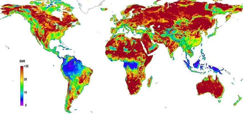
L20401                       BARTALIS ET AL.: INITIAL ASCAT SOIL MOISTURE RETRIEVALS                                   L20401

Figure 1. Map illustrating the performance of the soil moisture retrieval method. The signal-to-noise ratio (SNR) is
defined as the ratio between the sensitivity to soil moisture (the difference between wet and dry reference values) and the
yearly mean noise of s0 normalized to 40° incidence angle.

  [6] Due to the antenna design, the three (fore, mid and aft     inherent in the antecedent values of the same time series
beam) measurements are made at a 45°, 90° and 135°                [Ceballos et al., 2005]. A complete characterization of the
azimuth angle with respect to the satellite track (on each        error propagation is also done in the course of the different
side in the case of ASCAT). The fore and aft beam                 algorithm steps.
measurements are made under equal incidence angle ranges,            [7] Figure 1 illustrates the global performance of the
while the mid-beam measurements have slightly lower               method by using a signal-to-noise ratio (SNR) index. This
incidence angle range. The ability to register backscatter        relative index represents the ratio of sensitivity to soil
at various incidence angles makes it possible to determine        moisture (measured as the difference between the wet and
the yearly cycle of the backscatter-incidence angle relation-     dry references) and the mean noise of backscatter coeffi-
ship, an essential prerequisite for correcting seasonal           cient s 0 normalized to a 40° incidence angle. High SNR
vegetation effects. Although current understanding of the         characterizes areas particularly suitable for soil moisture
theoretical aspects of the attenuation of microwaves by           retrieval (grasslands, savannas, tundra, agricultural land,
vegetation is rather poor, various experimental studies           etc.). In spite of high SNR values, special care has to be
[e.g., Brown et al., 2003; Pulliainen et al., 1998] have          taken when working with boreal areas, where the soil
shown the presence of significant soil response at C-band         moisture information might suffer from the influence of
frequencies even in the case of vegetated areas, especially       forest canopies, ground frost and snow, water content of the
when observed at lower incidence angles. Using a time             moss and peat substrata rather than the soil itself, etc.
series-based change detection approach for soil moisture             [8] A low SNR is typically displayed by rainforests,
retrieval also proves beneficial in minimizing the vegetation     where the radar signal does not penetrate the dense vege-
influence. Once the backscatter is normalized to a standard       tation [Long and Skouson, 1996]. In such areas the sensi-
incidence angle (40°), its further variations are considered to   tivity to soil moisture is thus too small. Other low SNR
be either vegetation-induced, due to soil moisture or noise.      areas display high azimuthal anisotropy and/or volume
Soil moisture is considered to have a linear relationship to      scattering, such as sand deserts (with aligned dunes and
backscatter in the decibel space, while the noise sources         ripples), large urban areas and other regions of complex
include the instrument noise, speckle and azimuthal aniso-        topography [Bartalis et al., 2006]. In these cases, the
tropies. The surface roughness is assumed to have a               sensitivity to soil moisture might be very large (deserts),
constant contribution in time, and therefore is not accounted     but the noise induced by azimuthal effects and volume
for in the change detection algorithm. By knowing the             scattering has a stronger influence and the final SNR will be
typical yearly vegetation cycle and how it influences the         small. Summarizing Figure 1, retrieval of soil moisture is
backscatter-incidence angle relationship for each location        made impossible in areas where the SNR is less than 10 and
on the Earth, the vegetation effects can be removed,              should be used carefully in areas where SNR < 20.
revealing the soil moisture variations. As a last step, the
historically lowest and highest values of observed soil           3. Examples of Soil Moisture Extremes
moisture are assigned to the 0% (dry) and 100% (wet)
references respectively, thereby yielding time series of            [9] For the work presented in this paper, we have used
relative soil moisture percentage values for the first few        March 2007 data that was made available during the
centimeters of the soil. These values can be converted to         commissioning phase of the ASCAT instrument with
absolute soil moisture using soil properties [Wagner et al.,      retrieval model parameters (related to vegetation correction,
1999] or to profile soil moisture values by using information     the wet and dry reference, etc.) derived from historical ERS

                                                             2 of 5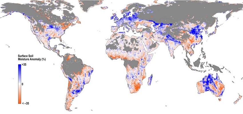
L20401 BARTALIS ET AL.: INITIAL ASCAT SOIL MOISTURE RETRIEVALS L20401
Figure 2. Surface soil moisture anomaly situation for the period 15– 21 March 2007. Blue areas are wetter than the 1992–
2000 average for that period of the year, while red areas are dryer. Areas where no soil moisture can be retrieved or where
soil moisture is meaningless (according to a snow cover climatology for the period) are masked out.
data from 1992 – 2000. The resulting ASCAT soil moisture probability of snow cover exceeds 50% for the considered
data sets are "first looks’ data and may change since the period, based on a historic analysis of SSM/I snow cover
instrument calibration-validation has yet to be finalized, data [Nolin et al., 1998]. Wetter conditions than normal are
including possible cross-calibration between ASCAT and observed in northeastern China, due to the heavy precipita-
ERS data. Improved calibration coefficients for ASCAT are tion over the North China Plain recorded a week earlier, as
expected later into the commissioning, when the complete reported by the United States Department of Agriculture
data set is planned to be reprocessed accordingly. The (USDA) Foreign Agricultural Service (FAS) (http://
overlap in time between the operation of ASCAT and the www.pecad.fas.usda.gov). The winter drought conditions
ERS-2 scatterometer will also allow for better evaluation of reported in the Chinese southeastern provinces of Guizhou
possible biases between the instruments. and Sichuan (source: Xinhua news agency), a result of
[10] Figure 2 shows the situation of the surface soil several months long lack of rainfall, are also confirmed in
moisture anomaly (compared to the 1992– 2000 mean from the image.
ERS) for a seven day period in spring 2007 (15 – 21 March). [11] A closer look at the snow-free southern hemisphere
Areas where the retrieval method cannot deliver soil mois- reveals more clearly delimited areas of rain events or
ture information (tropical forests, sand deserts, etc.) have droughts. The extremely wet conditions in northeastern
been masked out. Also masked out are areas where the Argentina and Uruguay correspond to one of the worst
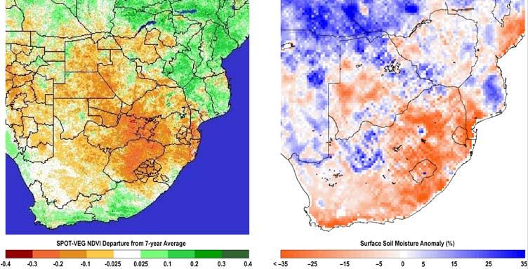
Figure 3. Comparison between (left) SPOT Vegetation NDVI (Normalized Difference of Vegetation Index) departure
from 7-year average (source: USDA Foreign Agricultural Service, http://www.pecad.fas.usda.gov/cropexplorer) and (right)
ASCAT-derived surface soil moisture anomaly for the period 21– 31 March 2007.
3 of 5L20401 BARTALIS ET AL.: INITIAL ASCAT SOIL MOISTURE RETRIEVALS L20401
Figure 4. (left) Interpolated in situ rainfall (source: Australian Government, Bureau of Meteorology, http://
www.bom.gov.au/climate) and (right) ASCAT-derived relative surface soil moisture comparison for Australia during
15– 21 March 2007.
rainy periods in the last hundred years in this region, with scale rain events especially over the arid central Australian
thousands of evacuations and almost two thirds of the regions could be sharply distinguished.
farmland devastated by mid-April (source: Financial Times
Information Limited). 4. Conclusion
[12] Also in Figure 2, severe drought is visible in southern
Africa, notably in the eastern half of South Africa. Almost [13] A first look at surface soil moisture products derived
record-high temperatures and lack of precipitation from from ASCAT data in combination with the ERS long-term
January through March caused serious crop damage and scattering parameter database show promising results in
deficiency in crop planting, as reported by USDA FAS. This observing both extreme wetness and drought. The presented
situation is also clearly shown in Figure 3, where SPOT snapshot and comparisons between the ASCAT relative
Vegetation-derived NDVI (Normalized Difference of surface soil moisture and the corresponding situation of
Vegetation Index) anomaly is compared to the ASCAT the rainfall and NDVI proxies are intended as a visual
surface soil moisture anomaly for the period 21– 31 March exercise only. Any in-depth validation would have to
2007. The overall patterns compare well, despite some local closely consider the overall spatial and temporal variability
discrepancies, partly due to the fact that NDVI anomalies of hydrological processes such as rainfall, vegetation and
are based on long-term averages over the last seven years water runoff and storage. Nevertheless, the exposed case
while the soil moisture anomalies use 1992 – 2000 as a studies illustrate well the potential of the ASCAT instrument
reference. Also, NDVI does not react quickly enough to to monitor soil moisture with an almost daily temporal
short-term soil moisture variations, which could explain sampling at a spatial resolution of 50 km or better. After
some of the discrepancies in the upper part of the images. the ASCAT commissioning, conditions will be met for
The strikingly unusual soil moisture conditions over continuing the global, long-term (30 years) soil moisture
Australia in Figure 2 are shown in detail in Figure 4 where time series, which the ERS-1 scatterometer initiated in
the ASCAT relative surface soil moisture (rather than 1991. Operational dissemination of the ASCAT Level 2
its anomaly) is compared to interpolated in situ rainfall soil moisture product by EUMETSAT is foreseen, with
measurements provided by the Australian Bureau of Mete- processing algorithms and software developed in coopera-
orology. The month of March 2007 was particularly wet tion with Vienna University of Technology (TU Wien). This
all over the Australian continent, with total precipitation service is envisaged to start operations in 2008, and will
reaching 45% above normal amounts. For the depicted provide surface soil moisture estimations on a 25 km grid in
week, three tropical cyclones (George, Jacob and Kara) the ASCAT swath, within 135 minutes of data acquisition
were responsible for the high rainfall over the central- and with global coverage. Given the limitations and caveats
northern parts of Western Australia and the Northern of both active and passive microwave remote sensing of soil
Territory. The wet area extending as a strip across Southern moisture [Kerr, 2007; Wagner et al., 2007], it is expected
Australia, visible in both the rainfall and the soil moisture that the ASCAT soil moisture service will mutually benefit
images, as well as the relatively dry conditions over parts of soil moisture observations provided by the Soil Moisture
Queensland were another feature of the month of March as a and Ocean Salinity (SMOS) mission [Kerr et al., 2001] and
whole. When surface soil moisture images of successive other passive microwave instruments [Njoku et al., 2003],
overpasses were considered (not shown here), the rainfall becoming useful for hydrology, agrometeorology, weather
related to the three above-mentioned tropical cyclones could prediction, climate research and other applications.
be easily tracked as the cyclones advanced inland from their
landfall points. Also, increase in wetness due to smaller-
4 of 5L20401 BARTALIS ET AL.: INITIAL ASCAT SOIL MOISTURE RETRIEVALS L20401
[14] Acknowledgments. This work has been supported by the Aus- Pellarin, T., et al. (2006), Evaluation of ERS scatterometer soil moisture
trian Science Fund (L148-N10), EUMETSAT (EUM/CO/05/1421/HGB, products over a half-degree region in southwestern France, Geophys. Res.
H-SAF, NWP SAF Associate Scientist Programme), and the European Lett., 33, L17401, doi:10.1029/2006GL027231.
Commission (geoland). Pulliainen, J. T., et al. (1998), Application of ERS-1 wind scatterometer
data to soil frost and soil moisture monitoring in boreal forest zone, IEEE
References Trans. Geosci. Remote Sens., 36, 849 – 863.
Scipal, K. (2002), Global soil moisture retrieval from ERS scatterometer
Bartalis, Z., et al. (2006), Azimuthal anisotropy of scatterometer measure- data, Ph.D. diss., Vienna Univ. of Technol., Vienna, Austria.
ments over land, IEEE Trans. Geosci. Remote Sens., 44, 2083 – 2092. Scipal, K., et al. (2005), Soil moisture-runoff relation at the catchment scale
Brown, S. C. M., et al. (2003), High-resolution measurements of scattering as observed with coarse resolution microwave remote sensing, Hydrol.
in wheat canopies: Implications for crop parameter retrieval, IEEE Trans. Earth Syst. Sci., 9, 173 – 183.
Geosci. Remote Sens., 41, 1602 – 1610. Stoffelen, A. (1998), Scatterometry, Ph.D. diss., Utrecht Univ., Utrecht,
Ceballos, A., et al. (2005), Validation of ERS scatterometer-derived soil Netherlands.
moisture data in the central part of the Duero Basin, Spain, Hydrol. Ulaby, F. T., et al. (1982), Microwave Remote Sensing: Active and Passive,
Processes, 19, 1549 – 1566. vol. 2, Radar Remote Sensing and Surface Scattering and Emission
Dirmeyer, P. A., et al. (2004), Comparison, validation, and transferability of Theory, 609 pp., Addison-Wesley, Reading, Mass.
eight multiyear global soil wetness products, J. Hydrometeorol., 5, Wagner, W., et al. (1999), A method for estimating soil moisture from ERS
1011 – 1033. scatterometer and soil data, Remote Sens. Environ., 70, 191 – 207.
Figa-Saldaña, J., et al. (2002), The advanced scatterometer (ASCAT) on the Wagner, W., K. Scipal, C. Pathe, D. Gerten, W. Lucht, and B. Rudolf
meteorological operational (MetOp) platform: A follow on for European (2003), Evaluation of the agreement between the first global remotely
wind scatterometers, Can. J. Remote Sens., 28, 404 – 412. sensed soil moisture data with model and precipitation data, J. Geophys.
Fontaine, B., et al. (2007), Fluctuations in annual cycles and inter-seasonal Res., 108(D19), 4611, doi:10.1029/2003JD003663.
memory in West Africa: Rainfall, soil moisture and heat fluxes, Theor. Wagner, W., et al. (2007), Operational readiness of microwave remote
Appl. Climatol., 88, 57 – 70. sensing of soil moisture for hydrologic applications, Nord. Hydrol., 38,
Gelsthorpe, R. V., et al. (2000), ASCAT—Metop’s advanced scatterometer, 1 – 20.
ESA Bull., 102, 19 – 27. Wahr, J., et al. (2004), Time-variable gravity from GRACE: First results,
Kerr, Y. H. (2007), Soil moisture from space: Where are we?, Hydrogeol. J., Geophys. Res. Lett., 31, L11501, doi:10.1029/2004GL019779.
15, 117 – 120. Wen, J., and Z. Su (2003), A time series based method for estimating
Kerr, Y. H., et al. (2001), Soil moisture retrieval from space: The Soil relative soil moisture with ERS wind scatterometer data, Geophys. Res.
Moisture and Ocean Salinity (SMOS) mission, IEEE Trans. Geosci. Lett., 30(7), 1397, doi:10.1029/2002GL016557.
Remote Sens., 39, 1729 – 1735. Woodhouse, I. H., and D. H. Hoekman (2000), A model-based determina-
Klaes, D., et al. (2007), An introduction to the EUMETSAT Polar System, tion of soil moisture trends in Spain with the ERS-scatterometer, IEEE
Bull. Am. Meteorol. Soc., 88, 1085 – 1096, doi:10.1175/BAMS-88-7- Trans. Geosci. Remote Sens., 38, 1783 – 1793.
1085. Zine, S., et al. (2005), Land surface parameter monitoring with ERS scat-
Long, D. G., and G. B. Skouson (1996), Calibration of spaceborne scatte- terometer data over the Sahel: A comparison between agro-pastoral and
rometers using tropical rain forests, IEEE Trans. Geosci. Remote Sens., pastoral areas, Remote Sens Environ., 96, 438 – 452.
34, 413 – 424.
Magagi, R. D., and Y. H. Kerr (2001), Estimating surface soil moisture and
soil roughness over semiarid areas from the use of the copolarization C. Anderson, H. Bonekamp, and J. Figa, European Organisation for the
ratio, Remote Sens. Environ, 75, 432 – 445. Exploitation of Meteorological Satellites (EUMETSAT), Am Kavalleriesand
Njoku, E. G., et al. (2003), Soil moisture retrieval from AMSR-E, IEEE 31, D-64295 Darmstadt, Germany.
Trans. Geosci. Remote Sens., 41, 215 – 229. Z. Bartalis, S. Hasenauer, V. Naeimi, and W. Wagner, Institute of
Nolin, A., R. L. Armstrong, and J. Maslanik (1998), Near real-time SSM/I Photogrammetry and Remote Sensing, Vienna University of Technology,
EASE-grid daily global ice concentration and snow extent, http://nsidc. Gusshausstrasse 27-29/E122, A-1040 Wien, Austria. (zb@ipf.tuwien.ac.at)
org/data/nise1.html, Natl. Snow and Ice Data Cent., Boulder, Colo.
K. Scipal, European Centre for Medium-Range Weather Forecasts
(ECMWF), Shinfield Park, Reading RG2 9AX, UK.
5 of 5You can also read