Insert Cover jpeg here. Make wrapping "In front of text." - The ...
←
→
Page content transcription
If your browser does not render page correctly, please read the page content below
Insert Cover jpeg here. Make wrapping “In front of text.”
Summary

U.S. space-based environmental monitoring (SBEM) systems acquired by Department of
Defense (DOD) and Department of Commerce (DOC) provide critical weather and oceanic data
to support military and civilian users. Over the course of decades, DOD has evolved to rely
on a family of SBEM systems with critical civil elements to meet the full range of national
security requirements. While the use of civil satellites is not unique to SBEM, the scope of
DOD’s reliance on a civil-military-international family of systems for SBEM has no analog
across national security space. In fact, numerous agencies across the U.S. government rely
on this combined family of systems SBEM architecture to satisfy user requirements. The
National Oceanic and Atmospheric Administration (NOAA) and DOD sit at pivot points with a
rare opportunity to plan the next generation of environmental satellites that will comprise the
combined U.S. architecture out to 2040 and beyond. In parallel, China’s muscular initiatives
in the SBEM mission area threaten U.S. preeminence and introduce the risk of future reliance
by global weather centers for operational forecast modeling on potentially high-quality data
from an adversary. The alignment of future SBEM planning activities across the U.S.
government combined with the emergence of the commercial sector presents a rare
opportunity to conduct a national dialogue to explore a whole-of-nation approach to address
strategic SBEM challenges. This paper proposes rationale for this dialogue, presents a
conceptual approach to enterprise SBEM integration across the government, and connects
enterprise integration to the advancement of national policy.

                     “Know the enemy, know yourself; your victory will never be
                         endangered. Know the ground, know the weather;
                                  your victory will then be total.”
                                                 —Sun Tzu

Introduction
With its combined civil and military space-based           (DOC) and Department of Defense (DOD)
environmental monitoring (SBEM) capabilities, the          represent critical infrastructure for national security
United States has maintained global preeminence            and public safety and are essential to our nation’s
for nearly 60 years. SBEM capabilities can be              economic prosperity. But, if we do not develop a
simply thought of as weather satellites, though they       more coordinated U.S. governmentwide approach to
do so much more. The operational space-based               developing SBEM capabilities, the United States
environmental monitoring systems of National               could find itself at an international disadvantage. In
Oceanic and Atmospheric Administration (NOAA)              particular, China is planning to fill potential
which resides in the Department of Commerce                capability gaps traditionally provided by U.S.

                                                       1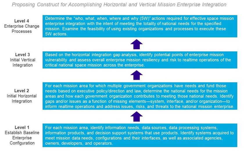
assets, putting both the U.S. and allies into the              existing White House-level entities and connecting
position of relying on an adversary for critical               the results of this enterprise-level collaboration with
weather data.                                                  national space policy.

NOAA’s space-faring organization, the National
                                                               Civil-Military SBEM Ecosystem
Environmental Satellite, Data, and Information
Service (NESDIS), satisfies U.S. domestic                      A Collaborative Effort to Meet the
requirements for space-based environmental                     Nation’s Needs
information through an exquisite suite of                      SBEM systems have provided essential data to
instruments in multiple orbital regimes combined               support military and other national security missions
with data from international partners. NOAA                    for over six decades. Needs span all military
augments its data by ingesting observations from               services with the United States Air Force (USAF)
DOD’s low Earth orbiting (LEO) Defense                         and United States Navy (USN) addressing
Meteorological Satellite Program (DMSP)                        requirements for the Army and Marine Corps,
satellites. In contrast to NOAA’s ability to satisfy its       respectively. USAF historically shouldered the
priority user requirements through a civil                     responsibility to acquire and operate SBEM systems
architecture, DOD depends critically on a robust,              to satisfy joint military needs. In this paper we
joint          military-civil-international     SBEM           reference DOD broadly, mindful that SBEM-related
infrastructure to meet warfighter needs. Both                  responsibilities and authorities will reside within
military and civil SBEM systems are susceptible to             multiple organizational elements across the
adversarial threats as with other non-SBEM space               department.
assets.1, 2, 3 Civil SBEM systems, however, are not
                                                               The core needs of military and civilian SBEM users
subject to equivalent resiliency and asset protection
                                                               are to characterize and forecast the state of the
standards in the face of adversarial threats as are
                                                               natural environment from the seafloor to the sun.
DOD systems. The scope of the U.S. reliance on
                                                               While user priorities diverge across agencies, the
civil systems in the SBEM mission-area to meet
                                                               superset of environmental data needs is shared.
military and other national security requirements
                                                               Table 1 contains a representative sample of
arguably has no equivalent in the space domain.
                                                               environmental parameters collected from space for
Increasing threats to space systems, persistent                military and civilian use. Applications of these data
budget pressures, and the rise of new commercial               include forecasting across all domains (atmosphere,
space business models elevate the mutual benefits              oceans, terrain, space), extreme condition warnings
that could be realized from coordination and                   for safety and infrastructure protection, situational
potential integration of efforts in SBEM across the            awareness products, climate monitoring, and treaty
government. Both NOAA and DOD are at strategic                 compliance monitoring. While a detailed
pivot points with a rare opportunity to collectively           description of why these parameters are relevant to
shape the future as they plan the next-generation              the warfighter is beyond the scope of this paper, we
systems that will operate to 2040 and beyond. This             will describe three examples. Perturbations in the
paper focuses on the opportunity in the context of             solar wind assist with prediction and
the need to assess risk associated with relying on             characterization of geomagnetic storms that can
civil systems to meet military and other national              threaten the health and safety of orbiting DOD
security requirements. It proposes a conceptual                assets. Total electron count is used to monitor
framework to facilitate a whole-of-government                  ionospheric conditions that impact satellite
approach to SBEM collaboration, leveraging                     navigation and communication. Soil moisture is a

                                                           2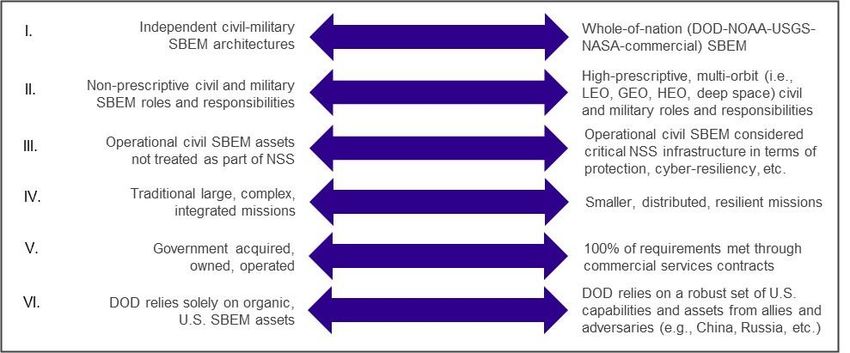
information includes data provided by non-
       Table 1: Common SBEM Needs                                 DOD satellites, such as National Oceanic
                                                                  and Atmospheric Administration (NOAA)
                     Cloud Imagery                                operational weather and NASA research
           Atmospheric Temperature Profiles                       satellites, as well as foreign satellites such as
                                                                  the European and Japanese geostationary
             Atmospheric Moisture Profiles
                                                                  weather satellites.4
                 Vertical Wind Profiles
                                                               A critical subset of civil and military SBEM
              Ocean Surface Vector Winds
                                                               requirements are satisfied through satellites that fly
                      Soil Moisture                            in sun-synchronous polar orbit described in more
                      Snow Depth                               detail below. From the early 1960s until 1994, the
                                                               U.S. operated separate military (i.e., DMSP) and
               Sea Surface Temperature
                                                               civil (i.e., Polar Operational Environmental
                  Total Electron Count                         Satellite, POES) LEO environmental satellite
                       Solar Wind                              programs. In 1994, the White House and Congress
                                                               compelled DOD and NOAA to converge the polar
              Energetic Charged Particles
                                                               programs (i.e., DMSP and POES) into the National
                      Electric Field                           Polar-orbiting Operational Environmental Satellite
Select list of environmental parameter requirements that       System (NPOESS). In February 2010, the U.S.
are shared between civilian and military users.                cancelled NPOESS for overrunning its original cost
                                                               estimates by several billion dollars and subsequently
critical parameter for trafficability forecasts that are       directed DOD and DOC to revert to developing
critical for planning the movement of vehicles and             separate military and civil SBEM systems. In order
troops on the ground.                                          to establish expectations for continued civil-military
                                                               coordination, the White House Office of Science
                                                               and Technology Policy (OSTP) issued policy
Over time, DOD has increasingly relied on civil
                                                               guidance for LEO orbital slot responsibilities
SBEM systems to provide core atmospheric and
                                                               between the agencies as follows: NOAA was
oceanic data. The importance of the SBEM mission
                                                               responsible for the “early afternoon” and “mid-
to the joint warfighter is described in Joint
                                                               morning” orbits. DOD was responsible for the
Publication 3-14, Space Operations:
                                                               “early morning” orbit. The U.S. was to rely on
   Terrestrial    environmental       monitoring               NOAA’s bilateral agreement with the European
   provides information on meteorological and                  Organisation for the Exploitation of Meteorological
   oceanographic (METOC) factors in the                        Satellites (EUMETSAT) to satisfy the “mid-
   maritime, land, and air domains that affect                 morning”       requirement.      The      fundamental
   military       operations.       Space-based                assumption was that each agency would maintain
   environmental sensing supports the                          the continuity of both sounding (i.e., atmospheric
   development of METOC forecasts and                          profiles of temperature and humidity) and imaging
   assessments of environmental impacts on                     capabilities to meet the common civil and military
   both friendly and threat military systems and               needs for environmental data from satellites in all
   operations. Environmental monitoring

                                                           3
three LEO polar orbits.5 These responsibilities were The aforementioned 2010 and 2020 policy
codified in National Space Policy (June 2010): directives are the only existing national policy
documents that explicitly address the relationship
The Secretary of Commerce, through the between DOD and NOAA with respect to SBEM
NOAA Administrator, the Secretary of operations and development. As documented in a
Defense, through the Secretary of the Air U.S. Government Accountability Office (GAO)
Force, and the NASA Administrator shall report to Congress in May 20108, decisions by both
work together and with their international DOD and NOAA were anticipated to clarify
partners to ensure uninterrupted, whether the combined acquisition plans would meet
operational polar-orbiting environmental both civilian and military user requirements. If DOD
satellite observations. The Secretary of decided not to field either imaging or sounding
Defense shall be responsible for the capabilities in the early morning orbit, NOAA
morning orbit, and the Secretary of would need to consider investing in those
Commerce shall be responsible for the capabilities independently. The reverse logic
afternoon orbit. The departments shall applied to DOD for any capabilities NOAA might
continue to partner in developing and choose not to pursue. A May 24, 2021 SpaceNews
fielding a shared ground system, with the article, “A race against time to replace aging
coordinated programs operated by NOAA. military weather satellites,” provides a detailed
Further, the departments shall ensure the accounting of DOD’s pursuit of capabilities to
continued full sharing of data from all replace DMSP.9
systems.6
The updated Space Policy (December 2020)
directed a continuation of the existing (June 2010)
policy regarding LEO orbit responsibilities.7
4The U.S. works with EUMETSAT to fly satellites in three orbits that pass over Earth’s polar
regions and overfly points on Earth at the same local time each day. This is called a Sun-
synchronous polar orbit. Denoted by the local time on the ground of the overpass, the weather
community uses data collected in three such polar orbits commonly referred to as “early
afternoon,” “mid-morning,” and “early morning.” NOAA is responsible for the early afternoon orbit
which crosses the equator at 1330 local time; DOD covers the early morning orbit (0530 local time
equatorial crossing); and EUMETSAT fills the mid-morning orbit (0930 local time) via an
agreement with NOAA. The expectation in national policy for the this three-orbit architecture is
that each agency will maintain the continuity of both sounding (i.e., atmospheric profiles) and
imaging capabilities. This three-orbit architecture provides satellite cloud imagery coverage over
every point on the Earth at least every four hours. Vertical profiles of atmospheric temperature,
moisture, and other parameters from this architecture comprise the core input to weather forecast
models relied upon by both the military and civil communities for weather and oceanic forecasting.
Slight variations in local crossing time are accommodated by the models in practice to allow for
primary and backup satellites in each orbit. The illustration above reflects the current combined
(U.S. and Europe) international SBEM architecture, including NOAA’s JPSS-1 (primary) and
Suomi-NPP (legacy/back-up) systems, EUMETSAT’s Metop, and DOD’s DMSP.
5In the years following the collapse of the NPOESS profiles derived from a remote sensing technique
program, NOAA acquired and fielded capabilities to called Global Navigation Satellite System Radio
replace its legacy POES satellites with the launches Occultation (GNSS RO).13,14 Both NOAA and DOD
of Suomi National Polar-orbiting Partnership are engaged with industry to explore the
(S-NPP) in Fall 2011 and the first Joint Polar opportunities to exploit similar models for other
Satellite System (JPSS-1) in November 2017. SBEM sensor modalities.
Through its agreement with EUMETSAT, who has
launched its series of Metop satellites into the mid- In addition to LEO satellites (such as DMSP, JPSS,
morning orbit, NOAA has met its LEO SBEM and EUMETSAT’s Metop), DOD uses the NOAA
obligations under the 2010 policy. DOD satisfied its Geostationary Operational Environmental Satellite
LEO SBEM obligations while meeting its priority (GOES) systems and similar international systems
warfighter requirements through the launch of under international agreements through NOAA,
DMSP-18 in 2009 and DMSP-19 in 2014. However, such as the Europe’s Meteosat Second Generation
while the cloud imaging instruments continue to (MSG) and Japan’s Himawari satellites. Figure 1
function, DMSP’s atmospheric sounding depicts a recent addition to the DOD family of
capabilities have failed. China is poised to insert systems called EWS-G, which is a repurposed
satellites into nearby orbits and share the data with NOAA GOES satellite that was repositioned over
U.S. allies and adversaries, filling a gap that could the Indian Ocean in April 2020 to support DOD’s
exist for the U.S. and its international partners when U.S. Central Command operations. EWS-G is a
DMSP end-of-life is reached. See the expanded success story of DOD-NOAA SBEM
discussion in the inset box above for a more detailed collaboration.15
description of the structure and rationale for the
SBEM LEO architecture. DOD leveraging of the civil and international
community in space received greater emphasis with
Building on the highly leveraged LEO paradigm, the issuance of the June 2020 Defense Space
DOD’s family of systems concept (Figure 1) Strategy. This strategy provides guidance for
incorporates instruments on platforms in GEO and achieving desired conditions in space over the next
extended orbits to satisfy the full set of warfighter 10 years, including a phased approach for the
and other national security requirements.10 The defense enterprise to move with purpose and speed
family of systems includes two classes of U.S. across three lines of effort:
military, civil, and partner (national and
international) SBEM systems: LEO and GEO Build a comprehensive military advantage in
SBEM systems. DOD and NOAA are also pursuing space
an increasing array of commercial opportunities.11
Shape the strategic environment
New commercial business models (especially for
LEO platforms) may offer viable capabilities at
Cooperate with allies, partners, industry, and
lower cost points to augment or replace government
other U.S. government departments and
owned/operated architectures.12 For example,
agencies16
NOAA has awarded contracts to two commercial
vendors in a data buy model to procure atmospheric
6Figure 1: Current operational view of the SBEM Family of Systems (military, civil, and international) DOD uses to meet
its METOC needs.
7The third element resonates with DOD’s family of through the State Department, to bodies such as the
systems approach to SBEM. However, the extent to Coordination Group for Meteorological Satellites.
which it is pursued carries risk with respect to The U.S. approach is different from other nations,
building a comprehensive military advantage in such as China, who make no practical delineation
space since the allies and partners are primarily civil between military and civil space assets. For the U.S.,
organizations whose operating objectives and the current approach creates a situation where
mandates are generally not related to warfare. As DOD’s SBEM equities are not directly represented
noted throughout this paper, the extent of the in international meteorological satellite forums.
reliance on civil SBEM systems (domestic and
foreign) to meet critical warfighter requirements Domestic and international civil systems are
without a fallback plan, if these systems were to vulnerable to counterspace threats in certain military
become unavailable during conflict, has no direct and geopolitical scenarios. At the same time, NOAA
analog in any other mission area. and allied international SBEM systems are not
mandated to comply with the policies and protocols
National Security Considerations applied to National Security Systems, such as the
DOD reliance on domestic and international civil Committee of National Security Systems Policy
SBEM systems comes with operational risk to No. 1219, that are more stringent than the standards
mission resiliency that must be mitigated or applied to civil systems. This translates to the risk of
accepted. This is not to suggest that reliance on civil disruptions to or degradation/denial of data in
assets is not smart or preferred. Leveraging civil adversarial environments in which civil systems are
systems for military purposes under peace and not designed to operate.20 We are not suggesting that
wartime conditions may represent an optimal cost- the protection standards for civil SBEM be elevated
benefit trade for DOD and the nation. However, to meet standards applied to DOD systems. We do
civil SBEM systems are designed to maintain suggest that the resilience of civil systems under
continuity in nonadversarial operating environments. adversarial operating conditions needs to be
assessed by DOD within the context of their critical
Although the U.S. has benefitted from a stable role in satisfying national security requirements.
SBEM partnership with Europe since the 1980s,
international partnerships generally carry more risk Another security consideration is China’s rise as a
due to factors including local economic conditions primary competitor to the U.S. in the space
and geopolitical dynamics. At any time, other domain.21 China has become active in the SBEM
nations may make decisions reflecting parochial mission area—developing its own meteorological
interests that are not aligned with U.S. priorities. For and oceanic observing satellites and actively
instance, a civil or international partner could seeking partnerships through civil international
commercialize, delay, or cancel acquisition of space Earth observation forums. China launched its first
systems regardless of U.S. impacts. We note that Fengyun series weather satellite in 1988, becoming
partnerships between U.S. agencies are not immune only the third country to do so, and has launched 16
to instability and misalignment of priorities—as Fengyun satellites to date.22 The Fengyun series of
exemplified by the implosion of the Landsat 7 satellites are administered by the Chinese
partnership in the 1990s17 and collapse of NPOESS Meteorological Administration with mission and
in 2010.18 An additional challenge is that DOD must overall capabilities roughly equivalent to DMSP.
rely, as a matter of policy, on NOAA to act as its The Fengyun series appears to be a dual-use asset,
surrogate in international civilian meteorological built to meet the needs of the People’s Liberation
forums. NOAA serves as the U.S. lead, working
8Army Strategic Support Force and broader civil Key questions related to DOD’s continued reliance
needs. on civil systems in the context of the escalating
threats to space systems include:
With the impending end-of-life of the DMSP
satellites, international entities are aware of the gap Does DOD understand the resilience of the civil
in the early morning LEO sounding coverage and SBEM systems upon which it plans to rely in
are considering non-U.S. alternatives. Bolstered by peacetime and under combat conditions?
a request from the World Meteorological
Organization, China is on track to launch imagery, Has DOD assessed the potential benefits of using
sounding, and space weather instruments into the space-based weather data from China and Russia
early morning orbit in 2021.23 On March 15, 2017, (currently allowed by policy) while not realizing
the EUMETSAT Director-General and the China the risk of becoming reliant on space-based
National Space Administration Vice Administrator weather data from those nations (currently
“signed an agreement that provides the policy prohibited by policy) to satisfy warfighter
framework for the continuation and expansion of requirements?
EUMETSAT’s cooperation with China on
monitoring the oceans, atmosphere, and climate How much should DOD depend on civil and
from space.”24 The cooperation includes data commercial SBEM systems to meet critical
exchange, scientific cooperation, and coordination needs ─ especially where the priority for certain
of respective observing systems. The policy space-based observations is not aligned?
framework established by the EUMETSAT
agreement with China “will facilitate the Should DOD consider extending its umbrella of
space asset defense/protection to domestic or
implementation and extensions of the agreements
even foreign civil SBEM assets as alluded to in
already in place between EUMETSAT and the
the recently published USSF Space Power
China Meteorological Administration and the
Doctrine? 27
National Satellite Ocean Application Service.”25
There is a possibility that China will offer the only Should national security resiliency requirements
be applied to NOAA satellites upon which DOD
available early morning sounding data for global
is critically reliant?
weather modeling in the 2024 to 2027 timeframe.
This data has a positive impact on the accuracy of
Given DOD’s reliance on international
civilian and military numerical weather prediction
capabilities in its SBEM family of systems,
models. As such, it is likely this data will find its
should DOD have a greater role in international
way into products used by U.S. civilian and military
forums such as Coordination Group for
forecasters. The FY16 National Defense
Meteorological Satellites?
Authorization Act (NDAA) prohibits DOD reliance
on, but not use of, “space-based weather data Is there a risk that optimal performance of U.S.
provided by the Government of China, the weather prediction models could unintentionally
Government of the Russian Federation, or an entity lead to a reliance on data from China satellites?
owned or controlled by either such government for
national security purposes.”26 NOAA is required to
secure DOC approval for use of data from a Chinese
system.
9Hurdles for DOD’s Pursuit of Next
Generation SBEM Capabilities Table 2: Prioritized DOD MEOTC Needs
DOD’s Priority SBEM Requirements
Following the divergence of NPOESS into separate Priority Joint METOC Needs
DOC and DOD SBEM programs in 2010, USAF 1 Cloud Characterization
initiated the Defense Weather Satellite System
2 Theater Weather Imagery
(DWSS) program to replace DMSP. The DWSS
program was cancelled in 2012 because it was 3 Ocean Surface Vector Winds
considered early-to-need with unsustainable costs.28 4 Ionospheric Density
Subsequently, DOD conducted an analysis of
5 Snow Depth
alternatives to determine updated and prioritized
requirements for DOD SBEM capabilities. In 6 Soil Moisture
September 2014, the analysis of alternatives (AoA) 7 Equatorial Ionospheric Scintillation
results led to a Joint Requirements Oversight
8 Tropical Cyclone Intensity
Council-approved set of 12 high-priority SBEM
requirements29 and a DOD strategy to meet those 9 Sea Ice Characterization
requirements (Table 2). Table 2 entries highlighted 10 Auroral Characterization
in yellow reflect needs that USAF determined
would require a material solution based on the 11 Energetic Charged Particles
finding that civil, commercial satellite weather data, 12 Electric Field
and international partnerships would not sufficiently
Entries in shaded rows reflect needs that DOD
satisfy specific METOC needs, as required by the determined would require a material solution.
FY15 NDAA.30 (Source: JROCM 092-14, September 3, 2014)
DOD-Civil Agency Coordination for SBEM This lack of ongoing, interagency coordination
Mission has led to delays in fielding systems. No one
In the GAO-19-458T report, GAO described three person or organization is held accountable for
DOD challenges relevant to SBEM: growing threats balancing governmentwide needs against wants,
to satellites, implementing leadership changes, and resolving conflicts and ensuring coordination
having the right resources and know-how.31 In the among the many organizations involved with
same report, the GAO reported that past studies and space acquisitions, and ensuring that resources
reviews examining the leadership, organization, and are directed where they are most needed.33
management of national security space found 32:
USSF could address these challenges for all DOD
There is no entity below the president charged to mission areas including SBEM. However, the
integrate SBEM programs across the SBEM mission area encompasses more than a dozen
government. U.S. government and international agencies and
addresses needs that are broader than purely military
Responsibilities for acquiring space systems are interests, which is not within USSF’s charter.
diffused across DOD organizations as well as the Historically, DOD has utilized a variety of
intelligence community and civil agencies, such organizational constructs to provide cross-cutting
as NASA and NOAA, who rely on these SBEM coordination. Some were in place for many
systems. years while others, especially in the past 10 years,
10have been short-lived, leading to inconsistent suggests questions to address in national and DOD
coordination and results. forums, and offers an opportunity to discuss a
potential framework for a whole-of-government
DOD’s organizational structure with respect to the SBEM enterprise integration approach to address
SBEM mission is disaggregated. Congress the GAO concerns:
recognized and attempted to address this challenge
in the 2017 National Defense Authorization Act. In To what extent will future budget pressures
that Act, Congress directed the secretary of defense amplify DOD reliance on civil capabilities to
and the NOAA administrator to jointly establish meet warfighter and other national security
mechanisms to: collaborate and coordinate in needs?
defining roles and responsibilities to carry out
SBEM activities and plan for future What will be the roles of the following DOD
nongovernmental SBEM capabilities.34 In response, offices/organizations in addressing DOD SBEM
DOD and NOAA provided a report to congressional activities, including collaboration with NOAA
subcommittees which included a list of mechanisms and international partners?
used to carry out joint SBEM activities. The
mechanisms included assigning service (USAF and − Space Acquisition Council
USN) deputies to NOAA, joint working groups,
memoranda of agreement, joint participation in − Deputy Assistant Secretary of Defense for
committees, and DOD leveraging NOAA Space Policy
international partners.35 Table 3 provides a snapshot
− Assistant Secretary of the Air Force for
of congressional scrutiny on DOD’s SBEM
Acquisition, Technology & Logistics
portfolio since 2015.
− Assistant Secretary of the Air Force for
A previous structural approach for DOD was to have
Acquisition and Integration
the secretary of the Air Force wear the “hat” of the
principal DOD space advisor (PDSA). The PDSA − Space acquisition organizations including the
staff served as the single SBEM advocate with Space Systems Command and Space
responsibility to coordinate with NOAA on behalf Development Agency
of all DOD equities with a focus on policy and
requirements. For the relatively short amount of − Air Force Weather, Naval Meteorology and
time it existed, this office was effective at promoting Oceanography Command, and other Joint
DOD-NOAA SBEM mission collaboration. In early METOC organizations
2018, the PDSA function was terminated and the
duties, responsibilities, personnel, and resources of Could existing entities that operate within the
the office were transferred to the deputy secretary of U.S. government serve as natural forums to
defense on an interim basis. facilitate whole-of-government, SBEM
planning?
Although DOD and NOAA have the most well-
known operational SBEM needs, other government In the next section, we present a notional framework
organizations have SBEM needs as well (for for six separate dimensions relevant to SBEM
example, NASA, the Intelligence Community, and policy at the department and agency levels.
others). This creates challenges resolving the
problems highlighted by the GAO. However, it also
11Table 3: Congressional Scrutiny on DOD SBEM
Key Document Direction
FY 2015 NDAA, Section 1812 Directs DOD to develop plan for meeting JROC METOC
requirements. Directs GAO to review DOD SBEM analysis
of alternatives (AoA).
GAO Report (GAO-16-252R, March 2016) Recommended that SECDEF ensure the leads of future
SBEM planning efforts establish formal mechanisms for
NOAA collaboration that specify roles and responsibilities.
AF Report to Congressional Committee, August 2016 Delivered DOD plan to meet JROC METOC requirements
through civil and commercial weather data, and
international partnerships.
GAO Report, GAO-16-769T, July 2016 Recommended that DOD establish formal mechanisms for
coordination with NOAA for future SBEM system
acquisitions.
FY 2017 NDAA, Section 1607 Required DOD and NOAA to jointly establish mechanisms
for collaboration and cooperation in SBEM roles and
responsibilities.
AF Report to Congressional Committees, May 2017 Plan to address DOD requirements for cloud
characterization and theater weather imagery.
AF Report to Congressional Committees, Delivered plan for establishing joint mechanisms between
September 2017 NOAA and DOD for defining SBEM roles and
responsibilities.
180-day Congressional Task, Consolidate Directed SECAF to provide a strategy, including proposed
Appropriations Act, 2020 (Public Law 116-93) acquisition plans, estimated cost, and schedule of key
milestones, for an architecture to meet JROC
requirements.
The completion of the DOD SBEM AoA in 2014 spurred over five years of enhanced congressional stakeholder
scrutiny of DOD SBEM acquisition activities. That scrutiny resulted in two NDAAs (FY15 and FY17) addressing
required SBEM actions, three DOD Reports to Congress providing responses to those requirements, three
Government Accounting Office (GAO) reports describing challenges and successes with SBEM system development,
and DOD and NOAA executing a Memorandum of Agreement (MOA) on SBEM Data Collection and Sharing
(Table 2). Over time, DOD and NOAA demonstrated substantial progress on SBEM data collection and sharing
because of this activity. In a 2019 report, the GAO (GAO-19-157SP, March 2019, pg. 13) found that DOD and NOAA
“have made significant progress in establishing and implementing plans to mitigate potential gaps in weather satellite
data.” The agreement between NOAA and DOD to move a repurposed NOAA GOES satellite over the Indian Ocean
for DOD use (EWS-G, described above) is a major success story of that MOA. The resiliency and defense of the civil
assets being utilized by the military and national security community did not appear to factor into the evaluation by
Congress or within the executive branch. In July 2020, Department of Air Force published a report describing its
strategy to address the 12 validated JROC requirements previously prioritized for a material solution. This report
fulfilled the congressional direction in PL 116-93 referenced in the table.
12From Enterprise Integration to Directive-5, Cybersecurity Principles for Space
SBEM Policy Systems.36 While NOAA space systems comply
The SBEM element of the 2010 National Space with civil directives for cyber and other security
Policy was relatively limited in scope and focused measures, they are not held to the more stringent
on LEO assets. The 2020 National Space Policy protection standards applied to other national
expanded top-level guidance to a broader approach security space (NSS) assets. Policy considerations
calling on the secretary of commerce, secretary of include whether civil systems that represent critical
defense, NASA administrator, and heads of other national security infrastructure should benefit from
appropriate agencies to work together to address DOD’s defensive space capabilities, exhibit
next generation space systems planning, ground resilience under adversarial operating conditions,
system architectures for operations, data sharing, and be directed to comply with cyber-protection
international engagement, and commercial data standards equivalent to NSS assets. Closely related
purchases. Figure 2 describes a framework of to resilience is attribute V (Figure 2). Both DOD and
attributes that could address SBEM-related policy NOAA are considering disaggregated architectures
from a whole-of-government perspective and for select missions, where it makes sense, which is
facilitate assessment of risks associated with the inherently associated with increased resilience. The
reliance on civil systems to meet NSS requirements. final element of the framework involves defining
The six attributes include: (I) Nature of the nation’s U.S. objectives with respect to international SBEM
SBEM architecture ranging from independent civil partnerships (attribute VI, Figure 2).
and military constellations to an interdependent,
whole-of-nation approach; (II) Scope with respect to In summary, the proposed policy framework
the division of roles and responsibilities between establishes attributes to address in a robust SBEM
NOAA and DOD ranging from a broad, policy dialogue. We anticipate that these policy
nonprescriptive to highly prescriptive policy that questions could be informed by outcomes of a
defines roles and responsibilities for NOAA and multiagency coordination process described in the
DOD across all orbital regimes (LEO, GEO, etc.); next section of the paper. The attributes in Figure 2
(III) Treatment of operational civil SBEM assets as are illustrated as a sliding scale with the left and
critical NSS infrastructure (or not) including right positions considered to be extreme, opposite
consideration of cyber-resiliency and other factors; positions. They are sufficiently independent to
(IV) Architecture characteristics ranging from envelop the needed policy dimensions but are not
traditional, large, complex integrated missions to necessarily mutually exclusive. Note that this paper
smaller, distributed, resilient missions; (V) Pursuit neither characterizes the current state with respect to
of commercial services; and (VI) The extent of each attribute nor advocates for the future direction
DOD reliance on data from friendly and unfriendly of agency- and national-level policy. The intent is to
international sources versus a purely organic, U.S. outline the spectrum of options. In the context of this
assets. framework, discussions focused on the key
questions posed throughout the paper would help
Many of these attributes are actively being inform the revision of national civil space policy and
discussed today across the government. The cyber its flow down into future DOD and NOAA (and
resiliency of space-based assets (attribute III) is the other) SBEM plans.
topic of the recently released Space Policy
13Figure 2: Proposed framework of policy attributes to consider at the national and DOD levels. Note that “whole-of-
nation” is whole-of-government + commercial + academia.
A Conceptual Framework for Whole-of- and distributed computing environments.37 It is also
Government SBEM Integration a concept in enterprise engineering focused on
Policy guidance at the White House, department enabling communication between people
level, and agency level addressing the dimensions (organizations), machines, and computers and their
described in Figure 2 can be informed by and set the efficient cooperation and coordination.38 For this
stage for whole-of-government SBEM coordination discussion, we adopt the concept of enterprise
or integration. However, the independence of U.S. integration as a structured process, or framework
government agencies with respect to mission (Figure 3) to coordinate across U.S. government
essential functions, statutory responsibilities, stakeholders with an objective to field and sustain a
budget, executive direction, process-driven system of SBEM systems to deliver critical national
timelines, and congressional oversight does not benefits. We describe and apply the framework not
naturally facilitate integrated, whole-of-government to suggest it is the solution for the nation, but as an
programming, planning, and execution. The SBEM illustration of how integration could be achieved
mission-area nevertheless presents a compelling within the existing interagency construct for the
business case for multiagency planning on a grand SBEM mission area. The utility of the framework is
scale. In order to advance the SBEM dialogue, a not narrowly limited to the SBEM mission area.
conceptual framework for whole-of-government
coordination/integration is described. Here we The integration framework (Figure 3) has four
define an enterprise as all organizations (e.g., levels. Level 1 begins with analysis by individual
government, commercial, academic, and SBEM mission organizations performing a normal
international) contributing to common activities. cyclical review of mission needs (current and
developing), assessing current capabilities to meet
those needs, identifying gaps, prioritizing those
At a top level, enterprise integration is a technical gaps, and developing mission architecture
field of enterprise architecture that addresses plans/changes to address gaps. Each SBEM
challenges such as system interconnection, organization performs this review based on needs
electronic data interchange, product data exchange,
14from multiple sources—some specifically given to enterprise gaps in SBEM-related capabilities in the
an organization based on its mission and stated in full context of national SBEM needs. Level 3
executive direction or law (e.g., NDAA for DOD vertically integrates the Level 2-identified gaps,
SBEM mission), and others that may be part of a evaluates them for potential SBEM vulnerabilities,
national plan or strategy (e.g., National Space and assesses enterprise SBEM resiliency and risks.
Weather Strategy, 2019 National Plan for Civil Level 4 of the framework determines the viability
Earth Observations, FY22 White House Office of and path of SBEM enterprise change processes.
Management and Budget/OSTP Research and
Development Priorities, etc.). Framework levels 2, A key question is: where within the structure of the
3, and 4 are performed collaboratively by the entities government can the Level 2 through 4 coordination
that participated in the Level 1 analysis. occur? There are two White House-level bodies
whose charters might be extended to at least
Level 2 addresses horizontal integration of inputs facilitate a dialogue. United States Group on Earth
across the multiple SBEM organizations— Observations (USGEO) and Interagency Council
comparing the total capabilities of all SBEM for Advancing Meteorological Services (ICAMS)
organizations against “whole-of-government” needs are White House-level bodies chartered to perform
in observational capability, data and information, aspects of SBEM-related enterprise integration (see
and/or services. The anticipated result is a list of appendix). Their charters do not explicitly
Figure 3: Notional space mission enterprise integration framework.
15charge USGEO or ICAMS to facilitate SBEM might not satisfy national security resilience
integration at a system of systems architectural level requirements under adversarial operating
across the U.S. government. However, these conditions. Challenges for the U.S. in the SBEM
organizations could facilitate discussions to catalyze mission-area are not limited to resilience. China’s
an integration effort. muscular initiatives in the SBEM mission-area
threaten U.S. preeminence and introduce the risk of
With a formalized conceptual approach to achieving future reliance by global weather centers for
integrated outcomes, the U.S. could move toward a operational forecast modeling on potentially high-
robust, whole-of-government approach to SBEM. quality data from an adversary.
Potential outcomes include decadal strategic plans
for enhancing SBEM, strengthened partnerships Stakeholders in the SBEM mission-area span at
with nongovernment sectors and international least 18 U.S. government entities. In order to
partners, and coordinated interagency messaging to illuminate opportunities for multi-agency
inform senior policymakers of SBEM capability integration, this paper presents a conceptual
needs, vulnerabilities, and resiliency. Another approach to enterprise SBEM integration and
objective could be refined strategic messaging of connects it to a robust set of enabling national and
SBEM benefits related to national and economic agency-level policy attributes. Macro-level choices
security as well as societal factors such as public range from independence between the space-faring
safety. SBEM enterprise integration across the U.S. agencies, with expectation to create and capitalize
government must be enabled by national and on leveraging opportunities, to full scale joint
agency-level policy. mission planning based on a whole-of-nation
strategy. Across the broader U.S. enterprise,
Conclusions existing entities within the government (i.e.,
USGEO and ICAMS) could be utilized to advance
The combined space-based capabilities of NOAA
the nation toward an enterprise approach to SBEM
and DOD represent critical national security
to address needs ranging from operational
infrastructure. NOAA satisfies its priority
forecasting to long-term climate monitoring. The
requirements through a civil space architecture
results of such an integrated approach hold the
while DOD relies on a joint military-civil satellite
promise of addressing national security imperatives,
ecosystem to satisfy warfighter requirements. The
NOAA’s primary mission essential functions, and
use of civil satellites is not unique to the SBEM
the broad needs of the nation for decades to come.
mission-area. However, the scope of DOD’s
reliance on a civil-military-international family of
systems for SBEM exceeds any other mission area. Acknowledgments
NOAA and DOD sit at pivot points with an The authors would like to express their gratitude to
opportunity to plan the next generation of Rebecca Reesman, Michael Van Woert, John
environmental satellites that will comprise the Maguire, Jamie Morin, Martin Whelan, Robert
combined U.S. architecture out to 2040 and beyond. Winokur, Donald Boucher, Jennifer Clapp, LeRoy
Collins, John Haas, Richard Heidner, Orlando
Given DOD’s dependence on non-military assets, it Figueroa, and Charles Wooldridge for their helpful
is important to assess the national security risks reviews and comments.
associated with reliance on civil SBEM assets that
16Appendix – SBEM, A Whole-of- Geological Survey (USGS) has continuously
Government Mission Area operated Landsat satellites since 1972. These
satellites acquire space-based images of the Earth’s
land surface, providing uninterrupted data to help
land managers and policymakers make informed
decisions about our natural resources and the
environment. Landsat data informs good decisions
in many disciplines, especially human health,
agriculture, climate, energy, fire, natural disasters,
urban growth, water management, ecosystems and
biodiversity, and forest management.43 Currently,
USGS and NASA are teaming up to build the next
Although this paper focuses on DOD, NOAA and
Landsat mission, Landsat 9, which is scheduled for
NASA SBEM opportunities and challenges, other
launch in mid-2021. EPA scientists are
federal agencies rely heavily on DOD and NOAA
collaborating with NASA, the Smithsonian
SBEM data and augment that support with their own
Astrophysical Observatory (SAO) and NOAA on a
operations or research and development in SBEM
project that will use satellites to examine air quality
technology. This makes SBEM very much a whole-
across North America. The Tropospheric Emissions
of-government mission. Across all agencies, the
Monitoring of Pollution (TEMPO) satellite, part of
federal government invests more than $3 billion in
NASA’s Earth Venture Instrument program, is
civil Earth observations and data to ensure national
scheduled for launch in 2022 to monitor air quality
security, enhance public safety and infrastructure
during the daylight hours in geostationary orbit. 44
protection, promote quality of life, strengthen the
economy, and fulfill other agency missions.39 Two interagency organizations work from a whole-
of-government perspective across the environmental
Other federal agencies that prominently figure into enterprise including SBEM to achieve a level of
the whole-of-government SBEM equation (i.e., what we refer to as enterprise integration. They are
SBEM “enterprise”) include the Department of The United States Group on Earth Observations
Agriculture (USDA), Department of Energy (DOE), (USGEO) and the Interagency Council for
Department of Homeland Security (DHS), Advancing Meteorological Services (ICAMS).
Department of Interior (DOI), and Environmental
Protection Agency (EPA). USDA works closely USGEO is a chartered subcommittee of the National
with NOAA and NASA to field integrated Science and Technology Council (NSTC)
capabilities to identify fires and to forecast fire Committee on Environment.45 USGEO’s purpose is
weather conditions.40 DOE collaborates with NASA to plan, and coordinate federal Earth observations,
to monitor atmospheric radiation and to collect data research, and activities; foster improved Earth
to support decisionmaking and policymaking system data management and interoperability;
related to space nuclear power and propulsion, space identify high priority user needs for Earth
situational awareness, space weather, and climate observations data; and engage international
change.41 Teaming with DOD, DHS’s recent SBEM stakeholders by formulating the United States’
initiative, called Polar Scout, supports the U.S. position for, and coordinating U.S. participation in,
Coast Guard’s (USCG) mission to ensure safe, the intergovernmental Group on Earth Observations
secure, and environmentally responsible maritime (GEO). USGEO has 15 members, including:
activity in U.S. Arctic waters.42 The DOI’s U.S.
17 Five departments (Agriculture, Defense, Energy, required OSTP to form such an interagency
State, and Transportation) committee.46 Under the charter, ICAMS will lead
the annual development of an interagency budget
Eight agencies (Environmental Protection review of programs supporting meteorological
Agency (EPA), NASA, National Institutes of services and supporting research and annual
Health (NIH), National Institute of Standards implementation plans. DOD will participate to the
and Technology (NIST), NOAA, NSF, limits imposed by the Federal Acquisition
Smithsonian Institution, and U.S. Geological Regulations. ICAMS is a multi-agency Executive
Survey (USGS) Branch activity, served by an administrative
organization (Interagency Meteorological
Two organizations within the Executive Office Coordination Office—IMCO) and four
of the President, the Office of Management and subcommittees focusing on observational systems;
Budget (OMB) and Office of Science and cyber, facilities and infrastructure; services; and
Technology Policy (OSTP) research and innovation.
Although the focus of USGEO is on civil Earth The ICAMS co-chairs are the OSTP Director and
observations, DOD has been active in USGEO since the Undersecretary of Commerce for Oceans and
its formation in 2003. USGEO takes an enterprise Atmospheres (NOAA Administrator). ICAMS
approach to its activities, defining the Earth members include the Executive Office of the
Observations Enterprise as the multi-sector President (OMB and OSTP), nine departments
enterprise consisting of federal agencies; state, (Agriculture, Commerce, Defense, Energy, Health
local, tribal, and territorial governments; world- and Human Services, Homeland Security, Interior,
leading colleges and universities; private industries; State, and Transportation), and five agencies (EPA,
non-profit organizations; and federal and national NASA, Nuclear Regulatory Commission, NSF, and
laboratories. USGEO works to achieve its purposes National Transportation and Safety Board).
through coordination of the acquisition, analysis, ICAMS’ main goal is for the “United States to lead
dissemination, and use of Earth observations; the the world in meteorological services via an Earth
operation of enabling infrastructure; sustaining and system approach, providing societal benefits with
advancing the creation of data and information information spanning local weather to global
products; maintaining routine uses; and developing climate.” The charter is specific in stating that
innovative applications for societal, environmental, ICAMS does not represent budget authorities, does
and economic progress. Lastly, USGEO uses its not imply any resource commitments by member
enterprise approach to open opportunities for agencies, and does not make policy. However,
partnerships for the provisioning and analysis of ICAMS can inform policy, coordinate for relevant
Earth observations. Over the course of its 17 years policies and practices across agencies, and foster
of existence, USGEO has represented a coalition of engagement with other federal coordination
the willing focused on the data and information organizations, such as the NSTC to meet the goals
resulting from observation systems, including articulated by the council.
satellites.
ICAMS was chartered on July 31, 2020, having
been formed as a result of the 2017 Weather
Research and Forecasting Innovation Act (Public
Law 115-25, Title IV, sec 402, 15 USC) which
18References
1
“Challenges to Security in Space,” Defense commercial-ro-contracts-supporting-operational-
Intelligence Agency, 2019 (www.mil/Military-Power- weather-forecasting/).
Publications). 14
“Global Navigation Satellite System Radio
2
“National Security Space Defense and Protection,” Occultation (GNSS-RO),” University Corporation for
The National Academies Press, 2018 Atmospheric Research (UCAR) Community
(https://www.nap.edu/catalog/23594/national- Programs, Constellation Observing System for
security-space-defense-and-protection-public-report). Meteorology, Ionosphere and Climate (COSMIC),
3
“Worldwide Threat Assessment of the US May 20, 2021 (https://www.cosmic.ucar.edu/what-
Intelligence Community,” Director of National we-do/gnss-radio-occultation/).
Intelligence (DNI), 13 Feb 2018. 15
Werner, D., “Air Force Turns to Partners for Weather
4
“Space Operations,” Joint Publication 3-14, para 7a., Forecasting Support,” SpaceNews, January 13, 2020
10 April 2018. (https://spacenews.com/air-force-ams-2020/).
5 16
Congressional Hearing on Polar Weather Satellites Defense Space Strategy Summary, U.S. Department
(House Science and Technology Committee), June of Defense, June 2020, p 1.
17
29, 2010 Assessment of Impediments to Interagency
(https://www.govinfo.gov/content/pkg/CHRG- Collaboration on Space and Earth Science Missions,
111hhrg57600/pdf/CHRG-111hhrg57600.pdf). 2011
6
National Space Policy of the United States of (https://www.nap.edu/catalog/13042/assessment-of-
American, June 28, 2010, p. 12. impediments-to-interagency-collaboration-on-space-
7
National Space Policy of the United States of and-earth-science-missions).
18
America, December 9, 2020, p. 25. Restructuring the National Polar-orbiting Operational
8
“Polar-Orbiting Environmental Satellites: Agencies Satellite System (White House Fact Sheet), 2010
Must Act Quickly to Address Risks That Jeopardize (https://obamawhitehouse.archives.gov/sites/default/fi
the Continuity of Weather and Climate Data.” les/npoess_decision_fact_sheet_2-1-10.pdf).
19
Government Accounting Office, GAO-10-558, May National Security Systems such as the Committee of
2010, p. 20 National Security Systems Policy (CNSSP) No. 12
(https://www.gao.gov/assets/310/304904.pdf). (https://www.cnss.gov/CNSS/issuances/Policies.cfm).
9
Erwin, S. and Berger, B., “A race against time to 20
“Department of Defense Plan to Meet Joint
replace aging military weather satellites,” SpaceNews, Requirements Oversight Council Meteorological and
May 24, 2021 (https://spacenews.com/a-race-against- Oceanographic Collection Requirements,” United
time-to-replace-aging-military-weather-satellites/). States Air Force Report to Congressional
10
“Department of Defense Plan to Meet Joint Committees, August 2016.
21
Requirements Oversight Council Meteorological and Stokes, M., Alvarado, G., Weinstein, E., and Easton,
Oceanographic Collection Requirements,” United I., “China’s Space and Counterspace Capabilities and
States Air Force Report to Congressional Activities,” Project 2049 Institute, March 30, 2020,
Committees, August 2016, p. 11. p. 8.
11 22
Office of Space Commerce, News on NOAA Ibid, p. 36.
23
Commercial Space Solutions, September 1, 2020 World Meteorological Organization, Observing
(https://www.space.commerce.gov/category/governm System Capability Analysis and Review Tool, 9
ent-business/noaa-commercial-space-solutions/). October 2020 (https://www.wmo-
12
Morin, J., and Wilson, R.S., “Leveraging Commercial sat.info/oscar/satellites).
Space for National Security,” Space Agenda 2021, 24
European Organisation for the Exploitation of
Center for Space Policy and Strategy, November Meteorological Satellites (EUMETSAT),
2020, p. 2 “EUMETSAT and China National Space
(https://aerospace.org/sites/default/files/2020- Administration Sign Framework Agreement,” March
11/Morin-Wilson_Leveraging_20201113.pdf). 15, 2017 (https://www.eumetsat.int/eumetsat-and-
13
“NOAA Awards First Commercial RO Contracts china-national-space-administration-sign-framework-
Supporting Operational Weather Forecasting,” Office agreement).
25
of Space Commerce, National Oceanic and Ibid.
26
Atmospheric Administration, November 20, 2020 PL 114-92, Sec 1614.
(https://www.space.commerce.gov/noaa-awards-first-
1927 Manufacturing: The 21st Century Competitive
Space Capstone Publication, Spacepower Doctrine
for Space Forces United States Space Force, Aug Strategy, Elsevier, 2001, pages 461-481.
39
2020, p. 35 U.S. Group on Earth Observations, Office of Science
(https://www.spaceforce.mil/Portals/1/Space%20Cap and Technology Policy, The White House (President
stone%20Publication_10%20Aug%202020.pdf). Barack Obama) Archives.
28
“Defense Weather Satellites: DOD Faces Acquisition (https://obamawhitehouse.archives.gov/administratio
Challenges for Addressing Capability Needs,” n/eop/ostp/nstc/committees/cenrs/usgeo).
Government Accounting Office, GAO-16-769T, 7 40
“Tracking Damage and Air Quality Impacts from
July 2016, p. 3. Fires,” NASA Earth Science Applied Sciences
29
“Department of Defense Plan to Meet Joint (https://disasters.nasa.gov/fires).
Requirements Oversight Council Meteorological and 41
“Energy for Space: Department of Energy’s Strategy
Oceanographic Collection Requirements,” United to Advance American Space Leadership,”
States Air Force Report to Congressional Department of Energy
Committees, August 2016, p. 4. (https://www.energy.gov/sites/prod/files/2021/01/f82/
30
Ibid, Section 1612, pp. 4-9. Energy%20for%20Space-
31
“Space Acquisitions: DOD Faces Significant DOE%20Space%20Strategy%20Paper%2001-06-
Challenges as it Seeks to Accelerate Space Programs 2021.pdf).
and Address Threats.” Government Accounting 42
Schrieber, M., “U.S. Coast Guard Satellites Ceased
Office, GAO-19-458T, 27 March 2019. Communicating Soon After Launch,” Arctic Today,
32 June 19, 2019 (https://www.arctictoday.com/us-coast-
Ibid.
33
Ibid. guard-satellites-ceased-communicating-soon-after-
34
National Defense Authorization Act of 2017, Section launch/).
1607. 43
“How Landsat Helps Us,” NASA Landsat Science
35
“Joint Mechanisms for Defining the Space-based (https://landsat.gsfc.nasa.gov/how-landsat-helps).
Environmental Monitoring Roles and Responsibilities 44
“TEMPO: A New Era of Air Quality Monitoring
of the Department of Defense and the National from Space,” U.S. Environmental Protection Agency
Oceanic and Atmospheric Administration,” United (https://www.epa.gov/sciencematters/tempo-new-era-
States Air Force Report to Congressional air-quality-monitoring-space).
45
Committees, August 2017, p. 7. U.S. Group on Earth Observations, Office of Science
36 and Technology Policy, The White House (President
Memorandum on Space Policy Directive-5,
Cybersecurity Principles for Space Systems, Barack Obama) Archives
September 4, 2020 (https://obamawhitehouse.archives.gov/administratio
(https://www.whitehouse.gov/presidential- n/eop/ostp/nstc/committees/cenrs/usgeo).
46
actions/memorandum-space-policy-directive-5- Interagency Council on Advancing Meteorological
cybersecurity-principles-space-systems/). Services (ICAMS), Frequently Asked Questions
37 (FAQs), October 23, 2020
Vernadat, F., Enterprise Modeling and Integration:
Principles and Applications, Chapman & Hall, (https://www.ofcm.gov/publications/icams_faqs_publ
London 1996. ic_102320.pdf).
38
Vernadat, F., “Enterprise Integration and
Management in Agile Organizations,” Agile
20You can also read