International Journal of Advance Engineering and Research
←
→
Page content transcription
If your browser does not render page correctly, please read the page content below
e-ISSN (O): 2348-4470
                  Scientific Journal of Impact Factor (SJIF): 5.71
                                                                                        p-ISSN (P): 2348-6406

                   International Journal of Advance Engineering and Research
                                       Development
                                        Volume 5, Issue 03, March -2018

      Tropical cyclone Phailin Track Simulation using the advanced mesoscale
                 Weather Research and Forecasting (WRF) model
                                        P. Janardhan Saikumar1, Dr. T. Ramashri 2
             1
                 Research Scholar, Department of ECE, SVUCE, S V University, Tirupati, A.P. -517502, India
                   2
                     Professor, Department of ECE, SVUCE, S V University, Tirupati, A.P. -517502, India

Abstract- The Severe Cyclonic Storm Phailin caused extensive damage and loss of life in Odissa, India, during October
2013. The cyclone developed from a low pressure system that formed under the influence of an upper-air cyclonic
circulation in the Andaman Sea and intensified into a Severe Cyclonic Storm and crossed Odisha coast near Gopalpur
on 12 October, 2013. High surge (~2.3m) generated by the cyclone washed away some of the coastal structures
constructed at the Gopalpur port besides causing coastal erosion. Wind damage was quite extensive around 50km radius
of the cyclone track. The model domain consists of one coarse and two nested domains. The resolution of the coarse
domain is 45 km while the two nested domains have resolutions of 15 and 5 km, respectively. The results from the inner
most domain have been considered for analyzing and comparing the results. Model simulation outputs are compared
with corresponding observation data. The model was run for 72 hrs starting from 10 October, 2013 to 13 October 2013.
The track and intensity of simulated cyclone are compared with best track estimates provided by the Joint Typhoon
Warning Centre (JTWC) data. Simulations are performed using four convective cumulus parameterization schemes,
namely, BMJ (Betts-Miller-Janjic), GD (Grell-Devenyi), G3D (improved Grell-Denenyi) and KF (Kain-Fritsch) in
combination with different microphysics parameterization schemes, namely, Kessler Scheme, Lin et al. Scheme, WSM-3
scheme, WSM-5 scheme and Thompson Schemes. The main purpose of the present study is to find the best suitable
combination of microphysics, cumulus and PBL schemes for the simulation of accurate track of severe tropical cyclones
over Bay of Bengal. The cumulus, planetary boundary layer (PBL) and microphysics (MP) parameterization schemes
have more impact on the track and intensity prediction skill than the other parameterizations employed in the mesoscale
model.
Keywords- Phailin, WRF Model, physics parameterizations, Cyclone track, Track error

                                               I.    INTRODUCTION

The Severe Cyclonic Storm Phailin was the most intense tropical cyclone to make landfall in India. The system was first
noticed as a tropical depression on October 4, 2013 within the Gulf of Thailand. Over the next few days, it moved
westwards within an area of low to moderate vertical wind shear, before as it passed over the Malay Peninsula, it moved
out of the Western Pacific Basin on October 6 and moved into the Andaman Sea during the next day and moved west-
northwest into an improving environment for further development before the system was named Phailin on October 9,
after it had developed into a cyclonic storm and passed over the Andaman and Nicobar Islands into the Bay of Bengal.
On October 10, Phailin intensified rapidly and became a very severe cyclonic storm, equivalent to a category 1 hurricane
on the Saffir-Simpson hurricane wind scale (SSHWS). On October 11, the system became equivalent to a category 5
hurricane on the SSHWS before it started to weaken during the next day as it approached the Indian state Odisha. It made
landfall later that day, near Gopalpur in Odisha coast at around 2130 IST (1600 UTC). It subsequently weakened over
land as a result of frictional forces. The numerical weather prediction and dynamical models provides good guidance
with respect to cyclone genesis, track and intensity. The India Meteorological Department (IMD) and the Joint Typhoon
Warning Centre (JTWC), USA predicted the genesis, intensity, track, point and time of landfall 5 days in advance. The
synoptic features of cyclone phailin was studied with different microphysics schemes using Advanced Research Weather
Research and Forecasting (ARW-WRF, hereafter WRF) mesoscale model developed at National Center for Atmospheric
Research (NCAR) because of its superior performance in generating fine-scale atmospheric structures as well as its better
forecast skill (Otkin et al. 2005; Pattanayak and Mohanty 2008).

                                       II.    DATA AND METHODOLOGY

Numerical Weather Prediction (NWP) model used in cyclone simulation is the Advanced Research WRF (ARW) v 3.6.1
mesoscale model developed by NCAR. NWP is a method of weather forecasting that uses governing equations, different
numerical methods, parameterization schemes, different domains and Initial and boundary conditions. The MODIS based
terrain topographical data have been used for domain1, domain2 and domain3 in the WRF Preprocessing system (WPS).

@IJAERD-2018, All rights Reserved                                                                              404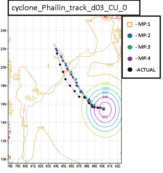
International Journal of Advance Engineering and Research Development (IJAERD)
                    Volume 5, Issue 03, March-2018, e-ISSN: 2348 - 4470, print-ISSN: 2348-6406

                              Figure 1. WPS domain configuration used in simulation

The Initial and boundary conditions are obtained from the UCAR & NCAR Research Data Archive
http://rda.ucar.edu/datasets/ds083.2/index.html#sfol-wl-/data/ds083.2?g=2. These NCEP FNL (Final) Operational Global
Analysis data are on 1-degree by 1-degree grids prepared operationally every six hours. For all the three TC simulations
the model output is generated for every six hours were taken into consideration for track position.

                                Table 1. List of MP and CP used in WRF simulations

                                 Model Microphysics(mp) parameterization schemes

                   1                    Kessler scheme (mp option=1)                            KS
                   2                   Lin et al. scheme (mp option=2)                         LIN
                   3      WRF Single Moment 3-class simple ice scheme(mp option=3)            WSM3
                   4          WRF Single Moment 5-class scheme (mp option=4)                  WSM5
                   5      Thompson graupel scheme 2 moment (mp option=8)                      THOM2

                               Model Cumulus-physics (cp) parameterization schemes

                   1      Kain-Fritsch(new Eta) scheme (cu Option=1)                             KF
                   2                 Betts-Miller-Janjic scheme (cu Option=2)                   BMJ
                   3      Grell-Devenyi ensemble scheme (cu option=3)                           GD
                   4                 Grell-3D ensemble scheme (cu option=5)                     G3D
                                         Planetary Boundary Layer (PBL)
                   1      Yonsei University Scheme (bl_pbl Option=1)                            YSU

The WPS domain configuration is generated using NCL (NCAR Command Language). The CP and MP parameterization
schemes used in the present simulation to investigate the track of the tropical cyclones were listed in Table-1 and WRF
Model dynamics and domain details are listed in Table.2

@IJAERD-2018, All rights Reserved                                                                             405
International Journal of Advance Engineering and Research Development (IJAERD)
                    Volume 5, Issue 03, March-2018, e-ISSN: 2348 - 4470, print-ISSN: 2348-6406

                                     Table 2. WRF Model dynamics and domain details

                                                   WRF Model Dynamics
                  Equation                                        Non-hydrostatic
           Time integration scheme                        Third-order Runge-Kutta scheme
             Horizontal grid type                                 Arakawa-C grid
                                                  WRF Model Domain details
               Map projection                                   Mercator projection
              Central point of the                                  75oE, 20oN
                   domain
               No. of domains                                                 3
            No. of vertical layers                                           27
           Horizontal grid distance                45 km , 15 km & 5 km for domain 1, 2 & 3 respectively
                 Time step                        180 sec, 30 sec & 10 sec for domain 1, 2 &3 respectively
             No. of grid points                               173 (EW), 148 (SN) in domain 1
                                                              253 (EW), 295 (SN) in domain 2
                                                              310 (EW), 355 (SN) in domain 3

                                           III.    RESULTS AND DISCUSSIONS

The Simulations for the Phailin cyclone were carried out in order to determine the best MP adn CP parameterization
scheme for track prediction. Results from domain-3, have been used for the analysis. In all the simulations Yonsei-
University (YSU) planetary boundary layer (PBL) scheme is kept fixed.
The simulated track of Phailin cyclone with different MP and CP parameterization schemes are plotted in the Figure 3.
The simulated track of Laila cyclone with different MP and CP parameterization schemes are plotted in the Figure 4.
 Grid Analysis and Display System (GrADS) was used for visualization of the wrf output.
The wrf model output and the JTWC observed track were compared concurrently. Track error is calculated using Haver-
Sine formula. The track error for Phailin TC for different CP and MP is plotted in Figure 5.

                                     (4)

Where D is Track error, φ is latitude, λ is longitude, R is earth’s radius (mean radius = 6,371km) and the angles are in
radians.

                                           IV.      PHAILIN SIMULATIONS

Phailin TC Simulations were initiated on 8th October 2014, 0000 UTC with lateral boundary condition and were carried
up to 13 October 2014, 1200 UTC. The model was run up to 132hr and the simulated track of the Phailin cyclone with

@IJAERD-2018, All rights Reserved                                                                             406
International Journal of Advance Engineering and Research Development (IJAERD)
Volume 5, Issue 03, March-2018, e-ISSN: 2348 - 4470, print-ISSN: 2348-6406
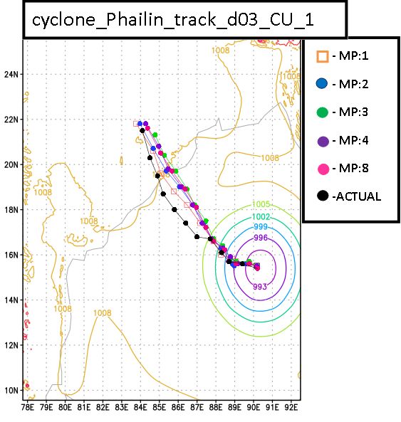
different MP schemes and no CP parameterization scheme (cu=0) are plotted in the Figure 2. The Phailin cyclone with
different MP schemes and Kain-Fritsch (new Eta) CP parameterization scheme (cu=1) are plotted in the Figure 3.
Figure 2. Phailin track simulations with different MP schemes and without CP scheme (cu=0)
Figure 3. Phailin track simulations with different MP schemes and fixed Kain-Fritsch(new Eta) scheme CP (cu=1))
@IJAERD-2018, All rights Reserved 407International Journal of Advance Engineering and Research Development (IJAERD)
Volume 5, Issue 03, March-2018, e-ISSN: 2348 - 4470, print-ISSN: 2348-6406
The track error of Phailin TC simulations for different mp schemes and cp parameterization scheme are plotted in the
Figure 4.
Figure 4. Track error of Phailin TC simulations
Time variation of model simulated central sea level pressure (CSLP) with JTWC observations for Phailin TC in hPa is
plotted in Figure 5.
Figure 5. Time variation of model CSLP with JTWC in (hPa)
V. CONCLUSIONS
In this paper, Phailin cyclone is simulated over the coast of Bay of Bengal and presented the best possible
combination of microphysics and cumulus physics. For Phailin TC simulations Kessler scheme (mp option=1)
microphysics scheme in combination Kain-Fritsch (new Eta) scheme (cu Option=1) cumulus scheme gives out the
best results which closely matches with the JTWC track. The track error for this combination is minimum of all the
other combinations.
ACKNOWLEDGEMENT
We express our sincere thanks to the Centre of Excellence, "Atmospheric remote sensing and Advanced Signal
Processing", Department of ECE, Sri Venkateswara University College of Engineering, Sri Venkateswara University,
Tirupati, for providing necessary resources to carry out the present work.
@IJAERD-2018, All rights Reserved 408International Journal of Advance Engineering and Research Development (IJAERD)
Volume 5, Issue 03, March-2018, e-ISSN: 2348 - 4470, print-ISSN: 2348-6406
REFERENCES
[1] Gray, W. M., (1968): Global view of the origin of tropical disturbances and storms. Mon. Wea. Rev., 96, 669-700.
[2] Biranchi Kumar Mahalaa, Pratap Kumar Mohanty, Birendra Kumar Nayak ," Impact of Microphysics Schemes in
the Simulation of Cyclone Phailin using WRF model", 8th International Conference on Asian and Pacific Coasts
(APAC 2015)
[3] R Chandrasekar and C Balaji, " Sensitivity of tropical cyclone Jal simulations to physics parameterizations", J.
Earth Syst. Sci. 121, No. 4, August 2012, pp. 923–946
[4] Report on cyclonic disturbances over north Indian Ocean during 2014
[5] Deshpande M, Pattnaik S and Salvekar P 2010 Impact of physical parameterization schemes on numerical
simulation of super cyclone Gonu; Natural Hazards 55(2) 211–231.
[6] Pattnaik S and Krishnamurti T 2007 Impact of cloud microphysical processes on hurricane intensity. Part 2:
Sensitivity experiments; Meteorol. Atmos. Phys. 97(1) 127–147.
[7] Rao D and Prasad D 2007 Sensitivity of tropical cyclone intensification to boundary layer and convective
processes; Natural Hazards 41(3) 429–445.
[8] Osuri, K.K., Mohanty, U.C., Routray, A., Kulkarni, M.A., Mohapatra, M., 2012. Customization of WRF-ARW
model with physical parameterization schemes for the simulation of tropical cyclones over North Indian Ocean.
Natural Hazards 63:1337–1359.
[9] Srinivas C, Venkatesan R, Bhaskar Rao D and Hari Prasad D 2007 Numerical simulation of Andhra severe
cyclone (2003): Model sensitivity to the boundary layer and convection parameterization; Pure Appl. Geophys.
164(8–9) 1465–1487.
[10] Srinivas, C.V., Rao, D.V.B., Yesubabu, V., Baskarana, R. and Venkatraman, B. (2013) Tropical Cyclone Predictions
over the Bay of Bengal Using the High-Resolution Advanced Research Weather Research and Forecasting (ARW)
Model. Quarterly Journal of the Royal Meteorological Society, 139, 1810-1825.
[11] Raju, P.V.S., Potty, J. and Mohanty, U.C. (2011) Sensitivity of Physical Parameterizations on the Prediction of
Tropical Cyclone Nargis over the Bay of Bengal Using WRF Model. Meteorology and Atmospheric Physics, 113,
125-137.
[12] Mukhopadhyay, P., Taraphdar, S. and Goswami, B.N. (2011) Influence of Moist Processes on Track and Intensity
Forecast of Cyclones over the Indian Ocean. Journal of Geophysical Research: Atmospheres, 116, Published Online.
[13] Trivedi, D.K., Mukhopadhyay, P. and Vaidya, S.S. (2006) Impact of Physical Parameterization Schemes on the
Numerical Simulation of Orissa Super Cyclone (1999). Mausam, 57, 97-110.
@IJAERD-2018, All rights Reserved 409You can also read