International Journal of Social Science and Economic Research - ijsser
←
→
Page content transcription
If your browser does not render page correctly, please read the page content below
International Journal of Social Science and Economic Research
                                                                                                  ISSN: 2455-8834
                                                                               Volume:04, Issue:01 "January 2019"

LANDSLIDE RISK MITIGATION METHODS ALONG THE TRANSPORT
     CORRIDOR: A CASE STUDY OF KULLU-ROHTANG PASS

                                           Nirbhav1 and Prof. R.B. Singh2

1
    Ph.D. Research Scholar, Department of Geography, Delhi School of Economics, University of Delhi, Delhi, India
          2
              Professor, Department of Geography, Delhi School of Economics, University of Delhi, Delhi, India

ABSTRACT

Landslide can be defined as the complex natural gravitational mass movement of rocks, debris or
earth phenomenon that occurs in conjuction with other natural disasters. It has been identified as
the most frequently occurring geo-environmental hazard between Kullu-Rohtang Pass region.
The spatial and temporal distribution of landslide in the study region shows linear pattern viz.
along roads, rivers and lineaments or faults. Heavy intensity of rainfall during monsoon season
and occurence of earthquakes enhance the vulnerable conditions of the region. Recently, it has
been noticed that the area faced a major land cover change due to anthropogenic activities like
slope cutting, construction of National Highway (NH-21), tunnel construction and thus
probability of the occurrence of landslide has increased. This study is based on primary and
secondary data. Having this background, the main objective of this study has been framed to the
management of landslide hazards risk emphasising on the integrated landslide risk mitigation
strategy and corridor management of the study area. The finding of the present study reveals that
it is neither possible to stop the landslides nor to completely eliminate their damages but it is
possible to minimize the impact through several structural and non-structural mitigation
methods.

Keywords: Anthropogenic activities, Geo-environmental hazards, Landslide, Mitigation
strategy, Risk.

1. INTRODUCTION

Indian mountain regions are one of the most landslide prone regions of the world. Number of
people affected by landslides is relatively lesser than those affected by other natural calamaties
such as earthquakes, floods, tsunami, etc. However, the damages from landslides are more
permanent in nature compared to that of other disasters where normalcy is restored after some
time. In India, 15 per cent of land area i.e. around 0.49 milllion km2 and 22 states including the

www.ijsser.org                        Copyright © IJSSER 2019, All rights reserved                         Page 107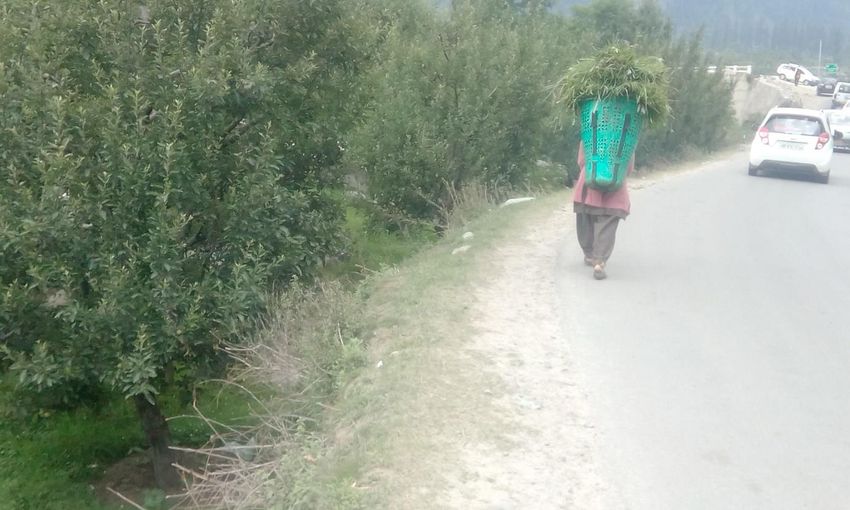
International Journal of Social Science and Economic Research
                                                                                     ISSN: 2455-8834
                                                                    Volume:04, Issue:01 "January 2019"

parts of Union Territory of Pudducherry and Andaman and Nicobar Islands are affected by
landslide hazard National Disaster Management Guideliness (NDMG, 2009). The alarming rate
and frequeny of landslide events increase during the monsoon period. In 2005, more than 500
human lives were lost due to this hazard (NDMG, 2009). Landslide hazard is the product of
combined interaction between geographical and anthropogenic processes (Smith, 1992). The
anthropogenic activities include changes in socio-economic activities as well as technological
activities such as transport, industry, agriculture, mining, forestry and impacts of urbanization
and tourism (Singh, 1991). In mountain areas such as Kullu to Rohtang Pass, the operation of
several potentially hazardous geo-physical process necessitates the use of multiple hazards
approach to the problem (Singh and Rowbotham, 1995). In the case of mountanious terrain,
landslide hazard prone area has been traditionally avoided and are used for agricultural activities
(Gurung, 1989). The Beas river catchment area from Kullu to Rohtang Pass is highly vulnerable
to landslide hazards and is frequently triggered by the rainfall in monsoon season. Slope failure
is also a major cause for landslide disasters in the study area. The diversity in slope components,
degradation processes, micro-climatic conditions, soil texture, physical and chemical properties
and unplanned growth of settlements have led to recurring landslide events in Kullu to Rohtang
Pass. In order to reduce the enormous potential effect of landslide and consequential loss, the
risk should be analysed in order to prepare an appropriate strategy or guidelines at district level
as well as national level. Bottom to top level approach would be helpful in the proper
implementation and functioning of structural and non-structural mitigation measures for
landslide risk and management with the help of mass awareness generation programmes.

2. STUDY AREA

The study area between Kullu-Rohtang Pass is located in Kullu valley, Himachal Pradesh, India.
Geographically, this area lies between the latitude 32° 0’ 0’’ N to 32° 20’ 0’’ N and longitude
77° 5’0’’E to 77° 15’0’’E along the catchment area of fast flowing Beas river (Figure 1). The
study area is situated in the transitional zone between lesser and greater Himalayan Mountain
ranges in the central part of Himachal Pradesh. Transport road corridors get frequent landslides
occurence especially during monsoon season. It has a rugged topography with moderate to high
altitude from 1,279 m to 3,979 m from Mean Sea Level (MSL).

www.ijsser.org              Copyright © IJSSER 2019, All rights reserved                    Page 108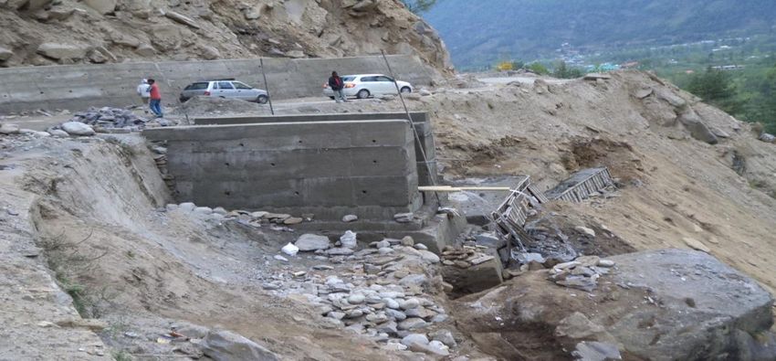
International Journal of Social Science and Economic Research
                                                                                  ISSN: 2455-8834
                                                                 Volume:04, Issue:01 "January 2019"

    Source: Prepared by Author

                 Figure 1: Study Area Between Kullu to Rohtang Pass

www.ijsser.org           Copyright © IJSSER 2019, All rights reserved                    Page 109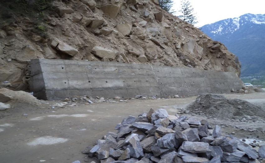
International Journal of Social Science and Economic Research
                                                                                      ISSN: 2455-8834
                                                                     Volume:04, Issue:01 "January 2019"

3. DATABASE AND METHODOLOGY

The study is based on primary and secondary database. The primary information has been
collected with the help of questionnaire and GPS. A semi-structured questionnaire has been used
for this purpose. The selection of respondents was done through stratified random sampling
method. The study area is divided into eight villages (4 between Manali-Rohtang Passs and 4
between Kullu –Manali) along the road corridor. About 25 respondents from each village were
selected from all socio-economic backgrounds. The questionnaire included questions related to
people perception about techniques and practices to mitigate and control the landslide risk. The
secondary information has been collected from different reports, magazines, research papers and
articles.

4. RESULTS AND DISCUSSION

The task of landslide hazard mitigation has to be a coordinated effort among the local authorities,
state government, central government and other stakeholders concerning the landslide prone
area. A number of factors such as the growth of urban centre, rural settlements and other
infrastructural developmental activities increase effectiveness of landslide hazard response and
landslide vulnerability (Mileti, 1994). The problems of landslide incidents in Kullu to Rohtang
Pass area can be effectively controlled, however, it requires proper management and planning
with sufficient financial resources and following structural and non-structural landslide
mitigation methods.

4.1 Structural Mitigation Methods

4.1.1 Stability of Slope

The stability of slope can be substantially increased by its enlargement at the toe of the landslide
and reducing the load of soil at the crown. Construction of man made hillside benching or
terraces can be effective in reducing the impact of landslide hazard (Figure 2). Such method is
used when the slopes are especially steep and the toe of the slide has been altered. Hillside
benching prevent the build-up of slope long stress and they should be designed for easy
maintenance.

www.ijsser.org               Copyright © IJSSER 2019, All rights reserved                    Page 110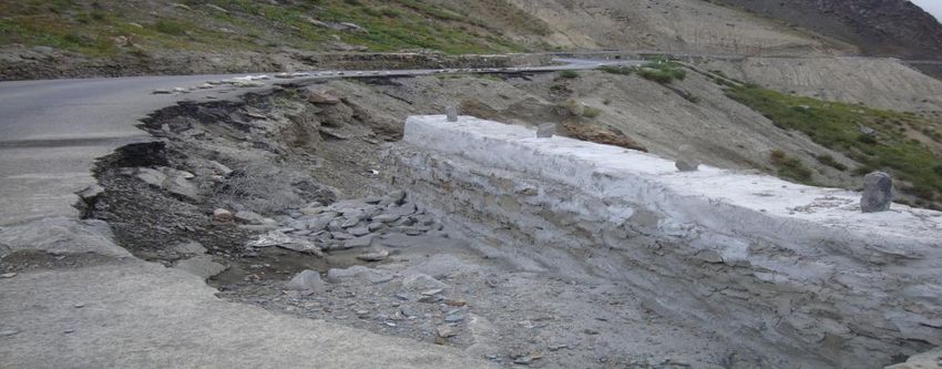
International Journal of Social Science and Economic Research
                                                                                     ISSN: 2455-8834
                                                                    Volume:04, Issue:01 "January 2019"

            Figure 2: Construction of Stability of Slope on National Highway-21

Road construction and growth of unplanned settlements along the steep slopes near the upper the
Beas basin area, Palchan and Kothi village are the main causes of slope instability in the study
area. So, the preventive steps should be taken by government to control these activities and
prepare a policy for slope based construction of settlements.

4.1.2 Drainage Techniques on Slopes

Drainage system is one of the important preventive measures to mitigate the slope instability in
many parts of the Kullu-Rohtang Pass. The lack of proper drainage system will continuously
affect the hills slopes and increase vulnerability of landslide events and make it even more prone
to landslides (Figure 3). Major landslide event at near Dawara village in Kullu district and Bhang
village in Manali area caused by drainage system.

www.ijsser.org              Copyright © IJSSER 2019, All rights reserved                    Page 111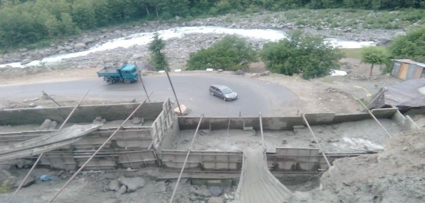
International Journal of Social Science and Economic Research
                                                                                     ISSN: 2455-8834
                                                                    Volume:04, Issue:01 "January 2019"

            Figure 3: Effect of Proper Drainage System in Bhang Village, Manali

The most important triggering mechanism for mass movements is the water infiltration into the
overburden during heavy rains and consequent increase in pore pressure within the overburden.
Hence, the natural way of preventing this situation is by reducing infiltration and allowing excess
water to move down without hindrance. As such, the first and foremost mitigation measure is
drainage course correction and promotion of water harvesting measures. This involves
maintenance of natural drainage channels both micro and macro in vulnerable slopes. If the
drainage system is scientifically planned and designed between Kullu-Rohtang Pass than future
occurrence of landslides events will decrease (Figure 4).

             Figure 4: Planned Drainage System Near Palchan Village, Manali

www.ijsser.org              Copyright © IJSSER 2019, All rights reserved                    Page 112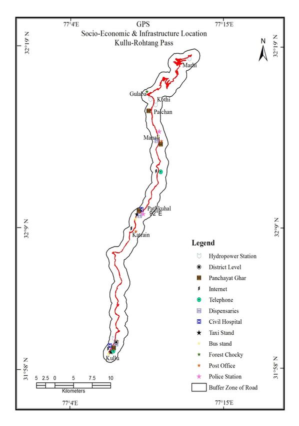
International Journal of Social Science and Economic Research
                                                                                     ISSN: 2455-8834
                                                                    Volume:04, Issue:01 "January 2019"

4.1.3 Retaining Wall

Construction of retaining wall along the road corridor and hilly slopes especially along the toe of
the hill to support the rock mass. The construction of retaining wall depends on techno-economic
factors and availability of the material.

Provision of sufficient weep holes with proper filtering is more essential for retaining structures
(Figure 5). The height of the retaining wall depends on the calculated risk factor of a particular
landslide spot. Construction of retaining wall in the study area is strongly recommended for the
Nehru Kund site to get the terrain stability as well as avoid further slope failure conditions.

                     Figure 5: Retaining Wall Near Nehru Kund, Manali

4.1.4 Rock Bolts

Rock bolts is used to prevent movement of rock slopes or stabilize rock slide. It is one of the
suitable methods of rock mass support especially where rock is cut vertically. The use of this
method has become popular in certain situations in last few years. They work best in rocks that
are joined with planes of discontinuity inclined downslope. They are usually composed of steel
rods that are inserted at angles to the planes of weakness. A rock bolt reduces the disturbing
force acting down the plane of discontinuity and increases the relationship between the base of
the block and the plane.

4.1.5 Wire Mesh Crates

www.ijsser.org              Copyright © IJSSER 2019, All rights reserved                    Page 113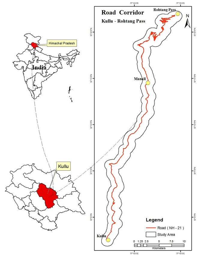
International Journal of Social Science and Economic Research
                                                                                     ISSN: 2455-8834
                                                                    Volume:04, Issue:01 "January 2019"

It is a systematic arrangement of uniformly cut rock blocks within the wire mesh. It requires
proper network of wires along the toe of the hill and it reduce the vulnerability of landslide
incidences. The Public Works Department (PWD), in Kullu district has already adopted this
measure.

4.1.6 Contoured Benches and Terraces

This method is proposed in the erosion prone areas along with planting of tress and grasses.
Vulnerable sites are identified in the study area and are suggested for construction of contour
benches and terraces to control the erosion in the landslide hazard prone areas.

4.1.7 Cement Grouting

This method is used for making of inclined drill holes in to hill mass and it is fillet by cement
with pressure through pump. In this method cements spread entirely in gaps between the rocks
and shears plane resulting in completely blocking of the weak plane, hence reducing the
vulenerability of landslides.

4.2 Non-Structural Mitigation Methods

4.2.1 Plantation

Slope stability movements are generally disturbed by deforestation, overgrazing activities and
removal of vegetation cover from the land surface. The afforestation on the slopes sides is an
important corrective measure to mitigate the landslides (Figure 6). Trees or shrubs are planted
from time to time on the slope as they create a dense network of roots in the soil and a canopy
over the surface. Trees and shrubs planting methods can be applied on 35 0-450 slopes. Planting
grass lines protect the slope and conserve the soil as they reduce the speed of run off with the
help of their roots. This method is applied on 350-600 slopes. The planting of large bamboos
reduce movement of slope material and stabilise slope in the upper the Beas basin area.

www.ijsser.org              Copyright © IJSSER 2019, All rights reserved                    Page 114
International Journal of Social Science and Economic Research
ISSN: 2455-8834
Volume:04, Issue:01 "January 2019"
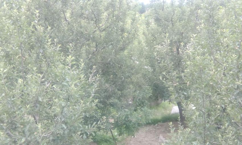
Figure 6: Apple Orchard Near Palchan Village, Manali
Some other methods like grass seeding, tree or shrub seeding, bamboo planting and turfing
reduce landslides impacts and it holds some potential applicability between Kullu-Rohtang Pass
area.
4.2.2 Proper Utilization of Land
The land use planner should make the local people understand about the importance of land use
planning. But deforestation, urbanization, industrialization, exploitation of resources, heavy
building construction and engineering structural work, etc. increase the landslide vulnerability.
Thus, proper scientific land use planning and ban on non-biodegradable materials is the need of
the hour. The scientists and engineers should arrange mass awareness camps to increase
geological, geo-hydrological investigation practices. They also make local people understand
about the importance and uses of eco-friendly building materials in landslide prone areas. The
afforestation programmes should be effectively implemented as the preventive measures for the
landslides (Figure 7). The selection of suitable plants species should be done in such a manner
that can reduce the existing stress conditions of the terrain.
www.ijsser.org Copyright © IJSSER 2019, All rights reserved Page 115International Journal of Social Science and Economic Research
ISSN: 2455-8834
Volume:04, Issue:01 "January 2019"
Figure 7: The Afforestation Programme Near Kulang Village, Manali
4.2.3 Socio-economic and Infrastructural Database
The socio-economic and infrastructural database system plays an important role in landslide
disaster management during emergency and post emergency phases. An extensive field survey
using GPS was carrried out to locate and to map available socio-economic and infrastructural
facilities required for the management of landslide disaster and mitigation of their risks in the
study area (Figure 8). Community buildings also play a vital role during rescue and relief phase .
There are only 4 community buildings in the study area (Table 1).
www.ijsser.org Copyright © IJSSER 2019, All rights reserved Page 116International Journal of Social Science and Economic Research
ISSN: 2455-8834
Volume:04, Issue:01 "January 2019"
Table 1: Existing Socio-economic and Infrastructural Database, Kullu-Rohtang Pass, 2016
Socio-economic and Infrastructural Database Existing GPS Kilometer Location
Administrative centers Police station 3 Kullu (0.7), Patlikuhal (23.7),
Manali (38.2)
Patwari station 1 Kullu (1.5)
Post office 4 Kullu (2.0), Patlikuhal (21.3),
Manali (37.4)
Forerst chocky 1 Gulaba (60.4)
Transportation Bus station 3 Kullu (0.0), Patlikuhal (22.5),
Manali (38.0)
Taxi station 2 Kullu (0.1), Manali (38.0)
Medical centers Civil hospital 2 Kullu (0.3), Manali (38.3)
Dispensary 3 Kullu (0.9), Patlikuhal (22.6),
Manali (37.1)
Public communication centers Telephone 3 Kullu (0.4), Manali (38.6),
Katrain (31.4)
Internet 3 Kullu (0.4), Manali (38.6),
Katrain (31.4)
Community bulding Panchayat ghar 4 Kullu (0.5), Patlikuhal (22.8),
Manali (36.3), Palchan (51.1)
Disaster interpretation center District level 1 Kullu (0.9)
Water supply Hydropower 4 Kullu (2.1), Palchan (51.0),Kothi
stations (54.6) , Marhi (84.3)
Source: Field Survey, 2016
www.ijsser.org Copyright © IJSSER 2019, All rights reserved Page 117International Journal of Social Science and Economic Research
ISSN: 2455-8834
Volume:04, Issue:01 "January 2019"
Source: Prepared by Author
Figure 8: Socio-Economic and Infrastructure Location Between Kullu-Rohtang Pass
www.ijsser.org Copyright © IJSSER 2019, All rights reserved Page 118International Journal of Social Science and Economic Research
ISSN: 2455-8834
Volume:04, Issue:01 "January 2019"
5. PEOPLE’S PERCEPTIONS REGARDING LANDSLIDE RISK MITIGATION
5.1 People’s Perceptions Regarding Techniques and Practices to Mitigate the Occurrence
of Landslide Events.
The basic skill knowledge, technical expertise, economic status and level of mass awareness of
local community are the important tools by which we can control and mitigate the landslide risk
between Kullu-Rohtang Pass. The control over deforestation, afforestation, toe-wall and slope-
based construction programmes in the study area are the four most preferred techniques which
have reduced the impact of landslide risk and mitigate the occurrence of landslide events (Table
2). All the 200 respondents have shown their 100 per cent dedication and keenness to undertake
these four mitigation techniques in landslide hazard control.
Table 2: People’s Perceptions Regarding Techniques and Practices to
Mitigate the Occurrence of Landslide Events
S. Mitigation Techniques Landslide Hazards
No. No. of Respondents Percentage
1. Afforestation 200 100
2. Control over deforestation 200 100
3. Construction of reservoirs 180 90
4. Control on overgrazing 150 75
5. Better drainage techniques on 172 86
slopes (along the road)
6. Agro-forestry 38 19
7. Control on construction of houses 93 46.5
in the vulnerable area
8. Proper utilization of land 140 70
9. Check on urban sprawl/ tourism 35 17.5
10. Toe-wall 200 100
11. Slope based construction 200 100
12. Planting trees on slopes 104 52
13. Others 00 00
Source: Based on Primary Survey
www.ijsser.org Copyright © IJSSER 2019, All rights reserved Page 119International Journal of Social Science and Economic Research
ISSN: 2455-8834
Volume:04, Issue:01 "January 2019"
Apart from the above four mitigation techniques, the construction of reservoirs and better
drainage techniques on slopes are the important techniques responded by 180 and 172
respondents respectively. Control on overgrazing and proper utilization of land are also other two
important mitigation techniques to control and mitigate landslide hazard occurrences responded
by 150 and 140 respondents respectively. In the study area, only 17.5 per cent respondent’s
perception is along with the check on urban sprawl/ tourism mitigation techniques for reduce the
landslide risk.
5.2 People’s Perceptions Regarding Awareness of Government Initiatives to Mitigate the
Landslides.
A better understanding between government initiatives and local community participation plays
an important role to mitigate the landslide events. The local communities between Kullu-
Rohtang Pass have very strong faith and high appreciation for the government initiatives in
construction of toe-wall and afforestation programmes. 100 per cent respondents have shown
their positive perception for construction of toe-wall as well as afforestation programmes (Table
3).
Table 3: People’s Perceptions Regarding Awareness of Government
Initiatives to Mitigate the Landslides
S. No. Government Initiatives Landslide Hazards
No. of Respondents Percentage
1. 185 92.5
Construction of check dam
2. 200 100
Afforestation
3. 195 97.5
Posting danger zone sign
4. 143 71.5
Campaigning through media
5. 200 100
Making stone-toe wall
6. 70 35
Establishment of slopes by plant cover
7. 50 25
Forecasting/warning by different
departments
8. 00 00
Others
Source: Based on Primary Survey
www.ijsser.org Copyright © IJSSER 2019, All rights reserved Page 120International Journal of Social Science and Economic Research
ISSN: 2455-8834
Volume:04, Issue:01 "January 2019"
In the landslide prone areas, the government of Kullu has displayed danger zones signs to
prevent causalities. 195 respondent’s perception is positive regarding government initiatives.
Campaigning through media is also another good initiative by government for landslide
mitigation in Kullu valley.
5.3 People’s Perceptions Regarding Initiatives of the NGO’s to Mitigate the Landslides.
The social development of any place, region or community is reflected by their social and
economic activities. A large number of Non-Governmental Organizations (NGOs) are engaged
in social activities. The upper part of the study area is a typical mountainous area having a large
scope for development for the NGOs. Cooperative societies in Kullu like Himalayan Adventures
Cooperative Society, Mahila Cooperative Agricultural Service Society, etc. are working for the
mitigation of landslide events. The afforestation initiatives by NGOs for the mitigation of the
intensity of landslide occurrences has been liked by 200 respondents (Table 4).
Table 4: People’s Perceptions Regarding Initiatives of the NGO’s to Mitigate the landslides
S. No. NGO’s Initiatives Landslide Hazards
No. of Respondents Percentage
1. Construction of check dam 00 00
2. Afforestation 200 200
3. Posting danger zone sign 30 15
4. Campaigning 70 35
5. Opposing urbanization & Tourism 30 15
6. Education for mass awareness 25 12.5
7. Financing 00 00
8. Others 00 00
Source: Based on Primary Survey
The campaigning of the occurrence of landslide hazard are also done by NGOs. In the study area,
70 respondents are in favour of this NGOs initiative. The programmes for opposing urbanization
and spread of education for mass awareness were also initiated by the NGOs to control and
mitigate the impacts of landslide hazard. About 15 and 13 per cent respondents have replied in a
positive way regarding the initiatives of the NGOs to mitigate landslide hazards.
www.ijsser.org Copyright © IJSSER 2019, All rights reserved Page 121International Journal of Social Science and Economic Research
ISSN: 2455-8834
Volume:04, Issue:01 "January 2019"
5.4 People’s Perceptions Regarding Village Level Performance to Mitigate the Landslide
Events.
The perception and positive involvement of community in any decision making process at
village level is good for the mitigation of landslide risk. The upgraded level of awareness
generates integrated development of society or collective approach which is able to face any
problem and create new innovative ideas. The panchayat level or bottom to top level approach
has been adopted to control landslide hazard. Social forestry programme at village level between
Kullu-Rohtang Pass is done mainly for the mitigation of landside occurrences (Table 5). On an
average about 97.5 per cent of respondents have shown their positive perception for this
programme to control landslide hazard.
Table 5: People’s Perceptions Regarding Village Level Performance
to Mitigate the Landslide Events
S. No. Performance Landslide Hazards
No. of Respondents Percentage
1 195 97.5
Social forestry
2 148 74
Construction of check dam
3 130 65
Helping government personnel
4 40 20
Mass level campaign
5 57 28.5
Opposing the tourism and urbanization
6 00 00
Others
Source: Based on Primary Survey
The construction of check dam is also done by the village panchayat. On an average 74 per cent
respondents acknowledge this activity. In the study area, people are also involved with
government personnels by visiting different departments and providing latest information
relating to the probability of landslide occurrences. 65 per cent respondents favoured this
standpoint. The mass level campaigns rellated to landslide mitigation is also done by a limited
number of respondents in the study area.
www.ijsser.org Copyright © IJSSER 2019, All rights reserved Page 122International Journal of Social Science and Economic Research
ISSN: 2455-8834
Volume:04, Issue:01 "January 2019"
5.5 People’s Perceptions Regarding Individual Efforts to Mitigate the Landslide Events
The people’s perception observed in study area is very positive and optimistic as 180
respondents are in favour of plantation of trees and are willing to do on individual level, 82
respondents are even ready to do villiage level campaigning for spreading mass awareness in
order to mitigate the landslide events and 42 respondents replied in favour of opposing the
tourism and urbanization (Table 6).
Table 6: People’s Perceptions Regarding Individual Efforts to
Mitigate the Landslide Events
S. Individual Efforts Landslide Hazards
No. No. of Respondents Percentage
1. Plantation of trees 180 90
2. Visiting different departments and 38 19
collecting information
3. Village level campaign 82 41
4. Helps through NGO’s 10 5
5. Financial helps 5 2.5
6. Campaigning through media 16 8
7. Opposing the tourism and urbanization 42 21
8. Others 00 00
Source: Based on Primary Survey
The campaigning through media and individual efforts like visiting different departments and
collecting information is also done by a limited number of respondents.
5.6 People’s Perceptions Regarding Awareness of the Institutions in Controlling the
Landslide Events.
Research on landslide hazard mitigation between Kullu-Rohtang Pass also includes the level of
awareness and perceptions of the local people’s regarding the institutions that are engaged in
monitoring and controlling the landslide hazard events. In the study area, Border Road
Organization (BRO), Snow Avalanche Study Establishment (SASE), Western Himalayan
Mountaineering Institute (WHMI), Public Work Department (PWD), Health and Irrigation
Department (HID), Divisional Forest Office (DFO), Himachal Pradesh Tourism Development
www.ijsser.org Copyright © IJSSER 2019, All rights reserved Page 123International Journal of Social Science and Economic Research
ISSN: 2455-8834
Volume:04, Issue:01 "January 2019"
Corporation (HPTDC) and District Revenue Office (DRO) are positively working for landslide
hazard mitigation (Table 7).
Table 7: People’s Perceptions Regarding Awareness of the Institutions
in Controlling the Landslide Events
S. No. Institutions Landslide Hazards
No. of Respondents Percentage
1 Border Road Organization (BRO) 200 100
2 Snow Avalanche Study Establishment 173 86.5
(SASE)
3 Western Himalayan Mountaineering 48 24
Institute (WHMI)
4 Public Work Department (PWD) 200 100
5 Health and Irrigation Department (HID) 30 15
6 Divisional Forest office (DFO) 45 22.5
7 Himachal Pradesh Tourism Development 18 9
Corporation (HPTDC)
8 District Revenue Office (DRO) 00 00
9. Any other Institution 00 00
Source: Based on Primary Survey
Border Road Organization (BRO) has been highly aplauded by all 200 respondents for
controlling the landslide hazard between Manali-Rohtang Pass followed by Public Work
Department (PWD) between Kullu-Manali while 173 respondents are in the favour of Snow
Avalanche Study Establishment (SASE) working for monitoring the landslide and snow
avalanche hazard.
6. CONCLUSION
It can be concluded that the proposed integrated landslide risk mitigation plan can be classified
into pre-disaster, during-diastar, post-disaster phases, which are based on the engineering and
non- engineering mitigation methods. Strategies for landslide awareness generating programmes
by social as well as administrative systems, have been helpful in the mitigation of the impacts
www.ijsser.org Copyright © IJSSER 2019, All rights reserved Page 124International Journal of Social Science and Economic Research
ISSN: 2455-8834
Volume:04, Issue:01 "January 2019"
of landslide events in the study area. Early warning systems such as Geographical Information
System (GIS), Remote Sensing (RS), Global Position System (GPS) are proved to be useful
towards landslide disaster management, preparedness and mitigation at all levels. GPS based
socio-economic infrastructural location mapping has emerged as the boon for it is used for the
community evacuation plan which is based on place centered mapping. Primary survey of
people’s perception regarding landslide risk mitigation is the main source to know the awareness
and preparedness level of the local communities. In the nutshell it can be said that there is a
positive response for the techniques and methods implemented by the governmment and even
local people are ready to participate in the process if given a chance to mitigate the landslide
risks.
REFERENCES
Gurung, S., (1989). Human Perception of Mountain Hazards in the Kakni-Kathmandu Areas;
Experiences form the Middle Mountains of Nepal. Mountain Research and Development.
9 (4): 353-364.
Mileti, D.S., (1994). Public Response to Flood Warning. Kluwar Academic Dordrecht,
Netherlands. 257: 549-563.
National Disaster Management Guideliness (NDMG)., (2009). Management of Landslides and
Snow Avalanches. New Delhi: 2-3.
Singh, R.B., (1991). Geographical Monitering of Himalaya Highland-Lowland Interactive
System. National Geographical Journal of India. 37 (3): 272-281.
Smith, K., (1992). Environmental Hazards: Assessing Risks and Reducing Disasters. Roultedge
Publication. London.
Singh, R.B. and Rowbotham, D., (1995). The Imortance of Natural Hazrds Research to the
Himalaya Region: Himachal Pradesh, a Case in point in V.K. Sharma (ed.) Himalaya
Eco-development and Natural Disaster Reduction. National Centre for Disaster
Management. Indian Institute of Public Administration. New Delhi: 1-14.
www.ijsser.org Copyright © IJSSER 2019, All rights reserved Page 125You can also read