Land at Rectory Farm, Yatton - Mead Realisations Ltd Prepared on behalf of - Design & Access Statement: Outline - North Somerset Council
←
→
Page content transcription
If your browser does not render page correctly, please read the page content below
Land at Rectory Farm,
               Yatton
      Design & Access Statement:
                         Outline
                    DATE 23.12.2020

           Prepared on behalf of

     Mead Realisations Ltd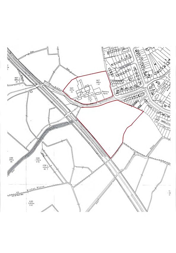
Document No.   Status     Date            Revision   Author / Checked

xx             Planning   December 2020              SM/ IR
Contents

Executive Summary                                  4.0   Design Principles

1.0   Introduction and background                  4.1   Design strategy
                                                   4.2   Building with Nature
1.1   Introduction                                 4.3   Residential development - Housing density
1.2   Purpose of the document                      4.4   Routes and trails
1.3   Application content                          4.5   Views
1.4   Description of the proposal                  4.6   Attenuation
1.5   The application site                         4.7   Ecology
1.6   Site context
1.7   Planning context

                                                   5.0   The Proposal

2.0   Factors shaping the development              5.1   The illustrative layout
                                                   5.2   Access and movement
2.1   Constraints and opportunities                5.3   Amount and use
2.2   Ecology                                      5.4   Scale and density
2.3   Topography                                   5.5   Parking
2.4   Trees and hedgerows                          5.6   External Lighting Strategy
2.5   Access and transport                         5.7   Landscape strategy
2.6   Designations                                 5.8   Energy and Sustainability
2.7   Heritage
2.8   Flood risk and drainage
2.9   Visual Impact
                                                   6.0   Summary

                                                   6.1   Summary
3.0   The Vision                                   6.2   Key Benefts

3.1   The Vision

                                        Land at Rectory Farm, Yatton - Design and Access Statement   | 3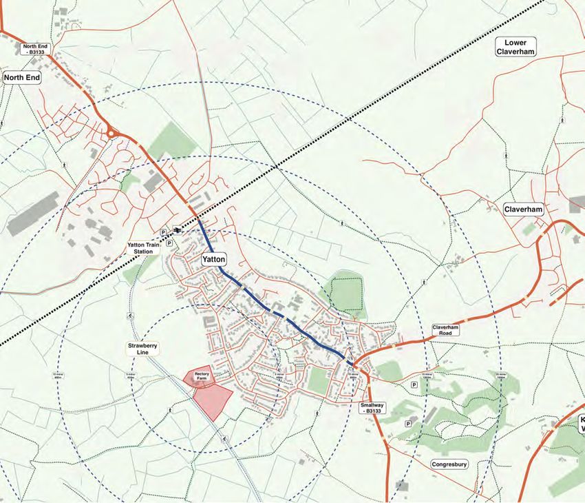
Executive Summary

Executive Summary

The enclosed Design & Access, Planning Statement, and
associate consultants’ reports have been prepared by
APG Architecture, and are submitted on behalf of Mead
Realisations Ltd., in support of an application for outline
planning permission for up to 100 dwellings on land at
Rectory Farm, Yatton.

•   This Design & Access Statement sets out the
    relevant design, access, and planning issues.

•   They are informed by the submitted plans and
    other supporting reports.

•   They collectively demonstrate that the proposed
    development is acceptable in terms of Local and
    National Planning Policy, and accordingly the
    application should be granted.

                                                  Land at Rectory Farm, Yatton - Design and Access Statement   | 5
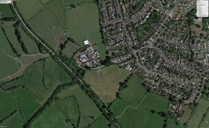
1.0 Introduction and Background
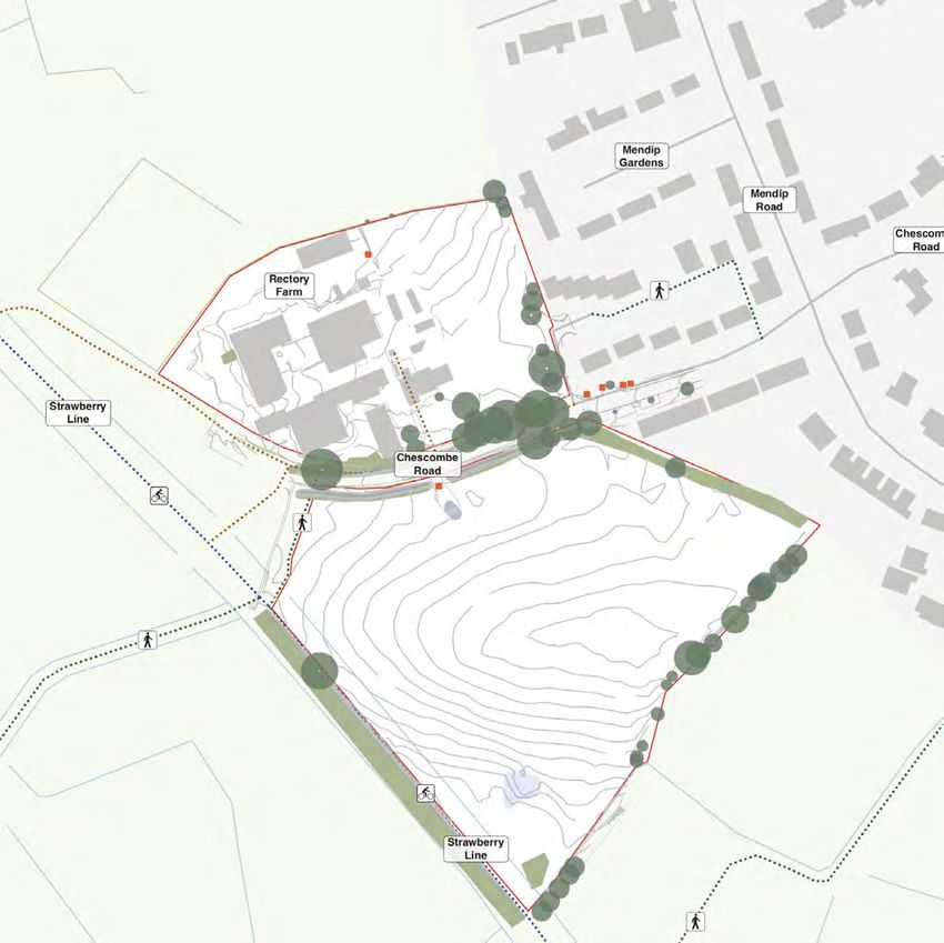
R   OAD
                                  CO MBE
                              E S
                            CH

Application Red-line Area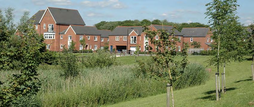
1.0 Introduction and Background

1.1 Introduction                                            1.3 Application content

This design and access statement has been produced          This Design and Access Statement is to be read in
in support of an outline planning application for a         conjunction with a suite of other documents and
residential development on land at Rectory Farm,            drawings that provide further detail about specifc areas
Yatton. It has been prepared by APG on behalf of Mead       of the applications.
Realisations, with expert assistance from Walsingham
Planning, Hydrock (Transport & Drainage) and Veridian       These documents include:
Landscape (Landscape and Visual Impact) and Clarkson
                                                              •   Planning Statement;
Woods (Ecology).
                                                              •   Transport Assessment / Statement;
The planning application is made in outline with all
                                                              •   Drainage and Flood Risk Assessment;
other matters reserved apart from means of access.
                                                              •   Phase 1 Ecological Report;
The proposal will provide a high quality residential
                                                              •   External lighting strategy and report
development and associated infrastructure, with
signifcant areas of public open space, SUDs, new tree         •   Arboricultural Survey;
and hedgerow planting, meadow planting, ecology               •   Landscape Strategy; and
mitigation areas and biodiversity net gain on the
western edge of Yatton. This can then be developed to         •   Illustrative Masterplan.
create an attractive and sustainable extension to the
town of Yatton.

The proposals consider how a new development
could relate positively to Yatton and the surrounding
countryside on a number of levels, providing a sense of
place, biodiversity net gain and building on the identity   1.4 Description of the proposal
of the local area.
                                                            The proposed development comprises a site area of 4.1
This document describes and illustrates proposals that      hectares and will provide the following:
have been developed from the initial pre-app response.
                                                              •   Up to 100 no. new sustainable homes (including
                                                                  market & afordable housing);
                                                              •   A range of dwelling sizes, types and tenures -
                                                                  including 1 and 2 bed apartments & 2, 3 & 4 bed
                                                                  houses with suitably sized gardens and associated
1.2 Purpose of the document                                       parking;
                                                              •   New community green space, walking routes and
The Design and Access Statement describes the nature
                                                                  Community Orchard;
and extent of the development proposals. It explains
how they respond to context and represent best                •   Managed areas of public open space (POS);
practice in urban design and sustainable design.              •   Strategic Landscaping, SuDs and other associated
                                                                  infrastructure.
It describes the process and design principles that
have informed the development of the masterplan,
landscape and architectural proposals.

                                                 Land at Rectory Farm, Yatton - Design and Access Statement    | 9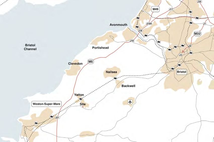
Transport connections
1.0 Introduction and Background
1.5 Planning Context 1.6 The Site in Context
A Planning Statement has been prepared by Yatton is a village in Somerset, England, situated 13.5
Walsingham Planning to accompany this application. miles South West of Bristol, 10 miles North East of
The statement considers the planning policy context Weston-super-Mare and 25 miles East of Bath.
relevant to the proposed development and reviews the
planning balance of considerations pertinent to the The closest villages are Cleeve and Congresbury which
proposed development. lie to the South of Yatton. The Bristol to Exeter train
line connects Yatton to Weston-Super- Mare, Bristol,
For the purposes of this application the Development Avonmouth, and through to Newport.
Plan for the Site comprises the North Somerset Core
Strategy (adopted in 2012, readopted 2017), the Sites The closest airport is Bristol Airport, 7 miles from Yatton;
and Policies Part 1: Development Management Policies accessible by bus via Bristol.
(adopted in July 2016), the Sites and Policies Plan Part
2: Site Allocations Plan (adopted April 2018) and the Yatton is well connected to its surrounding cities and
Yatton Neighbourhood Plan (made in July 2019). towns by the A370 which runs to the South of the town.
The M5 runs to the north of Yatton which can be joined
The North Somerset Core Strategy was formally to the South-West of the town at Junction 13.5 miles
adopted on 10th April 2012 and contains strategic from the site
policies to guide development in the District up to 2026.
A number of policies were also readopted in January A former railway line - the Strawberry Line, connecting
2017 following a high court challenge. This document Yatton with Cheddar, is now a designated National Cycle
supersedes the North Somerset Replacement Local Network route (26), for pedestrians and cyclists.
Plan (2007) and works alongside further documents to
provide guidance for new developments. Due to these strong rail and road links, the village has
increased in size over time. Now with a population
Policy CS13 of the adopted Core Strategy document of roughly 7000 people, the village is home to many
has set a target to deliver a ‘minimum’ of 20,985 commuters traveling to nearby towns or cities, including
dwellings in the plan period (2006 to 2026). Bristol, Bath and Weston-Super-Mare.
Policy CS32 sets out the Council’s approach to new Yatton has a predominantly residential land- use, with
residential development in Service Villages (which scenic views out to areas of farmland to the south west
includes Yatton). and open green spaces surrounding the outer edge of
the village.
The Sites and Policies Part 1 was formally adopted
on the 19th July 2016 and includes development There is a variety of shops, restaurants and medical
management policies which supplement policies in facilities within the village, which are mainly located
the Core Strategy. The Sites and Policies Part 2 which along the High Street.
includes site allocations was adopted on the 10th
April 2018. The Yatton Neighbourhood Development The site is well located to access these facilities, being
Plan was made on the 23rd of July 2019 following a within half a mile of the High Street, accessed via
successful referendum result on the 11th of April 2019. Chescombe Road.
The Neighbourhood Plan covers the period 2017-2026.
The Plan sets out a number of objectives relating to the To the north west of the site are various industrial
environment, housing and transport. estates and business parks, home to various
manufacturing facilities.
Further information on the planning policy context
and justifcation for the site is set out in the supporting
planning statement.
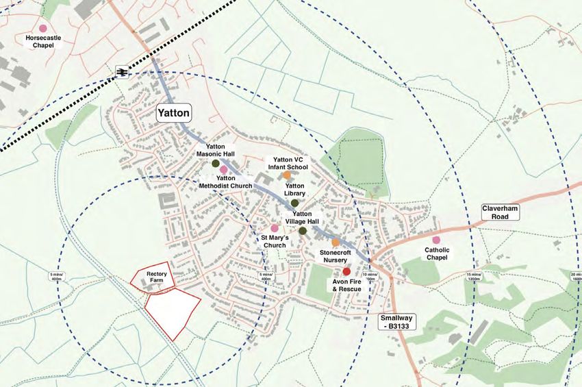
Land at Rectory Farm, Yatton - Design and Access Statement | 111.0 Introduction and Background
The railway station to the north, can be accessed via the 1.7 The application site
Strawberry Line cycle route with connections to other
settlements in the area and beyond. The site lies immediately to the south west of the
existing settlement edge at Yatton, and to the east of
Yatton has an Infant School and a Church of England the Strawberry Line cycle path. The Strawberry Line
Junior School which share a site. The schools are within is directly accessed from Chescombe Road via a path
0.7km of the site and therefore approximately 8 minutes adjacent to the western edge of the site.
in walking distance. There are no higher education
facilities such as a secondary school, sixth form or The site is is made up of two parcels of land; to the north
college. and south of Chescombe Road. Existing residential
development lies to the east, with pasture and felds
The village is home to two daycare/nursery facilities adjoining the remaining boundaries.
along with a village hall and three churches, helping
foster a strong community spirit. The site is bounded on all sides by mature hedgerows
and trees, with a narrow woodland belt forming the
Yatton is also home to a variety of diferent sports clubs western boundary with the Strawberry Line, which is
and activity centres, including a bowling, cricket and itself a local nature reserve. The hedgerow boundaries
football/rugby club. are also defned by the local rhines network which lie
adjacent a number of the hedgerows.
In addition to this there are also various parks and open
green spaces for the public to use, along with a local The site is connected to the village via Chescombe
nature reserve, and a bird of prey centre within a 15-20 Road, adjoining the High Street running through the
minute walk from the site. centre of the village.
Whilst there are no statutory designations on the site, a
Special Site of Scientifc Interest (SSSI) and Site of Nature
Conservation Interest (SNCI) lie to the east and west of
the site boundary.
A Listed building is located approximately 0.5km to the
west of the site at Cadbury Farm.
Land at Rectory Farm, Yatton - Design and Access Statement | 132.0 Factors Shaping the Development
2.0 Factors Shaping the Development
342600E
342650E
342700E
342750E
342800E
OS NORTH
Tree
h 8.0
7.47
7.31
7.22 RL
7.45
15.85
165300N 6.97
7.26
EL
Dry Ditch 6.78 7.04 13.26
7.79
6.65
6.86 7.65
6.57
6.54 6.71 7.47 7.74
6.62
5
6.36
6.7
8.06
6.74
6.7
6.65 7.16
7.62
6.7
4
9
6.79 7.03
6.7
6.46
CBF
5
6.86
Grass 7.32
6.8
7.
h
00
8.28
6.8
7
1.2
6.83
5
7.23
6.71
8.15
6.86 6.76 Grass
6.78
8.4
RL 6.89 J8 7.10 7.28
12.00 6.91
9
6.92 8.01
7.06
6.9
6.88
7.01
7
6.94 6.92 7.00 7.05
WP
6.96
6.93
7.64
7.1
6.96 6.97 Shed
6.96
6.78
Silage Storage - UTS
WF
EL 7.10
1
10.73 6.95 6.93
h 1.2
97 Conc 7.17
7.24
6.937.42
6.
7.03 7.08
Gvl
6.93
8.6
06 7.26 8.56
7.20
7. 6.95 1
7.0 Conc
1
6.92
7.13
6.94
7.4
7.07 Metal 7.41 7.62
7.09 6.99 6.96 Overgrown Private
3
8.72
6.93 Container Gardens 8.22 RL
Me
6.96 7.43 7.89
7.16 6.89 5 13.11
7.5
tal
7.08
7.37
CB
7.35
7.0
7.59
3 7.61
Co
7.11 6.94 6.98 7.6
7.0
Fh
Conc
7.70
J7 1 PO PO
nta
22
3 7.6
1 7.0
7.00 7.64
2.5
6.9 7.29 7.36 3
ine
5/25
7.2 7.04 PO 7.65
Gvl J9
Stat
9
8.66
r
4 7.36 6.98 PO
1
7.6 Tree
0Ø
Timber
7.74
7.3
7.0 7.0
7.6
7.00 8 7.63
ic Ca
Pile 8 7.5 7.74 7.82 h 7.0 EL
7.3 RSJ
0
1 6
Stati
8
7.3 7.22 7.65 7.6 11.07
7.32 7.36 7.25 gh
Trou
rava
RSJ 9
7.7 PO 22
7.14
c Ca
7.33 7.63 7.6 8.42 5/2
0
4
7.76 50
n
8.
7.53 RSJ Conc 7.81
7.7
7.34 7.39 7.21 FWIC Ø
rav
0
00
7.7
6.50 7.63
8.51
7.31 Conc
7.7
7.18 1 EL 7.7
4
an
CL 8.69
7.48
9 7.3
5
7 10.26 8.20
6.7 7.29
7
7.33 Trough 7.4 IL 7.08 8.55
7.33 Tree 8.3
7.48 7.80
8.44
7.39
7.8
Former Grain Store h 9.0 9
Machinery Storage -
9
8.53
7.8
8.00
- Dilapidated 8.01
7.9
UTS 7.15 GY
7.97
7
7.39
7.07
7.36
8.04
5
DK
RL n 8.40
7.99
9
rava
8.5
8.4
6.4
12.56
7.33 8.00 c Ca 8.07
3
2
Brambles
8.14 Stati Tar
8.46
8.4
165250N 7.09 7.91 h 2.5 8.43
CB
8.37 TTL
0
Trough 7.42 8.41
8.32
6
7.0
7.9
7.98
8.05
6.78
8.4
8.41
Fh
8.0
1
Overgrown Private
5
Conc Open 6 GY
1.1
6.93
h 1.1 7.8 1 J10
4
8.37
7.66
8.43
Gardens 8.56
7.4
Sided CW ough 7.6 8.08 8.28 LP
8.50
6 2
Tr 8.6
7.9
1
6.82 Barn 1 8.0
6.93 7 7.4 8.00 Grass
1
7.6 EL n 1
7.4
rava
6.90
h 1.1 Stay TP 8.37 8.6
11.10 c Ca
0
7.41 CW
Stati
8.25
7.97
8.1
SW
PO 7.30 Tree
8.0
6.89 RL 7.95 8.24
7
7.48 12.30
6.86
Greenhouse h 12.0
0
3
h 1.4
8.16
6.48 GY 7.0
J6 6.89 8.31
7.5
7.18
7.99
EL
8.05
Silage Storage - UTS Skip 7.36
8.42
11.05 8.19 8.14
2
6.57 Storage 7.21 Conc 8 8.11
8.1
6.86
RL
7.2
6.88 8.01 3 8.16
8.37
8.1
6.86 14.01 3 CW h 1.2 8.1 ETL
TTL
8.25
0 7.5 CPS
7.4
7
Grain 8.04 Conc J99 8.28
7
GY 7.39
8.0
Col 7.5 8.14
7.19
8.1
Store
8.1
CBF
TTL
W IC EP 3.1 RL h 1.2 SC
9
8.18
7
CR 8 RSJ EL 8.07 Tree Chain 8.66
4
7.09 J5B CL 8.16
6.8
6.56 Gvl Col 15.48
7.2
7.27 7.6 CRW 11.63
h 1.0
h 18.0 8.21
8.10
gh 8.04
7.2 0
6.86 Open 2 8.10
TT
9
7.42 7. Trou RSJ 8.1 TT 8.61 8.58
6 7.86 Conc
L
Fuel
6.8
1
Sided 2 L
7.5
6.8
8.39
8.0
6.69 7.04 7.8 RL
8.1
Barn O/H nk 8.01
8.54
8
6
9
12.12 8.11
7.08 Col
8.07
Ta
8.13
4
Chain
6.87 RSJ GY RL TT 8.64
7.79 7.93 8.06 Tar L PO SC 8.51
8.26
6.79 13.12 EL PO Tar
7.56 8 8.41 8.55
8.14
Col 7.80 7.82 7.9 EL 10.92 TTL
ETL EL 8.44 8.59
7.3
EP
h 1.4
7.5
8.1
7.75 all 7.88 11.54 8.45 DK
er W 8.69
6
6.70 8.10 13.46
Conc Dutch 8.14 8.11
h 1.6 8.48 Grass
9
IC
4
ep 8.35
8.1
Barn GY 7.66 3 J&
Sle
7.81 Pipe underwater RL
CL 8.00 CBF 8.59
8.20 SC 8.34
6.8
7.7
8.65
2
RS
8.09
7.01 Col 8.06 IL 7.19 10.79 SC 8.43 DK 3
8.24
8.0
8.00
7.60
4
2 8.7
7.98
A/C Unit
8.15
6.8
7.7
7.8 3 8.10 8.07 8.40 8.55
7
J5A 4 8.11 SC
7.5
9
6.83 8.3 8.01 BTIC
8.07
6
6.80 Col 8.0 8.06 DK
0
GY 8.33
1 iner Gvl S 7.96
3 8.62
8.36
CP 8.16
6.83
7.7 J1 8.18 SC
Conta
8.1
Conc 7.62 RL RL 7.97 SC 8.47 h 1.0
EL ge 8.02 TP RF
8.27
7
1 11.91 8.11
ora 0 EP LP
8.41 WP
9
7.06 7.7 12.35 8.02 SC
8.
8.20 Tar
7 10.37 tal St
8.0
6 7.98 DK
6.81 Col 7.3 7.6 Me 8.02 8.06 8.00 GY IC GY
DK
ST03 Tar 8.56
6.80
6.77 W 9 Tree 7.95
SW 8.41
CR 7.6 EL 7.97 CL 7.95 8.06
5 8.20 Grass SC 6
7.86
Trailer / Caravans / 7.5 9 7.34 8.09 SNP SC 8.5
6.8
7.1 Parked 8 10.89 h 12.0 7.94
Col 0 7.9 h 1.
7.98 Stay 8.29
7.98
8.0
SV
8.0
Debris etc - UTS
2
7.6 J2 EL Gas
7.00
7.09 7.10 7.40
Trailer - 4 8.09
6.75
1
Grass 7 8.47
4
IC-Water
4
6.78 UTS RL 11.32 8.0 7.9 8.00 Grass 8.35
6.94
Conc 7.60 8.05
7.96 7.94 8.12 CL 7.95 FH
Gvl 7.11 7.89 12.41 8.01 8.20 Tar
6.7
9 EL 7.89 EL
11.38
7.93
Tree LP
6.93 7.96
8.00
11.10 7.88 h 1.0
7.9
7.82 Conc - IC? h 22.0 WF 7.79 7.98 8.10 8.31 8.38 8.33
7.82 Tree
CB
7.80
WP 9
3
7.9
6.64 3 RL 7.91 7.7 6 7.85 8.15 8.22
7.92
6.72 6.9 Open 6.9
7.88 h 8.0 8.38
Fh
7.9
6.67
4
6.77 13.52
6.85
Sided Gvl 7.84 7.91 0
5
7.81 7.98
7.89
7.78
1.8
6.9
7.6
7.87
7.81 Gvl
6.85
6.57 J5 Barn 7.80 7.76 6 7.80 7.86 8.06 1.2
EL 4
Conc 8 7.7
8.20 WH
0
J1A
7.
6.7
8
7.6
12.03 7.83 7.98 CB
6.5
Bin
6.8
7.7
6.5 Open 7.83
1
4 Ditch 7.82
7.78
7.5
6.93
6
6.60
6.85 7.65 Sided 7.78 9 6.92
7.6
6.6 7.80
6. Conc 7.95
7
6 7.6
9
6.6
7 Barn 7.7 1.8 8
6.9
6 7.59 Fh
7.
8
6.5
Gra Vegetation Shed 7.47
7.67
6.04 6.46 Grass CB 7.66
7
4
ss Boundary not visible
6.13 6.29 Gvl h 1.2
7.74
5 Tar
6.64 7.30
7.5
0 7.73 7.75
6.57
6.8 PO
7.6
7.6 7.56 RL
6.51
6.96 7.37 7.9 7.00
7.09 7.62 2
He
0 RL
7
4 7.6
7.60
3
165200N 6.10 6.26 6.70 6.86 Conc 7.66 9 7.3 4 7.57 Bra 16.23
dge
7.62 7.65 12.40 6.2 7.6 mbles
7.39 7.63 7.47
7.37
8 Vegetation
7.00
7.58
7.70
7.49
7.7 2.2
6.29
6.89 Chicken
6 1.5 7.53
h 2.
7.05 h 1.2 eh Culvert Outfall
7.
7.5
7.46 Coop Hedg
7.5
EL 7.58 9 7.4
7.57
IL 6.73
0
6 7.5 6
0
7.64
6.35 6.25
7.
4
11.52 Gvl
6.25 6.7 7.35 7.48 7.66 J3
7.57
6.2
5 7.3
4
7.5
7 7.30 PO 7.49 7.53 7.57 EL
5 7.71
7.26 7.37
7.
7.64 7.56 7.59 7.14 Tree 7.4
59
8 9 13.65
6. 7.53
7.34
35 7.47 7.59 7.53 7.5 7.2
5 h 12.0 7.51 7.50
6.25 7.4 7.56 Culvert Outfall 7. 7.55 6.55 7.26
0 J4 7.62 7.67 29 7.61 6.55 He CL
7. 7.51 Gvl IL 6.19 Fh
7.30
Timber
7.30 4 7.36
6.34 7.4 dge 1.4
7.60
7.55
Pile 2 Pipe 225Ø 7.36 7.43 9 h 2.2
7.39 7.5 7.25
6.16 h 1.0 7.35
6.3 7.20 7.36 7.52
7.29
Tar 7.51 6 WF 7.5
9
7.16 WP 0
0
7.13 Tree 7.21 Ditch 2 7.1 Ditch 7.2
h 22.0 7.44
Hedge h 3.0 5.95 7.20 ST02 7.63
7.24
7.28 1 7 7.22 8.0
5.51 6.2 1.5 7.32 2
6.2 eh
7.14 7.1 Hedg 7.13 WP&
2.1 6.34 6.93 7.15 7 Tar W/F
6.70 7.28 7.29 Grass 7.66 h 1. 7.88
He
dge
6.37 Tar 6.50 7.13
6.20 6.95 7.03 7.15 6.84 7.05 7.14
0 h 1.5
6.54 6.73 6.86 7.50
6.38 7.49
5.9
3
6.57
7.03 6.76 7.10 Culvert Inlet Pipe
8.06
7.
6.06 Ø300 7.85
6.16
6.08 6.22
01
6.75
6.84 Ditch IL 6.35
6.35 PO
7.0
6.71 8.10
Culvert Outfall 5.30 5.80 6.80 7.10 Ap
5
6.00 6.79 prox
7.
7.50
08
IL 4.77 5.82 Culvert Outfall Gvl 7.29 7.9 imate
WP WF h 1.0 6.55 7.83 8
PO
6.14
6.26 5.78 IL 6.13 Ce
h 2.0 7.10 ntre
6.15 Hedge 6.85
8.1
4 Lin
3
6.55 6.96 8.22 e of He
7.0
Culvert Inlet 6.19
7.1
6.30 6.41 6.38 7.60 dge
6.11
IL 4.91 7.74 8.22
0
6.16 h 0.5 6.36 6.75 7.32
6.24 8.21
7.
7.97
6.09
7.9
00
Grass 8.24
8
6.66 7.12 7.50
6.93 7.51 Bram
8.21 bles
7.09 8.04
6.50 PO 7.24 h 1. CBF h 1.2
6.05 5
6.05
6.13
7.56 7.73
6.78 8.23 8.2
6.30 PO 4
8.
7.94
7.23 8.11
00
6.20 PO
6.81
8.23
6.10
7.54
7.82
6
7.27
7.8
6.02 7.70
otpath
6.65 Grass
0
8.0
8.13
l Fo
7.55
7.25 8.07
1.0
7.80 7.90
Grave
6.29
6.56
h
/F
W
P&
7.21
W
165150N 6.44
7.52
7.94
8.12
h 1.0
7.86 8.08
Grass 7.11
WF
7.42
WP
6.20
9
8.16
7.9
6.96 7.91 8.19
7.97
2
7.36
7.5
Grass
6.22
6.82 8.20
7
8.0
Trees
7.97 7.99 h 8.0
8.28 8.26
7.32
6.28
6.56
8.20
7.93 8.10
6.43
7.21 8.
6.25
6.33 00 8.38 8.34
6.18
00
6.2
7.83 8.36
2
8.
8.13
h
6.96
Ditc
5.85
6.0
8.49
0
7.74 8.48 8.28
6.69
5.8
6.56
8.07
6
6.68
1
3
8.0
7.5
6.1
Brambles
6
6.44 7.49 8.66
7.95 8.52
8.43
7.30
1
3
8.0
8.34
6.33 8.54 8.57
6.97 7.74 8.51
4
8.39
7.8
6.3
2
7.4
Ditc
8
6.69 8.58
h
8.41
7.38 8.50
6.5
Grass 8.41
9
8.62
7.07 8.23 Tree 8.33
8.39 h 16.0
Tree
h 12.0 6.80
6.83 8.30 Dry Pond
8.46 W
7.88 SR
6.6
6.71
7
8.1
8.15
7
8.39
5.3
7.54
6.6
165100N 8.26
2
1
8.23 9
8.2
7. 8.41
00 7.11 7.81
6.4
0
8.06
7.9
8
6.79 8.15
7.43
6.57
7.92
8.00
6.3
5
7.91
7.66
7.88
ABBREVIATIONS 6.93 7.64
General 6.43 7.72
7
7.5
6.3
7.38
h 1.2
(A) Approximate LB Letter Box 6.3 7.75
1
8 6.54
WMF
Ave Average Ldr Ladder 7.01 7.46
5
7.54
5.9
(AR) Assumed Route LP Lamp Post
7.3
7.06
6.2
He
6
8
dg
6.66
BB Bottom Bank MH Manhole
e
6.
h
3.0
00 7.15
BBn Belisha Beacon MK Marker 6.53 7.26
0
6.1
7.2
BD Bollard Mon Monument
3
7.29
6.75
5.6
9
6.22
Bin Litter Bin NB Notice Board
6.6
Grass
7
6.06
6.97
Bldg Building o/h Overhead 7.20
7.01
6.42
BL Bed Level o/l Outline of
7.00
5.6
BTIC BT Inspection Chamber
Ditc
6.72
2
h
6.85
Cab Cabinet Pav Paviors 6.01 6.86
h 1.0
CE Cable TV Entry Point PGM Permanent Ground Marker
5.5
6.19 6.61
WP&W/F
6.56
8
CEK Concrete Edging Kerb PI Pipe Into Ground
6.29
5.5
6.46
CI Cable Into Ground PKN Parker Kalon Nail
4.3
5.89
9
6.51 Grass
7
5.90 6.51
CL Cover Level PM Parking Meter 6.25 6.42
5.66 6.45
CM Cable Marker (R) Records 6.39
6.45
Col Column RE Rodding Eye 5.59 6.47 6.45
5.4
5.71
2
Conc Concrete RL Ridge Level 5.71 6.31
5.91
5.90
CP Concrete Post RL Roof Level 5.78 5.93 5.97 6.37
W
P
CPS Concrete Paving Slabs RS Road Sign
W
5.86
/F
5.88
5.76
h
CT
He
Cable TV IC RSJ Reinforced Steel Joist
5.90
1.
0
dg
5.56 5.72
e
5.56
D Duct Rub Rubble 4.67
h
2.0
5.97
5.
d Depth RWC Rain Water Channel
49
6.00
5.57 6.06
DF Drinking Fountain SA Soakaway 5.50
3
5.8
Grass
Dil Dilapidated SB Sign Board 5.54 5.91
69
Waterlogged
DK Drop Kerb SD Slot Drain
5.
4
5.65
5.7
5.55 Ground
DM Duct Marker SEK Stone Edging Kerb
0
5.61
2.
Dn Down Shb Shrub Bed
h
5.67
bles
DP Rainwater Down Pipe SL Soffit Level
Ditc
m
Bra
5.6
5.56
h
ne
1
Ea Earth SN Sign
Rhy
5.
5.51
5.52 5.73
00
EC Electricity Cable Outlet SP Soil Down Pipe 5.60 Trees
5.38
EIC Electricity Inspection Chamber Sub Substation 5.66
h 7.0
5.6
EL Eaves Level SV Stop Valve
3
5.64
Nettles /
5.70
Bushes h 2.0
EM Electricity Meter SVMK Stop Valve Marker
5.49
EP Electricity Pole SVP Soil Vent Pipe
He
5.64 5.60
dg
5.67
ER SWIC
e
Earthing Rod Storm Water Inspection Chamber
h
3.0
ETL Electricity Transmission Lines SY Stay 5.59
5.68
5.75
FB Footbridge Tac Tactile Paving ABBREVIATIONS
4.5
5.69
W
5.65
FD French Drain Tar Tarmac
0
P
W
Fences
/F
FEsc Fire Escape TB Top of Bank
h
1.
0
5.65
FH Fire Hydrant TCB Telephone Call Box AI Angle Iron EF Electric Fence
FHMK Fire Hydrant Marker TLt Threshold Level CP Concrete Post IRF Iron Railed Fence
5.
56
FL Floor Level TLt Traffic Light MP Metal Post IWF InterWoven Fence
5.74
Flb Flower Bed TP Telegraph pole PO WP Wooden Post MHR Metal Hand Rail
Flp Flag Pole TPS Textured Paving Slabs MPR Metal Post & Rail Fence
Flt Floodlight TrHt Tree Height Bar Barrier Pa Closed Panel
FP Footpath TTL Telephone Transmission Line BWF Barbed Wire Fence Pal Pallisade
342600E
342700E
342750E
FWIC Foul Water Inspection Chamber u/g Underground CB Crash Barrier RF Railed Fence
Gbn Gabions Up Up CBF Close Boarded Fence Sec Security Fence
GM Gas Meter UTR Unable To Raise ChP Chestnut Paling Tr Trellis Fence
GMK Gas Marker Veg Vegetation CIF Corrugated Iron Fence WMF Wire Mesh Fence
GP Gate Post VP Vent Pipe CLF Chain Link Fence WPR Wooden Post & Rail Fence
Gr Grass VT Vent
GT Grease Trap w Width Walls
GV Gas Valve WL Water Level BL RW Retaining Wall
Block
Gvl Gravel WM Water Meter B Brick W Wall
GY Gully WMK Water Meter Marker C Concrete
h Height WO Wash Out DB Devon Bank
Hc Hardcore WP Wooden Peg DS Dry Stone
HN Hilti Nail WT Water Tap S Stone
IC Inspection Cover VL Unknown Valve
IL Invert Level
KO Kerb Outlet
Survey Station Co-Ordinates Note:
Co-Ordinates are based on National Grid This survey is an extension of survey drawing C-07567-C TS01 Project: Drawing Title:
Station
(OSGB36(02) Co-Ordinates to a scale factor of 1
Easting Northing Level
issued 04-08-2017. The original survey has not been checked
to establish whether the details provided within this drawing LAND AT RECTORY FARM TOPOGRAPHICAL SURVEY
Topographical Survey; Hydrock
are still current or accurate.
YATTON
J1 342644.066 165219.036 8.065 Due to the amount of vegetation, timber, vehicles, silage store,
J2 342628.921 165215.410 7.899 skips and general debris at the time of survey we cannot
J3 342628.796 165196.292 7.602 guarantee that all necessary features have been captured. Over Court Barns, Over Lane, Almondsbury,
Bristol, BS32 4DF.
14730
J4 342598.876 165193.619 7.470
J5 342577.025 165206.663 6.749 TEL: 01454 619 533 FAX: 01454 614 125 or visit Project Number:
J6 342567.967 165238.205 6.893 www.hydrock.com Client:
J7 342592.283 165265.284 7.380
J8
J9
J10
342627.773
342636.054
342638.885
165280.831
165263.559
165245.827
6.876
7.713
7.955
This drawing is the copyright of Hydrock Ltd. No liabilty will be
accepted for any amendments to this drawing either printed or
digital by parties other than Hydrock.
MEAD REALISATIONS LTD Drawn: Checked: Scale @ A1: Drawn Date:
JWH PLS 1:500 23/07/2020
First Issue:
23/07/2020
J99 342640.730 165236.284 8.068
INFORMATION
J1A 342665.113 165208.676 7.850 Notes:
J5A 342603.309 165222.852 7.652 All dimensions are to be checked on site before the commencement of works. Drawing Status.
J5B 342597.567 165232.959 7.325 Any discrepancies are to be reported to the Architect & Engineer for
14730-TS01 Revision -
ST02 342660.984 165188.401 7.293 verification. Figured dimensions only are to be taken from this drawing.This
ST03 342729.462 165219.847 8.044 drawing is to be read in conjunction with all relevant Engineers' and Service Drawing No.
|
Rev Date Description By Ckd
16 Land at Rectory Farm, Yatton - Design and Access Statement
Engineers' drawings and specifications. This drawing is copyright.2.0 Factors Shaping the Development
2.1 Constraints and Opportunities Where the development is unable to fully mitigate for
impacts to foraging greater horseshoe bats within the
Sited on the edge of the village of Yatton, this site site, additional of-site habitats have been identifed and
currently has ecological value that requires careful secured to compensate for anticipated impacts.
design to retain and enhance where possible. The
proposal has therefore been prepared in close It is recommended that the development incorporates
consultation with Hydrock Ecology, and a detailed a comprehensive and integrated landscape and green
Ecological Report accompanies the application. infrastructure strategy that seeks to avoid, reduce and
mitigate efects as far as possible.
Expert consultation has also been employed on the
subjects of Flood Risk, Landscaping, External Lighting, Specifc issues addressed by the proposals include:
Heritage and Transport; each of which are extensively
covered by accompanying reports. • Provision of a dark corridor designed for
commuting and foraging horseshoe bats across
the southern, western and northern boundaries
and provision of a lighting plan covering all
2.2 Ecology external lighting proposed.
There are no sites designated for nature conservation • A suitable additional area of of-site foraging
within the application boundary. The Strawberry Line habitat for horseshoe bats
runs along the western edge of the site and ditches
associated with this form part of the Biddle Street SSSI • The retention and conservation of reptiles
and Cheddar Valley Railway Path SNCI. The site also falls within the red line boundary
within Zone B of the North Somerset and Mendip Bats
SAC Consultation Zone for greater horseshoe bats. • Appropriate mitigation to ensure the badger
sett identifed is protected from disturbance
The site contains a number of habitats of ecological
value including agricultural pasture bounded by For a full Ecological Impact Assessment including the
hedgerows of varying quality and a farmyard which detailed mitigation measures please refer to
includes a number of agricultural structures. Outside of Clarkson and Woods Ltd EcIA report submitted as
the site are a number of predominantly dry ditches and part of the application.
to the west wet ditches are present which are associated
with the Biddle Street SSSI.
eDNA survey has confrmed the likely absence of
Great Crested Newts within nearby ponds. Further
species-specifc survey has been undertaken for bats 2.3 Topography
(particularly greater horseshoe bats), reptiles and
badger in line with best practice guidance. The site generally slopes from east to west with steeper
areas falling down to the south of the site.
Appropriate opportunities have been identifed within
the development to mitigate for and enhance habitats Areas of 1 in 10 and steeper form a constraint to general
within the site for a range of species. Maintaining and development although majority of the site is relatively
enhancing semi-natural areas including the hedgerow fat and has a slope of 1 in 20.
network, open grassland, and native trees.
The development also proposed the creation of a
number of new habitats including SUDS containing
open water, native hedgerows and a traditional orchard.
Land at Rectory Farm, Yatton - Design and Access Statement | 172.0 Factors Shaping the Development
Connectivity
Views to the East towards St Mary’s Church, Yatton
18 | Land at Rectory Farm, Yatton - Design and Access Statement2.0 Factors Shaping the Development
2.4 Trees and Hedgerows There is a vital PROW which runs directly from the site
to the Strawberry Line cycle path. This forms a key link
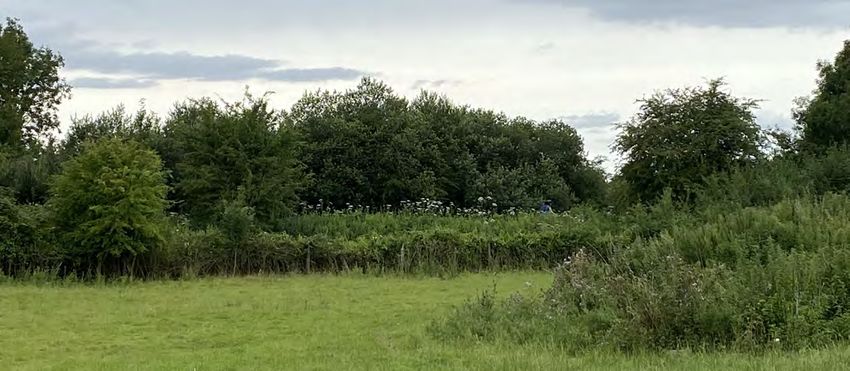
The site is bounded on all sides by mature hedgerows to the greater area and provides access to surrounding
and trees, with a narrow woodland belt forming the countryside and green spaces.
western boundary with the Strawberry Line, which is
itself a local nature reserve. The hedgerow boundaries Additional footpaths are located to the south of the
are also defned by the local rhines network which lie site running to the east and towards Yatton itself. Links
adjacent a number of the hedgerows. to the west provide walking routes to surrounding
countryside.
These existing hedgerows, trees and rhines, will be
retained and enhanced to provide screening, maximise
ecological opportunities and respond to the rural edge
character of the site.
2.6 Designations
Further detail is supplied in Clarkson Woods’ report,
supporting this application. There are no statutory designations on the site.
However a Special Site of Scientifc Interest (SSSI) and
Site of Nature Conservation Interest (SNCI) lie to the east
and west of the site boundary.
2.5 Access and Transport The Strawberry Line also forms part of a local nature
reserve.
Yatton is well connected to its surrounding cities and
towns, such as Bath, Bristol and Weston-Super-Mare, by
the A370 which runs to the south of the village.
Yatton train station considerably improves the town’s 2.7 Heritage
connectivity by making it easy for residents to commute
to larger neighbouring cities in search for employment. There are two listed buildings within a 10 minute walk of
the site, so the impact of development on the setting on
The town itself is well connected by buses along the the listed buildings has been taken into consideration in
High Street and by three main roads leading into the relation to this.
village (Claverham Road, Smallway and North End).
Land at Rectory Farm, Yatton - Design and Access Statement | 192.0 Factors Shaping the Development
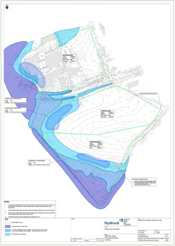
Flood Zones; Hydrock
20 | Land at Rectory Farm, Yatton - Design and Access Statement2.0 Factors Shaping the Development
2.8 Flood Risk and Drainage The site has a framework of boundaries comprising
hedges, some with mature trees, with the potential
Large sections of the site are classifed as being within for enhancement and further strengthening with
Flood Zone 1/Flood Zone 2 and at low/medium risk new hedge and tree planting using native species
from fuvial/tidal sources. It is within the areas that characteristic of the area. Additional enhancements
development is being proposed and this is in line with include the planting of a community orchard. The
policy. Whilst areas of the site are shown as being at development would result in a beneft to vegetation on
an increased risk, the proposlas are for these areas to the site.
be utilised as public open space through a sequential
approach to site use. Views of the development would be limited to
mainly local views, close to the site, owing to existing
The southern area of the site includes a 5m ditch development, the framework of substantial mature tree
easement around the perimeter and the northern site cover and the landform.
has an easement in the north east corner.
Adverse efects would largely be confned to the site
Further detail is supplied in Hydrock’s report, and its immediate setting. They would be minimised
supporting this application. by the implementation of the landscape proposals,
underpinned by a long-term Landscape Management
Plan, which would ensure the retention and
enhancement of the boundary trees and hedgerows,
2.9 Visual Impact and the sustainability of the new landscape proposals.
Key elements of the landscape strategy for the site The land predominantly surrounding the residential
include: area of Yatton is moorland, with both rolling valley
farmland and limestone, ridges and combes land on the
• retention and protection of all existing eastern side.
boundary hedges;
The eastern edge of the site sits on the boundary of
• management and enhancement of existing Yatton’s existing development, and its western side sits
boundary hedges; adjacent to the Strawberry Line cycle path.
• provision of publicly accessible open space The site is screened by mature vegetation to most of the
around the periphery of the site, south west and south eastern boundary. In some areas
this will require reinforcement to minimise the impact
• providing bat corridors; on the Strawberry Line.
• implementation of new landscape proposals
with a high percentage of native species, in keeping
with the setting of the proposed development and
to provide ecological mitigation and enhancement;
and
• implementation of a long-term Landscape
Management Plan.
Land at Rectory Farm, Yatton - Design and Access Statement | 213.0 The Vision
3.0 The Vision

  an ecologically enhanced setting

  community orchard                                                         attractive public open space

  inhabited house frontages give passive surveillance over public open spaces
3.0 The Vision

3.1 The Vision                                                 •   Retention of the existing rhines and
                                                               watercourse through and adjacent to the site.
The Vision for the site has been developed around a
number of overarching design considerations:                   •    Maintaining and enhancing the existing public
                                                               rights of way and links to the site as key pedestrian
The key aspects of the plan have been designed to              and cycle connections.
respond to the constraints across the site, of fooding
and drainage, landscape and ecology.                           •   Creation of a strategic bat corridor on the
                                                               western edge of the site.
These issues are addressed, alongside the over-arching
principles of place-making, and the desire to create        The key place-making drivers include:
a high-quality residential development, set within an
attractive and ecologically rich landscape, for the new        •     Responding to the local and site context to
inhabitants and wider community                                reinforce a sense of place.

The concept plan below illustrates how these elements          •    Shared surface approach to public realm to
could come together;                                           create streets and spaces that allows vehicles and
                                                               people to cohabit safely.
The key fooding and drainage drivers include:
                                                               •    Addition of orchards to refect the local
   •    Retain existing rhines and watercourses.               landscape character.

   •    Maintain existing fooding areas, omitting              •    Locating the play space and community uses as
   development from them and providing above                   part of a multifunctional landscape accessible to all.
   ground attenuation features within the landscape.
                                                               •     Low density housing wrapping around the
The key landscape and ecology drivers include:                 rural edges of the site. that relates well to the
                                                               surrounding countryside and creates an outward
   •      Focusing the development onto a green                looking neighbourhood.
   corridor that encloses the site and retaining the
   hedgerows along Chescombe Road that divide the              •    Good pedestrian connections through the site
   site into two distinct halves.                              connecting to the existing public right of ways and
                                                               cycle paths.
   •   Retention of all the existing hedgerows and
   mature trees where possible.

                                                                                  attenuation lakes enhance
new walking routes for residents         wildfower planting                       biodiversity
and wider populace

                                                Land at Rectory Farm, Yatton - Design and Access Statement       | 25
4.0 The Approach Land at Rectory Farm, Yatton - Design and Access Statement | 27
4.0 The Approach

  Attenuation lakes help provide ecological diversity

  Mature hedgerows and trees to be retained and enhanced
4.0 The Approach

4.1 Design strategy                                          4.5 Views

Having consulted so thoroughly on matters of ecology         The land predominantly surrounding the residential
and landscaping, the confguration of the layout has          area of Yatton is moorland, with both rolling valley
become driven by a desire to provide a scheme that will      farmland and limestone, ridges and combes land on the
be harmonious with its surroundings (both built and          eastern side.
natural)
                                                             The eastern edge of the site sits on the boundary of
Within this, generous green space has been allocated,        Yatton’s existing development, and its western side sits
with a view to fostering a sustainable and connected         adjacent to the Strawberry Line cycle path.
community, that is beyond the aspiration of the
majority of modern housing developments.                     Detached houses are distributed sparingly along the
                                                             southern and eastern edges of the development,
4.2 Building with Nature                                     overlooking wide green spaces within the site curtilage,
                                                             and to the mature hedgerows and trees of the
The layout is derived with full sensitivity to the           Strawberry Line beyond. Generous views of these green
ecological setting of the site, particularly in respect of   spaces are also available from within the development,
the bat habitat corridor that is to be nurtured along the    through the generous gaps between these rural edge
south-eastern and south-western boundaries.                  properties.
The mature hedgerows and trees that surround the
site have nurtured a landscape-led approach to the           AMture trees and hedgerows to the south and eastern
scheme, where the generous landscaping within the            boundaries are to be suitably enhanced, in order to
development area is to complement the context in             provide a green screen, restricting views into the
which it sits. Further detail is supplied in Hydrock’s       development from these vantage points.
report, supporting this application.
                                                             4.6      Attenuation
The green spaces are given an inhabited housing
frontage, with well placed housing frontages providing       A hydrology study of the site has been undertaken,
passive surveillance, whilst low-key private roads with      and a series of three attenuation lakes incorporated
low-level lighting and hedgerows further support the         accordingly. These are suitable sized to accommodate a
rural feel of the rural edge of development.                 level of residual water year-round, which will help these
                                                             lakes to contribute to the breadth of ecological diversity
4.3 Housing density                                          within the site. Further detail is supplied in Hydrock’s
                                                             report, supporting this application.
Houses fronting onto the site’s proposed central
access road, refect the relatively dense grain of the        4.7 Ecology
surrounding estates, where a mix of two storey semi-
detached and terraced units prevail.                         These existing hedgerows, trees and rhines, have been
                                                             retained and enhanced to provide screening, maximise
The density graduates down to a looser grained rural         ecological opportunities and respond to the rural edge
edge, towards the western and southern edges of the          character of the site.
development.
                                                             Substantial green swathes have been allocated around
4.4 Routes and trails                                        the south and western edges of the development, to
                                                             provide suitable bat habitat. Further detail is supplied in
New public access pedestrian routes are proposed             Clarkson Woods’ report, supporting this application.
within the site, providing generous access, particularly
along the western green-space. This will include routes
in and around a new Community Orchard.

                                                Land at Rectory Farm, Yatton - Design and Access Statement        | 29
5.0 The Proposals
49 2B
B
CENTRAL E
V AT
ATTENUATION
PRI
LAKE 50
2B
3B
3B
2B
51
GREY 3B
48
SHADED 52
2B
AREA
DEPICTS ACCESS TO 47
LAND TO 40 53
FLOOD ZONE
NORTH OF SITE
3B
77
78 41
2B
4B
2B 54
2B
2B
2B 46
42 3B
V
V
79 3B V
82 81
80 43 V
2B
2B V
2B 45
3B
3B
2B
83
2B
2B 87
4B
2B 76 86
3B
2B
GREEN
2B 75 85 3B
74
SPACE 73
2B
40
4B
3B
72
71 2B
70 V
84 2B 44
59 58 V
69
60
3B 39
62 61 3B
63 3B
NORTHERN 64 3B 4B 38
3B 3B
4B
ATTENUATION 65 3B
66 3B
LAKE
3B GREEN
2B 3B
3B
36 37 33
67 2B SPACE
3B
3B
4B 2B
89 2B 94
3B
68
92
93
PR
35
V V IV 34
90
91 AT
ER
3B
3B V
88
OA 4B
V
3B D
AD
4B
GREEN RO
SPACE 56
55
OM
B E 4B
57 ESC 13
CH 14
15
6-92] 16
2B [x 2B
2B
BIDDLE STREET 1 2] 17
[x 3B
3B 1B 3B 18
2 19
4B
20
3 4B
2B
V 21
V 3B
2B
4 8
3B 3B
5 4B
3B
2B
AD 22
RO
2B
E 49 2B 6
CENTRAL AT
IV
B
ATTENUATION
PR
3B 2
3B
50 7
LAKE
2B
2B
3B
3B
31 COMMUNITY AD
2B
3B 2B
23
51 RO
GREY 3B
48
30 ORCHARD
3B AT
E
SHADED IV
52 29 PR
2B
AREA 28
DEPICTS 47 24
40 53 27
FLOOD ZONE 26
3B
2B
41
4B
54 2B 25
3B
46
42 3B 3B
3B V 3B
43 V
45 2B V
3B V
2B
4B
3B
40
44 3B
3B
3B 39
3B V
38 V
4B 3B
GREEN 32 PUMPING
36 37 33 ACCESS TO
SPACE STATION
LAND TO
PR
35 EAST OF SITE
IV 34
AT
ER
OA
D
4B GREY SHADED
SOUTHERN
4B ATTENUATION AREA DEPICTS
LAKE
FLOOD ZONE
COMMUNITY
ORCHARD
GREY SHADED
AREA DEPICTS
FLOOD ZONE
TENURE KEY:
AFFORDABLE HOUSING PLOT [29 NO.]
MARKET HOUSING PLOT [66 NO.]
2B
2B
GENERAL NOTES: REVISION LOG:
1. CONTRACTOR TO CHECK ALL DIMENSIONS ON SITE. FIGURED DIMENSIONS ARE TO BE USED. DISCREPANCIES TO BE REPORTED TO THE
ARCHITECT BEFORE PROCEEDING.
GENERAL NOTES: REVISION LOG: PROJECT: SHEET SCALE: STATUS:
2. THIS DRAWING IS COPYRIGHT
1. CONTRACTOR TO CHECK ALL DIMENSIONS ON SITE. FIGURED DIMENSIONS ARE TO BE USED. DISCREPANCIES TO BE REPORTED TO THE
1037 - LAND AT RECTORY FARM, 1:500 @ A1 S1
ARCHITECT BEFORE PROCEEDING.
2. THIS DRAWING IS COPYRIGHT SHEET TITLE:
YATTON STATUS DESCRIPTION:
Site Masterplan DRAFT
SHEET NO: REVISION NO:
PROJECT ID: ORIGINATOR: ZONE: LEVEL: TYPE: ROLE:
FILE NAME: /Users/mariakrupa/Documents/1037 YATTON/1037-PL01:02 Yatton Masterplan and Tenure plan.vwx REV: BY/CHECKED: DATE: COMMENT
CRI - APG - XX - ZZ - SH - A PL01 /
FILE NAME: /Users/mariakrupa/Documents/1037 YATTON/1037-PL01:02 Yatton Masterplan and Tenure plan.vwx REV: BY/CHECKED: DATE: COMMENTYou can also read