Regional Profile of the Kittiwake Region - May 2013 Prepared by: Janelle Skeard, Jen Daniels, Ryan Gibson, and Kelly Vodden Department of ...
←
→
Page content transcription
If your browser does not render page correctly, please read the page content below
              Regional Profile of the
                Kittiwake Region


                               May 2013

                             Prepared by:
       Janelle Skeard, Jen Daniels, Ryan Gibson, and Kelly Vodden
                       Department of Geography,
                           Memorial University

Introduction
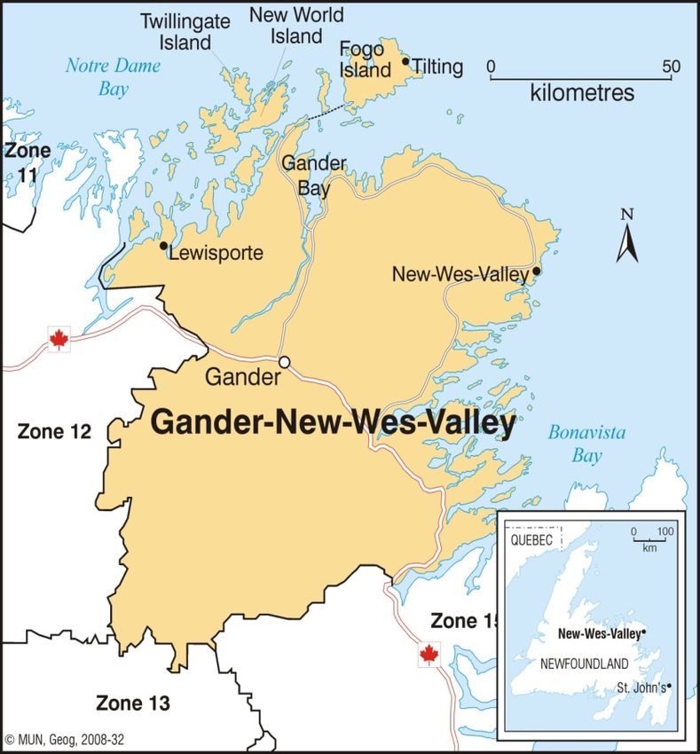
The Kittiwake region is located on the north eastern coast of the Island portion of Newfoundland
and Labrador. The region consists of approximately 120 communities, spanning west to
Lewisporte, east to Charlottetown, and north to Fogo Island (see Figure 1). Most of these
communities are located in coastal areas and are considered to be rural in nature. Only six
communities within the region have a population of over 2,000, with Gander being the largest
community and the primary service centre for the Kittiwake region (KEDC, 2007, p.2). The
region also encompasses three inhabited islands that are accessible only by ferry: Fogo Island,
Change Islands, and St. Brendan's (KEDC, 2007, p.2).
Figured 1: Map of Kittiwake Region
Regional Profile of the Kittiwake Region 2

Brief History
The region’s history is vast. Many communities have their own diverse history, which
collectively paints a picture of the historical basis of the Kittiwake region. Aboriginal occupation
is the first noted settlement in many parts of the region. Around 5,000 years ago, what we now
call Bonavista Bay was inhabited by Aboriginal settlers. The area was appealing due to its
abundance of resources such as seal, salmon and caribou. Additionally, the geological make-up
of the area was a resource for early Aboriginal settlers as it provided the means to manufacture
stone objects and tools (Burnside Heritage Foundation, 2012). In Notre Dame Bay, the Boyd's
Cove Beothuk site is the larger of the two sites in Notre Dame Bay (Pastore, 1999). The site is
located on top of a 6 metre high glacial moraine and spans approximately 3,000 square metres.
After an assessment of the area in 2007, Indian Bay was noted as “an area with considerable
potential to yield both pre-contact and historic archaeological sites” (Schwarz, 2009, p.6).
Moving away from sole Aboriginal occupation, Change Islands was settled in the latter part of
the eighteenth century by those seeking to take advantage of the fish resources in the area in the
English Labrador fishery, but prior to this until 1783 Change Islands was an unpopulated part of
the French Shore (Change Islands Centre for the Arts & Traditional Culture, 2012). Fogo Island,
was first settled in the 1680s by fishermen who “sought refuge from the French raiders
terrorizing the East Coast and Beothuks who harassed the Europeans on the mainland of Notre
Dame Bay” (Explore Newfoundland and Labrador, 2010, n.p.). The Twillingate area is where
merchants from Poole, England, including the Slades, Nobles, Earles and Duders, established
trade in the mid 1700s (Explore Newfoundland and Labrador, 2010). In 1794, Reverend George
Smith arrived in Bonavista Bay in hopes of spreading Methodism into the area (Piper, 2000). In
fact, Carmanville takes its name from Reverend Albert Carman, acknowledging the significant
role played by the Methodist Church in settling the region (Decks Awash, 1983). The town was
renamed after Carman in 1906, however, the area had been settled by English residents since
1825 (Canadian Webs, 2012). Similarly, Lumsden which was originally named Cat Harbour was
renamed in 1885 for Methodist minister James Lumsden (Explore Newfoundland and Labrador,
2010). Gander Bay, which was once part of the French Shore was overlooked by settlers until the
early 1800s- perhaps because Newfoundland was valuable to the fishing industry, and Gander
Bay is “shallow and too far from the fishing grounds of Hamilton Sound to have been seen as a
suitable area for settlement” (Decks Awash, 1983, p. 9). Many communities in the region can
also boast of a rich heritage that includes Aboriginal settlers; Gander Bay and Clarke’s Head are
two such areas (Decks Awash, 1983).

Regional Profile of the Kittiwake Region                                                          3

Physiographic Description
The region consists of 119 communities (six of which have a population of over 2,000) and a
population of approximately 46,000 spanning over about 14,000 square kilometres of land
(Kittiwake Strategic Economic Plan, 2009). The region also lies within the boreal shield ecozone
(Vodden, 2009, p.115). This ecozone includes stretched of trees, water bodies such as lakes and
rivers, as well as exposed bedrock. While this ecozone has been exposed and opened to use
transportation networks, many parts of it still remain sites of scenic wilderness (Bell, 2002).
There is a continental climate found in this ecozone, meaning that it includes long, cold winters
and short, warm summers. The vegetation found within the ecozone includes conifers and
broadleaf trees as well as lichens and shrubs in areas of exposed bedrock (Bell, 2002). The
wildlife representing the ecozone consists of various mammals including the black bear, lynx,
marten, woodland caribou, and moose as well as bird species such as the blue jay and loon (Bell,
2002).

Demographics Profile
Recent demographic changes tell a story of a region facing demographic challenges, including
the out-migration of skilled labour, a declining birth rate, and an aging population. All of these
factors challenge the future sustainability of the region (KEDC IBP, 2012).

According to Census data for the 2006 Census period, the region had a population of 46,850, a
decline of 3.6% from the 2001 Census period (Community Accounts, 2012). In 2006, the median
age for the region was 44, while the median age for the province was 42. The median age is
projected to rise to 51.6 in 2021, higher than its Newfoundland and Canadian counterparts at
49.3 and 42.2 years respectively (KEDC IBP, 2012, p.10). In 2010, the region experienced 370
births, a 7.5% decrease from 2009 when there were 400 births.
The population decreases experienced in the Kittiwake region are not universal; a number of
communities actually reported increases in population. Communities experiencing increases
include: Gander (11.1%), Lewisporte (5.3%), Terra Nova (22.1%), Appleton (6.9%), Centreville-
Wareham-Trinity (3.5%), Glovertown (2.9%), Glenwood (3.8%), Lumsden (2.3%), and Hare
Bay (1.1%) (KEDC Newsletter, 2012; Statistics Canada, 2012).
One of the major demographic trends that will affect the region is an increasing rate of decline
among the working age population. During this period, a large portion of the baby-boom
generation will move into retirement combined with fewer young workers available to enter the
labour market and replace retiring workers (KEDC IBP, 2012, p.11).

Regional Profile of the Kittiwake Region                                                             4

        Table 1. Population Change in the Largest Kittiwake Communities, 2006-2011

          Community                             2011 Population               2006-2011 Population
                                                                                    Change
           Gander                                     11,054                         11.1%
         Lewisporte                                    3,483                          5.3%
         Twillingate                                   2,269                         -7.3%
       New-Wes-Valley                                  2,265                         -8.9%
         Glovertown                                    2,122                          2.9%
           Gambo                                       1,984                         -4.2%
                                           Source: Statistics Canada (2012)

Employment Characteristics
Like many regions in Newfoundland, the regional economy is heavily influenced by the fishery.
This influence is most heavily experienced in communities with smaller populations. In 2006,
there were 19 communities in the region with a registered fish processing facility (Kittiwake
SEP, 2009). However, the largest sectors for employment within the region are retail trade,
health and social services, and manufacturing/construction. The service hub for the region is
Gander, which is the primary supplier of services and retailers to the region (Kittiwake SEP,
2009). In 2006, these industries accounted for 46% of all businesses in the region (KEDC IBP,
2012). Forestry-related activities such as logging and sawmill production are also noted as
important to the regional economy, with several of the province’s larger sawmill operations
occurring in the region (KEDC IBP, 2012. P.10). According to the KEDC’s Integrated Business
Plan, in 2006, 9.5 % of all firms in the province were in the Kittiwake Zone, a figure that was
consistent with the region’s share of the provincial population (KEDC IBP, 2012, p.10).

The 2007 gross personal income per capita in the region was $21,800, slightly below the $24,900
figure for the province (Community Accounts, 2012). After tax personal income per capita for
the same year was $14,800 for the region and again slightly higher provincially at $16,400
(Community Accounts, 2012).
Skilled labour shortages have emerged as a pressing concern for the Kittiwake region in terms of
the economy and employment. In highly skilled or hard to fill positions, shortages of labour are
apparent. Consultations with businesses both within the region and across the province through
the Business Retention and Expansion Program highlight the difficulty of finding and retaining
staff for highly skilled positions (KEDC IBP, 2012).

Regional Profile of the Kittiwake Region                                                             5
       Table 1. Comparison of Economic Sectors in Kittiwake Region and Province, 2006

                                  Source: Community Accounts (2012)

Local Government
The region is home to 119 communities, including incorporated municipalities, local service
districts, and unincorporated communities. Two of the nine Mi'kmaq bands in the province are
located in the Kittiwake region: Gander Bay and Glenwood. Both of these communities have
their own councils (Vodden, 2009).

Within the region there are some instances of municipal amalgamation, one of which is
illustrated by the case of Fogo Island. In 2010, the Town of Fogo Island municipality was formed
consisting of all four island communities. In February 2011, after five years of discussion and
negotiation, a council of nine people was elected to represent the Town of Fogo Island (Vodden
et al., 2012). Prior to amalgamation, Fogo Island possessed the only regional council on the
island, however, it passed a motion in 2006 to abolish itself and now is a part of the designated
governance structure for the municipality. According to Vodden et al. (2012), the Fogo Island
Regional Council “assumed the assets of three local service districts and all powers of a
municipal council in unincorporated areas” (Vodden et al., 2012, p.177). Also, they assumed
ownership and responsibility for regional waste disposal sites (including an existing incinerator),
recreation facilities (a softball field and stadium), responsibilities for animal control, activities to
enhance fire fighting services in the region, and regional planning (Vodden et al., 2012, p.177).
The transportation committee was also taken over by the group. In essence, the new
amalgamated town has assumed all municipal responsibilities on the island (Vodden et al., 2012,
p.177).

Regional Profile of the Kittiwake Region                                                              6
Another amalgamation within the region occurred between the previously individual towns of
Centreville, Wareham, and Trinity in 1992 (Town of Centreville-Wareham-Trinity, 2012). Post-
amalgamation, the municipality is referred to as the town of Centreville-Wareham-Trinity (or
CWT for short). In 1989, a feasibility study was conducted on order from the Minister of
Municipal and Provincial Affairs to understand how the three towns were functioning at the
time, and how (if amalgamated), the conditions in each community would be affected or
enhanced (Manuel & Saunders, 1994).
The Kittiwake Region is home to one joint municipal council: the Bonavista North Joint Council.
It includes representation from Centreville-Wareham-Trinity, Greenspond, Indian Bay,
Lumsden, Musgrave Harbour, and New-Wes-Valley. Joint councils are useful for allowing
smaller communities to act together with a single, unified voice when lobbying government. The
joint council was formed with the knowledge that due to a shrinking population and declining tax
base, communities were soon going to need to share services in order to upkeep the level of
services experienced by residents. Economic development and infrastructure were also noted as
being of significant concern for local residents.

Regional Actors
There is a plethora of actors that shape economic and social development in the Kittiwake
region. These range from individual municipalities to the federal government level,
encompassing a broad range in between. These actors represent a variety of interests, such as
economic development, cultural and historical preservation, tourism development, and
municipal-based activities and collaborations. Below is a brief description of some key regional
actors.

Regional Economic Development Boards
Regional Economic Development Boards (REDBs) were established across the province after a
1992 recommendation in a strategic economic plan for the province and another recommendation
in the 1995 report of the Newfoundland and Labrador Task Force on Community Economic
Development (Vodden, 2006). By 1997, REDBs had been implemented in 20 regions in the
province. REDBs operated with a mandate that includes five core functions: developing and
coordinating the implementation of strategic economic plans; coordinating business development
support in each zone; supporting organizations and communities within the zone; coordinating
social and economic initiatives relating to regional economic development; promoting public
participation and community education related to regional economic development
One of the major economic actors in the Kittiwake region is the Kittiwake Economic
Development Corporation (KEDC). KEDC is the REDB in the region, meaning its mandate and
values (the five core functions) are aligned with those of REDBs across the province. As of early
2013, financial support for RED boards in the province was discontinued by both the federal and
provincial governments (Gibson, 2013). KEDC ceased its operations and activities in 2013,
leaving a substantial loss to the region.

Rural Development Associations
Rural Development Associations (RDAs) were established in the 1960s and 1970s to pursue a
variety of community development issues, including infrastructure and other economic

Regional Profile of the Kittiwake Region                                                           7
development projects. These associations were typically between adjacent communities seeking
the same means (Vodden, 2006). In the Kittiwake region, there are seven RDAs contributing to
economic endeavours and development within the region: Alexander Bay-Terra Nova
Development Association, Cape Freels Development Association, Fogo Island Development
Association, Gambo-Indian Bay Development Association; Gander Bay-Hamilton Sound
Development Association, and the Twillingate-New World Island Development Association.

Community-Based Associations
There is a number of community-based organizations in the region, ranging from “tourism and
industry associations to development corporations, which play a role in economic development
at the local level” (Vodden, 2006, p.17). These associations are inherently important in
preserving a local aspect of community and regional development. They allow residents greater
participation in decision-making and shaping of economic and social activities and incentives.

Many of these community-based associations were created to deal with issues of preservation
and tourism. Banting Heritage Trust was created “to promote the development and heritage of
the Banting Memorial Municipal Park and Interpretation Centre and related work interests”
(Town of Musgrave Harbour, 2012) and Cape Freels Heritage Trust was formed in an effort to
create and maintain the Barbour Heritage Village. Similarly, the Kittiwake Coast Tourism
Association (KCTA) is focused on tourism and was created as a marketing organization for
Kittiwake tourism operators and tourism products. The Road to the Beaches Tourism
Association is also an actor in the region and is a branch of the KCTA. The Millennium Institute
for Rural Advocacy is another tourism-based organization. Feeling underrepresented by the
KCTA, the MIRA aims to market the Bonavista North area of the Kittiwake region to potential
tourists by highlighting aspects that are unique to the area, such as development of the oldest
Aboriginal site in the province and the original set for Random Passage. Other groups, such as
the Fogo Island Survival Committee/Save Fogo Island Committee strive to maintain a way of life
like supporting local fishers and urging those who have moved away to return.
This is not an exhaustive list of stakeholders and players within the Kittiwake region. Rather, it
represents a sample of key groups that are actively participating in economic and social
development in Kittiwake.

Regional Collaborations and Interdependencies
Functional regions are geographic areas that encompass multiple communities to explore the
dynamics between how the labour market functions between said communities, noting that each
one has a role to play in the local economy. They provide a unique perspective on the ways in
which current economic conditions are linking communities together (Vodden et al., 2011, p.4).
In the Kittiwake region, there are three complete functional regions and part of a fourth. The
Fogo Island, Gander, and Twillingate - New World Island functional/labour market regions are
fully encompassed within the Kittiwake zone, while a portion of the Grand Falls-Windsor also
lies within Kittiwake's boundaries. For further information on functional regions in the Kittiwake
region, and the province, see Freshwater et al. (2011).

Aside from functional regions, there are also actors at the regional level who maintain regional
activities and collaborations, such as KEDC.

Regional Profile of the Kittiwake Region                                                             8
Physical Infrastructure and Networks
Physical infrastructure, in the way of transportation, is essential for connecting communities
within the region and the region to the rest of the province and the world. The transportation
infrastructure in the Kittiwake region is comprised of road networks, ferry services, and an
international airport.

The road infrastructure in the region consists of the Trans-Canada Highway and a series of
secondary roads. According to a KEDC report (2007), the road network in the region is viewed
as requiring infrastructure upgrades, particularly to high traffic areas. The deteriorating road
conditions influence both residents and tourists alike. In fact, KEDC notes some recreational
vehicles have had springs break while travelling on the roads, requiring parts being sent from out
of province for the repairs.
In addition to the road network, the communities within the region are connected through ferry
services. Similar to the road network residents have publically bemoaned the state of the ferry
service. The Farewell-Change Islands and Fogo Island ferry service was noted to have a number
of problems affecting not only local residents, but tourists as well. Issues such as a lack of
drinking water both on the ferry and at the ferry terminal, the lack of a canteen service on the
vessels, a lack of phone service at the terminals, inadequate fare signage and payment methods,
loading and unloading protocol for boarding vessels, and the vessels proposed in the Vessel
Replacement Strategy (KEDC, 2007). Since these issues were raised, the Department of
Transportation and Works added a water cooler and the re-posting of a tender for canteen
services. Also, the KEDC notes that the impression given by the Minister of the Department was
positive and that the issues would be investigated and dealt with.
The Lewisporte-Labrador ferry service was also noted as having issues. The ferry service does
not cater to the tourism industry, it is instead used for shipping freight. The Sir Robert Bond
ferry that services the run is simply not adequate for tourist usage- it is lacking in the hospitality
aspect. This is the only connection between central Newfoundland and the mainland and
Labrador, and as noted by the KEDC if the service were to ever cease, Quebec would gain an
economic advantage for selling their products to Labrador (KEDC, 2007, p.9)
The Burnside-St. Brendan's ferry service is primarily used for residential commuting and
minimal tourism-related activities. The ferry service has sometimes been interrupted due to
mechanical issues, severely inhibiting the residents of St. Brendan's ability to travel. In fact,
sometimes the ferry has been out of service for a week and in the event of such disruption, the
town council is supposed to make the request to government for a helicopter service that costs
$300/hour and up to two days to implement. Residents have voiced opinions that in the case of
disrupted ferry service, a helicopter or another vessel should be implemented automatically
(KEDC, 2007, p.10). Aside from mechanical problems, the vessels currently servicing the run
also have mobility issues, such as lack of washroom facilities and the access to the seating area
requires climbing stairs, which can be problematic and even dangerous for older passengers
(KEDC, 2007, p.10).
The region is uniquely positioned with an international airport based in the region. The Gander
International Airport has served both a historic and a contemporary influence on the region. The
airport historically played a service role for trans-Atlantic flights (Gander International Airport

Regional Profile of the Kittiwake Region                                                                 9
Authority, 2013). Today, the airport is home to scheduled domestic air travel, commercial
shipping, flight training school, and the Canadian military. The Gander airport is home to
Canadian Forces Base Gander 9 Wing, with approximately 125 military personnel stationed
(National Defence, 2013). In April 2012, it was reported $10 million was allocated for repairs to
infrastructure at the Gander airport. The upgrades to runways and building infrastructure are
ongoing.
Changing transportation networks have altered regional identities and lifestyles, particularly the
shift from boat to road transportation in many outport areas in the 1960s. For example, Handcock
suggests, that the term "Eastport Peninsula" came into use during this period after the road
network connected the the seven communities of Burnside, Eastport, Happy Adventure, Salvage,
Sandringham, Sandy Cove and St. Chad's, with Eastport as the central location in the road
system (Handcock, 2002).
Additional infrastructure in the region includes 4 hospitals/health care centres; 2 long term
care/nursing homes; 14 personal care homes; 27 schools; 3 private colleges; 1 public college; 16
public libraries; 16 CAP public internet sites; 8 arenas; 17 museums; 15 fish processors; 3
marine service centres; 1 airstrip; 1 ACOA office; and 3 Service Canada centres, Community
Partners sites, Outreach sites (Community Accounts, 2012).

References
Author unknown. Change Islands. Retrieved from http://www.localknowledgechangeislands.ca/
Bell, T. (2002). Boreal Shield Ecozone. In Natural Environment. Retrieved from
     http://www.heritage.nf.ca/environment/boreal_shield.html
Burnside Heritage Foundation. (2012). Bloody Bay Cove Archaeology. In Dig the Quarry.
    Retrieved from http://digthequarry.com/Home.html
Canadian Webs. Welcome to the Town of Carmanville. Retrieved from
   http://carmanville.canadianwebs.com/info.html
CBC News. (2012, April 27). Gander Airport Getting $10M Upgrade. Retrieved from
   http://www.cbc.ca/news/canada/newfoundland-labrador/story/2012/04/27/nl-gander-airport-
   427.html
CBC News. (2012, May 22). ACOA Cuts Regional Development Funding. Retrieved from
   http://www.cbc.ca/news/canada/newfoundland-labrador/story/2012/05/22/nb-acoa-funding-
   regional-economic.html
Change Islands Centre for the Arts & Traditional Culture. (2012). About Change Islands. In
   Change Islands Centre for the Arts & Traditional Culture. Retrieved from
   http://cicaworkshops.com/aboutchangeislands.html

Community Accounts. (2012). Economic Zone 14- Kittiwake Economic Development
   Corporation Profile. Retrieved from
   http://nl.communityaccounts.ca/profiles.asp?_=vb7En4WVgb2uzqVjWQ__

Regional Profile of the Kittiwake Region                                                       10
Explore Newfoundland and Labrador. (2010). The Kittiwake Coast. In Explore Newfoundland
    and Labrador. Retrieved from http://www.explorenewfoundlandandlabrador.com/scenic-
       routes-central-region/the-kittiwake-coast.htm
Freshwater, D., Simms, A., and Vodden, K. (2011). Defining Regions for Building Economic
    Development Capacity in Newfoundland and Labrador. Retrieved from
    http://www.mun.ca/harriscentre/reports/research/2011/DefiningRegionsEDCWeb.pdf
Gander International Airport Authority (2013). About us. Retrieved from
   http://www.ganderairport.com/about.htm.
Gibson, R. (2013). Life beyond zone boards: Understanding the new reality of regional
    development in Newfoundland and Labrador. Newfoundland Quarterly: A Cultural Journal
    of Newfoundland and Labrador, 105(1), 39-42.
Handcock, G. (2002). Family and Community Origins on the Eastport Peninsula. In Society,
   Economy and Culture. Retrieved from http://www.heritage.nf.ca/society/eastport.html
Kittiwake Economic Development Corporation. (2007). Analysis of Zone 14 Transportation
     Infrastructure. Retrieved from http://www.kittiwake.nf.ca/documents/transportation.pdf
Kittiwake Economic Development Corporation. (2009). Strategic Economic Plan 2009-2011.
Kittiwake Economic Development Corporation. (2011). Strategic Economic Plan 2012-2014.
Kittiwake Economic Development Corporation. (2012). 2012 Integrated Business Plan.
     Retrieved from http://www.kittiwake.nf.ca/documents/ibp-2012.pdf
Manuel, S. F. and Saunders, M. L. (1994). Report of Commissioners Made Pursuant to the
   Municipalities Reports Regulations, 1980, as Amended in Relation to the Proposed
   Amalgamation of the Towns of Trinity, Centreville, Wareham and Indian Bay. Retrieved
   from
   http://www.municipalitiesnl.com/userfiles/files/TRINITY,CENTREVILLE,WAREHAM,IN
   DIAN%20BAY%20reduced.pdf
National Defence (2013). 9 Wing/CFB Gander. Retrieved from
    http://www.forces.gc.ca/site/pri/first-premier/bases/gander-eng.asp#content.
Pastore, R. T. (1999). The Boyd's Cove Beothuk Site. In Aboriginal Peoples. Retrieved from
    http://www.heritage.nf.ca/aboriginal/beo_boydscove.html
Piper, L. (2000). Newfoundland Methodism. In Society, Economy and Culture. Retrieved from
    http://www.heritage.nf.ca/society/methodist.html
Schwarz, F. A. (2009). Archaeological Survey of Indian Bay, Bonavista Bay, NL.
Stride, P. (2006). Zonal Overview and Presentation of Regional Disparities. Retrieved from
     http://www.mun.ca/harriscentre/outreach/regionalworkshops/zone14/KEDC_Presentation.pd
     f

Regional Profile of the Kittiwake Region                                                      11
Town of Centreville-Wareham-Trinity. (2012). Mayor's Message. In Welcome to the Town of
   Centreville-Wareham-Trinity. Retrieved from http://www.townofcwt.com/
Town of Musgrave Harbour. (2012). Town of Musgrave Harbour. Retrieved from
   www.musgraveharbour.com.
Vodden, K. (2006). Description of Actors and their Regional Economic Development Roles in
   Newfoundland and Labrador and the Kittiwake Economic Zone (Zone 14).
Vodden, K. (2009). New Spaces, Ancient Places: Collaborative Governance and Sustainable
   Development in Canada's Coastal Regions. Doctoral Dissertation: Simon Fraser University.
Vodden, K., Freshwater, D., Lysenko, E., and Research Team. (2012). Understanding Regional
   Governance in Newfoundland and Labrador: A Survey of Regional Development
   Organizations.

Regional Profile of the Kittiwake Region                                                    12
The Canadian Regional Development: A Critical Review of Theory, Practice and Potentials
project is a multi-year research initiative funded by the Social Sciences and Humanities Research
Council of Canada. The project is investigating how Canadian regional development has evolved
over the past two decades and the degree to which Canadian regional development systems have
incorporated New Regionalism into their policy and practice.
The project is conducting an empirical assessment of Canadian regional development using a
multi-level network, mixed methods case study approach in four provinces: British Columbia,
Newfoundland and Labrador, Ontario, and Québec. The assessment of regional development
across the case studies is based on the five key themes of New Regionalism: i) collaborative,
multi-level governance; ii) integrated versus sectoral and single objective approaches; iii)
fostering knowledge flow, learning and innovation; iv) place-based development; and v) rural-
urban interaction and interdependence.
The project is lead by Kelly Vodden of the Department of Geography at Memorial University.
The research team includes David Douglas (School of Environment Design and Rural
Development, University of Guelph), Sean Markey (Geography, Simon Fraser University), and
Bill Reimer (Sociology and Anthropology, Concordia University). In addition, graduate students
at all four universities are engaged on the project.
Further information on the project can be obtained either at http://cdnregdev.wordpress.com. The
project has been financially supported in part by the Social Sciences and Humanities Research
Council of Canada and the Leslie Harris Centre for Regional Policy and Development.
You can also read