Lidl Great Britain Ltd - Flood Consequences Assessment - SEPTEMBER 2021 CONFIDENTIAL - Public Consultations
←
→
Page content transcription
If your browser does not render page correctly, please read the page content below

Lidl Great Britain Ltd

Flood Consequences Assessment

RP-C01-00
SEPTEMBER 2021                  CONFIDENTIAL
Lidl Great Britain Ltd

Flood Consequences Assessment

WSP
1 Capital Quarter
Tyndall Street
Cardiff
CF10 4BZ
Phone: +44 2920 769 200

WSP.com

                                CONFIDENTIAL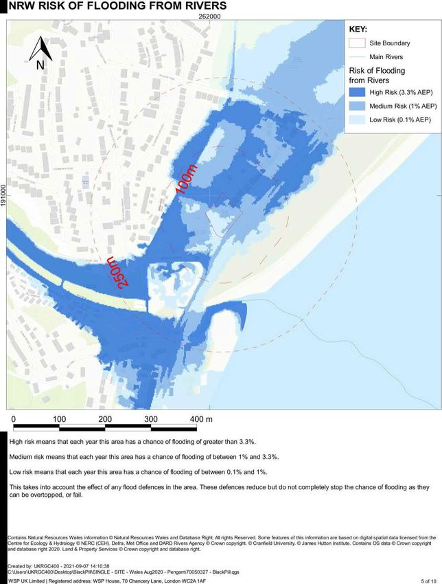
QUALITY CONTROL

 Issue/revision         First issue            Revision 1               Revision 2                Revision 3

 Remarks

 Date                   September 2021

 Prepared by            Richard Curtis

 Signature

 Checked by             Andrew Wilkinson

 Signature

 Authorised by          Andrew Wilkinson

 Signature

 Project number         7005-0327

 Report number          C01-00

 File reference         \\central data\Projects\700503xx\70050327 - MumblesRd DerwenFawr Swansea\03 WIP\03
                        Document\RP-01 - FCA

Black Pill, Mumbles                                                                         CONFIDENTIAL | WSP
Project No.: 70050327 | Our Ref No.: RP-C01-00                                                   September 2021
Lidl Great Britain Ltd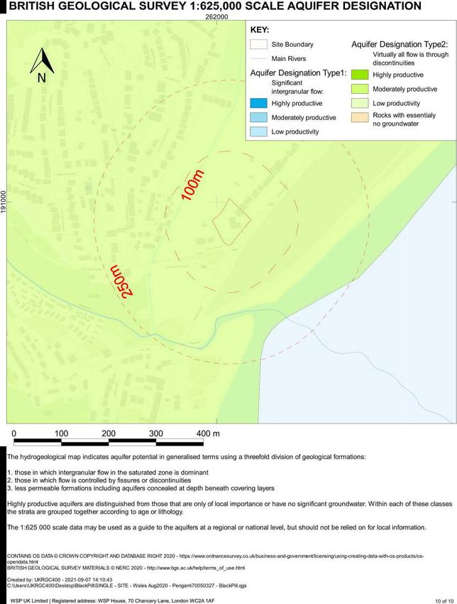
CONTENTS

Black Pill, Mumbles                              CONFIDENTIAL | WSP
Project No.: 70050327 | Our Ref No.: RP-C01-00        September 2021
Lidl Great Britain Ltd
TABLES
Table 2-1: Flood Event Probability Description                                      9

FIGURES
Figure 1-1: Site Location                                                           2
Figure 1-2: Proposed Layout                                                         3
Figure 2-1: NRW Development Advice Map                                              5
Figure 2-2: NRW Risk of Flooding from Rivers                                        6
Figure 2-3: NRW Risk of Flooding from the Sea                                       7
Figure 2-4: NRW Risk of Flooding from Surface Water & Small Watercourses            8
Figure 2-5: Preliminary Maximum Depths 1%cc AEP Proposed (cm)                      10
Figure 2-5: Preliminary Maximum Depths 0.1% AEP Proposed (cm)                      11

APPENDICES

TOPOGRAPHICAL SURVEY

PROPOSED DEVELOPMENT

FLOOD MAP PACK

Black Pill, Mumbles                                                CONFIDENTIAL | WSP
Project No.: 70050327 | Our Ref No.: RP-C01-00                          September 2021
Lidl Great Britain Ltd
Black Pill, Mumbles                              CONFIDENTIAL | WSP
Project No.: 70050327 | Our Ref No.: RP-C01-00        September 2021
Lidl Great Britain Ltd
1   INTRODUCTION
    WSP UK Ltd (WSP) were commissioned by Lidl Great Britain Ltd (the Client) to undertake a review of
    flood risk for a site in Black Pill, Mumbles Swansea. This Flood Consequences Assessment (FCA)
    has been undertaken with reference to Technical Advice Note 15 (TAN15) and is based on data sets
    provided by the client, Natural Resources Wales (NRW) and developed by WSP. The Construction
    Industry Research and Information Association (CIRIA) has defined a tiered three-level approach to
    flood risk assessment (C624) which will be used to identify the level of detail required for this FCA
    proportionate to the degree of flood risk. The three levels defined are as follows:
          Level 1 Screening study to identify whether there are any flooding issues related to a development
          site which may warrant further consideration;
          Level 2 Scoping study to be undertaken for each potential flood risk issue that is identified as being
          associated with a site during a Level 1 FCA. A Level 2 FCA involves a qualitative assessment of
          the flood risk to the site, and the impact of the site on flood risk elsewhere; and
          Level 3 Detailed study to be undertaken if the Level 2 study concludes that quantitative analysis is
          required to assess flood risk issues related to the development site.
    In the case of this site, a Level 3 study is considered sufficient to support a planning application.
    Following this introduction, the report first outlines the current understanding of flood risk in Section 2,
    followed by a discussion of sustainable drainage options in Section 3 before outlining the requirements
    of TAN15 in Section 4                                    ecommendations (S5) and conclusions (S6).

    The location of the site is illustrated in Figure 1-1 below1, located at Ordnance Survey National Grid
    Reference 262030, 190955 covering an area of approximately 0.4 hectares. The site is located in
    Black Pill, west of Swansea and contains a gravelled surface formally a garage / fuelling station. The

    situation includes the Cwm Stream flowing northeast to southwest some 70m west to the rear of the
    site, the Afon Clyne into which the Cwm stream flows some 280 m to the south of the site, beyond
    Mumbles Road is an extensive raised dune system which provides shelter to the site from the open
    coast of Swansea Bay some 150 m to the east. The site itself is generally flat at circa 6.7 m AOD in
    line with the Mumbles Road elevation, as can be seen in the topographic survey which has been
    provided in Appendix A.
    Published geological records (British Geological Survey Web Map Services2) indicate that the site is
    underlain by a superficial layer of raised storm beach deposits (sand & gravel) to the rear and blown
    sand to the front. The superficial layer is predominantly founded on the South Wales Lower Coal
    Measures (Mudstone, Siltstone & Sandstone) with a band in the south of the site of Hughes Member
    bedrock (Mudstone, Siltstone & Sandstone) and the soils would be expected to be a texture of Clayey
    Loam where associated with the Cwm Stream to the rear and Sandy where associated with the
    blown sand; however the records do show that between the dunes and the Cwm Stream is within an

    1
     Contains OS data © Crown copyright and database right (2021)
    https://www.ordnancesurvey.co.uk/business-and-government/licensing/using-creating-data-with-os-products/os-opendata.html
    2
        https://map.bgs.ac.uk/arcgis/services/BGS_Detailed_Geology/MapServer/WMSServer?

    Black Pill, Mumbles                                                                                    CONFIDENTIAL | WSP
    Project No.: 70050327 | Our Ref No.: RP-C01-00                                                              September 2021
    Lidl Great Britain Ltd                                                                                         Page 1 of 22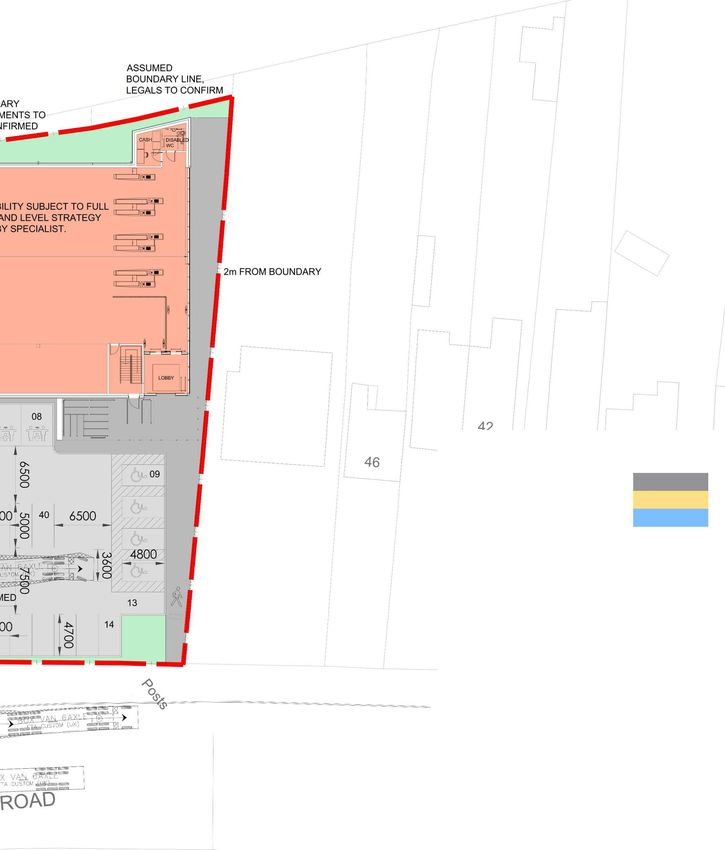
area of artificial landscaped ground (undivided) following the frontage over to the Brynmaill stream
and including the nearby hospital and university campus. A recent Remada report (Jan 2020)
reviewing the available SI & remediation reports note that pre demolition:

       (bgl) overlying sand to a maximum depth of 3.57m bgl resting upon peat and soft silt with
       organic material to a maximum recorded depth of 6.0m bgl. The bedrock geology was not
       encountered within the 6m depth of investigation. Groundwater was generally found to be
       resting at depths of between 0.74 and 2.06m bgl acr

                                                                                        Site Location

Figure 1-1: Site Location
(N.B. the garage shown on site in the mapping has since been demolished)

The proposals are to demolish one existing residence and construct a new retail unit (Lidl
supermarket) with parking and other associated infrastructure Figure 1-2 below provides an illustration
of these proposals which are also included in Appendix B.

Black Pill, Mumbles                                                              CONFIDENTIAL | WSP
Project No.: 70050327 | Our Ref No.: RP-C01-00                                        September 2021
Lidl Great Britain Ltd                                                                   Page 2 of 22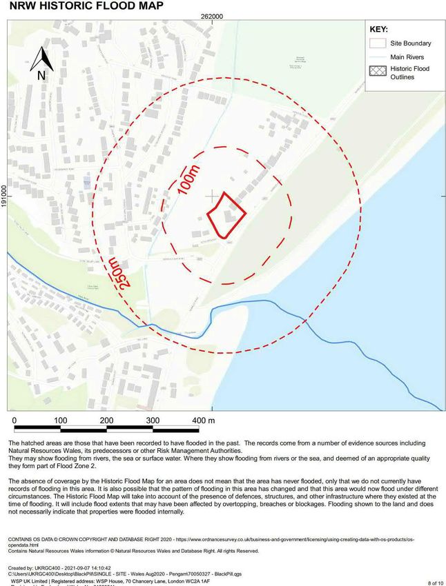
Figure 1-2: Proposed Layout

Black Pill, Mumbles                              CONFIDENTIAL | WSP
Project No.: 70050327 | Our Ref No.: RP-C01-00        September 2021
Lidl Great Britain Ltd                                   Page 3 of 22
2 EXISTING UNDERSTANDING OF FLOOD RISK
This section sets out the existing understanding of flood risk. The majority of the site is considered to
have a low risk of flooding; however, the northern corner currently has a high risk of fluvial flooding.
This section first considers the key online data (S 2.1) with a full set of maps provided in Appendix C,
followed by preliminary data generated by WSP (S2.2), then relevant local policy (S2.3 & S2.4) before
concluding with historic flood data (S2.5).
NRW provide a number of flood resources online, the following subsections sets out the data as they
are relevant to this site.
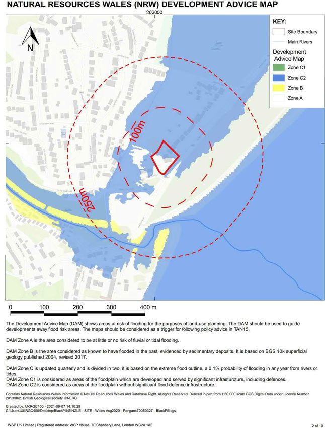
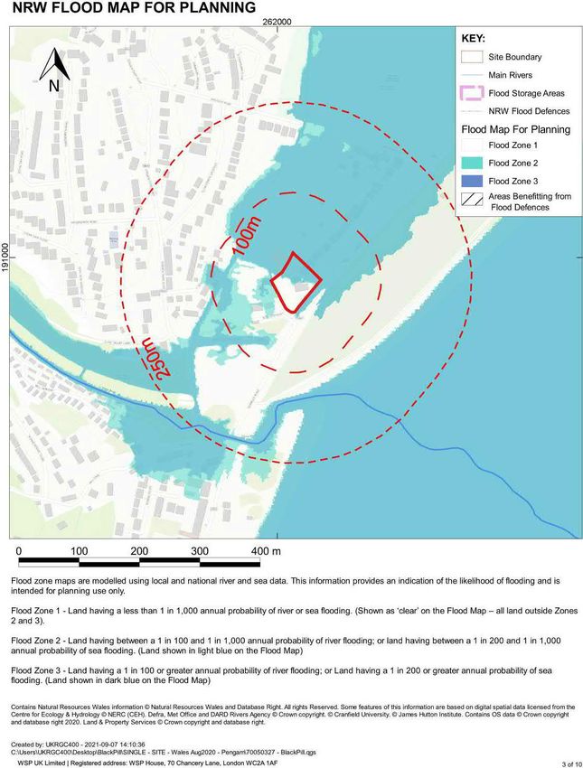
Developments such as supermarkets are classified as Less Vulnerable Developments in accordance
with Technical Advice Note 15 (TAN15). The Natural Resources Wales (NRW) flood maps show that
approximately half of the site is located within Development Advice Map (DAM) Zone C2 with the
remainder in Zone A. DAM Zone C2 is the area defined by NRW as being without significant
infrastructure, such as flood defences. According to TAN15, Less Vulnerable Developments may be
permissible in Zone C2, subject to the Justification Test and acceptability of consequences. DAM
Zone A is the area NRW consider as being at little or no risk of fluvial or tidal flooding and is generally
acceptable for all development types.
Black Pill, Mumbles CONFIDENTIAL | WSP
Project No.: 70050327 | Our Ref No.: RP-C01-00 September 2021
Lidl Great Britain Ltd Page 4 of 22Site Location
Zone C1: Served by significant infrastructure, including flood defences
Zone C2: Without significant flood defence infrastructure
Zone B: Areas known to have been flooded in the past
Zone A: Considered to be at little or no risk of fluvial or coastal/tidal flooding
Figure 2-1: NRW Development Advice Map
Black Pill, Mumbles CONFIDENTIAL | WSP
Project No.: 70050327 | Our Ref No.: RP-C01-00 September 2021
Lidl Great Britain Ltd Page 5 of 22Figure 2-2 below shows an extract from the NRW Risk of Flooding from Rivers map. The map shows
that the site is considered to be at a high risk of flooding in its northern corner. The remainder of the
site is considered to be at medium and low risk of flooding. Velocity vector plots suiggest that this is
from floodwaters overtopping the banks of the River Clyne and filling the hinterland behind the dunes.
Site Location
High Flood Risk from Rivers (3.3% AEP Extent)
Medium Flood Risk from Rivers (1% AEP Extent)
Low Flood Risk from Rivers (0.1% AEP Extent)
Main Rivers
Figure 2-2: NRW Risk of Flooding from Rivers
Black Pill, Mumbles CONFIDENTIAL | WSP
Project No.: 70050327 | Our Ref No.: RP-C01-00 September 2021
Lidl Great Britain Ltd Page 6 of 22Figure 2-3 below shows an extract from the NRW Risk of Flooding from the Sea map. The map shows
that the site is outside of the area considered to be at a low risk of flooding, i.e. is within an area which
NRW predict would flood with a probability of less than 0.1% in any given year.
Site Location
High Flood Risk from the Sea (3.3% AEP Extent)
Medium Flood Risk from the Sea (0.5% AEP Extent)
Low Flood Risk from the Sea (0.1% AEP Extent)
Figure 2-3: NRW Risk of Flooding from the Sea
Black Pill, Mumbles CONFIDENTIAL | WSP
Project No.: 70050327 | Our Ref No.: RP-C01-00 September 2021
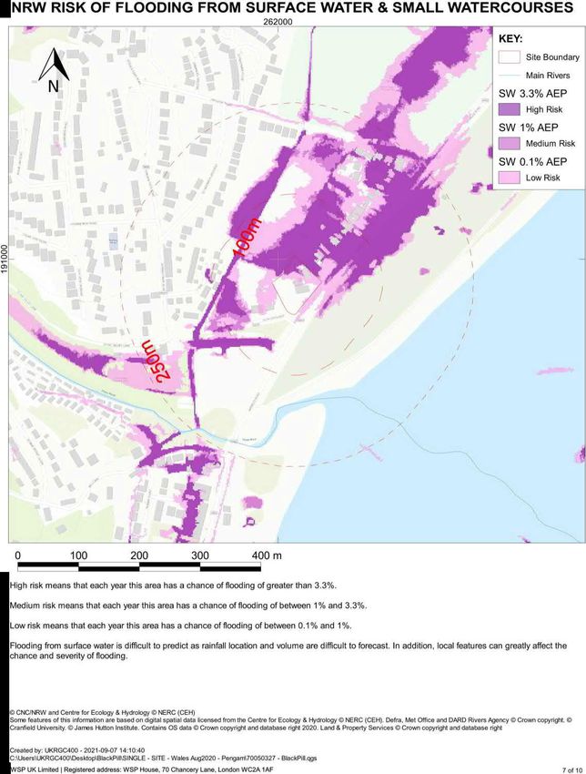
Lidl Great Britain Ltd Page 7 of 22Figure 2-4 below shows an extract from the NRW Risk of Flooding from Surface Water & Small
Watercourses map. The map shows that the site is predominantly outside of areas predicted to be at
risk of flooding from surface water and small watercourses, however a northern corner may be at risk
of flooding. A review of the vector plots associated with this map suggests that this floodwater is
predominately routing to the site from overtopping the Cwm Stream by the Swansea University Sports
Village, leaving the watercourse dry and routing over the King George V playing fields. As the stream
immediately downstream of this bend is dry in these results, it is likely that this assessment of risk is
overestimated.
Site Location
High Risk (3.3% AEP Extent)
Medium Risk (1% AEP Extent)
Low Risk (0.1% AEP Extent)
Figure 2-4: NRW Risk of Flooding from Surface Water & Small Watercourses
Black Pill, Mumbles CONFIDENTIAL | WSP
Project No.: 70050327 | Our Ref No.: RP-C01-00 September 2021
Lidl Great Britain Ltd Page 8 of 22WSP has licenced a 2009 HEC-Ras model from NRW and updated it so that it is fit for purpose when
using it to assess potential flooding at the proposed development site. The progression of this work is
described in a separate Hydraulic Modelling Report, however this FCA outlines the latest preliminary
findings. The model developed by WSP expresses Return Periods (RP) in terms of years, this is the
average anticipated interval between events of this magnitude or greater and corresponds to the more
intuitive AEP (Annual Exceedance Probability). The AEP percentage is the probability of an event of
this magnitude or greater occurring in any given year. The equivalence between the two methods of
describing the rarity of events is set out in Table 2-1 below.
Table 2-1: Flood Event Probability Description
Return Period
(1 in X Years)
AEP
(%)
The equivalence3 reported in the above table holds for return periods substantially greater than one
year.
When considering fluvial flooding there are two events which need particular consideration, the one
hundred-year event (1% AEP) with a climate change allowance (1%cc AEP) referred to as the key or
design fluvial event within this document and the one thousand-year event (0.1% AEP) referred to as
the extreme fluvial event within this document.
that the site starts to flood some 14 hours
after the start of the storm with a significant portion of the flows originating from the River Clyne
overtopping its banks where it passes under the disbanded railway and routing down Clyne Valley
Lane. Flood waters peak at circa 7.53 m AOD and 7.72 m AOD in the 1%cc and 0.1% events
respectively. This compares to current ground levels which range from circa 6.3 m AOD to 7.1 m AOD
but are generally around 6.7 m AOD.
In order to meet TAN15 requirements concerning the onset of flooding it is proposed that the building
footprint is raised to a minimum of 7.62 m AOD with the ancillary carparking area at a minimum of
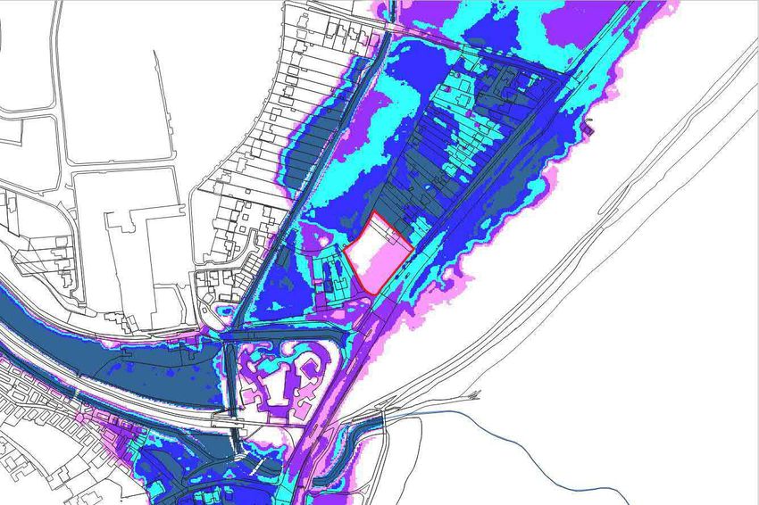
7.345 m AOD. Preliminary results from WSP model suggests that by changing the site topography to
these proposed elevations:
In the design event (1%cc) the proposed building is predicted to remain dry, with less than 20
cm of flooding on the carpark with a low flood hazard categorization and minimal offsite
impacts.
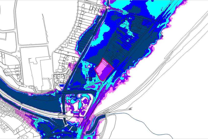
In the extreme event (0.1%) the proposed building is predicted to flood to circa 10 cm deep
with a low flood hazard classification, and the carpark to flood to less than 40 cm deep with a
moderate flood hazard classification, again this is predicted to result in minimal offsite impacts
3
The equivalence as reported in table should more accurately be
Black Pill, Mumbles CONFIDENTIAL | WSP
Project No.: 70050327 | Our Ref No.: RP-C01-00 September 2021
Lidl Great Britain Ltd Page 9 of 220 cm
0 cm
0 cm
0 cm
> 90 cm
Figure 2-5: Preliminary Maximum Depths 1%cc AEP Proposed (cm)
Black Pill, Mumbles CONFIDENTIAL | WSP
Project No.: 70050327 | Our Ref No.: RP-C01-00 September 2021
Lidl Great Britain Ltd Page 10 of 220 cm
0 cm
0 cm
0 cm
> 90 cm
Figure 2-6: Preliminary Maximum Depths 0.1% AEP Proposed (cm)
Black Pill, Mumbles CONFIDENTIAL | WSP
Project No.: 70050327 | Our Ref No.: RP-C01-00 September 2021
Lidl Great Britain Ltd Page 11 of 22Two Strategic Flood Consequences Assessments are available for Swansea, a Stage 1 SFCA and
Stage 2 SFCA. The Stage 1 SFCA4 is of particular note given the additional insight it provides
regarding the groundwater flood risk (S4.6). The Stage 2 SFCA5 considers specific development sites
none of which are in close proximity to the site of interest and thus unfortunately has no additional
information of interest for this FCA.
The relevant Shore
remain protected in the
foreseeable future; however, it should be noted that this is an intention of policy only and that there is
no guarantee this will not be altered by a future review nor that funding for this policy is assured.
y any flood records in this area. A search of the Chronology
of British Hydrological Events6
results. The lack of readily available recorded events does not necessarily show that the site has a
reduced risk of flooding.
4
Hoad G, Goodey P, Sweet R & Robinson J (September 2010) Stage 1 Strategic Flood Consequence Assessment City & County of
Swansea Council / Scott Wilson ref: D130737 - Final
5
URS (October 2012) Strategic Flood Consequence Assessment Stage 2 City and County of Swansea Council Ref: 47062124 - Final
6
http://www.cbhe.hydrology.org.uk/ [Accessed September 2021]
Black Pill, Mumbles CONFIDENTIAL | WSP
Project No.: 70050327 | Our Ref No.: RP-C01-00 September 2021
Lidl Great Britain Ltd Page 12 of 223 CONSIDERATION OF SUSTAINABLE DRAINAGE
Whilst this section summarises options for the drainage design, a separate drainage strategy has
been completed; therefore, further detail can be found in the separate report.
Runoff will be limited to as close to Greenfield rates as practicable, but this is not always achievable
especially at previously developed sites. In this case a betterment from the existing brownfield runoff
rates should be targeted as a minimum.
As part of the design process sustainable drainage methods have been considered and developed to
generally accord with the Statutory Standards for SuDS, which should thereby meet with the
satisfaction of the SuDS Approving Body (SAB). Given the presence of made ground beneath the site
and its potentially contaminated nature, the most preferable destination of the surface water discharge
hierarchy is to the Cwm Stream to the north of the site. The connection will be achieved via the existing
DCWW surface water sewer which runs through the southern corner of the site.
The SuDS hierarchy has been followed with consideration being given to the treatment train in order
to result in the runoff achieving a water quality that is satisfactory to the Local Authority.
Surface water runoff from the site is to be restricted to a maximum allowable rate of 5.1 litres per
second, which reflects greenfield conditions and when compared with the historical brownfield runoff
provides a 78% betterment against the 1 in 2 year return period event.
It is presumed that the site owner or the management company would be responsible for maintaining
the proposed drainage system. As the design of the drainage progresses, the requirements for
regular routine inspection and maintenance will need to be incorporated into the overall site operation
procedures in order to minimise the residual risks of flooding associated with surface water/sewers.
These should also consider the aftermath of a flood event on the system.
Continued regular inspection and maintenance of off-site adjacent watercourses, public / combined
sewers and highway drainage by NRW, DCWW and Swansea Council will be required to minimise
the risk of residual flood risks associated with off-site drainage infrastructure.
Appropriate pollution control measures will need to be included as the design progresses, in line with
the latest SuDS manual (C753) and best practice to the satisfaction of DCWW and Swansea Council.
Black Pill, Mumbles CONFIDENTIAL | WSP
Project No.: 70050327 | Our Ref No.: RP-C01-00 September 2021
Lidl Great Britain Ltd Page 13 of 224 REQUIREMENTS OF TECHNICAL ADVICE NOTE 15
This report assesses the suitability of the proposed development against the requirements of the
Technical Advice Note 15 (TAN15). This section outlines the risks identified in the report and explains
the steps required for the development to comply with current legislation.
According to the Development Advice Map the site is situated within both DAM Zone C2 and DAM
Zone A. The proposed development be
TAN15. According to Section 9 of TAN15 Less Vulnerable developments may be acceptable in DAM
Zone C2 subject to the Justification Test and the Acceptability Criteria. This report considers these
requirements in Section 4.10 below. All developments are generally permissible in DAM Zone A.
As the site has a residual risk of flooding, advice on the reduction of flood risk and flood consequence
has been provided for consideration. In particular the contents of the Environment Agency (EA)
7 8
should be
considered.
The site is located within the vicinity of the mouth of the River Clyne. Online flood maps suggest that
the majority of the site has a moderate fluvial flood risk. Preliminary modelling undertaken by WSP
suggests that flood waters peak at circa 7.53 m AOD and 7.72 m AOD in the 1%cc and 0.1% events
respectively. Therefore, by raising levels within the site from the current 6.3 m AOD to 7.1 m AOD but
generally 6.7 m AOD levels, a compliant development is theoretically possible as modelling suggests
minimal offsite effects.
The site is in proximity to the lower reaches of Cwm Stream. Online flood maps suggest the site may
be at risk of flooding from this source; however, it has been identified that these may overestimate this
risk as it shows waters wholly leaving the channel upstream from the site. Preliminary modelling
undertaken by WSP explicitly includes this source of risk but identifies the primary source of flood risk
as the Clyne River. The above proposals for raising site levels remain appropriate to mitigate this
source of risk.
A blockage on the River Clyne where it is crossed by the disbanded railway could force more water
onto the floodplain and result in a marginal increase in flood waters at the site. A blockage on the
Cwm Stream at either Derwen Fawr Road or Ashleigh Road would be unlikely to substantially alter
the flood risk to the site as flood waters would more probably overspill the road and regain the channel
rather than route through the site or resulting in significantly altered stage level.
7
https://www.gov.uk/government/publications/prepare-your-property-for-flooding - [Accessed February 2021]
8
Environment Agency, 2015. Prepare your business for flooding. Available at: https://www.gov.uk/government/publications/preparing-
your-business-for-flooding. [Accessed February 2021].
Black Pill, Mumbles CONFIDENTIAL | WSP
Project No.: 70050327 | Our Ref No.: RP-C01-00 September 2021
Lidl Great Britain Ltd Page 14 of 22The site, whilst near the frontage of Swansea Bay, is located behind a significant dune flood map suggests that the site has a negligible flood risk from this source. This risk would be further reduced by SMP policy to hold the line across all epochs as well as the proposed on site levels with the proposed finished floor level 7.62 m AOD being higher than the 0.1% tidal level predicted in 2096. As identified in Section 2.1 flood map identified the northern corner of the site as potentially being at risk from this source of flooding; however, the majority of this water is understood to originate from the Cwm Stream overtopping its banks adjacent to the Swansea University Sports Village, leaving the watercourse dry. As this watercourse is included within WS this source can be considered as sufficiently understood and mitigated by the proposed raised ground levels. Without a suitable drainage scheme, the proposal could increase runoff. It is recommended that a suitable Sustainable Drainage System (SuDS) scheme is implemented. Once a suitable drainage scheme has been approved by the LLFA and properly implemented this will satisfactorily address this aspect of flood risk. Current proposals show access/egress routes flooded in the extreme fluvial event and the extreme pluvial event. The pluvial flood depths may be an overestimate and are likely to be short duration during which time safe refuge may be a viable alternative. Preliminary results from W odel suggests egress from the site along Derwen Fawr Road exceeds descriptive guidance in TAN15 for depths from circa 14 hours into the simulation for approximately an 8 hour duration. The acceptability or otherwise of access and egress are the purview of the Local Authority as advised by NRW. It is possible, particularly given the managed nature of the proposed development, that the Local Authority may accept a policy of safe refuge or evacuation prior to a flood event, which can be predicted in advance, as supported by a Flood Action Plan (with the most appropriate route to/from the site). The site currently has a moderate risk of flooding; therefore, the development could displace flood water. Based on the proposed development and the suggested proposed ground levels (S4.1.1 & S4.2) there is the potential for flood waters to be displaced. Preliminary flood modelling undertaken by WSP does however suggest minimal displacement of flood water and therefore insignificant impacts to third party flood risk. Black Pill, Mumbles CONFIDENTIAL | WSP Project No.: 70050327 | Our Ref No.: RP-C01-00 September 2021 Lidl Great Britain Ltd Page 15 of 22
As noted in the Stage 1 SFCA:
                                                                                      greater risk in areas
            with significant Coal Measures that were previously mined. However, the majority of the former
            coal mining areas within the City and County of Swansea are believed to be fully recovered
            and therefore do not present a significant risk of flooding. Therefore, groundwater levels are
            not a significant flood ri
Available borehole data suggests that groundwater is struck circa 1 m below the ground and the
Groundwater Vulnerability Maps from BGS identify that the site is located on the boundary of both a
superficial & bedrock medium and high vulnerability area. Given the potential elevated risk of flooding
from groundwater it is recommended that the development includes neither sub-levels nor basements
without a suitable assessment of risk. The local groundwater level is likely significantly influenced by
the both of the two rivers into which groundwaters would preferentially route as well as the tidal level.
The drainage design should consider the potentially high groundwater level and consider how any
exceedance flows can be routed from areas of higher vulnerability. Groundwater tends to emerge
slowly and would typically follow drainage networks and flowpaths, thus is unlikely to pose an
emergency and the risk would remain limited once a suitable drainage design is in place.
Finally, it should be noted that the site is not located within a source protection zone as identified in
Appendix C.

The site is located on the edge of the area for which NRW issue flood alerts. Fluvial flood events can
be relatively short notice, however the River Clyde has a significant response time and therefore
                                                      . NRW should be contacted to ensure that their
warning coverage can be extended to include this site. The exact period of advance warning
notwithstanding, notice should be available prior to an extreme event and a Flood Action Plan can be
developed to manage safe refuge / evacuation and reoccupation. Awareness of flood risk can be
addressed within the Flood Action Plan and can include emergency notices posted next to fire notices,
inducting new employees and practice drills. Those responsible for the site should be encouraged to
                                   9
sign up to NRW                       (0345 988 1188).

                                                                          not predicted to be at risk of
flooding from a reservoir failure. A review of freely available map data identifies no significant ponds
or lakes within the Clyne River catchment and there are no known active canals in the vicinity. Neither
the Cwm Stream nor Clyne River are considered navigable waterbodies. Sizable vessels could
navigate Swansea Bay and, whilst not a regular occurrence, adverse weather could drive vessels into

9
    https://naturalresources.wales/flooding/sign-up-to-receive-flood-warnings/?lang=en

Black Pill, Mumbles                                                                      CONFIDENTIAL | WSP
Project No.: 70050327 | Our Ref No.: RP-C01-00                                                September 2021
Lidl Great Britain Ltd                                                                          Page 16 of 22
the dune system; however, this is unlikely to result in a breach and proposed site levels are identified
as being above maximum tidal levels, thus the level of risk would be unlikely to be significantly altered.
Having considered the flood risk from lakes, reservoirs and canals, two principal infrastructure sources
remain: a burst water main and the sewerage networks. A burst water main would likely have a similar
effect as a sizable rainfall event and can be mitigated by the raised site levels and the drainage design.
Similarly, a surcharging sewer would likely follow a similar exceedance flowpath which the drainage
design should identify as external to areas of higher vulnerability. Therefore, once the drainage
strategy has been agreed with both the SAB and sewerage undertaker the risk of flooding from this
source can be considered as residual and should not forestall development.
The current version of TAN15, is due to be superseded in 2021. The revised guidance on flood risk is
understood to follow a more risk based approach. It is considered that the main findings of this report
are likely to remain relevant under the new guidance, however until the update is released we cannot
be sure of its content.
This subsection of the report outlines and discusses the Justification Test, Acceptability of
Consequences and Development Advice as set out in TAN15.
Section 6 of TAN15 outlines the Justification Test, it states:
that:
i. Its location in zone C is necessary to assist, or be part of, a local authority regeneration
initiative or a local authority strategy required to sustain an existing settlement; or,
ii. Its location in zone C is necessary to contribute to key employment objectives supported by
the local authority, and other key partners, to sustain an existing settlement or region.
And:
iii. It concurs with the aims of PPW and meets the definition of previously developed land (PPW
fig 4.1); and,
iv. The potential consequences of a flooding event for the particular type of development have
been considered, and in terms of the criteria contained in sections 5 and 7 and appendix 1
Given the site s location on a vacant/remediated infill site, the proposal meets the requirements of
point ii, this case will be further supported in the full application by supporting documentation setting
out the argument for a new retail development at this location. The site is an erstwhile garage / fuelling
station and so also meets point iii of the Justification Test. This report considers the flood
consequences in terms of the relevant criteria and when supported by the Hydraulic Modelling
provides sufficient information to assess whether those consequences are acceptable as per point iv.
Black Pill, Mumbles CONFIDENTIAL | WSP
Project No.: 70050327 | Our Ref No.: RP-C01-00 September 2021
Lidl Great Britain Ltd Page 17 of 22In this case, this report considers that the proposed development is likely to pass the Justification
Test.
Section 7 of TAN15 outlines the acceptability of consequences particularly within 7.2 and 7.3:
Under Section 7.2 of TAN15 the three key criteria of acceptability are whether:
1. the consequence of flooding can be managed down to an acceptable level,
2. safe access can be achieved, and
3. timely flood warnings can be provided.
This report and the Hydraulic Modelling Report will provide sufficient information on flood depths,
access and flood warnings for these acceptability criteria to be understood.
Section 7.3 of TAN15 notes that if a development is justified, mitigation measures should be
incorporated into the design to make it as safe as possible and that there is:
Minimal risk to life;
Minimal disruption to people living and working in the area;
Minimal potential damage to property;
Minimal impact of the proposed development on flood risk generally, and;
Minimal disruption to natural heritage.
This report sets out the risks as currently understood and makes a number of recommendations in
Section 5 below to mitigate this risk.
Further criteria describing the acceptability of flood consequences are set out in Appendix 1 of TAN15.
Whilst there is some overlap with the above these have been summarised below for completeness.
A1.3 The mechanisms likely to cause flooding must first be fully understood.
A1.4 It is important that uncertainties are acknowledged and taken into account.
A1.5 A proposed development must provide a safe living / working environment throughout its life. Those
living/working on the site must, as far as is practical, have an appreciation of the dangers.
A1.6 During extreme flood events the landscape may physically change. Consideration should be given to
the possibility of flooding caused by blockages. This may well require modelling failures or breaches in
defences to consider the effect of this situation.
A1.7 The adequacy of existing flood defences must be carefully considered under a range of flood conditions,
particularly those which cause overtopping of the defences. Where breach scenarios exist consideration
should be given to the adoption of a suitably sized buffer zone within which no development should be
allowed.
A1.8 Measures taken to ensure flood consequences are managed to acceptable levels must be indicated and
planning conditions or a S106 should be applied to require implementation.
A1.9 Particular attention should be given to the impact of the development on flood risk elsewhere on the
flood plain. It may not always be possible to manage these dangers.
A1.10 Assessment must be undertaken by a suitably qualified person carrying an appropriate Professional
indemnity.
A1.11 New development on the flood plain will generally result in additional risks. NRW will advise the LA on
their acceptability.
A1.12 To satisfy these criteria a site should only be considered for development if the following conditions can
be satisfied:
Flood defences must structurally adequate.
The cost of future maintenance for mitigation must be agreed with the Environment Agency [sic].
The developer must ensure that future occupiers are aware of flood risks and consequences.
Effective flood warnings are provided at the site.
Access routes are operational under all conditions.
Flood emergency plans and procedures produced by the developer must be in place.
The development allows the occupier to rapidly move possessions away from floodwaters.
Black Pill, Mumbles CONFIDENTIAL | WSP
Project No.: 70050327 | Our Ref No.: RP-C01-00 September 2021
Lidl Great Britain Ltd Page 18 of 22The development is designed to minimise structural damage and is flood proofed to facilitate
reoccupation.
No flooding elsewhere.
A1.13 NRW will advise the Local Authority whether the above criteria have been satisfied.
A1.14 Commercial developments should be flood free in the 100 year fluvial event (1%) as well as the 200
year tidal event (0.5%).
A1.15 Where flooding occurs in the extreme event (0.1%) indicative figures have been provided as to what
may be considered acceptable (N.B. These values are descriptive not prescriptive).
Maximum flood depth (property/access) 600 mm
Maximum rate of rise 0.3 m/hr
Maximum speed of inundation 2 hours
Maximum velocity of floodwaters 0.15 / 0.3 m/s (property/access)
A1.16 Local Authorities should require that developments in flood zones incorporate physical features to
highlight the risk.
This report, which is supported by Hydraulic Modelling provides sufficient information for these
acceptability criteria to be addressed. The acceptability criteria are arguably met in the majority of
cases noting that:
Details concerning flooding and flood mechanisms are set out within this report and the Hydraulic
Modelling Report.
Assessing the adequacy of current defences (none identified in available map data) is beyond the
scope of this report and a matter on which NRW will advise.
The descriptive values of acceptable flooding in the extreme event will likely be m
location and via the proposed ground raising; however, whilst the depth criterion can be readily
assessed based on the available data, the remaining criteria would require additional investigation
to fully determine.
Access and egress may not be operational under all conditions, however safe refuge and
evacuation in accordance with a Flood Action Plan are suggested as viable alternatives.
Recommendations set out in Section 5 will improve compliance with the acceptability criteria.
For Less Vulnerable developments in DAM Zone C2 the development advice according to Section 9
is that:
or applications for less vulnerable development can only proceed subject to
justification in accordance with section 6 and acceptability of consequences in accordance
Black Pill, Mumbles CONFIDENTIAL | WSP
Project No.: 70050327 | Our Ref No.: RP-C01-00 September 2021
Lidl Great Britain Ltd Page 19 of 225 RECOMMENDATIONS
This section of the report outlines the recommendations, noting that some are for consideration to
further reduce flood risk and consequences whilst others should be undertaken to ensure compliance.
Finished floor levels should be raised such that they remain dry in the design event (1%ccAEP)
and such that the maximum predicted depths in the extreme (0.1%AEP) event are under 600 mm.
This level, which has been informed by preliminary hydraulic modelling outputs, is to be 7.62 m
AOD.
In addition to raised floor levels, raised ground levels should also be included to mitigate against
excessive depths in the ancillary parking area. This level, which has been informed by preliminary
hydraulic model outputs, is to be a minimum of 7.35 m AOD.
Preliminary modelling undertake by WSP suggests that the proposed ground raising is unlikely to
displace significant volumes of water and in this case that offsite impacts are minimal.
Mitigation measures over and above the raised FFL should be considered to reduce both the risk
and the impact of flooding, with passive measures considered preferentially over active measures.
Additional measures could include but are not be limited to:
Flood-proof doors or inbuilt demountable defence attachment/anchor points,
Ventilation should be sealable or self-sealing up to the extreme event plus freeboard,
Non-return valves fitted to drains and water in/outlet pipes as appropriate,
Ground floor walls dry lined using lime based plaster and draining cavities as appropriate,
Ground floors to be tiled / hard flooring as opposed to fitted carpets,
Ground floors to include raised electrical sockets,
Any parking areas to be designed to passively accommodate flood waters,
Sensitive equipment kept at an elevated level.
A Site specific Flood Action Plan should be developed. This should include clear responsibilities
and chain of command including procedures for confirming actions and coping with absences. It
should give due consideration to evacuation and safe reoccupation. It is suggested that warning
notices should describe flood the risk and any flood access constraints.
The proposals should consider the possibility of including internally accessible safe refuge (dry in
the extreme event) area(s) to which those on the ground floor can retire to in the event of a no-
notice flood event. Ideally this safe refuge should be set above the extreme flood level with
freeboard (300 mm) over the lifespan of this development, i.e. above circa 7.76 m AOD.
NRW should be contacted to ensure that their flood alert area is expanded to cover the site and
anyone responsible for the site, the business(es) or employees should be encouraged to sign up
to flood warnings direct.
Vulnerable equipment should be preferentially set above the extreme flood level with a freeboard
allowance.
A drainage design should be developed with the aim of ensuring there is no significant increase in
surface water runoff and the risks of flooding due to localised runoff or exceedance flowpaths are
minimised.
The development should be of a less vulnerable classification i.e. offices, retail and general
employment.
It is recommended that basements or sub-levels are neither incorporated into the design nor added
at a later date and that the site is not used for overnight accommodation, emergency services,
Black Pill, Mumbles CONFIDENTIAL | WSP
Project No.: 70050327 | Our Ref No.: RP-C01-00 September 2021
Lidl Great Britain Ltd Page 20 of 22waste disposal, for storing of processing hazardous materials or for other more vulnerable uses even on a temporary basis without an approved FCA specifically considering such changes. The structural and façade design of the building should suitably account for the predicted depths external to the building footprint. It is recommended that the proposal incorporates physical features to highlight the risk of flooding as per TAN15 (A1.16). Black Pill, Mumbles CONFIDENTIAL | WSP Project No.: 70050327 | Our Ref No.: RP-C01-00 September 2021 Lidl Great Britain Ltd Page 21 of 22
6   CONCLUSIONS
    The site contains a significant portion of DAM Zone C2, Less Vulnerable Developments such as retail
    may be permissible in DAM Zone C2, subject to the acceptability of consequences, the Justification
    Test and surface water drainage requirements. Although the site is considered to be at a low risk of
    flooding from most sources, a risk of fluvial flooding has been identified. The current ground levels on
    the site, being lower than the design flood level, require raising in order to comply with TAN15
    requirements. Raising the Finished Floor Levels (FFL) and including additional mitigative measures
    as set out in the recommendations would improve compliance with TAN15; however, some aspects
    such as access/egress may not fully comply with guidance under all conditions. It should be noted
    that the acceptability of the access/egress arrangement is a matter for the Local Authority and can be
    managed through an Emergency Flood Plan.

    Black Pill, Mumbles                                                              CONFIDENTIAL | WSP
    Project No.: 70050327 | Our Ref No.: RP-C01-00                                        September 2021
    Lidl Great Britain Ltd                                                                  Page 22 of 22
CONFIDENTIAL
CONFIDENTIAL
CONFIDENTIAL
1 Capital Quarter
Tyndall Street
Cardiff
CF10 4BZ

wsp.com

                    CONFIDENTIAL
You can also read