Leixlip - Local Area Plan 2020-2026 Submission by Catherine Murphy TD - Kildare.ie
←
→
Page content transcription
If your browser does not render page correctly, please read the page content below
Leixlip - Local Area Plan 2020-2026
Submission by Catherine Murphy TD
The core strategy contained within the Kildare County Development Plan 2017-2023
allocated one third of Kildare’s housing growth to Celbridge, Leixlip, Maynooth and Kilcock
with the latter designated to accommodate 5% and each of the other three designated to
accommodate 10%. At that time the underpinning plan was the National Spatial Strategy this
has now been superseded by the National Planning Framework (NPF). The NPF was
published in February 2018 in tandem with the National Development Plan (NDP).
The NPF sought to prioritize growth in the cities of Dublin, Cork, Limerick, Galway and
Waterford with one of its aims to achieve compact growth and balance regional
development. The publication of the NPF and NDP together was aimed to achieve a degree
of certainty around the delivery of infrastructure alongside housing and industrial
development, this is to be welcomed.
Despite the change in focus contained in the NPF the settlement strategy for Kildare
confirmed Leixlip’s position within the Dublin Metropolitan Area, largely on the basis of its
proximity to the Maynooth Railway Line and the presence of two Railway Stations; Louisa
Bridge and Confey. It is curious that no revision to the Kildare County Development Plan
settlement strategy took place following the adoption of the NPF/NDP it does pose the
question as to what guarantees there are for associated infrastructure and services should such
large scale development take place.
The allocation to Leixlip of 10% growth and the provision of 3315 new housing units is a
huge challenge not least because of the very significant constraints which include; County
Boundaries with Fingal; Meath and South Dublin – the presence of the River Liffey and the
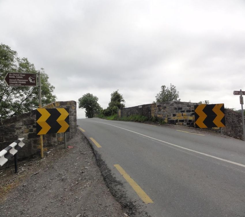
River Rye together with the Royal Canal – The M4 motorway – St Catherine’s Park and the
Liffey Valley itself. The topography of the area which means the village itself is in a valley.
It does appear the 10% was initially a paper exercise without really considering how
developing this number of housing units could be achieved.
The most recent census of population recorded 5524 households in Leixlip and also recorded
a population 15,504. As can be seen in the table below the housing stock that produced
the population growth occurred over several decades. This current Local Area Plan provides
for up to 60% growth over a ten year period, some of which is in locations with severe
infrastructural deficits that will be difficult and expensive to overcome and some substantially
dis-improve the quality of life for existing residents.
POPULATION

1971    1981     1986      1991      1996     2002      2006   2011   2016
2,402   9,306    11,938    13,194    13,451   15,143    14,676 15,452 15,452

The plan proposes significant rezoning for housing development with the objective to
accommodate an additional population of 4252 bringing the population of Leixlip up to
19,794. It is stated in the Leixlip LAP that the rate of occupancy as shown by CSO in the
2016 Census is 2.78 and acknowledges that this is higher than forecast. This means that the
quantum of land identified as needed, together with the existing population, could in fact
accommodate in excess of 24,000.

The Central Statistics Office projects a population increase in the Mid East Region of
between 78,000 and 144,000 by 2031. In its settlement strategy Kildare has provided for
32497 new housing units should the occupancy rate of 2.78 continue that could result in a
new population in excess of 90,000 well before 2031. While not all land zoned for housing
will be developed and some over-zoning is required, the extent of the lands earmarked for
development seems excessive. Given the actual occupancy rates as captured in the 2016
Census were underestimated it would seem obvious that reducing the target population and
amending the occupancy rates for Kildare to reflect actual numbers is essential, this would
require an amendment to the County Development Plan.

Key Features of the Leixlip LAP
Four Key Development Area’s KDA’s together with an Urban Design Framework have been
earmarked as the primary area’s to accommodate more than 3300 new homes within
the Leixlip Local Area Plan (LAP). With a further 60 hectares of land designated in the
Collinstown area for strategic employment within a Business Campus.

KDA1 – The Wonderful Barn area is an active site with planning permission for 450 housing
units.

KDA2 – Leixlip Demesne 355 housing units are proposed here. Vehicular access is from the
Celbridge Road.

KDA3 – Leixlip Gate 323 houses are proposed here with vehicular access from Easton Road.
There are low density housing located here and the plan envisages that “intensification or
redevelopment of these properties may occur during the lifetime of the plan”

KDA4 – Black Avenue/Glendale Meadows – 350 new housing units with vehicular access
from the Black Avenue.

UDF – Confey – 1340 residential units are proposed in the Confey area over Cope Bridge
vehicular access is proposed via an upgraded L1015 together with a new link road provided
along the northern extremities of the land.
Collinstown - Almost 60 hectares have been designated for strategic employment within a
Business Campus – Intel is also located in the Collinstown Area and has current planning
permissions for a major expansion.

KDA1 - The Wonderful Barn

The Wonderful Barn area is an active site with planning permission for 450 housing units.
Construction has commenced recently and includes an alteration to the entrance to the site.

This site also includes a public park, part of which is successfully used for allotments. The
Wonderful Barn has the potential to be developed as a visitor centre or similar community
use which would require some public parking and other facilities, the location for these
facilities needs to be identified and provided for in the plan.

The Wonderful barn is a structure unique to Kildare, it is a listed building and is of historical,
archaeological and cultural significance, in particular its relationships with Castletown and
the surrounding landscape. The Leixlip Town Plan should contain objectives to develop a
conservation and management plan for the entire Wonderful Barn site. This should inform
any future uses for the site in keeping with best practice. Activities permitted should be in
accordance with this plan. A bridge link between the Wonderful Barn Lands and Castletown
Demesne should be included as an objective.

Access & Traffic issues

The Celbridge Road is a single carriageway that currently provides access to the following
housing     estates;      Elton      Court,    Forest     Park,     Castletown,     Leixlip
Park, Wogansfield, Highfield Park, Knockaulin, totalling well in excess of 1000 houses.
Colaiste Chiaráin (Secondary) and Scoil Ui Dhalaigh (Primary) schools are also located on
the Celbridge Road. A busy neighbourhood shopping centre is also situated at the entrance
to Castletown Estate with a smaller commercial area beside Colaiste Chiaráin.

The central spine road through Castletown Housing Estate was not designed as a distributor
road but is increasingly used for that purpose, with the development of 450 new housing
units in the vicinity of The Wonderful Barn and perhaps further development at Leixlip
Demesne, even greater pressure will be applied to this area making it less safe/ attractive for
cyclists or pedestrians. These issues need to be specifically addressed in the context of a
sustainable movement strategy and cannot be seen as site specific.

In addition the former Hewlett Packard Campus; Barnhall Rugby Club; Salmon Leap Canoe
Club together with the community of Coneyboro are to the west of the proposed
development. The proposed access to the Leixlip Demesne lands are also earmarked for new
residential in excess of 350 units; the parklands around the Wonderful Barn together with the
new housing will generate additional movements. All of the above need to be collectively
considered in the context of achieving a sustainable pattern of movements across all modes.
While it is desirable for people to walk or cycle congestion results in this being risky
particularly for more vulnerable road users.

Dublin Bus provide a limited service to the Celbridge Road, the 66B terminates at the Salmon
Leap Canoe Club. The junction with Maynooth Road, which is not controlled with
lights, is under significant pressure with several peaks’ during the day such as school
opening and closing times and shift changeover at local industries, together with the normal
morning and evening peak’s... Bus Connects proposals will not be evident until September
but require specific consideration including location of bus stops.
KDA2 - Celbridge Road (Leixlip Demesne)
New Residential – Proposed new Zoning for approx. 355 houses with parkland also
proposed in this location. Vehicular access would be from Celbridge Road opposite to the
Wonderful Barn site. Should the two developments proceed, each with just one vehicular
entry/exit point, this would produce more than 700 houses sharing one junction on a road
that is already extremely busy, it is essential that the totality of what is proposed together
with existing infrastructure and potential for improvements is considered in tandem.
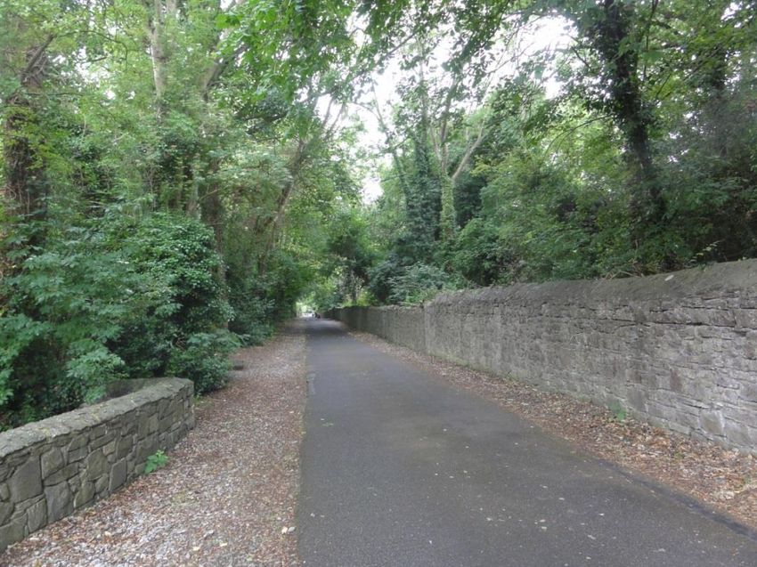
There are two cycle/pedestrian entrance/exits at Leixlip Park and Wogansfield. It would
seem that cycle facilities could be designed within the proposed new development but would
terminate at the boundary. No serious consideration seems to be given to the impact on
Wogansfield and Leixlip Park of this traffic. Wogansfield can be seen in photos below the
first one is towards the settlement from Celbridge Road. The second view is from the
settlement it shows the neighbourhood shops behind which is the secondary school it would
be expected that considerable pedestrian traffic would need to be accommodated. There is no
room here for a footpath.
Towards Wogansfield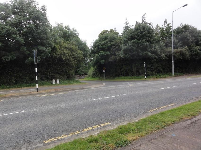
From Wogansfield

Leixlip Castle
“Historically, the center of Leixlip has always been Leixlip Castle. Built on a rock at the
confluence of the River Liffey and the Rye Water were granted to the de Hereford family and
dates from the Norman Invasion of 1171 with the round tower added onto the square keep in
the 14th Century. The castle was strategically placed at the confluence of the River Liffey and
the River Rye. Over the following several hundred years Leixlip Castle was to be one of the
strongholds of the Pale - an outpost.

In 1732 the castle was acquired by William Conolly, nephew of Speaker William Conolly,
who inherited Castletown House, the lands of which adjoin the Leixlip demesne to the west. “
(text from Leixlip Town Council Website)
Leixlip Castle/Demesne
Both Leixlip Castle and Demesne are listed as protected in the LAP page 66/67. While parts
of these lands were separated in the context of the construction of the M4 what remains
requires to be protected. Should this land be rezoned for housing it will undermine Leixlip
Castle/Demesne as the Historic Centre of Leixlip. The Demesne Lands are listed as
protected in the LAP which conflicts with the proposed rezoning. The Demesne wall runs to
the rear of Leixlip Park and Wogansfield which indicates the boundary of the Demesne.

The protection of all structures and the immediate surroundings including the curtilage and
attendant grounds of structures contained in the Record of Protected Structures is covered by
Policy BH1 on page 68. The development of a housing estate within its boundaries
significantly reduces the lands adjoining the Castle.

To see the Castle in Context it is essential to also look at the South Dublin County Boundary
and the presence of Fingal’s Water Works as it relates to Leixlip Castle and Demesne. The
photo above shows its proximity to the east of the Castle. Protecting what remains of the
Demesne is essential to ensure the Castle can be seen in its natural context. Constructing a
large modern housing estate to the west of the Castle further erodes the context of the Castle.
This demonstrates how difficult it is to find suitable locations in Leixlip to comply with the
core strategy of the County Plan which forces a conflict with other objectives because of the
lack of available suitable land for housing development.

For the reasons stated above KDA2 should be removed from the Local Area Plan.

KDA3 – Leixlip Gate

It is difficult to see how the lands in question can accommodate the proposed 323 houses
proposed for this location. The previous draft earmarked this location for 200 residential
units. This location currently accommodates low density housing.           The Plan states
“intensification or redevelopment of these properties may occur during the lifetime of the
plan”. Most of those living within this established community have been there for several
decades it is impossible to imagine how such intensification could occur in unison and if it
occurs at all is likely to happen in a piecemeal way either voluntarily or perhaps under
pressure from new higher density developments.

The existing entrance/exit is from Easton Road is very deficient and would require significant
improvement, how would that occur should development be piecemeal? It is also not
earmarked in the plan for junction improvement. Easton Road was constructed in recent
years and is heavily trafficked, traffic calming measures have been installed as a
consequence of safety concerns such large scale development would also produce a need for
further safety amendments.
Leixlip Gate entrance together with mature trees.

Existing narrow entrance to Leixlip Gate from Eason Road
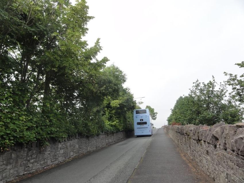
KDA4 – Black Avenue/Glendale Meadows

Residential Development– 350 new housing units with vehicular access from the Black
Avenue.

The map below dates from 1810 and shows the bridge over the River Liffey which links
Kildare with Dublin to the right Mill Lane is visible and it has changed very little as can be
seen in the photo below. The entrance to St Catherine’s park is identified and is known as
Black Avenue this avenue leads into the park and also to Kildare’s Waste Water Treatment
Plant. The plant attracts large volumes of HGV’s which conflicts with those who walk to the
park. At the end of the avenue a car park was constructed to serve the parklands, it is the
only vehicular access to the park on the Kildare side.
Mill Lane facing towards Main Street

The entrance to Black Avenue Mature Trees on embankment to the left the
entrance is earmarked for junction “improvement”
Black Avenue - embankment to the left - 15kmp speed limit – traffic
                signals and steep incline can be seen

Black Avenue – towards the Car Park –new road objective included in
                               LAP
Proposed new Housing Estate overlooks Waste Water Works The LAP states that this KDA provides a significant opportunity to provide a green and safe new access for pedestrian/cyclist and vehicular traffic to St. Catherine’s Park and the existing car park while also facilitating residential development which respects the setting of the subject lands and provides passive surveillance of the adjoining parklands. Achieving the safe new access cannot be done without felling the trees the LAP seeks to protect. The land the trees are located on is on a steep incline so the levels do not easily facilitate what is proposed. The entrance is restricted to a single carriageway with buildings preventing the widening of the access. The area towards the car park is bounded on one side by a wall behind which are mature trees which are located on an escarpment. Again this shows the limits of the land available for housing in Leixlip it is impossible to imagine how this can be justified on planning grounds and it should accordingly be omitted from the plan. UDF – Confey – 1340 residential units 1340 residential units are proposed in the Confey area over Cope Bridge. Vehicular access is proposed via an upgraded L1015 together with a new link road provided along the northern extremities of the land. While it is very welcome that access is no longer envisaged through St Catherine’s Park, the plan needs to specifically state this and reinforce the value and importance of the Park. A commitment to interact with Fingal and South Dublin Councils to remove the “indicative road line” also needs to happen without delay.
Lands included because of their proximity to Confey Railway Station
The proximity to Confey Railway Station and the plans for the electrification of the line is the
context for including this land in the LAP. The electrification of the line will require
significant alteration to several bridges including Cope Bridge which will be very disruptive.
One way traffic is currently controlled over the bridge using traffic signals.

Cope Bridge – single carriageway controlled by traffic signals – footpath to
            the right leads to Confey GAA and subject lands.

According to the plan it is not intended to permit the proposed development in advance of
this work taking place. The upgrade of the L1015 which is a narrow winding road with
some houses fronting on to it, connects Kildare with Fingal is expected to be the primary
vehicular route on the Fingal side of the proposed development. A key question will be
Fingal’s plans for the Mount Thunder area and plans for road and bridge improvements
which would be necessary to accommodate traffic this is likely to occur in the context of
electrification of the Maynooth Line. In the absence of road upgrade and bridge
improvements at this location further pressure would be put on Captain’s Hill which is
already at saturation point at peak times. There is also no room to widen the Captains Hill.

The proposed alternative route to this site from Dublin is through the already heavily
congested Lucan Village- across the Liffey towards Laraghcon beyond which the road
deteriorates, the bridge below spans the railway and canal. The cost of such upgrades needs
to be considered together with the identification of finance to deliver such improvements.

It seems to me that the traffic congestion already evident in Lucan has not been considered in
the context of this plan. It is possible to imagine post the Confey development questions
being asked like, Where were the planners?
Bridge over Canal leading to Lucan –
Proposed alternative route to Captains Hill
Captains Hill – Cope Bridge
The most direct route to this location is by way of Captain’s Hill which serves the existing
housing estates. Combined these estates total in excess of 1500 homes, a busy
neighbourhood centre; two primary and one secondary school; Leixlip Cemetery and
Confey GAA club both of which are part of the subject lands. In the absence of an attractive
alternative it is difficult to see why new residents in this area would not use the most direct
albeit congested route. There are already issues with resident having difficulty exiting their
estates at peak times in particular.
The doubling of the track and improved services on the Maynooth Line have occurred in
recent years, these had been sought and are well used by the community. At peak times the
services are so heavily used that it is standing room only. Refurbished railway carriages are
on order, when they arrive in 2020 they will need to be commissioned before going into use
hopefully this should deal with the current deficiency. New rolling stock, including for the
electrification of the line is planned, from the date of order, which has not happened yet, a
lead in time of five years is envisioned, enhanced services on the electrified line will post
date the delivery of this rolling stock. Any phasing proposals must to consider this.
Parking at Confey Railway Station
The absence of adequate car parking at Confey Station results in all day parking in the
housing estates adjacent to the station. This deficiency must be catered for in the plan as
should the provision of bicycle parking and facilities. While it is desirable that those using
trains arrive on foot or cycle that is not always possible and needs to be provided for. TheUDF states ‘Bike Parking Infrastructure Guidance’ prepared by the Dublin Cycling
Campaign 2017 should be used a reference guide in providing such infrastructure within the
Framework lands.” This is to be welcomed but again consideration needs to be given to how
this can be applied to the existing area and should be specified in the LAP.
Current Parking is limited at Confey Railway Station
Confey GAA
Confey GAA is designated in the UDF for mixed use. The Clubhouse and playing fields
were purchased and developed/constructed by Confey residents and are well used. They are
already a considerable distance from parts of Confey such as Riverdale; Glendale Meadows
and Woodside the relocation of those lands will be of benefit to the planned new community
but will work to the disadvantage of the existing community and will inevitably produce new
vehicular movements. It is notable that the LAP measures distances from the Railway
Station from within the proposed new development however, it does not measure distances
for relocated and more inaccessible facilities for the existing community. The vision for the
new neighbourhood is to maximise the use of sustainable modes of transport which in itself is
to be welcomed however it does appear to take a silo approach to these lands and lacks an
understanding of how that links with the existing communities or to the Fingal area.Confey GAA grounds as seen from Cope Bridge – Proposed for Mixed Use
Riverforest Park
Bridge and proposed Strategic Pedestrian & Cycle Route
The proposed location for the bridge at Riverforest Park linking the greenway is curious to
say the least. It is impossible to imagine how this would work in reality and I wonder if this
was mapped without actually visiting the area. While the greenway is an excellent use of the
tow path and there is a value in access being gained from several locations what is currently
proposed is simply not workable. Huge efforts by the Riverforest Residents Association were
made to make this park usable it is essential that KCC Planning Department engage with the
Association should this link be adopted. Please note the trees in the distance see next photo.View from Top end of Park as shown above.
The bridge is proposed here - Railway Line and Canal to the rear.
The path and cycle way is proposed through the centre of the green.
St Catherine’s Park
The park has been used to accommodate major pipe infrastructure in the recent past with
further developments of that nature planned in the near future. There was poor re-instatement
following previous works which were supervised by Kildare County Council, this showed a
lack of good will towards the users of the park. Much of the maintenance of the Kildare
section of this park is carried out by voluntary organisations who are licenced to use the
playing pitches. Fingal where there is a larger Parks Department have been much more
active in providing substantial play facilities and also maintain their section of the
park. Fundraising for apparatus for the playground was jointly done by residents groups on
the Lucan and Leixlip side with the play facilities located on the Fingal side.
Kildare County Council must demonstrate a real commitment to the ongoing development,
enhancement and of facilities in the park. A means of public engagement to assess required
facilities needs to be established. Instead of including an objective to acquire the lands at
Black Avenue the Council propose to construct a housing estate.
Consideration should be given to amending the location for the bridge linking the Greenway
to Glendale Meadows to the east which would be a more direct route into the park.Collinstown Business Campus Almost 60 hectares have been designated for strategic employment within a Business Campus – Intel is also located in the Collinstown Area and has current planning permissions for major expansion. The previous Collinstown LAP included over 700 residential units and was then identified as a new town centre it was to provide for major retail for the North Kildare towns. All the neighbouring towns were sequentially tested for their ability to absorb increased retailing, none proved capable of absorbing the additional projected traffic. It is not clear what the retail strategy is given the change proposed in this LAP The LAP includes the “potential for a new train station” The Planned Electrification of the Maynooth line would be an ideal opportunity to ensure this occurs. This would not just be to the benefit of the proposed new Business Campus but there are considerable movements between Leixlip, Celbridge Maynooth and Kilcock in the areas of education, leisure and employment and the development of a new station here would benefit all. Car and cycle parking facilities need to be planned for in tandem. The Business Campus envisages landmark buildings and light industrial, the area proposed for zoning is adjacent to Kilmacredock. Any new housing in this area is subject to the rural residency rules with each house serviced by septic tanks. A waste water scheme has been planned for this area for some years. Plans to develop a business campus should include provision of waste water facilities to this area. The height of buildings together with designated uses need to consider this community. Consideration should also be given to how this settlement interacts with the Business Campus including access to the proposed new railway station. Similarly consideration should be given to the orderly development of this location perhaps by designating it for housing. The design of buildings fronting on to the link road opposite Westfield Estate and the proposed development at Leixlip Gate also need careful design and planning in order that it is visually attractive and noise and light issues are managed well. It is proposed to locate a primary health centre here while such a facility is needed the location seems curious given the distance from the main population centres. Town Centre The lack of adequate public car parking continues to undermine Leixlip Village and needs to be addressed as a matter of urgency. The village core needs to be enhanced; however, some of the measures proposed such as changes to the Main Street car park look good on paper but may pose unacceptable risks to pedestrians. There is a considerable vacancy rate in the village core, in addition to public realm spaces regenerating the village is needed. Facilities A Public Swimming Pool continues to be a demand; a site within Leixlip Amenities Centre was identified as the most suitable site, following a comprehensive consultation,. this should be included in the LAP. The site at Leixlip Amenity centre was selected following a consultation process; the ease of access from Leixlip, Celbridge, Maynooth and Kilcock was
a consideration as was the identification of Leixlip Amenity Centre as a regional
campus. Any alternative site for a much needed public swimming pool needs to fully
consider the issues that were central to the previous process.

In view of the extent of the population projected it is essential that the sporting clubs are
evaluated for capacity. Indoor sport and leisure capacity should also be included in this
evaluation. It is not clear, should the Confey development occur, how the existing GAA
club will be relocated, or if this is with the agreement of the Club itself, the time involved in
bring land up to the standard necessary for playing pitches should be specifically addressed.

An Arts Venue should be planned for this been a social infrastructure gap to date. There has
been a vibrant performing arts community in Leixlip spanning several decades; there has
been several national and international successes, despite the lack of provision of
facilities. This performing arts community might also have a commercial aspect that could
assist in terms of running costs. It is a glaring gap that needs to be addressed.

There is no cinema in North Kildare, the absence of a performing space and cinema means
additional traffic is generated despite the population being sufficiently large to make such
facilities viable. In view of the vibrant Arts & Theatre community in the Leixlip and indeed
the North Kildare Area such an area should be designated particularly given the scale of
what is proposed for Leixlip and more generally North Kildare.

Mast
The Telecommunications Mast at the former ESB building on Main Street continues to
dominate the skyline; its location also undermines the potential of the site to the rear which is
owned by Kildare County Council. An alternative location needs to be found for this mast.
This should be identified in the context of this LAP. It is located in the Town Centre
regeneration area.

Tourism
The Wonderful Barn has been earmarked as a potential tourism venue, to achieve full value
of that potential the pedestrian link between the Barn and Castletown House should be re-
established.

Transport/Movement/Bus Connects
Changes to the draft bus connects plan will not be available until September. When the
changes are produced they need to be considered in conjunction with this plan.         The
previous draft sought to replace the 66A with a link between Confey and Hazelhatch Railway
stations which was heavily resisted by local residents who have been actively engaged over
the years with public transport solutions.

Many of the public transport improvements in Leixlip resulted from a major origin and
destination survey conducted in the mid 1980’s; improvements included the provision of the
66A to Captains Hill and the 66B to Barnhall; the opening of Confey Train Station and the
doubling of the Maynooth line etc. The survey was collaboration between the then
Combined Residents Association of Leixlip and CIE and was the first time such collaboration
had taken place.

The electrification of the Maynooth line has been identified, together with the removal of
level crossings. Currently peak time services are fully used and more frequent services are
not possible because of non-availability of rolling stock. Much more importantly there are
capacity constraints in the city centre. These capacity constraints will only be fully
overcome by the construction of the Rail Interconnector (Dart Underground). This
infrastructure would dramatically alter the frequency and reach of both the Maynooth and
Kildare lines and would also provide new opportunities in North Kildare for
employment. There is the potential to draw a variety of skill sets from a much wider
catchment. The need for this vital piece of infrastructure should be referenced and fully
endorsed as a key requirement by Kildare County Council both at County Development and
Local Area Plan level as appropriate. It should be included in this LAP.
New developments need to involve consideration in advance of bus based public
transport. The identification of bus stops and turning circles to date has been piece meal to
date, the approach of considering such infrastructure on a development by development basis
has proved inadequate in the past, if more sustainable travel patterns are to be achieved a
more strategic approach is required. Bus services are the work horse of the public transport
system and unlike rail provide a flexibility with respect to routes and destinations. Future
proofing bus stop infrastructure should be included as a policy/objective in the LAP.
A new road linking a large scale SDZ at Clonburris and also serving Adamstown is planned
to be located to the rear of Lucan Golf Club. Ironically this is to provide relief to Lucan
while allowing for substantial housing development, the Leixlip LAP on the other hand
allows for a large development in Leixlip which using Lucan as its primary entry/exit. The
exit for this new road is located on to the Dublin Road at Young’s Cross this proposal has
concluded the planning stages. Kildare County Council requires to consider earmarking
lands to the west of the Hewlett Packard Campus for a link road which would deal with some
of the traffic issues and create a new link to the M4 at the Celbridge Leixlip West junction.
Otherwise significantly increasing the number of vehicles joining the Celbridge -Dublin
Road at Young’s Cross will have a significant knock on effect to both Celbridge and Leixlip
Traffic. The Roundabout on the Leixlip Road at Lucan near Weston Park is currently
problematic in that priority is given to traffic coming from Celbridge which results in a queue
of traffic on the Leixlip Road. With such additional traffic being diverted on to the
Celbridge-Dublin Road the traffic generated will make this junction unworkable for Leixlip
traffic in particular.
Cycle/walking routes identified on the Transport Map
The use of the Royal Canal tow path as a greenway is welcome in its own right. It is
important that the greenway is sufficiently wide to accommodate both cyclists and
pedestrians.
One of the bridges identified at the large green in the centre of Riverforest Estate, a
cycle path through the centre of the green is shown, the Residents Association put
considerable work into making this area usable for recreational purposes. How such a
bridge and cycle path could be achieved, given the levels of the land in this location,
together with the current recreational use, could be achieved in tandem requires
further consultation. The residents of Riverforest need to be actively involved in any
changes here.
A new river crossings is shown between Woodside and Louisa Valley Estates, there
has been considerable public disquiet in the past when similar proposals were made, it
is essential that the sensitivities of such a proposal are understood and there is a
commitment to further consultation. A further bridge is proposed between Leixlip Amenities Centre to Loughnamona.
Securing the Amenities Centre from the Canal tow path at night has been problematic
such a proposal may result in insurance difficulties for the Amenities Centre.
Proposed new road from Intel to proposed new development at Kellystown. Intel
draw their workforce from a wide catchment and while the new road proposal at
Confey might accommodate the Intel traffic beyond the site on the Fingal side there
appears to be no corresponding proposal to upgrade the road. There is a need to
greater engagement between Kildare County Council and Fingal at both Councillor
and Official levels. The proximity to the Leixlip Spa where there is rare fauna and
flora need further examination.
While it is laudable that cycling and walking are being promoted, in addition to
existing and new cycle paths, locations to park bicycles and other facilities such as
safe storage compartments are required if scaling up the attractiveness of mixing
modes of transport is to be achieved. A policy and objective in the LAP is needed.
The extent of the development proposed together with the absence of available land and the
physical constraints in the Leixlip area make it impossible to achieve good outcomes without
damaging the character of the town. Given that this is one of the only large scale settlements
proposed to be decided by the full Council as opposed to the Municipal District it is essential
that all 40 Councillors have an opportunity to view the locations they are being asked to re-
zone. This should also consider the wider context Leixlip with be developed within including
how it interacts with Fingal and South Dublin Council’s.
Catherine Murphy TD
4 The Post House,
Main Street,
Leixlip,
Co. Kildare.
Phone 01-6156625
Catherine.murphy@oireachtas.ieYou can also read