Learning to live with rivers, a matter of geomorphology
←
→
Page content transcription
If your browser does not render page correctly, please read the page content below
Learning to live with rivers, a matter of geomorphology
     Auteurs :

                                                                                                                      07-02-2019

          How and why do river beds change? At the interface of several disciplines, geomorphology studies this very
      particular environment and leads to essential recommendations. What are the threats to this or that river, to the
      quantities of solid materials it transports, to its ecological environment in the valley it irrigates? The case of large
      rivers, such as the Rhone, equipped with major facilities, attracts constant attention. It now leads specialists to
      simulate their evolution in order to promote sustainable management.

     1. What is a river bed?
Encyclopédie de l'environnement                                1/9                                               Généré le 27/10/2021
Figure 1. The different river beds and associated water levels. [© H. Piegay]

     A watercourse is generally defined as a body of water in motion concentrated in a geometry, a well-defined shape, in this case a
     river bed (Figure 1). The bed of a watercourse is a complex form. The water level is indeed very variable. The minor bed
     concentrates flows most of the time. It is limited by two well marked topographical slopes, the banks. It can house a smaller bed,
     the low water bed, which carries the lowest water. If the banks are steep, the low water bed and the minor bed merge.
     Otherwise, the minor bed has a wet bed and banks of exposed sediments at the low water level. In periods of high water, or
     even floods, the river overflows into a wider bed, the major bed or flood bed whose outer limits are arbitrarily defined as those
     of the highest known waters or a flood of a certain frequency (100 or 200 years, sometimes more).

       Figure 2. Confluence of the Arc and the Isère rivers. The Arc brings to the Isère large quantities of suspended matter as highlighted by the
      colour of its waters. The Isère has large banks of pebbles that are set in motion during floods. [© EDF]

     The bed not only carries water but also sediments and floats. Floaters are primarily organic matter, plant debris, sometimes
     tree trunks. When they settle in the bed or sometimes against structures, they can form ice jams that influence flows and can
     cause damage. Suspended solids, often consisting of clays, silts or even sands, can pass through the water while the coarser
     bottom load, mainly sands, gravel and cobbles, sometimes blocks, is carried on the bottom (Figure 2). It is in this bottom load
     that the river draws its minor bed and forms sediment banks. The major bed generally rises due to the finer sediments that arrive
     in suspension and settle by settling. Alluvial plains are thus often sandy and silty.

     Sediments and floats move downstream at variable speeds. The bottom load may not move or very rarely. In mountain
     rivers, it can move much more frequently and farther, travelling several hundred metres during a flood. On the other hand,
     suspended or floating matter will travel several hundred km during the same event. This solid transport is governed by the

Encyclopédie de l'environnement                                        2/9                                                      Généré le 27/10/2021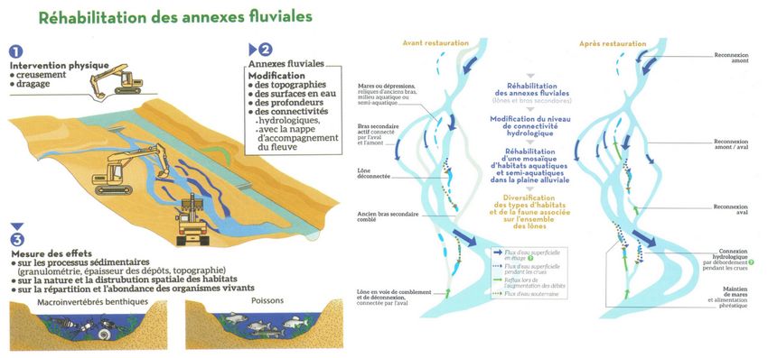
physical properties of the water body, such as the flow velocities that keep particles in suspension, preventing their deposition,
     or the tractive forces or friction stresses that allow the movement and transport of the coarser sediments on the bottom.

     There are a variety of river beds depending on the slope and flow rate that control the power of the current and the sediment
     load transported. The geological environment crossed also influences the characteristics of the river beds by influencing their
     resistance. The bed can be drawn in the sediments it carries (alluvial beds) or in the bedrock (rocky beds).

     The bed has style! The river style corresponds to the plan of the channel. The channel may be frozen or more mobile in its
     plain, as the processes of erosion, deposition and sediment transport are more active. This sensitivity to movement is related to
     the fact that the watercourse has energy and its bed is not very resistant.

     The watercourse can be single-channel and more or less sinuous, forming meanders, large curves in the plain (Figure 3). When
     the river has a winding or meandering bed, flow velocities are then asymmetric in the channel. Strong in concave banks, they
     favour their erosion. Weaker on the convex shoreline, they favour the formation of a bank resulting from the deposition of
     sediments torn from the concave bank immediately upstream. On meandering rivers in foothills areas such as the Allier [1] or
     the Ain, this meandering dynamic is active because the slope is still marked, and the channel thus moves in its plain.

      Figure 3. Left: The Ain river in its low valley, a river with meanders whose mobility has generated the nearby vegetation. [© S. Dufour].
      Right: the Sheridan river in Alaska. [© T. Dublin]

     This movement, which can reach several metres per year, is well transcribed by the riparian vegetation that is gradually
     establishing itself in the newly created environments. It is characterized by distinct landscape units, which become older and
     older as we move away from the convexity bench. The watercourse can also be composed of multiple channels. When the
     bottom load is very heavy, it cannot easily evacuate it and forms braids. The braided style is typical of alpine rivers. The water
     then flows through several channels in a minor bed dominated by pebble banks (Figure 3).

     The river is also a mosaic of ecosystems (water body, riparian environments, underground compartment). It is also a
     geographical space that belongs to someone, to a private person, to a municipality, and to the State for the older ones. The
     river has specific resources (aggregates, water, hydroelectricity). It is a space on which uses are exercised (fishing, navigation,
     leisure) and where there are sometimes conflicts (water sharing, development choices). It is also a risk area (pollution, flooding,
     bank erosion). The issues are more or less complex depending on the geomorphology of the river, the size of the alluvial plain,
     the dynamics of environmental renewal and the sensitivity of the channel to change.

     2. From riverbed to river geomorphology
     River geomorphology is concerned with geometry, the forms in which water, sediments and floats pass through, but also the
     processes of erosion, deposition and transport of sediments that govern these forms (See Focus 1, What is geomorphology).

     Initial work has thus shown that the minor bed is primarily conditioned by current floods. This gave rise to a field of research
     around hydraulic geometry following work carried out by Leopold and Wolman. These authors are often considered to be the
     pioneers in the field. The book Fluvial Processes in Geomorphology [2], first published in 1964, is a reference. The flow that
     shapes the minor bed or morphogenic flow has since been considered as the full-body flow, i.e. the flow that just overflows
     over the banks and has a return period of 1 to 2 years. The bed of an alluvial river is thus shaped by current floods and not
     by exceptional events.

Encyclopédie de l'environnement                                       3/9                                                    Généré le 27/10/2021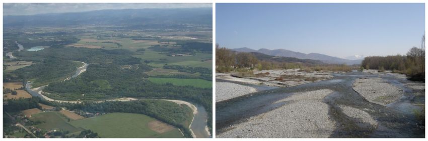
Figure 4. Simplified representation of the river system (left) with its two levels of scale (the river section and its upstream catchment) and
      the elementary interacting parameters, both upstream (control parameters) and downstream (adjustment parameters). The evolution of this
      river system is closely linked to the system of actors. [© H. Piegay]

     These approaches have renewed the vision we had of a riverbed. River geomorphology is thus nowadays part of a systemic
     perspective (see Focus 2, Different branches within geomorphology) (Figure 4). This school of thought was supported by S.
     Schumm, whose book "the fluvial system" [3] published in 1977 is also a reference. The concept of hydrosystem [4], which
     stems from the systems approach, has helped to promote bridges with ecology and to introduce river geomorphology outside the
     academic field. The European Water Framework Directive (WFD) [5], which dates from 2000, thus refers to hydromorphology,
     as do the SDAGE [6] (Water Development and Management Master Plans) published in France since 1997 to guide and plan
     water policy in the various major river basins.

     Long considered as a physical entity governed by water and sediments, conditioned by upstream controls (sediment sources and
     hydro-climatic cycle of the catchment area and their anthropogenic disturbances), the river bed also has a biological
     component that influences its form (read Alpine alluvial Landscape and biodiversity)

     A bed is the result of a complex balance between flow and resistance forces. The energy of the water depends mainly on the
     water level and the slope of the channel. The resistance of the bed depends on the size of the sediments that make up the
     bed. These are more or less heavy, cohesive, nested, and therefore more or less difficult to move by flow, to erode. Resistance
     also depends on the living and dead vegetation in the bed and on its margins. Root systems are more or less effective in arming
     the banks, retaining sediments and thus limiting erosion.

     The dynamics of plant colonization and growth is also an important factor that controls the resistance of a riverbed. Competition
     between species or biological invasion mechanisms may favour individuals that may be more or less resistant to flow. These
     factors are ecological and biological mechanisms that explain why the shape of a watercourse is not only a matter of
     physics. This is particularly the case in temperate environments where plant dynamics are active and where human actions have
     a significant influence on these dynamics. We are obviously thinking of deforestation, which can completely destabilize the
     slopes, significantly increase sedimentary inputs to rivers and profoundly transform their geometry. Single, stable and winding
     beds can thus give way in the plain to very mobile braided beds.

       Figure 5. The Ubaye, a tributary of the Durance at the confluence with the Gimette in 1895 on the left [sources: RTM services] and in
       1996 on the right. [© H. Piegay]

     Deforestation in the New Zealand mountains of the North Island or the American Appalachians are examples of spectacular

Encyclopédie de l'environnement                                         4/9                                                       Généré le 27/10/2021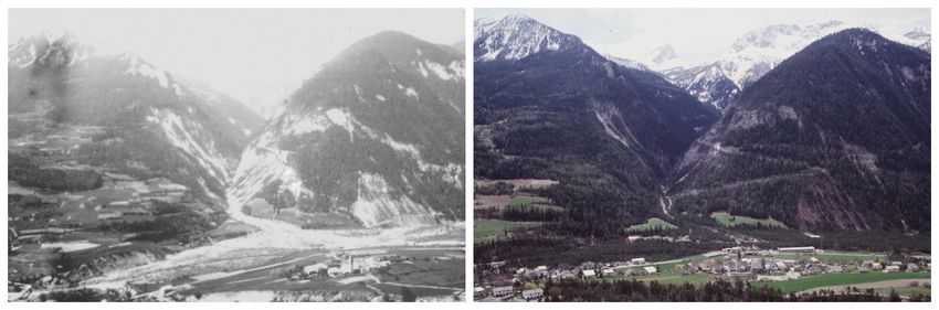
river adjustments, widely described in the scientific literature. The agricultural and pastoral decline that affected the
European mountains in the mid-20th century is another equally spectacular example. The reforestation of watersheds and
alluvial plains resulting from this diversion has helped to reduce sedimentary inputs downstream, promote channel sinking
and disconnect cobble banks. As they were less often flooded and remobilized, they showed a strong vegetalization by willows
and poplars. In some cases, this has contributed to the disappearance of braiding, an emblematic style of alpine rivers [7]
(Figure 5) (read Alluvial Alpine Landscapes and Biodiversity). The effect of colonization of rivers in the western United States
(Utah, Arizona) by the Tamaris [8], an invasive species introduced in the mid-19th century, is also a widely described case that
has led to a dramatic retraction of river beds.
3. Geomorphology, risk management, environmental quality and
sustainable development
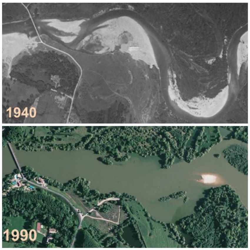
Figure 6. Two examples of the evolution of a river bed and its consequences on a bridge: on the left, the sinking of the bed can lead to
destabilization of the structure, Pont des Chaines à Die. [©F. Liebault, IRSTEA-ETNA], on the right, the raising obstructs the section and
can locally promote overflows. [© H. Piegay]
Public services in charge of river risk management [9] are increasingly taking into account geomorphological dynamics (see
Focus 3). Protective structures are installed in changing environments even though they are fixed. These changes can thus
destabilize them. These changes are also at the origin of an insidious evolution of the hazard [10] (flooding, erosion). A river can
become more mobile over time and thus erode its banks more. This may be related to the fact that the banks are less resistant, as
they have been de-vegetated, for example.
The flood regime may also have changed. Flooding is more frequent because the watershed has become less permeable due to
urbanization. This urbanization favours surface runoff, a faster concentration of these runoffs downstream and more intense
floods. If the bed deepens or, on the contrary, rises, retracts or widens, it can thus pose problems for the stability of the
structures. It may also record a change in its flow capacity before overflowing and the frequency of flooding of the plain may
itself change (Figure 6). Long considered as invariant, the hazard evolves and sometimes explains an increase in the risk of
flooding or erosion to which populations are exposed.
Encyclopédie de l'environnement 5/9 Généré le 27/10/2021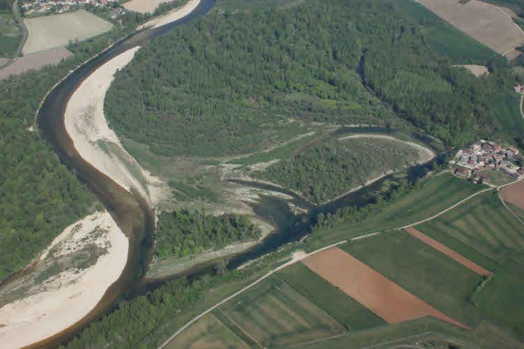
Figure 7. The Doubs at Fretterans: in 1940, it formed a beautiful winding river with banks of pebbles underlining an active solid
       transport. In the 1990s, after several years of intense mining activity, its bed became a vast lake zone interrupting sediment transit for
       several decades. [Source: Géoportail, IGN]

     The impact of aggregate extraction on the geometry of the river (Figure 7), the exercise of certain uses and the stability of
     certain developments led in 1994 to the prohibition of such extraction in minor beds [11].

     This paved the way for the recognition of a space of freedom [12] for watercourses. This area aims to satisfy users in the long
     term and ensure territorial development while protecting the river's natural infrastructure. It is an operational tool for
     sustainable development. Understanding the functioning of certain watercourses has thus made it possible to rehabilitate lateral
     erosion, long considered a scourge to be fought. This erosion is now perceived as an opportunity, an ecological and landscape
     driver, guaranteeing environmental quality and territorial attractiveness (Figure 8).

     The space of freedom has paved the way for the space of good functioning [13]. This new envelope is defined in the SDAGE
     Rhône-Méditerranée [14] of 2016-2021 It is truly a tool for planning human interventions (development, restoration,
     maintenance, preservation). It allows local stakeholders to adapt to the dynamic nature of the river and to benefit as much as
     possible from all the advantages provided by this natural infrastructure. This adaptation to the functioning of river systems
     resonates with the adaptation of human societies that is being discussed today to cope with the consequences of climate change.

Encyclopédie de l'environnement                                        6/9                                                       Généré le 27/10/2021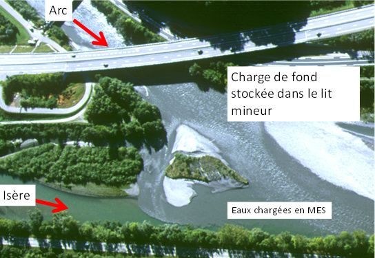
Figure 8. The Ain, an active lateral mobility, guarantees an exceptional plant biodiversity. A pioneering river in terms of conserving its
       mobility space. [Source: R. Montagnon for UMR 5600 EVS]

     Surface water is often associated with groundwater, a real reservoir for drinking water supply or irrigation. There are also
     exchanges between this groundwater and the surface water drained by the river. These exchanges are at the origin of aquatic
     habitats of great ecological richness. They are sometimes extremely important for some species during hot periods. The
     groundwater supply is a cold water pocket in the river in summer. They are therefore very important thermal refuges for trout,
     for example. Many of these habitats are in fact the result of a particular geomorphological functioning with alternating deep
     (wet) and shallow (threshold) reaches drawn in the bottom load. The mobility of sediments limits the clogging of the bottom by
     stirring them at regular intervals. This mobility also maintains water exchanges between the two compartments.

     The interruption of solid transport or the simplification of the bed bottom can alter this operation and have a direct impact
     on the ecological richness of the river. This operation is also very important for the natural filtration of water and thus
     makes it possible to ensure a certain self-purification with regard to nitrates of agricultural origin. If these changes are
     accompanied by bed sinking, the impact on the adjacent groundwater reservoir can also be significant. It is common that some
     municipalities, bordering sinking watercourses, have had to deepen their catchment wells in order to meet the demand for water.
     The increasing scarcity of water resources is also causing tensions between users (fishermen, irrigators, industrialists).

     4. Geomorphology at the service of the Rhône and its residents
     More and more scientific teams are organizing themselves to monitor the evolution of large rivers and answer sometimes
     complex questions. This is the case in Colorado, Mississippi but also in Europe, the Rhine, the Danube or the Rhône, on which a
     Rhône Sediment Observatory [15] was created 10 years ago.

     There are many questions about the Rhône. They are of interest to users, local authorities along the river, the State, the Water
     Agency, and major operators, the CNR (Compagnie Nationale du Rhône) and EDF. Is it possible to supply the Camargue delta
     or even the Languedoc beaches, which are retreating under the influence of marine erosion, with fluvial sandy inputs? Do the
     dams built along its course fill with sediment? Does this have an impact on their management or on other parts of the river
     corridor? Is it possible to improve the ecological state of the river after a century of development to make it navigable and
     produce hydroelectricity? Is it possible to also improve its flow capacity by widening it to protect against flooding? Is there a risk
     of reintroducing into the river contaminants stored for a century in the sediments of its major bed? These are all questions on
     which researchers from the Observatoire des Sédiments du Rhône (OSR), geomorphologists, hydraulics, geochemists are
     currently working. The objective is to determine the evolutionary trajectory of the river, understand its functioning,
     evaluate its solid transport, simulate its evolution, and ultimately answer these questions.

Encyclopédie de l'environnement                                        7/9                                                      Généré le 27/10/2021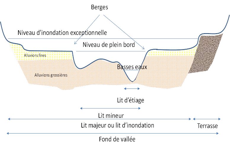
Figure 9. Example of restoration work carried out on the Rhône. [Source: RhonEco Programme, royalty-free]

     This is a long-term project, over a length of nearly 500 km that drains a catchment area of nearly 100,000 km2. Geomorphology
     today is done collectively, organized, structured, data is shared, results are public and discussed. Today, it is linked to
     ecology, chemistry, ecotoxicology, sociology and economics and contributes to an interdisciplinary approach that helps
     citizens to understand the evolution of their territory. This is the work of the Zone Atelier Bassin du Rhône (ZABR) [16]
     and more particularly of the Observatoire Homme-Milieu Vallée du Rhône (OHM VR) [17] on the river corridor from Geneva
     to the Mediterranean.

     As part of the Rhône restoration plan initiated in the 1990s, remedial work has led to the reconnection of some secondary
     branches and the recreation of dead branches along the river in order to diversify habitats. Scientific monitoring of the
     restoration of the Rhône [18] (Figure 9) has thus made it possible to assess the lifespan of these arms, to demonstrate the
     sustainability of the actions undertaken and to confirm the diversity of the habitats created.

     References and notes

     Cover image. The Drôme in the Ramières reserve [© H.Piegay]

     [1] http://www.reserves-naturelles.org/val-d-allier

     [2] Leopold L.B., Wolman M.G., Miller, J.P. (1964). Fluvial processes in geomorphology. Courier Corporation.

     [3] Schumm S.A. (1977). The fluvial system. J. Wiley.

     [4] Amoros C., Petts G.E. (1993). River hydrosystems. Masson, Paris.

     [5] http://www.eaufrance.fr/comprendre/la-politique-publique-de-l-eau/la-directive-cadre-sur-l-eau

     [6] http://www.gesteau.fr/presentation/sdage

     [7] Liébault F., Piégay H. (2002). Causes of 20th century channel narrowing in mountain and piedmont rivers of southeastern
     France. Earth surface processes and landforms 27, 425-444.

     [8] Gaskin J.F., Schaal B.A., (2002). Hybrid Tamarix widespread in US invasion and undetected in native Asian range.
     Proceedings of the National Academy of Sciences 99, 11256-11259.

     [9] https://fr.wikipedia.org/wiki/Risque_naturel

     [10] https://fr.wikipedia.org/wiki/Al%C3%A9a_(natural_risk)

     [11] https://www.legifrance.gouv.fr/affichTexteArticle.do;jsessionid=7C92280118C88D99523A184D3D96E6B0.tpdjo03v_3?idArticle

     [12] http://sierm.eaurmc.fr/sdage/documents/guide-tech-2.pdf

Encyclopédie de l'environnement                                   8/9                                                   Généré le 27/10/2021
[13] http://www.gesteau.fr/sites/default/files/guide-technique-sdage-rmc.pdf
[14] https://www.eaurmc.fr/le-bassin-rhone-mediterranee/le-sdage-du-bassin-rhone-mediterranee.html
[15] http://www.graie.org/osr/
[16] http://www.graie.org/zabr/index.htm
[17] http://ohm-vr.org/index.php
[18] https://restaurationrhone.univ-lyon1.fr/
L’Encyclopédie de l’environnement est publiée par l’Université Grenoble Alpes - www.univ-grenoble-alpes.fr
Pour citer cet article: Auteurs : (2019), Learning to live with rivers, a matter of geomorphology, Encyclopédie de
l’Environnement, [en ligne ISSN 2555-0950] url : http://www.encyclopedie-environnement.org/?p=6757
Les articles de l’Encyclopédie de l’environnement sont mis à disposition selon les termes de la licence Creative Commons
Attribution - Pas d'Utilisation Commerciale - Pas de Modification 4.0 International.
Encyclopédie de l'environnement
Powered by TCPDF (www.tcpdf.org)
9/9 Généré le 27/10/2021You can also read