THE RIVER OBSTACLES APP - TECHNICAL GUIDE 2021 - THAMES21
←
→
Page content transcription
If your browser does not render page correctly, please read the page content below
The River Obstacles App

      Technical Guide 2021
Contents
Partners……………………………………………………………………………………………………………………………………………….…3

Introduction……………………………………………………………………………………………………………………………………….…..3

     River Obstacles Surveys………………………………………………………………………………………………………………..….3

     The Movement of the European Eel and Impacts of River Obstacles…………………………………………....3-4

The River Obstacles Initiative………………………………………………………………………………………………………….………4

Survey Safely……………………………………………………………………………………………………………………………………….….4

Aims of this Guide………………………………………………………………………………………………………………………….……….5

Setting up the River Obstacles Application……………………………………………………………………………………………..5

Using the River Obstacles App………………………………………………………………………………………………………………..7

     Step 1 - Familiarising yourself with the main functions…………………………………………………….……………..7

     Step 2 - Entering your data………………………………………………………………………………………………………..…8-15

           Weirs…………………………………..……………………………………………….…………………………………………….11

           Culverts…………………………………………..…………………………………………………………………….……………11

           Flap Gates……………………………………………………………………………………………………………………..……12

           Dams…………………………………..………………………….………………………………………………………………….13

           Sluices…………………………………………………………………………………………………………………………………13

           Fords.…………………………………..…………………………………………………………………………………………….14

           Locks…….………………………………………………………………………………………………..………………………….14

           Multiple and Complex Structures………………………………………………………………………………………..15

     Step 3 - Entering your measurements…………………………………………………………………………………..…..16-18

     Step 4 - Deriving an EBAT Score (includes Crawling Media)………………………………………………………..19-23

     Step 5 - Data submission and records………………………………………………………………..……………………………24

Thank you and Feedback ………………………………………………………………………………….…………………………………..24

                                        Page 2 of 24
Partners
This Project is funded by the Government’s Green Recovery Challenge Fund. The fund is being delivered by the
National Lottery Heritage Fund in partnership with Natural England and the Environment Agency.

Project partners include Thames Rivers Trust, Action for the River Kennet, South East Rivers Trust and Thames21
with collaboration from ZSL and Thames Estuary Partnership.

Introduction
River Obstacle Surveys

Rivers in England and Wales have some of the largest numbers of obstructions to fish movement anywhere in the
world. River obstacles, both natural and manmade, can severely impact the localised movement of fish species within
rivers and, in the case of some salmonids and the European eel, the migration between rivers and the sea. These
barriers to movement can have severe consequences for populations of fish by limiting their ability to move between
feeding and spawning grounds. Because of this, river obstacles are considered one of the major threats to the
populations of some fish species in the UK. Surveying rivers to locate and assess the passability of river obstacles is
therefore a key first step in any catchment wide, fish conservation plan. The data gathered through this means allows
the development of a strategic approach to reconnecting rivers for the free movement of fish species.

The Movement of European Eels and Impacts of River Obstacles

There have been considerable declines (90-95% based on best available data) in European eel (Anguilla anguilla)
recruitment across large extents of its geographical range since the 1980s, with barriers to migration in freshwater
being highlighted as one of the principal threats that is preventing species recovery. The European eel is an iconic
migratory species, spawning in the Sargasso Sea before making its way to rivers such as the River Thames and its
tributaries where they grow and mature. Glass eels (not yet developed pigmentation) enter estuarine systems
through active and passive migration, with some individuals migrating within the freshwater environment over the
course of their lives. After the first year or two, two behavioural strategies of European eels have been recognised:
home range dwellers (establish themselves in a given area for a number of months or years) and nomads (move

                                                     Page 3 of 24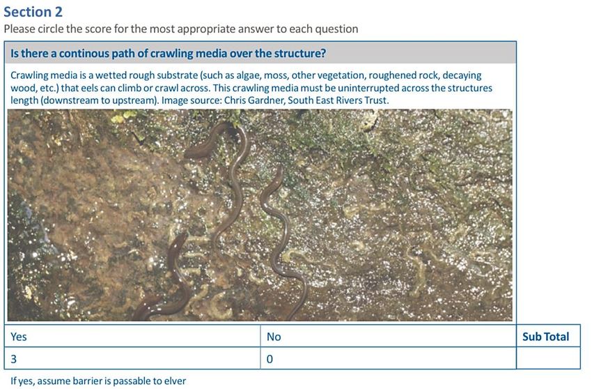
within and between water bodies, including fresh and saline environments). These behavioural and lifecycle traits of
the European eel highlight the importance of connectivity in the success of this species.

The swimming capabilities of eels, particularly those in younger lifecycle stages, are poor and they are unable to
jump over even small structures and barriers. Man-made structures can add significant obstruction to European eel
movement, with barriers such as locks, weirs and sluices blocking migration paths or diverting water in such a way
that the movement by the species becomes exhausting and, in many cases, impossible.

The River Obstacles Initiative
The aim of the River Obstacles initiative is to help restore and reconnect our rivers. Many of our rivers across the UK
and Europe are fragmented by obsolete man-made barriers that disrupt natural processes.

Records submitted using the River Obstacles app are used to update, expand and improve the River Obstacles dataset.
This dataset is an inventory of over 30,000 weirs, waterfalls, sluices, dams, culverts, fords and flap gates in England
and Wales which was created initially as a desktop exercise using digital maps to identify features which crossed the
river network. App users submit records which are manually verified, then added to the dataset, which is openly
available and updated regularly, so the data can be used to plan and deliver improvements to the river environment.
The information received from this app will be used by public bodies, environmental organisations, trusts and local
authorities to identify redundant man-made obstacles that can be removed from rivers, and to prioritise
improvements to other obstacles that will yield the biggest environmental improvements.

Survey Safely
         The organisation hosting your survey will provide a detailed risk assessment. Please follow these generic
rules to help keep you safe whilst out on survey:

    1. Survey in pairs or preferably in groups
    2. Lead survey must have a phone to check in and out with NGO contact and in case of emergency,
    3. Do not enter the river (unless instructed to do so by your Trainer),
    4. Do not climb over barriers or access private land,
    5. Be aware of Giant Hogweed,
    6. Avoid surveys in extreme weather,
    7. Make sure you are aware of specific hazards such as golf courses,
    8. COVID- follow local guidance,
    9. Be aware of exposure to disease and infection,
    10. Take care to avoid slips, trips and falls,
    11. Be mindful of vehicles/traffic,
    12. Be aware of agricultural practices

                                                     Page 4 of 24
Aims of this Guide
    1. To provide guidance for volunteers using the River Obstacles App
    2. To detail the instructions on how to calculate an Eel Barrier Assessment Tool score for structures.
This guidance document is designed to be used in conjunction with the Eel Barrier Assessment Tool Publication: A
Field Guide for Assessing the Passability of Man-Made River Structures by European Eels, published by ZSL.

The Eel Barrier Assessment Tool Publication can be downloaded here: www.zsl.org/conservation/regions/uk-
europe/eel-conservation

    ●   What happens to the data and how is it used?

All data are stored on a secure central database that is accessible to the partners. Records of obstacles will first be
verified by the partners to ascertain whether they relate to obstacles already known about or whether they are new.
For new obstacles, it may be necessary for further site visits to be made in order to determine the exact type of
obstacle and the impact it is causing.

Verified records will be made openly available for use by the project partners and any other interested parties to
plan and deliver improvements to the river environment.

For example, SEPA and the EA may use records in their Water Framework Directive river classification schemes in
order to help determine priorities for improvements as part of the river basin planning process. A kayaking group
may use the records to highlight potential man made and natural hazards to those planning a trip along a river.

Setting up the River Obstacles Application
Download the ‘River Obstacles’ Application to your chosen device from the App store (iPhone) or The Google Play
Store (Android).

                                                      Page 5 of 24
Once the app is downloaded, you will be taken to a home screen where you can now Sign up. Click account, (Sign in -
if you have already registered) and click the Sign-up option at the bottom of the screen. Fill in your details and create
a River Obstacles username and password.

 Important Information!

 At this stage you will also be given the option to tick a box if you would like to receive project news and occasional
 updates from the project partners. Before clicking the Sign-up button at the bottom of the page you will need to
 tick the box to confirm that you have read and agreed to the Terms & Conditions and consent to the Privacy Policy.

You will now be sent an activation email to the email address you used to Sign-up. This might take a couple of minutes
to come through and be sure to check your junk inbox just in case! Once you receive the email, please click the link
provided to complete a verification of your account. You are now ready to Sign in and start using the River Obstacles
App!

                                                      Page 6 of 24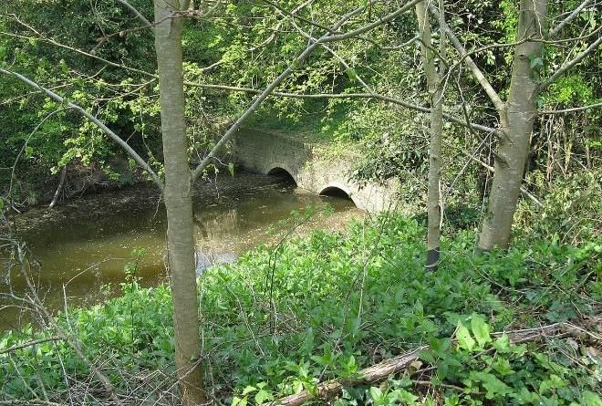
Using the River Obstacles App
Step 1 - Familiarising yourself with the main functions: Access to Records, Account and More (Safety First, About the
Partners, Data & Privacy and App Information), as well as options to toggle the survey tracks on/off, change the base
map layers (see instructions below) and a location indicator button can all be found on this App landing page/home
screen. You can return         to this home screen view at any time by clicking the button .

                                                    Page 7 of 24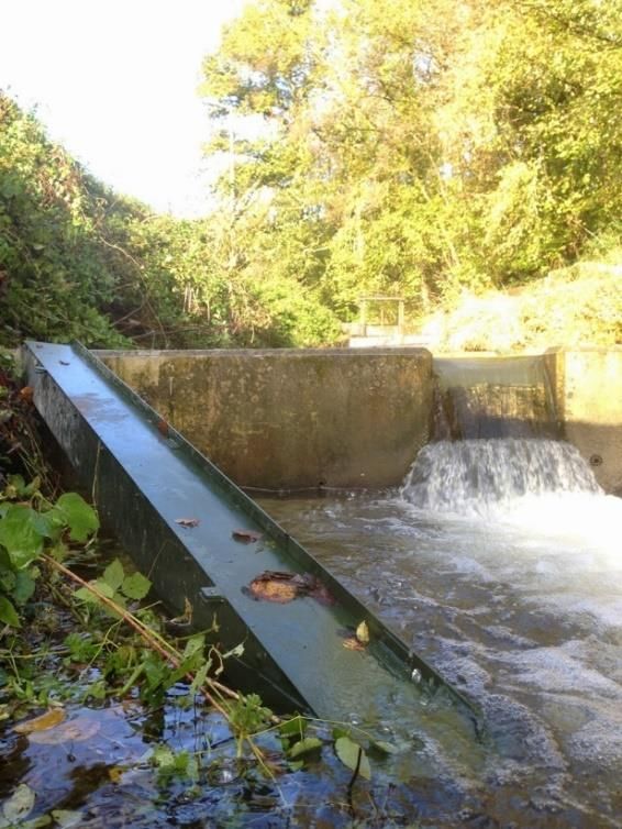
Changing the Base Map: Click the Base map button         to switch between Outdoor, Satellite and Street maps to suit
your preference.

Step 2 - Entering your data:

To start entering data into the app, click + add at the bottom of the Home screen. This will take you to a page with the
option to Start a survey or Add a single sighting. For the purposes of ObstacEELS, please select the Start a survey
option so that your whole survey can be logged. Obstacles should be assed from downstream, looking upstream.

                                                                                   Important Information!

                                                                                   Please do not enter the river
                                                                              to obtain any measurements
                                                                              unless instructed to do so by your
                                                                              Trainer. Instead, these
                                                                              measurements should be taken
                                                                              from the river/stream bank and
                                                                              realistic estimations for
                                                                              dimensions should be made.

                                                     Page 8 of 24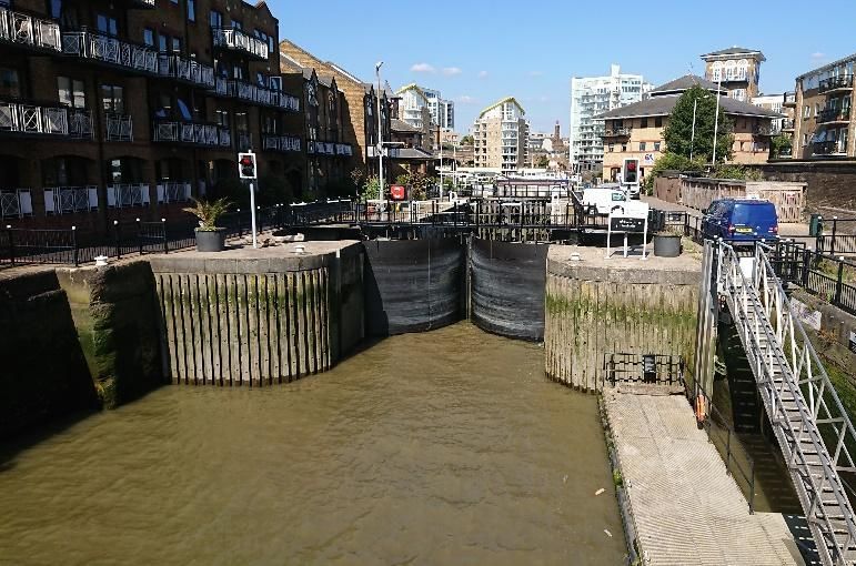
You will now be able to see the Start a Survey screen. At this stage you can edit the Survey Name before clicking the
Start button at the bottom of the screen. For the Site Name, please fill this in based on nearby signage or local
knowledge. If you are unsure, you can either create a name to best describe your current location (avoiding using any
personal names) or simply write ‘unknown’ in this box. You have the choice to continue in Map View or in List View.
After proceeding by clicking the + Add Barrier button you will be taken to the New Obstacle screen. Here you will find
several data entry boxes (boxes with a red * are compulsory boxes which will need to be filled in before you can
proceed further or add a survey to the database). Obstacle Photos can be added at this stage with the option to upload
a file that you already have saved to your device or to take a new photo.

 Important Information!

 Please check your location and the accuracy of this before logging a New Obstacle! Your location will be
 represented by a blue dot on the live map and the accuracy can be seen in the top right corner of the screen.
 Please ensure that your location accuracy is at least 10m. If your location does not look right and the accuracy is

 greater than 10m then refresh your location by pressing the         button.

 Important Information!

 If you identify a structure that is not currently acting as an obstacle but can be opened and closed (e.g. a sluice
 gate at low flow) then please be sure to record this as an obstacle and add in to the additional information
 section that this was ‘open’ and not acting as a barrier at the time of the survey, but that it could be in the future.

                                                      Page 9 of 24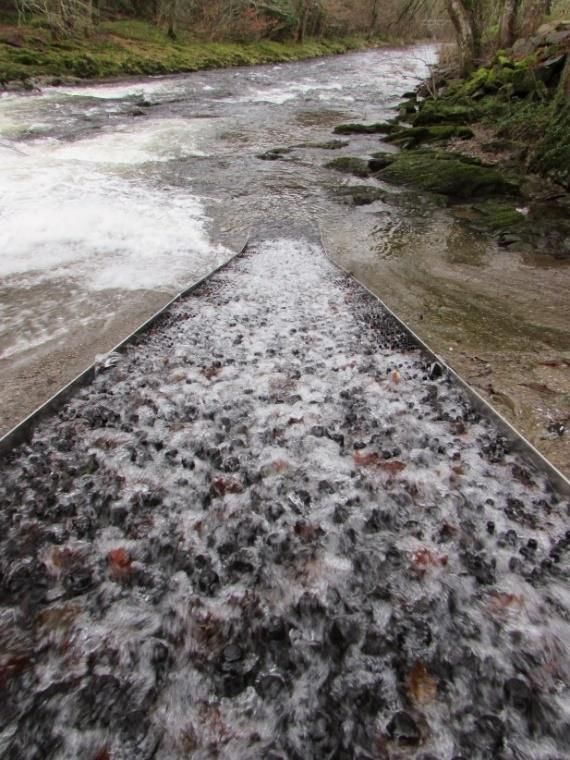
When adding a saved photo or uploading a new photo you will have to select your desired privacy settings on your
device. If you choose the Use File option, you will have the choice to Select Photos (choose specific photos that the
app can access) or Allow Access to All Photos. If you choose the Take Photo option, you will need to select the OK
button to be able to proceed. If at any point you wish to change these settings – this can be done in the privacy
settings on your device.

 Important Information!

         Please avoid photographing the following:           Please try to capture the following where possible:

                                                        -   Bank to bank view of the obstacle
     -     Images that show identifiable people,
     -     An address or part of an address,            -   A clear unobstructed view of any distinctive features
     -     Vehicle number plates or branding.

                                                     Page 10 of 24
As you scroll down the page you will reach the Advanced Survey (optional) section. Click on the Details panel and
select either a Man Made or Natural obstacle depending on the obstacle you wish to record.
● If you choose Natural, the following obstacle options will appear: Permanent (e.g. waterfall), Temporary (e.g.
log jams and fallen trees)
● If you click on Man Made the following options will appear:
Weirs (with a choice of Vertical, Sloping or Stepped with
another ‘yes/no’ option to select whether the weir forms
part of the footing structure of a bridge) - A weir is a small,
low head dam built across a river or a stream to control the
upstream water level.
Photo: (Left) ZSL, (Right) Marathon, River Medway, WikiCommons.
Culverts (with a choice of Perched, Not perched): a structure built to allows a stream or river to flow through/under
an obstruction. Culverts can be embedded into the ground (not perched) or raised (perched) with the outlet being
higher than the elevation of the downstream water. Perched culverts can be constructed intentionally or can be caused
by erosion at the outlet from high flows, scouring the channel bed.
Perched Not Perched
Photo: (Left) Brendanboshea, WikiCommons, (Right) Dave Spicer, Arun canal twin culverts, WikiCommons.
Please note: These can often be confused with Combined Sewer Overflows (CSOs), surface water outfalls and land
drains!
Page 11 of 24Flap gates (with a choice of: Side Hung and Top Hung, Non-Tidal and Tidal): A flap gate is a flow control device that
allows water to flow through it in only one direction.
Tidal flap gates close during incoming (flood) tides to prevent tidal waters from moving upland and open during
outgoing (ebb) tides to allow upland water to flow into the receiving body of water.
Two factors influence the degree to which a flap gate represents a physical barrier for fish. Firstly, the length of time
the gate is closed for and the secondly, the size of the opening. All flap gates act as a total barrier to fish passage
during the time they remain completely closed.
Top hung flap gates, sometimes referred to as ‘tidal Side Hung Flap Gates, also commonly known as ‘tidal
flaps’ range greatly in size from tens of centimetres to doors’, are generally larger than top hung flap gates
several metres in width and depth. They are generally and have an appearance similar to lock gates.
rectangular or circular in shape.
Photo: (Top Left) Heather Bell, The Rivers Trust, (Top Right) Adrian Fewings, The Environment Agency, (Bottom Left) Emma
Washburn, The Environment Agency, (Bottom Right) Adrian Fewings, The Environment Agency.
Page 12 of 24Dams– A dam is a barrier built to block or limit the flow of water that can come in a variety of shapes and sizes running
the width of a river system Some fish species are unable to move upstream of even low height dams.
Photo: SERT, Weirwood Reservoir on the Medway.
Sluices are movable barriers that are opened and closed to control water levels and flow rates. Sluices are traditionally
a wood or metal barrier sliding in grooves that are set in the sides of the waterway and come in many shapes and
sizes. Sluices can often be built into/around other structures such as weirs.
Photos: Heather Bell (The Rivers Trust), North Somerset.
Page 13 of 24Fords – A ford is a structure in a river or stream which creates a shallow are to be crossed by vehicles or on foot. Fords
can create several barriers to fish passage including a vertical drop (or step up for fish migrating upstream), shallow
water especially during summer migration, when water flows are lowest and high water compared to the natural
stream with no resting areas available.
Photo: (Left) Roger Kidd / Trescott Ford, Staffordshire / CC BY-SA 2.0, WikiCommons, (Right) John Walton / Rawney Ford /
WikiCommons CC BY-SA 2.0.
Locks– A lock is a device used to improve crossing and navigation in rivers and canals, raising and lowering boats and
other vessels between stretches of water of different levels. Please Note: if selecting this obstacle option, you will not
be required to enter any measurements.
Photos: Wanda Bodnar, Thames Estuary Partnership.
Page 14 of 24Multiple and Complex Structures – *For where the user is recording a complex obstruction that is made up of several
‘obstacle types’. (This will commonly apply to multiple obstacles such as lock and weir barriers)
There is not an option for recording these
multiple barriers within the app, instead
please ensure that clear descriptions are
added to the ‘Add Notes’ section. If the
obstacle elements are joined then this should
be recorded as one obstacle with Multiple
components (acknowledged within the
notes). If they are near one another but
separated then they are to be recorded as
separate obstacles within the app.
Photo: Small scale example) David P. Howard, Alveston Sluice
The man-made barriers encountered in rivers and Weir on River Avon (Sluice in centre), WikiCommons.
can often be complex non-uniform structures.
These can vary across their width (bank to
bank or ‘transversally’) and across their length
(downstream to upstream or ‘longitudinally’).
Complex structures can contain multiple
structure types across their width e.g. a sluice
gate with two weirs on either side (see image
below). Structures may also include a vertical
lip at the crest or a step at the toe of the weir.
These can present an additional challenge to
migrating eels and, in some cases, make an Photo: Large scale example) Maxwell Hamilton, The Weir at
Teddington Lock (2011), WikiCommons.
otherwise passable structure a barrier.
Guidance for measuring complex barriers can be found in the EBAT Guide.
Page 15 of 24Step 3 - Entering your measurements:
Important Information!
REMEMBER, do not enter the river unless instructed to by your Trainer. If you have been instructed not to enter
the river then these measurements should be taken from the river/stream bank and realistic estimates for
dimensions should be made.
After selecting the type of obstruction and specifying the obstacle details where necessary, the measurements of the
obstruction can be added. Depending on the obstacle type selected, the measurement data entry boxes will differ.
Ensure that all data are entered in the specified unit of measurement. Diagrams of how to measure each obstacle
can be seen along with important specifications and guidance for measuring given where necessary. Once
measurement submission is completed, double check your data and click Save. Please note: You can edit these data
by going back into the Measurements tab.
You now have the option of adding in any fish passes/eel passes present,
the number of these can be adjusted using the + and – buttons, and there
is an option to upload a saved image/take a new image of the pass.
Page 16 of 24Important Information!
These can sometimes be difficult to spot - If you are unsure of whether you have seen an eel or fish pass, please
photograph the area and make this known within the notes section, so that this can be revisited during the
verification process.
Eel Passes: (also referred to as elver passes) are modifications made within waterways to mitigate the effects of
obstacles (mostly man-made obstacles) to eel. These typically include ‘up and over’ passes, ‘horizontally mounted eel
tiles’ and ‘vertically mounted eel tiles’.
Horizontally mounted eel tiles
Up and over eel pass
Vertically mounted eel tiles
Page 17 of 24Fish Passes: Similarly, fish passes come in many shapes and sizes and include any form of conduit, channel, lift, other
device/structure which facilitates the free passage of migrating fish over, through or around an obstacle, whether
natural or man-made.
Photos: (Left & Middle) The Environment Agency, (Right) South East Rivers Trust.
Important Information!
At this stage you will now see the Water Height data entry section. Please ignore this box for now as this will not
be needed for the ObstacEELS survey.
After recording any eel or fish passes that are present,
please fill in your Experience Level and press OK once
you have selected the most suitable option. (For the
purposes of the ObstacEELS survey, please select Non
Expert as this is a pilot study).
Page 18 of 24After submitting your experience level, the final data you will be asked to enter is the EBAT Score. The EBAT (Eel Barrier
Assessment Tool) is a bankside method for determining the passability of a weir to eel.
Step 4 - Deriving an EBAT Score (includes Crawling Media):
This score can be derived from four main criteria relating to the structure/slope, length and velocity and incorporates
crawling media. The higher the score, the greater the passability likelihood for eel. This tool acts as a rapid assessment
and indicates which parts of complex structures should be assessed. Please Note: Not all structures can be EBAT
assessed (e.g. culverts and flapgates.)
In Section 1 of the guide, you will be asked to follow a flow chart to assess the structure.
Page 19 of 24This flow chart is designed so that the least limiting transversal section of a structure (across the river’s width) is
assessed and that the most limiting features on the longitudinal section of a structure (downstream to upstream) are
assessed.
From here you will move to Section 2,
where you will be asked to choose a score
for Crawling Media. Crawling media is a
wetted rough substrate (such as algae,
moss, other vegetation, roughened rock,
decaying wood, etc.) that eels can climb or
crawl across. This crawling media must be
uninterrupted across the structure’s length
(downstream to upstream). Photo: Thames Rivers Trust.
A yes/no answer is required in the separate section for this parameter in the River Obstacles App and a score is
required for the EBAT guide, to indicate whether or not there is a continuous path of crawling media available over
the obstacle structure that you are logging.
Page 20 of 24Following this, you will be required to give an estimate for the slope of the structure. According to whether the slope
you are measuring is 1 in 1 or Variable (e.g., stepped, has a lip at the crest or a step at the toe)
a score from 1-4 can be matched (shown below each option). Fill in your score to the Sub Total box.
After completing an estimate for the slope of the structure you will now be asked to assess the length of the slope
(this applies to the slope across the entire structure being assessed, downstream to upstream). There is an option to
note down the number of steps if the structure is stepped. Length options 0-2m, >2-6m, >6-9m and ≥10m correspond
to score values below the diagram ranging from 1-4. Once you have selected a score, write this in the Sub Total box.
The next stage of assessment is to calculate the approximate velocity over the slope. Two methods can be used to
establish a score for this question. The method using a float method or by using the pacing method. There is also a
space to record the location from which velocity was recorded. Once an option has been selected based on the
approximation of velocity, the corresponding score should be entered into the Sub Total box.
Page 21 of 24The final question for the assessment asks whether the structure is assumed to be passable to elver. A yes/no box is
provided for the answer. Following this, all Sub Total scores should be added to give the final Total Passability
Score/EBAT Score. This final EBAT score can be compared in the Score Range table seen below.
Score Range
10-15 Unlikely to represent a major barrier to upstream migration
05-09 Partial impact, obstacle may impede passageNow that your EBAT Score has been derived, it can be entered into the River Obstacles App. You will be able to scroll
between numbers to find values ranging from 0 to 15. Once selected, click the Confirm button. You can now check
your score before clicking the Save button.
Page 23 of 24Data entry is now complete (please ensure you check that all necessary information has been included as well as
photographs where possible). In the App there is now an option to add another barrier by clicking the + Add Barrier
button or you can select Finish. Once you select Finish, you will see a notification pop up, asking if you are sure that
you wish to finish your survey. App users will still be able to review and edit their sightings until the data is submitted
by clicking the Submit button on the following screen.
Important Information!
Please remember to press Finish when you have reached the end of your
survey, otherwise the app will continue to track your location data, and
this could disrupt the survey data.
Step 5 - Data submission and records:
Once you have submitted your first Survey – this can be viewed in the
Records page which can be accessed from the App Home Screen by clicking
the tab.
All submitted surveys will be stored here as either Pending or Submitted
records. Please note: sighting data cannot be edited once it has been
submitted and this page can only be used to view your records.
To view and download data that has been submitted to the app and verified, please visit: https://river-obstacles-
theriverstrust.hub.arcgis.com/
Thank you!
Thank you for using the River Obstacles App and for taking part in the ObstacEELS Project, we look forward to
receiving your survey data! Your comments and views on how to improve this Guidance Document would be
most welcome and should be sent to your survey organiser.
Page 24 of 24You can also read