2019 ASSESSMENT METHODOLOGY - MULTI-RESIDENTIAL LAND - City of Edmonton
←
→
Page content transcription
If your browser does not render page correctly, please read the page content below
2019
ASSESSMENT
METHODOLOGY
MULTI-RESIDENTIAL LAND

A summary of the methods used by the City of Edmonton in
determining the value of multi-residential land properties in
Edmonton for assessment purposes.

edmonton.ca/assessment

Revised: February 21, 2019 (see revision history)
2019 Multi-Residential Land
Assessment Methodology Page | 1
Table of Contents
Scope 2
Introduction 2
Mass Appraisal 4
Valuation Models 5
Approaches to Value 6
Property Groups 7
Sub-Group 7
Direct Sales Approach 7
Time Adjustment 8
Zoning 9
Density 9
Height 9
Floor Area Ratio 10
Effective Zoning 11
Variables 12
Adjustments 13
Servicing 13
Other Adjustments 14
Site Improvements 15
Land Use Definitions 15
Sample Assessment Detail Report 16
General Practices 17
Methods to Adjust Comparables 17
Quantitative Adjustments 17
Qualitative Analysis 18
Revision History 18
References 19
Appendix 20
Maps 20
Measure Conversion Chart 27
Zone Summary 28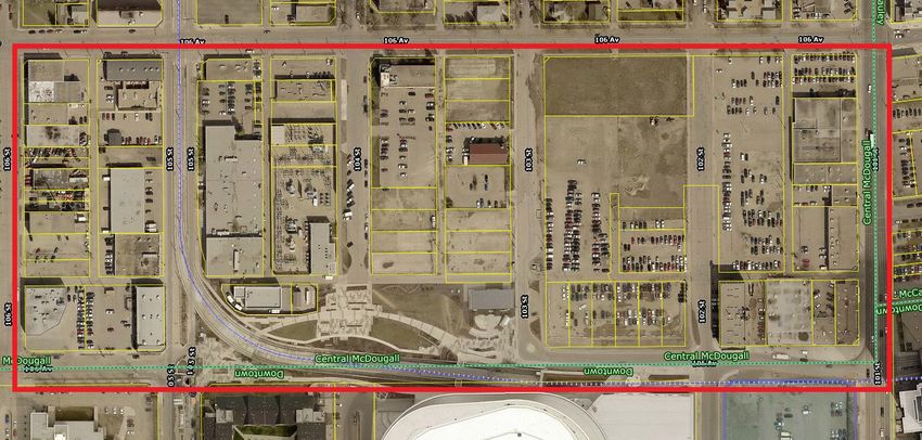
2019 Multi-Residential Land
Assessment Methodology Page | 2
Scope
This guide is an aid in explaining how multi-residential land properties are valued for assessment
purposes. It sets out the valuation method and procedure to derive market values. The information
presented in this guide is aimed at deriving values for a group of properties with similar property
characteristics. In some circumstances, not every property’s valuation parameters will be covered.
The guide is intended as a tool; it is not intended to replace the assessor’s judgment in the valuation
process.
This icon signifies when legislation is quoted.
Introduction
Property assessments in the City of Edmonton are prepared in accordance with the requirements of the
Matters Relating to Assessment and Taxation Regulation, 2018, Alta Reg 203/2017, (hereinafter
“MRAT” ). This regulation establishes the valuation standard to be used, defines the procedures to be
applied, and proposes objectives for the quality to be achieved in the preparation of assessments. The
legislation requires the municipality to prepare assessments that represent market value by application
of the mass appraisal process. All assessments are expected to meet quality standards prescribed by the
province in the regulation.
Property assessments represent:
● an estimate of the value
● of the fee simple estate in the property
● as it existed on December 31, 2018
● would have realized if it had been sold on July 1, 2018
● on the open market and under typical market conditions
● from a willing seller to a willing buyer
The assessment is a prediction of the value that would result when those specific, defined conditions are
met.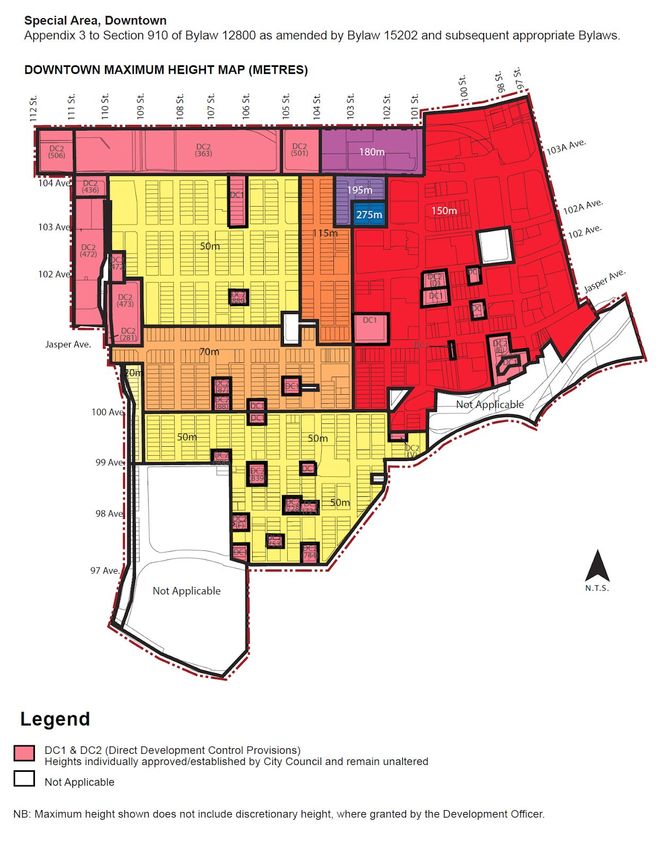
2019 Multi-Residential Land Assessment Methodology Page | 3 Both market value and property, along with additional terms are defined in the Municipal Government Act, RSA 2000, c M-26 (hereinafter the “MGA” ) and MRAT :
2019 Multi-Residential Land
Assessment Methodology Page | 4
Mass Appraisal
Mass appraisal is the legislated methodology used by the City of Edmonton for valuing individual
properties, and involves the following process:
● properties are stratified into groups of comparable property
● common property characteristics are identified for the properties in each group
● a uniform valuation model is created for each property group
The following two quotations indicate how the International Association of Assessing Officers
distinguishes between mass appraisal and single-property appraisal: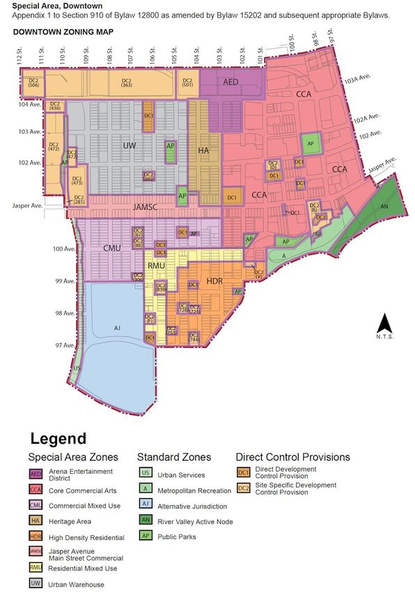
2019 Multi-Residential Land
Assessment Methodology Page | 5
For both mass appraisal and single-property appraisal, the process consists of the following stages:
Mass Appraisal Single Appraisal
Mass appraisal is used to The client specifies the nature of
determine the assessment base the value to be estimated,
Definition and Purpose for property taxation in including rights to be valued,
accordance with legislative effective date of valuation, and
requirements any limiting conditions
Mass appraisal requires a The extent of data collection is
continuing program to maintain a specific to each assignment and
Data Collection current database of property depends on the nature of the
characteristics and market client’s requirements
information.
Mass appraisal is predicated on Market analysis includes the
Market Analysis
highest and best use analysis of highest and best use
Valuation procedures are Subject property is the focus of
predicated on groups of the valuation. The analysis of
Valuation Model
comparable properties comparable properties is generally
six or less
The testing of acceptable analysis The reliability of the value
and objective criteria estimate is more subjective.
Validation Acceptability can be judged by the
depth of research and analysis of
comparable sales
Valuation Models
A valuation model creates an equation of variables, factors and coefficients that explains the
relationship between estimated market value and property characteristics.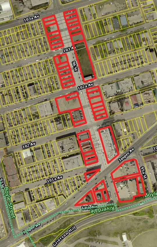
2019 Multi-Residential Land
Assessment Methodology Page | 6
● variables are created from property characteristics
● analysis of how variables affect market value
Valuation Model
● factors and coefficients are determined
● the resulting valuation models are applied to property characteristics
Depending on the property type multiple regression analysis or other mass appraisal techniques are
used to determine variables, factors and coefficients.
An assessed value is calculated by applying the appropriate valuation model to individual properties
within a group.
Approaches to Value
The most common approaches to determine market value are the direct sales, income, and cost. Each
emphasizes a particular kind of market evidence.
Typical market value (or some other characteristic) is determined by
Direct Sales referencing comparable sales and other market data. It is often used when
Approach sufficient sales or market data is available. It may also be referred to as the
Sales Comparison Approach.
This approach considers the typical actions of renters, buyers and sellers
when purchasing income-producing properties. This approach estimates the
Income Approach
typical market value of a property by determining the present value of the
projected income stream. Often used to value rental or leased property.
Typical market value is calculated by adding the depreciated replacement
cost of the improvements to the estimated value of land. It is often used for
Cost Approach
properties under construction or when there is limited market data
available.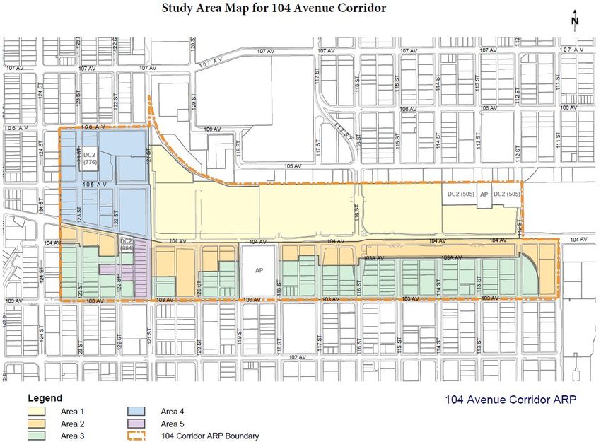
2019 Multi-Residential Land
Assessment Methodology Page | 7
Property Groups
The use of a property determines the property groupings and the valuation model applied.
Multi-Residential
Multi-Residential group consists of investment properties with four or more dwelling units, each having
one or more rooms accommodating sitting, sleeping, sanitary facilities and most often has a kitchen.
Excluded from this group are those still under construction and dormitories.
Sub-Group
Some property groups have sub-groups based on property characteristics. This guide is for the Multi
Residential Land sub-group.
Multi-Residential Land is a vacant parcel of land zoned for multi residential uses. Some parcels may
have minor improvements such as paving or fencing.
Direct Sales Approach
For this property group, the assessment is determined using the Direct Sales approach. It is the most
appropriate method of valuation for multi-residential land in the City of Edmonton because it mirrors
the actions of buyers and sellers in the marketplace and sufficient sales data exists in order to derive
reliable market estimates.
Support for the Direct Sales approach comes from several reputable sources, for example:
This approach is usually the preferred approach for estimating values for
residential and other property types with adequate sales. (IAAO, 2013, sec.
4.3).
The Direct Comparison approach provides the most credible indication of
value for owner-occupied commercial and industrial properties, i.e.,
properties that are not purchased primarily for their income-producing
characteristics. These types of properties are amenable to direct comparison
because similar properties are commonly bought and sold in the same market.
(Appraisal Institute of Canada [AIC], 2010, p. 13.4).
Appraisers should rely on several sold properties as comparable sales. Three
to five comparables are usually adequate, but a larger number improves
confidence in the final estimate, increases the awareness of patterns of value,
and stabilizes assessments over time . (UBC, 2009, p. 7.2).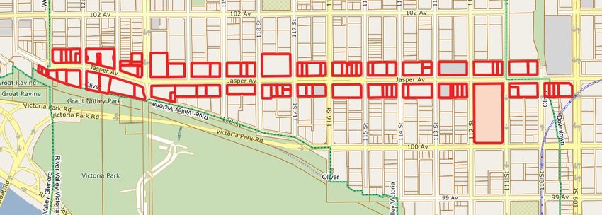
2019 Multi-Residential Land
Assessment Methodology Page | 8
Sales
The City of Edmonton validates all land title transactions (sales). The validation process can include site
inspections, interviews with parties involved, a review of land title documents, corporate searches, third
party information, and sale validation questionnaires.
The City of Edmonton reviews sales occurring from July 1, 2013 to June 30, 2018 for valuation of
multi-residential land properties. Time adjustments are applied to sale prices to account for any market
fluctuations occurring between the sale date and the legislated valuation date.
Sale price reflects the condition of a property on the sale date and may not be equal to the
assessment.
Time Adjustment
Time adjustment refers to the adjustment applied to the sale price of a property to account for the
effects of price changes reflected in the market between the date of sale and the July 1, 2018 valuation
date. The time adjustments are shown below.
2019 Time Adjustment Factors for Multi-Residential Land
Months TAF Months TAF Months TAF Months TAF Months TAF
Jul 13 1.1591 Jul 14 1.0788 Jul 15 1.0243 Jul 16 1.0121 Jul 17 1.0000
Aug 13 1.1522 Aug 14 1.0724 Aug 15 1.0233 Aug 16 1.0111 Aug 17 1.0000
Sep 13 1.1453 Sep 14 1.066 Sep 15 1.0223 Sep 16 1.0101 Sep 17 1.0000
Oct 13 1.1385 Oct 14 1.0586 Oct 15 1.0212 Oct 16 1.0091 Oct 17 1.0000
Nov 13 1.1317 Nov 14 1.0512 Nov 15 1.0202 Nov 16 1.0081 Nov 17 1.0000
Dec 13 1.1249 Dec 14 1.0439 Dec 15 1.0192 Dec 16 1.0071 Dec 17 1.0000
Jan 14 1.1182 Jan 15 1.0366 Jan 16 1.0182 Jan 17 1.006 Jan 18 1.0000
Feb 14 1.1116 Feb 15 1.0294 Feb 16 1.0172 Feb 17 1.005 Feb 18 1.0000
Mar 14 1.1049 Mar 15 1.0284 Mar 16 1.0162 Mar 17 1.004 Mar 18 1.0000
Apr 14 1.0983 Apr 15 1.0274 Apr 16 1.0151 Apr 17 1.003 Apr 18 1.0000
May 14 1.0918 May 15 1.0264 May 16 1.0141 May 17 1.002 May 18 1.0000
Jun 14 1.0853 Jun 15 1.0253 Jun 16 1.0131 Jun 17 1.001 Jun 18 1.0000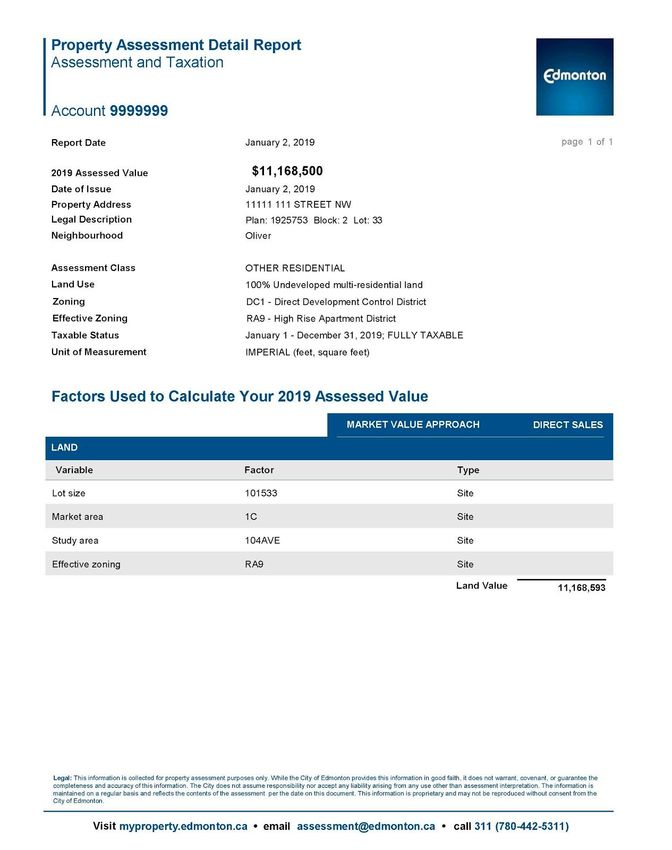
2019 Multi-Residential Land
Assessment Methodology Page | 9
Zoning
The rules and regulations for land development within Edmonton are contained in the Zoning Bylaw, No.
12800.
A multi-residential zone summary is located in the appendix.
Multi-residential land use zones vary with regard to allowable Density, Height, and Floor Area Ratio
(FAR).
Density
Height2019 Multi-Residential Land
Assessment Methodology Page | 10
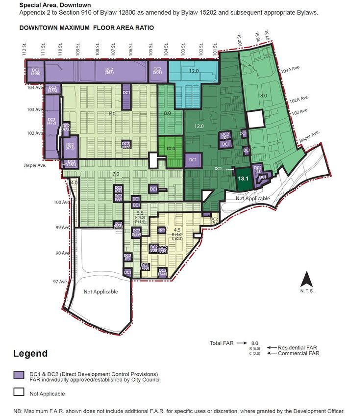
Floor Area Ratio
Floor area ratio (FAR) is the factor used determine the total living area that is allowed to be
built. The FAR is calculated as follows:
Floor Area Ratio (FAR) multiplied by total site area = total allowable living area2019 Multi-Residential Land
Assessment Methodology Page | 11
Effective Zoning
Not all property conforms to the zoning use set out in the Zoning Bylaw. In these cases an effective
zoning is applied to reflect the current legal use and/or development potential of the property. The
effective zoning may differ from the actual zoning. The two most common scenarios where effective
zoning may be applied are:
● Actual zoning is Direct Control (DC) or other specialized zoning. In these cases the most
comparable multi-residential zoning will be applied as the effective zoning. For example, if a DC1
zoning provision allows for development most similar to those with an RA7 zoning, that property
will have an effective zoning of RA7 even though the actual zoning is DC1.
● Legal non-conforming use: A legal non-conforming use is one that was lawfully in existence
before a new zoning bylaw came into effect. Since the lawful use existed before the zoning was
changed its legal non-conforming use may continue and an effective zone reflecting current use
is applied.
In cases where a legal non-conforming use is discontinued for six (6) or more months, any future
use must conform to the current Zoning Bylaw.2019 Multi-Residential Land
Assessment Methodology Page | 12
Variables
Below is the list of variables that affect the assessment value for 2019.
Market area Lot size
Study area Ravine influence
River valley influence Effective zoning
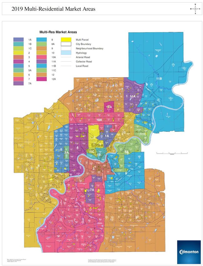
Market area: Market area is a geographic area defined using location boundaries. See map titled 2019
Multi-Residential Market Areas in appendix.
Lot size: Lot size is the area of a specific parcel determined through a Geographic Information System
(GIS) and Alberta Land Titles.
Study area: Study area is a sub-group or sub-sector of properties in neighbourhoods or a series of
neighbourhoods that show different market trends. These properties are assigned to study areas to
more accurately analyze and value the market trends in these locations.
The 2019 multi-residential land study areas are:
● Downtown ● ICE Phase 2
● 104AVE ● Armature
● Keswick ● Jasper Avenue West
Maps for each of these study areas are located in the appendix of this document.
Ravine influence: A property is in close proximity to a ravine (land included in the City's Ravine System
Protection Overlay
[https://webdocs.edmonton.ca/zoningbylaw/ZoningBylaw/Part2/Overlays/811_North_Saskatchewan_Ri
ver_Valley_and_Ravine_System_Protection_Overlay.htm]).
● Abutting: Property backs directly onto a ravine or is separated from it only by parks, green
spaces or walking trails.
● Across from: Property is separated from a ravine by a road or lane normally used by local traffic.
The separation by the local road or lane may also include parks, green spaces and walking trails.
River valley influence: A property is in close proximity to or within the boundaries of the North
Saskatchewan River Valley (land included in the City's protection overlay
[https://webdocs.edmonton.ca/zoningbylaw/ZoningBylaw/Part2/Overlays/811_North_Saskatchewan_Riv
er_Valley_and_Ravine_System_Protection_Overlay.htm])
● Abutting: Property backs directly onto the boundary of the river valley or is separated from it
only by parks, green spaces, wooded areas, walking trails or golf courses.
Where a property is located within the river valley (for example, in neighbourhoods like
Rossdale, Riverdale and Cloverdale), it receives an abutting river valley influence factor if it backs2019 Multi-Residential Land
Assessment Methodology Page | 13
directly onto the bank of the North Saskatchewan River or is separated from the bank by parks,
green spaces, wooded areas, walking trails and golf courses.
● Across from: Property is separated from the boundaries of the river valley by a road or lane
normally used by local traffic. This separation may also include parks, green spaces, wooded
areas, walking trails and golf courses.
Effective zoning: Effective zoning is an internal coding applied to reflect the current use and/or
development potential of a parcel. Effective zoning will generally reflect the actual zoning of a parcel,
but may differ on properties with a legal non-conforming use, Direct Control zoning or in other limited
circumstances. See the Effective Zoning s ection for more information. The effective zonings utilized in
the multi-residential land group are as follows:
● RF5 ● RA8 ● UW
● RF5g ● RA9 ● HA
● RF6 ● RMH ● HDR
● RA7 ● RMU
Adjustments
Adjustments may be applied to properties with atypical influences on a site specific basis to recognize
their effect on value. Adjustments include but are not limited to:
Servicing
The following services have been analyzed for 2019 valuation purposes: street lighting, sanitary sewer,
storm sewer, water, paving, sidewalk, and curb and gutter.
All properties are valued as fully serviced. If a property lacks a specific service, it is adjusted based on
the values presented in the table below. If a property is entirely unserviced a total of -30% adjustment is
applied to the account:
Services Servicing Cost
Adjustment
No street lighting 0.60%
No sanitary sewer 6.30%
No storm sewer service 11.40%
No water service 6.30%
No paving (to property line) 3.60%
No sidewalk, curb and gutter 1.80%
Street lighting: Street lighting is considered as part of the public road and walkway access infrastructure.
No: Our records show that street lighting does not exist as part of the public road and walkway access
for the property.
Sanitary sewer: Sanitary sewers refer to the public infrastructure (either separate or combined with
storm sewers) provided for a property to collect sanitary waste water.2019 Multi-Residential Land
Assessment Methodology Page | 14
No: Our records show that sanitary sewers do not exist to collect sanitary waste water from the
property.
Storm sewer: Storm sewers refer to the public infrastructure (either separate or combined with sanitary
sewers) provided for a property to collect storm water.
No: Our records show that storm sewers do not exist to collect storm water from the property.
Water service: Water service refers to the public water supply infrastructure available to a property.
Property is considered serviced if a branch (stub) line from the City of Edmonton or EPCOR main line to
the property line exists.
No: Our records show the property is without water supply services.
Paving: Paving of public roads is considered as part of the public roadway access infrastructure for a
property.
No: Our records show that a pave road does not exist as part of the public roadway access for the
property.
Sidewalk, curb and gutter: Sidewalks and/or curbs and gutters are part of the public road access
infrastructure adjacent to a property, depending on the typical standards for a given street or
subdivision.
No: Our records show that sidewalks, and/or curbs and gutters do not exist as part of the public road
and walkway access for the property.
Other Adjustments
The following adjustments were made to the below characteristics, with the exception of utility remnant
lot:
● Minor- 5% negative adjustment
● Moderate- 10% negative adjustment
● Major- 15% negative adjustment
● Extreme- 20% negative adjustment
Lot access: Landlocked properties that do not have reasonable future accessibility to a city roadway.
Easement: An easement is a legal encumbrance registered against the title of land allowing the right to
use and/or enter onto the real property of another without possessing it. Easements may include
easements for access, locating utilities, or otherwise limiting or precluding the use of the area subject to
the easement.
Restrictive covenant: An agreement that restricts the use or occupancy of all or part of a property and
that may be registered on the title to a property and runs with the land.2019 Multi-Residential Land
Assessment Methodology Page | 15
Shape influence: An adjustment is only applied if the shape of a property hinders the developability of
the property.
Topography: An adjustment is only applied if the topography of a property hinders the developability of
the property.
Utility remnant lot: A remnant lot is a property that is too small or oddly shaped to easily support
independent development.
Contamination: Contamination refers to property that has been affected by environmental
contamination which includes adverse conditions resulting from the release of hazardous substances
into the air, surface water, groundwater, or soil.
Site Improvements
Some parcels may have site improvements such as paving or fencing. Typical market value is calculated
by adding the depreciated replacement cost of the improvements to the estimated value of land.
Fencing: A multi-residential land property may be improved with fencing. Fencing on multi-residential
land was valued using the Marshall & Swift Costing Manual.
Pavement: A multi-residential land property may be improved with hard surfacing, such as asphalt.
Pavement on multi-residential land properties was valued using the Marshall & Swift Costing Manual.
Land Use Definitions
Land use (LUC): Land use is an internal coding used to categorize the current use of a property. The
amount of a property subject to any specific LUC will be expressed as a percentage of total assessed
value. For 2019, the LUC does not affect the valuation of multi-residential land.
Multi-residential land may have the following LUCs:
LUC Description LUC Description
530 Paved/fenced parking lot for 531 Unpaved/unfenced parking lot for
non-residential use non-residential use
536 Paved/fenced parking lot/structure 537 Unpaved/unfenced parking lot for
for multi-residential use multi-residential use
912 Undeveloped multi-residential land
Type: T ype specifies whether the variable applies to the account, unit, site, or building.
1. Account - An adjustment that is applied to the property on the account. The property on the
account includes the parcel of land and the improvements.
2. Unit - An adjustment that is applied to a condominium unit.
3. Site - An adjustment that is applied to the land.
4. Building - An adjustment that is applied to the building.2019 Multi-Residential Land Assessment Methodology Page | 16 Sample Assessment Detail Report
2019 Multi-Residential Land
Assessment Methodology Page | 17
General Practices
The most common unit of comparison for multi-residential land properties is value per square foot of
lot size.
Averages: As no two multi-residential land properties are identical, averages can become misleading;
however, where differences are minor averages can be useful. Numerous sales must be considered and
appropriately weighted to arrive at a reasonable estimate of value. According to mass appraisal theory,
Appraisers should rely on several sold properties as comparable sales. Three
to five comparables are usually adequate, but a larger number improves
confidence in the final estimate, increases the awareness of patterns of value,
and stabilizes assessments over time. (UBC, 2009, p. 7.2).
Onus: Proving the incorrectness of an assessment is the responsibility of the individual alleging it. This
individual must provide sufficiently compelling evidence on which a change to the assessment can be
based.
Post facto sales: A sale which occurs after the valuation date of July 1, 2018 may be considered for
market trending only. Accordingly, the City of Edmonton does not use post facto sales for modeling.
Methods to Adjust Comparables
There are two techniques for adjusting comparables: quantitative and qualitative.
Quantitative Adjustments
Each characteristic of a property can be measured or quantified by a mathematical expression
and adjusted for.
Several techniques are available to quantify adjustments to the sale prices of
comparable properties: data analysis techniques (including paired data
analysis, grouped data analysis, and secondary data analysis, statistical
analysis, graphic analysis… ( AIC, 2010, p. 14.2).
In the direct comparison approach, the best comparables are those sales that
require the least absolute a
djustment. ( AIC, 1995, p. 245).
Quantitative adjustments involve adjusting a known value (sale price for example) by adding or
subtracting an amount that a given characteristic adds to or subtracts from that value. A
quantitative adjustment should be made for each characteristic that differs between the
subject property and the comparable property.
Due to the legislative requirement to use mass appraisal, the City has used statistical analysis to
determine annual assessments.2019 Multi-Residential Land
Assessment Methodology Page | 18
“coefficient” means a number that represents the quantified relationship of each variable
to the assessed value of a property when derived through a mass appraisal process.
MRAT s.31(a)
The City is not required to disclose the coefficients. In the absence of quantitative adjustments,
an alternative technique is qualitative analysis.
Qualitative Analysis
Each comparable property is compared with the subject property on an overall basis. In a
qualitative analysis, comparable properties are identified as inferior, similar, or superior overall
to the subject property in order to bracket the probable value range of the subject property.
When a sale property is considered to offer important market evidence but
finding the means to make quantitative adjustments is lacking, the appraiser
may turn to other major direct comparison techniques, q ualitative analysis.
(AIC, 2005, p. 19.10).
In reconciling value indications in the direct comparison approach, the appraiser
evaluates the number and magnitude of adjustments and the importance of the
individual elements of comparison in the market to judge the relative weight a particular
comparable sale should have in the comparative analysis. ( AIC, 2010, p. 13.16 ).
Qualitative analysis recognizes … the difficulty in expressing adjustments
with mathematical precision. ( AIC, 2010, p. 14.6 ).
…reliable results can usually be obtained by bracketing the subject between
comparables that are superior and inferior to it. ( AIC, 2010, p. 14.7).
If one or two comparable properties require fewer total adjustments than the
other comparables, an appraiser may attribute greater accuracy and give
more weight to the value indications obtained from these comparables,
particularly if the magnitude of the adjustments is approximately the same.
(AIC, 2010, p. 13.16).
Revision History
February 21, 2019 - removed Provincial Quality Standards section2019 Multi-Residential Land
Assessment Methodology Page | 19
References
Appraisal Institute of Canada (1995). The Appraisal of Real Estate Third Canadian Edition. Vancouver,
Canada.
Appraisal Institute of Canada (2005). The Appraisal of Real Estate Third Canadian Edition. Vancouver,
Canada.
Appraisal Institute of Canada (2010). The Appraisal of Real Estate Third Canadian Edition. Vancouver,
Canada.
City of Edmonton. (2017). Zoning Bylaw No. 12800. Retrieved from City of Edmonton:
http://webdocs.edmonton.ca/InfraPlan/zoningbylaw/bylaw_12800.htm
Eckert, J., Gloudemans, R., & Almy, R. (1990). Property Appraisal and Assessment Administration.
Chicago, Illinois: International Association of Assessing Officers.
Farlex. (2015). Retrieved from The Free Dictionary: www.thefreedictionary.com
International Association of Assessing Officers (2013). Standard on Mass Appraisal of Real Property.
Kansas City, the United States of America.
Province of Alberta. (2018). Matters Relating to Assessment and Taxation Regulation. Edmonton, AB:
Queen’s Printer.
Province of Alberta. (2018). Municipal Government Act. Edmonton, AB: Queen's Printer.
University of British Columbia, Sauder School of Business (2009). Advanced Computer Assisted Mass
Appraisal. Vancouver, Canada.2019 Multi-Residential Land Assessment Methodology Page | 20 Appendix Maps
2019 Multi-Residential Land Assessment Methodology Page | 21 Study Area - Downtown
2019 Multi-Residential Land Assessment Methodology Page | 22
2019 Multi-Residential Land Assessment Methodology Page | 23
2019 Multi-Residential Land Assessment Methodology Page | 24 Study Area - 104AVE
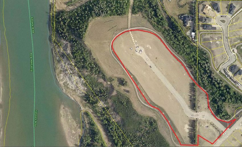
2019 Multi-Residential Land Assessment Methodology Page | 25 Study Area - Keswick Study Area - ICE Phase 2
2019 Multi-Residential Land Assessment Methodology Page | 26 Study Area - Armature
2019 Multi-Residential Land
Assessment Methodology Page | 27
Study Area - Jasper Avenue West
Measure Conversion Chart
Imperial to Metric – Length Imperial to Metric – Area
1 inch (in) = 2.54 centimetres (cm) 1 square foot (sqft) = 0.09290 square metre (m2)
1 foot (ft) = 0.3048 metres (m) 1 acre (ac) = 4,046.86 s quare metre (m2)
Imperial Conversions 1 acre (ac) = 0.40469 h
ectares (ha)
1 acre (ac) = 43,560 square feet (sqft) Metric Conversions
1 square mile = 640 acres (ac) 1 square kilometer (sq km) = 100 hectares (ha)
1 section = 640 acres (ac) 1 hectare (ha) = 10,000 square metres (m2)2019 Multi-Residential Land
Assessment Methodology Page | 28
Zone Summary
Residential
Residential Mixed Dwelling Zone (s.155) is to provide for a range of dwelling types
RMD
and densities including single detached, semi-detached and row housing
Row Housing Zone (s.160) s to provide for relatively low to medium density housing,
RF5
generally referred to as Row Housing
Urban Character Row Housing Zone (s.165) is to provide for medium density Row
UCRH Housing in a manner that is characteristic of urban settings and can include more
intensive development
Medium Density Multiple Family Zone (s.170) is to provide for medium density
RF6
housing, where some units may not be at Grade
RA7 Low Rise Apartment Zone (s.210) provides for low rise apartment buildings
RA8 Medium Rise Apartment Zone (s.220) provides for medium rise apartment buildings
RA9 High Rise Apartment Zone (s.230) provides for high rise apartment buildings
Rural Residential Zone (s.240) is to provide for single detached residential
RR development of a permanent nature in a rural setting, generally without the provision
of the full range of urban utility services
Residential Mixed Use Zone (s.910.10) is to provide for primarily medium to high
RMU density residential mixed-use developments, with limited commercial, institutional,
office and service Uses distributed on-site
Mobile Home Zone (s.250) is to provide for Mobile Homes developed within a Mobile
RMH
Home Park or Mobile Home Subdivision.
Urban Services
AJ Alternative Jurisdiction Zone (s.560)2019 Multi-Residential Land
Assessment Methodology Page | 29
Direct Control Provisions
Direct Development Control (s.710) is to provide for detailed, sensitive control of
the use, development, siting and design of buildings and disturbance of land where
this is necessary to establish, preserve or enhance:
DC1
a. areas of unique character or special environmental concern
b. areas or sites of special historical, cultural, paleontological, archaeological,
prehistorical, natural, scientific or aesthetic interest
Site Specific Development Control (s.720) is to provide for direct control over a
DC2 specific proposed development where any other Zone would be inappropriate or
inadequate.
Special Areas are areas with special or unique attributes, which cannot be satisfactorily addressed
through conventional land use zoning.
Special Area: Downtown
HA Heritage Area Zone (s.910.7) is to establish a special heritage character Zone, in which
the existing concentration of historical resources shall be preserved, rehabilitated and
reused, and to ensure new developments are pedestrian friendly and compatible
HDR High Density Residential Zone (s.910.8) is to accommodate high density housing with
minor local commercial uses in a predominantly residential environment and to
support the concept of a livable urban village with a strong sense of identity and place
RMU Residential Mixed Use Zone (s.910.10) is to provide for primarily medium to high
density residential mixed-use developments, with limited commercial, institutional,
office and service Uses distributed on-site in a manner sensitive to the street
environment and adjacent residential areas
UW Urban Warehouse Zone (s.910.11) is to develop a unique mixed-use business
commercial, educational and residential neighbourhood, accommodating a diversity of
uses
For additional zone details, refer to the Zoning Bylaw.You can also read