Nukuhau Structure Plan - Archaeological Assessment for the Nukuhau Structure Plan Change, Taupo 7 September 2021 - Taupo District Council
←
→
Page content transcription
If your browser does not render page correctly, please read the page content below
Project Number: 2-37400.00

Nukuhau Structure Plan
Archaeological Assessment for the
Nukuhau Structure Plan Change, Taupo
7 September 2021
Contact Details
                  Kirsty Sykes
                  WSP
                  19 Henry Street
                  Blenheim 7012
                  +64 3 520 9500
                  +64 21 243 2899
                  kirsty.sykes@wsp.com

                  Document Details:
                  Date: August 2021
                  Reference:    2-37400.00
                  Status: Final

                  Prepared by

                  Kirsty Sykes

                  Senior Archaeologist
                  Reviewed by

                  Nick Cable

                  Senior Archaeologist

©WSP New Zealand Limited 2021                i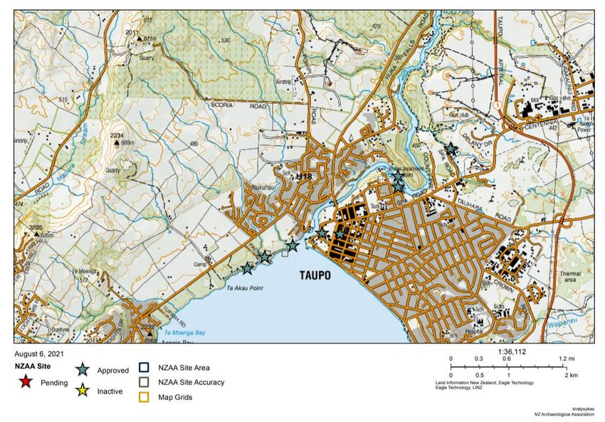
Project Number: 2/37400.00
Nukuhau Structure Plan:
Archaeological Assessment

Document History and Status
     Revision         Date          Author               Reviewed by        Approved by       Status
 1               05/08/2021      K. Sykes              N. Cable                           Draft 1
 2               24/08/2021      K. Sykes              N. Cable                           Draft 2
 3               27/8/2021       K. Sykes              N. Cable                           Final

Revision Details
     Revision                                                  Details
 1               Initial draft
 2               Initial reviewer amended comments
 3               Reviewer amended comments

Disclaimers and Limitations
This report (‘Report’) has been prepared by WSP exclusively for Lexus Trustees 11 Ltd, Dentistry
Revisited Ltd and CN Top Investment Ltd (‘Client’) in relation to the Nukuhau Structure Plan
Change Project (‘Purpose’). The findings in this Report are based on and are subject to the
assumptions specified in the Report. WSP accepts no liability whatsoever for any reliance on or
use of this Report, in whole or in part, for any use or purpose other than the Purpose or any use or
reliance on the Report by any third party.

In preparing the Report, WSP has relied upon data, surveys, analyses, designs, plans and other
information (‘Client Data’) provided by or on behalf of the Client. Except as otherwise stated in
the Report, WSP has not verified the accuracy or completeness of the Client Data. To the extent
that the statements, opinions, facts, information, conclusions and/or recommendations in this
Report are based in whole or part on the Client Data, those conclusions are contingent upon the
accuracy and completeness of the Client Data. WSP will not be liable in relation to incorrect
conclusions or findings in the Report should any Client Data be incorrect or have been concealed,
withheld, misrepresented or otherwise not fully disclosed to WSP.

                                            ©WSP New Zealand Limited 2021                              1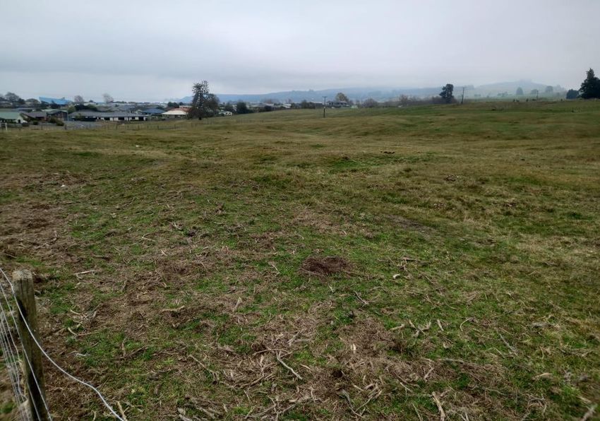
Project Number: 2/37400.00
Nukuhau Structure Plan:
Archaeological Assessment

Contents
Disclaimers and Limitations ................................................................................................................................................................................ 1

1            Introduction....................................................................................................................................................................................................... 4
             1.1          Purpose of this Report ............................................................................................................................................................... 4
             1.2          Site Location and Proposal .................................................................................................................................................... 4

2            Statutory Requirements ..........................................................................................................................................................................6
             2.1          The Heritage New Zealand Pouhere Taonga Act 2014 ..................................................................................6
             2.2          The Resource Management Act 1991.............................................................................................................................6

3            Methodology...................................................................................................................................................................................................... 7
             3.1          Sources of Information............................................................................................................................................................... 7
             3.2          Assessment of Effects..................................................................................................................................................................8

4            Constraints and Limitations .................................................................................................................................................................9

5            Environmental Setting..............................................................................................................................................................................9

6            Historic Background ...................................................................................................................................................................................9
             6.1          Pre-European Maori Archaeology..................................................................................................................................10
             6.2          Historic Archaeology ..................................................................................................................................................................10

7            Review of Information Sources........................................................................................................................................................10
             7.1          Recorded Archaeological Sites .........................................................................................................................................10
             7.2          Heritage Sites ................................................................................................................................................................................... 12
             7.3          Historic Survey Plans and Aerial Photography ................................................................................................... 12

8            Site Visit ................................................................................................................................................................................................................14
             8.1          Summary of Results.................................................................................................................................................................... 19

9            Assessment of Archaeological and Other Values ........................................................................................................... 19
             9.1          Archaeological Values ............................................................................................................................................................... 19
             9.2          Assessment of Heritage Values ...................................................................................................................................... 20

10           Assessment of Effects ............................................................................................................................................................................ 20
             10.1         Proposed Works........................................................................................................................................................................... 20
             10.2                       Potential Effects............................................................................................................................................................. 20

11           Conclusions and Recommendations ........................................................................................................................................ 21
             11.1         Recommendations...................................................................................................................................................................... 21

References ....................................................................................................................................................................................................................... 22

                                                                                            ©WSP New Zealand Limited 2021                                                                                                               2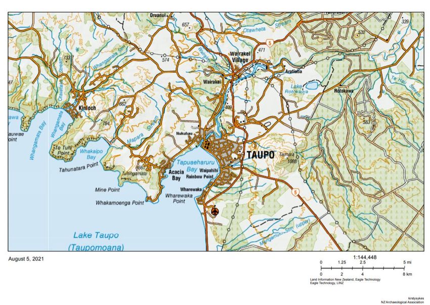
Project Number: 2/37400.00
Nukuhau Structure Plan:
Archaeological Assessment

List of Figures
Figure 1: Site location indicated by the red box. ............................................................................................................................... 4
Figure 2: Site with areas A, B and C indicated. Source: WSP ................................................................................................. 5
Figure 3: Archaeological site records (stars) within the vicinity of the proposed Site (red polygon).
Image from ArchSite. ............................................................................................................................................................................................... 11
Figure 4: A 1917 Māori Land survey showing Area A in part and indicating pine, manuka, fern
and a ‘deep gully’ (HNC ML 5271 G: Quickmaps). .......................................................................................................................... 12
Figure 5: Excerpt from ML5271 (1882) showing various place names and roads in the vicinity of
the lake front and Waikato River but outside the Site area (blue - source: QuickMap). .......................... 13
Figure 6: 1945 aerial photograph of the Site (indicated by the red polygon)........................................................ 13
Figure 7: View west of the southern portion of Area B. ............................................................................................................14
Figure 8: View west across the central portion of Area B. ...................................................................................................... 15
Figure 9: Typical stratigraphy in Area B; Thin topsoil overlaying a light brown tephra B horizon. .... 15
Figure 10: View south of Area C. ..................................................................................................................................................................... 16
Figure 11: Typical stratigraphy in Area C; Topsoil overlaying an orange tephra B horizon. ........................ 16
Figure 12: Locations of depressions within Area C (blue polygon). ................................................................................. 17
Figure 13: Locations of two depressions within Area C indicated by the red dashed circle..................... 17
Figure 14: Looking south at depression within Area C. .............................................................................................................18
Figure 15: Test pit dug within Figure 9 depression. ......................................................................................................................18

List of Tables
Table 1. Archaeological Values of pre-European pit site. ......................................................................................................... 19
Table 2. Statement of archaeological values for the site type pre-European Maori pits. ......................... 20

                                                                                     ©WSP New Zealand Limited 2021                                                                                                   3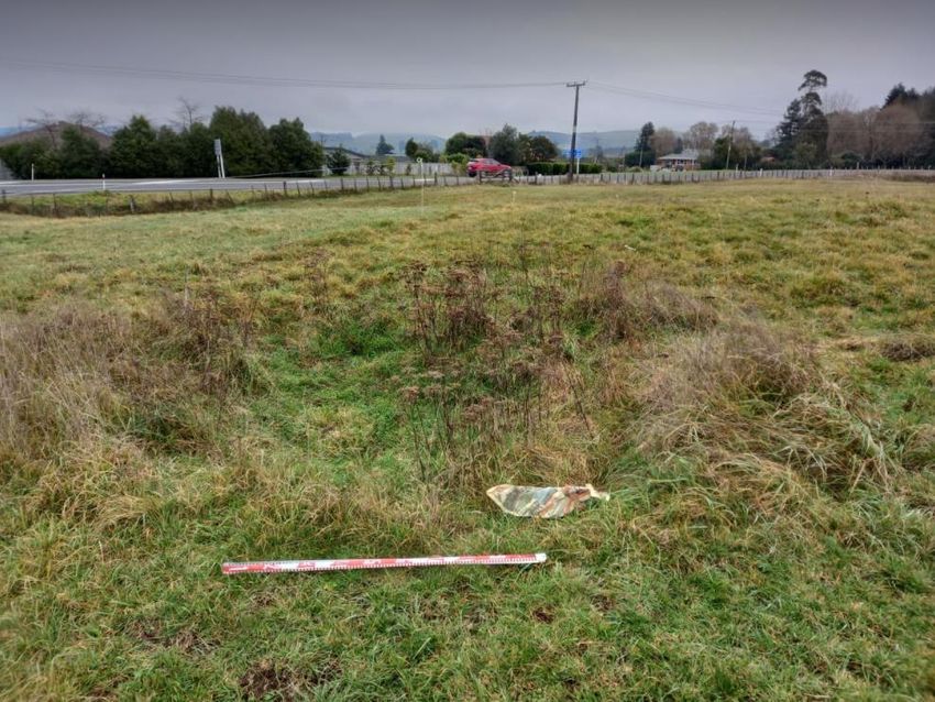
Project Number: 2-37400.00
Nukuhau Structure Plan:
Archaeological Assessment

1     Introduction
1.1   Purpose of this Report
Lexus Trustees 11 Ltd, Dentistry Revisited Ltd and CN Top Investment Ltd (the Client)
commissioned WSP to undertake an archaeological assessment for the proposed Nukuhau
Structure Plan Change in Taupo (see Figures 1 and 2). The plan change request seeks to change
the zoning of 77.76 hectares of Rural Environment zoned land to a mix of General Residential,
Medium Density Residential, Local Centre zoning and areas of stormwater and recreation reserves.
These proposed zone changes will enable the future development of approximately 780 dwellings
in an area identified in the Taupō District 2050 - Growth Management Strategy (TD 2050) as a
northern growth area. The area within Nukuhau to be affected by the Plan Change (the “Site”) is
located west of Taupo and currently comprises of farmland and fields mixed with lifestyle blocks.

This report presents an archaeological assessment of the effects of the Plan Change on the Site. It
evaluates the potential for archaeological sites to be present within the Site and assesses the
effects on archaeological values that the Plan Change and subsequent change in development
will have.

1.2   Site Location and Proposal
The Site is located on the western fringe of the Taupo residential area and the Waikato River
(Figure 1). The existing area is zoned for future suburban residential development, but the Plan
Change looks to amend the zoning to include general and medium density residential housing, a
neighbourhood shopping centre, as well as associated infrastructure including roads, services,
access paths, recreational areas and landscaping. For the purpose of this report, the Site area has
been split into three areas: A, B and C (Figure 2).

Figure 1: Site location indicated by the red box.

                                        ©WSP New Zealand Limited 2021                             4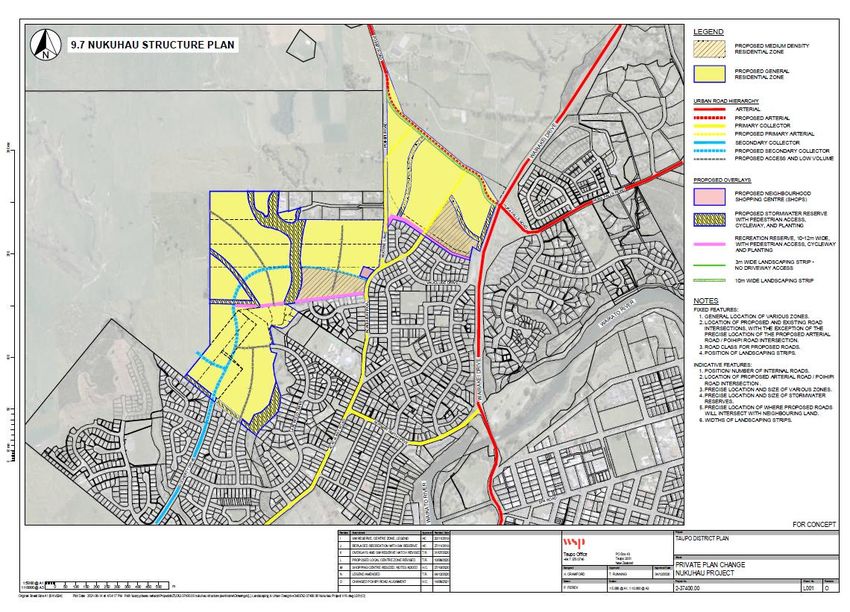
Project Number: 2-37400.00
Nukuhau Structure Plan:
Archaeological Assessment

                                                                      C

                                        B

                                    A

Figure 2: Site with areas A, B and C indicated. Source: WSP

                                      ©WSP New Zealand Limited 2021       5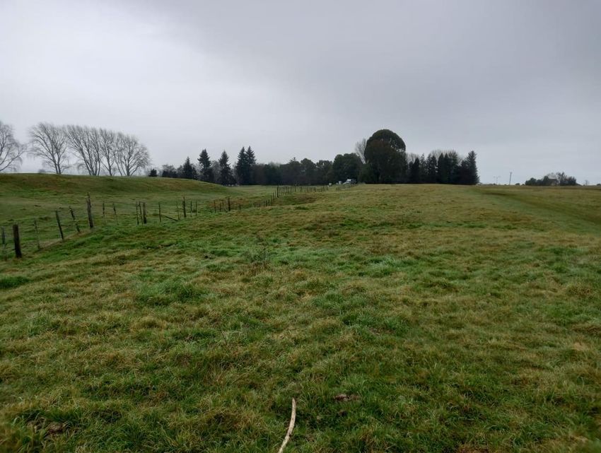
Project Number: 2-37400.00
Nukuhau Structure Plan:
Archaeological Assessment

2         Statutory Requirements
There are two main pieces of legislation in New Zealand that control work affecting archaeological
sites. These are the Heritage New Zealand Pouhere Taonga Act 2014 (HNZPTA) and the Resource
Management Act 1991 (RMA).

2.1       The Heritage New Zealand Pouhere Taonga Act 2014
The HNZPTA promotes the identification, protection, preservation, and conservation of the historic
and cultural heritage of New Zealand. It provides blanket protection to all archaeological sites
whether they are recorded or not. The provisions of the HNZPTA are administered by Heritage New
Zealand Pouhere Taonga (Heritage New Zealand). It is illegal to destroy, damage, or modify
archaeological sites without first gaining an archaeological authority to do so from Heritage New
Zealand.

The HNZPTA contains a consent (authority) process for any work affecting an archaeological site.
An archaeological site is defined under section 6 of the HNZPTA as: (a) any place in New Zealand,
including any building or structure (or part of a building or structure), that (i) was associated with
human activity that occurred before 1900, or is the site of the wreck of any vessel where the wreck
occurred before 1900; and (ii) provides or may provide, through investigation by archaeological
methods, evidence relating to the history of New Zealand; and (b) includes a site for which a
declaration is made under Section 43(1) of the Act.

Any person who intends carrying out work that may damage, modify or destroy an archaeological
site, or to investigate a site using invasive archaeological techniques, must first obtain an authority
from Heritage New Zealand. The process applies to sites on land of all tenure, including public,
private, and designated land. The HNZPTA contains penalties for unauthorised site damage or
destruction.

The archaeological authority process applies to all archaeological sites, regardless of whether:

      •    The site is recorded in the New Zealand Archaeological Association (NZAA) Site Recording
           Scheme (ArchSite) or included in the Heritage New Zealand List;

      •    The site only becomes known about as a result of ground disturbance; and/ or

      •    The activity is permitted under a district or regional plan, or a resource or building consent
           has been granted.

Heritage New Zealand also maintains the New Zealand Heritage List/ Rārangi Kōrero of Historic
Places, Historic Areas, Wāhi Tupuna and Wāhi Tapu Areas (the List). The List can include
archaeological sites.

2.2       The Resource Management Act 1991
Part II of the RMA outlines the Purpose and Principals of the RMA. In outlining the purpose of the
RMA, section 5 states:

      (1) The purpose of this Act is to promote the sustainable management of natural and physical
          resources.

      (2) In this Act, “sustainable management” means managing the use, development and
          protection of natural and physical resources in a way or at a rate, which enables the people
          and communities to provide for their social, economic, and cultural wellbeing and for their
          health and safety while-

                                           ©WSP New Zealand Limited 2021                                6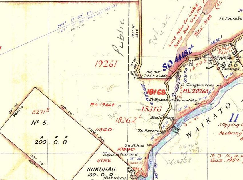
Project Number: 2-37400.00
Nukuhau Structure Plan:
Archaeological Assessment

                 a. Sustaining the potential of natural and physical resources (excluding minerals)
                    to meet the reasonably foreseeable needs of future generations; and

                 b. Safeguarding the life supporting capacity of air, water, soil and ecosystems; and

                 c.   Avoiding, remedying, or mitigating any adverse effects of activities on the
                      environment.

Section 6 of the RMA outlines that “in achieving the purposes of this Act, all persons exercising
functions and powers under it, in relation to managing the use, development, and protection of
natural and physical resources, shall recognise and provide for the following matters of national
importance.” The 2003 amendments to the RMA elevated historic heritage to a matter of national
importance under section 6(f), which identifies the need for “the protection of historic heritage
from inappropriate subdivision, use and development.”

A definition of historic heritage was also added with the amendments to the RMA. This defines
historic heritage as:

      a) Those natural and physical resources that contribute to an understanding and appreciation
         of New Zealand’s history and cultures deriving from any of the following qualities:

                      (i) archaeological;

                      (ii) architectural;

                      (iii) cultural;

                      (iv) historic;

                      (v) scientific;

                      (vi) technological; and

      b) Includes-

                      (i) Historic sites, structures, places and areas;

                      (ii) archaeological sites;

                      (iii) sites of significance to Māori, including wāhi tapu; and

                      (iv) surroundings associated with the natural and physical resources.

As such, when considering applications under the RMA, the consenting authority must recognise
and provide for historic heritage as a matter of national importance.

3         Methodology
3.1       Sources of Information
This assessment report is based on research from known information sources on archaeological
values and a field survey of the Site. Research was carried out using a range of information sources
including:

      •    New Zealand Archaeological Association (NZAA) Site Recording Scheme (ArchSite);

      •    New Zealand Heritage List/ Rarangi Kōrero;

      •    Previous archaeological reports and assessments;

                                            ©WSP New Zealand Limited 2021                           7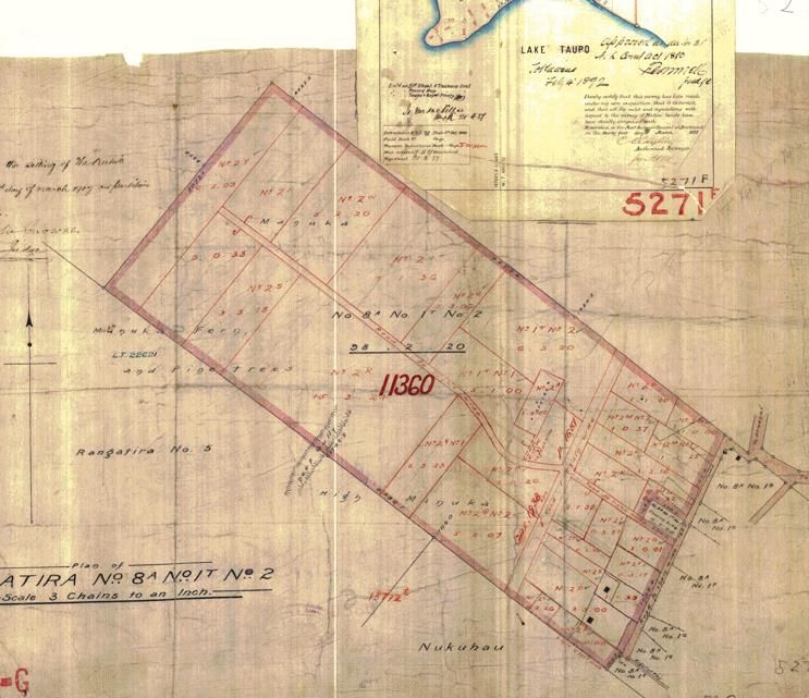
Project Number: 2-37400.00
Nukuhau Structure Plan:
Archaeological Assessment

      •    The District Plan;

      •    Aerial imagery; and

      •    Historic archives, web-based resources, maps and plans.

Senior Archaeologist Kirsty Sykes undertook a site visit on 6th July 2021 to inspect the Site. A site
walkover was undertaken, and a visual inspection of the surrounding ground was engaged in to
inspect any potential surface indicators of archaeological material.

Based on the information review and site walkover, it was possible to determine (a) whether any
archaeological sites are currently located within the Site; and (b) what potential types of
archaeological sites might otherwise exist.

3.2       Assessment of Effects

Criteria for Assessing Archaeological Values
Under the HNZPTA, archaeological assessments are directed to determine whether proposals
will directly impact archaeological sites and hence require an authority to modify or damage
archaeological sites from HNZPT.

HNZPT regards the following values as important in determining whether an authority can be
granted and what mitigation conditions should be attached to an authority decision (NZHPT
2019:9-10):

                i.    The condition of the site(s).
               ii.    Rarity: Is the site(s) unusual, rare or unique, or notable in any other way in
                      comparison with other sites of its kind?
              iii.    Does the site possess contextual value?
              iv.     Information Potential: What current research questions or areas of interest
                      could be addressed with information from the site(s)?
               v.     Amenity Value: Does the site(s) have potential for public interpretation and
                      education?
              vi.     Does the site(s) have any special cultural associations for any particular
                      communities or groups?

Criteria for Assessing Heritage Values
The RMA informs a prescriptive assessment process for determining environmental effects
(Schedule 5). As part of an Assessment of Environmental Effects (AEE), an assessment of heritage
effects must assess the effects of a proposal on the heritage values of recognised heritage sites
and identify appropriate mitigation or avoidance measures for these effects.

An Archaeological Assessment should consider both archaeological values relevant to the
HNZPTA authority process and heritage values relevant to RMA decision making in determining
effects on heritage values.

The RMA lists a number of qualities for assessing historic heritage in order to provide a robust
analysis to withstand, for example, Environment Court scrutiny.

There qualities are archaeological; architectural; cultural; historic; scientific; and technical (RMA
s2).

                                           ©WSP New Zealand Limited 2021                                8
Project Number: 2-37400.00
Nukuhau Structure Plan:
Archaeological Assessment
Section 66(3) of the HNZPTA lists criteria that should be used to assess the heritage significance
of a historic place:
a) The extent to which the place reflects important or representative aspects of New
Zealand history.
b) The association of a place with events, persons, or ideas of importance in New Zealand
history.
c) The potential of a place to provide knowledge of New Zealand history.
d) The importance of the place to tangata whenua.
e) The community association with, or public esteem for, the place.
f) The potential of the place for public education.
g) The technical accomplishment or value, or design of the place.
h) The symbolic or commemorative value of the place.
i) The importance of identifying historic places known to date from early periods of New
Zealand settlement.
j) The importance of identifying rare types of historic places.
k) The extent to which the place forms part of a wider historic and cultural area.
Section 66(4) and (6) provide that additional criteria may be prescribed by regulation.
4 Constraints and Limitations
The NZAA ArchSite was the primary resource used for identifying recorded sites in the area. It is
important to note that the archaeological site location data in ArchSite should be regarded as a
guide only and is generally based on reconnaissance rather than on accurate survey information.
The coordinates of many of the sites in the database are of variable accuracy. In addition to this,
the areal extents for many recorded sites are poorly defined.
This report does not include an assessment of Māori cultural values. Statements are made as to
the location and nature of archaeological sites and their archaeological values. There are no
statements on the cultural significance of the Site area nor are the views of tāngata whenua
represented in this report. An assessment of cultural significance will not necessarily correlate
with an assessment of the archaeological significance of the area.
5 Environmental Setting
The Site is located on the western edge of the Waikato River near its source at Lake Taupo. The
Site lies in the Taupo Volcanic Zone with its soils come from the pumice and ignimbrite rock
thrown out during the major Taupo eruptions (Forsyth and Aitken 1995:23).
The area is currently used as lifestyle blocks and for agricultural purposes on the western fridges
of the Taupo residential area. The majority of the Site is rolling volcanic hills and gullies in pasture
with patches of scrub.
6 Historic Background
No attempt is made here to synthesise the rich and detailed record of Māori oral traditions and
whakapapa concerning the area. Inexpert synthesis of information based on traditions and
whakapapa can be damaging to the interests of mana whenua. Therefore, such material is
©WSP New Zealand Limited 2021 9Project Number: 2-37400.00
Nukuhau Structure Plan:
Archaeological Assessment
omitted. Rather, the reader is referred to any records of Māori history where such information is
available.
6.1 Pre-European Maori Archaeology
Williams (1988) attempted to synthesise the data for the Lake Taupo area. The area hasn’t had
systematic archaeological survey and additions to the archaeological records since Williams work
have tended to have resulted from ad hoc archaeological records.
Williams concluded that early visits to the Lake Taupo district by early Maori were likely of a
temporary and/or seasonal nature with a greater dependence on forest resources then later in
the record. This occupation likely focused on the Waikato River and lake shores. Later settlement
of the area comprised primary and satellite settlements based on resource procurement with a
focus on the north, east and southern shores of the lake (Williams 1988 in Mallows 2007:16).
6.2 Historic Archaeology
The first European reached the Taupo district in the 1830s; mainly missionaries then traders and
scientific explorers (Greenfield 1996:9-10). The township area itself is reported to have been largely
unoccupied at that time (Campbell et al. 2013). There was limited interaction in the area
Europeans in the following decades until the arrival of the armed constabulary in 1869 when they
established a military post at the present day Taupo Reserve on the western edge of the current
Taupo CBD (Greenfield 1996:9-10; Mallows 2007:6-7). The Tapuaeharuru Redoubt was established
to protect the route between Napier and Taupo as well as being positioned at the strategic
convergence of several Maori tracks at the source of the Waikato River (Mallows 2007:7). The later
decades of the 19th century saw the slow development of the Taupo township and the town
continues to slowly grow with its primary attractions being forestry, agriculture, geothermal
energy and tourist attractions.
7 Review of Information Sources
7.1 Recorded Archaeological Sites
The ArchSite database holds information on all recorded archaeological sites; the database is
managed by the New Zealand Archaeological Association (NZAA).
A search of this database indicated that there are currently no recorded archaeological sites
within the Site area (Figure 3). Taupō is poorly represented in ArchSite, with the lack of recorded
sites indicative of a lack of systematic archaeological surveys. Those few recorded archaeological
sites within the wider area indicate both pre-European Māori and historic activity in the Taupō
township itself and along the margin of the lake and Waikato River. The closest recorded
archaeological sites record highly visible archaeological site including pa, urupa/cemetery and a
redoubt (e.g. U18/93; U18/87; U18/85; U18/2; U18/100; U18/97; U18/98). Currently the recorded
archaeological sites indicate a focus of activity around the lake and rivers, in other words, not
within the typological landscape in which the Site sits.
It is understood that the area around present day Taupō township, and the mouth of the Waikato
River, was strategically important to Māori and likely heavily occupied relative to surrounding
interior regions.
There are currently no relevant archaeological reports from previous archaeological
investigations that have been produced for the study area or in the immediate vicinity. A
summary of wider studies was included in the background section.
©WSP New Zealand Limited 2021 10Project Number: 2-37400.00
Nukuhau Structure Plan:
Archaeological Assessment
Figure 3: Archaeological site records (stars) within the vicinity of the proposed Site (red polygon). Image from ArchSite.
©WSP New Zealand Limited 2021 11Project Number: 2-37400.00
Nukuhau Structure Plan:
Archaeological Assessment
7.2 Heritage Sites
Review of Rārangi Korero / the New Zealand Heritage List and the Taupo District Plan indicated
that there are no historic places entered onto the list and plan in within or in close proximity to
the Site.
7.3 Historic Survey Plans and Aerial Photography
An examination of historic survey documents indicates that Area A of the proposed rezoning (as
identified in this document see Figure 1) was in pine plantation, fern and manuka in 1919 (Figure
4). While buildings and other features e.g. graves are marked on the plan, none are located
within the proposed Site area.
A number of Māori Land Court and other historic surveys were examined in relation to Areas B
and C, and whilst nothing of archaeological note was identified within the parcels, the presence
of pre-1900 pā and other named places were shown at the lake and river edge (Figure 5). This fits
with the known archaeological risk in those areas.
Review of historic aerial photography indicates the area was in pasture or scrub in 1945 with no
visible structures or modifications noted bar the occasional track (Figure 6). Aside from the
development of roads in the 1960s and small areas of disturbances, such as houses and quarrying
from the 1970s, the Site area has remained largely unmodified from the 1945 photograph.
A
Figure 4: A 1917 Māori Land survey showing Area A in part and indicating pine, manuka, fern
and a ‘deep gully’ (HNC ML 5271 G: Quickmaps).
©WSP New Zealand Limited 2021 12Project Number: 2-37400.00
Nukuhau Structure Plan:
Archaeological Assessment
Figure 5: Excerpt from ML5271 (1882) showing various place names and roads in the vicinity of
the lake front and Waikato River but outside the Site area (blue - source: QuickMap).
Figure 6: 1945 aerial photograph of the Site (indicated by the red polygon).
©WSP New Zealand Limited 2021 13Project Number: 2-37400.00
Nukuhau Structure Plan:
Archaeological Assessment
8 Site Visit
Kirsty Sykes (the author – Senior WSP Archaeologist) undertook a site visit to the Site on the 6th
July 2021. Area A was not inspected as access for the site visit was not provided.
A visual inspection of Area B was undertaken aside from the middle portion, which is in thick
scrub. Aside from the houses and outbuildings, the area inspected was primarily in short pasture
and stocked with sheep and horses (Figures 7 - 9). No archaeological features were noted during
the inspection.
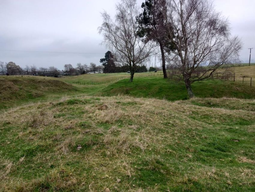
The visual inspection of Area C was undertaken with good visibility as the area was, for the
majority, in short pasture with grazing horses (Figurers 10-11). Two depressions, both
approximately rectangular and measuring up to 6 m were noted in close proximity in the
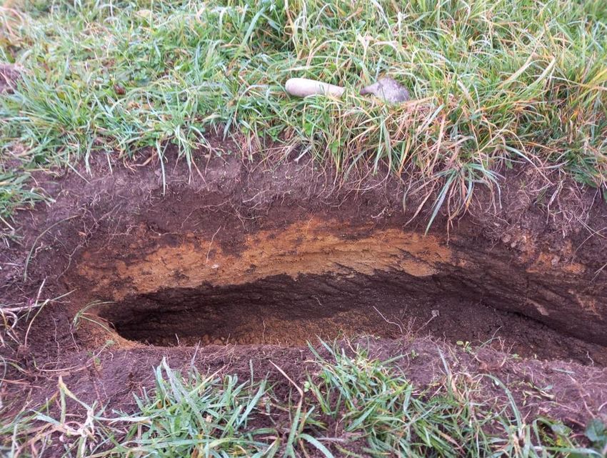
southern portion of Area A at E1866744 N5715213 (Figures 12- 14). A test pit was undertaken to a
depth of approximately 40cm in the larger of the depressions. The test pit indicated mixed A and
B horizon beyond the depth of the test pit indicating disturbance but was inconclusive as to the
source of this disturbance. A review of historic aerial photograph did not identify any potential
recent explanations for the depressions, such as trees etc. There is risk that these depressions
may represent archaeology features such as pits, however, further investigations would be
required to determine the actual nature of the depressions. No other features of archaeological
note were identified during the site visit.
Figure 7: View west of the southern portion of Area B.
©WSP New Zealand Limited 2021 14Project Number: 2-37400.00
Nukuhau Structure Plan:
Archaeological Assessment
Figure 8: View west across the central portion of Area B.
Figure 9: Typical stratigraphy in Area B; Thin topsoil overlaying a light brown tephra B horizon.
©WSP New Zealand Limited 2021 15Project Number: 2-37400.00
Nukuhau Structure Plan:
Archaeological Assessment
Figure 10: View south of Area C.
Figure 11: Typical stratigraphy in Area C; Topsoil overlaying an orange tephra B horizon.
©WSP New Zealand Limited 2021 16Project Number: 2-37400.00
Nukuhau Structure Plan:
Archaeological Assessment
Figure 12: Locations of depressions within Area C (blue polygon).
Figure 13: Locations of two depressions within Area C indicated by the red dashed circle.
©WSP New Zealand Limited 2021 17Project Number: 2-37400.00
Nukuhau Structure Plan:
Archaeological Assessment
Figure 14: Looking south at depression within Area C.
Figure 15: Test pit dug within Figure 9 depression.
©WSP New Zealand Limited 2021 18Project Number: 2-37400.00
Nukuhau Structure Plan:
Archaeological Assessment
8.1 Summary of Results
There are currently no recorded archaeological sites within the Site. The topography of the Site is
not located in the known high-risk archaeological zone for this area. However, the general area is
under recorded archaeologically due to a lack of systematic survey and the size of the Site area
and its general intactness increases the risk for potential archaeology. Two depressions in Area C
of the Project area require further investigation to determine if they are archaeological in nature.
Aside from this area of risk, the remainder of the Site is considered to have low archaeological
risk.
9 Assessment of Archaeological and Other Values
Archaeological values relate to the potential of a place to provide evidence of the history of New
Zealand. This potential is framed within the existing body of archaeological knowledge, current
research questions and hypotheses about New Zealand’s past.
Statements are made below in relation to the specific area within the Site that holds
archaeological potential. The majority of the Site is considered to be of low archaeological risk,
however, the two depressions within Area C may represent pits and are therefore assessed as a
potential site below.
9.1 Archaeological Values
Table 1. Archaeological Values of pre-European pit site.
Value Assessment
Unknown. No archaeological features but the two identified depressions
Condition appeared relatively intact and there is potential for additional intact
subsurface features to be present.
Any archaeological evidence identified in the risk zone of the depressions
and surrounds would be considered rare but not unique. The present of
Rarity/ pits suggests some form of settlement in this location, which is the first
Uniqueness such evidence. Other settlements in the area are documented, so overall
local significance here in potentially documenting a previously unrecorded
settlement opposite Taupo.
Depressions of an archaeological nature usually represent pits. These
Contextual Value would site within the context of the pre-European Maori landscape and
may be associated with gardening, storage and settlement.
If archaeological features are exposed there will be potential for scientific
information to be recovered by archaeological means related to:
Information - Māori subsistence practices,
Potential - Timing of site formation,
- Plant macrofossils and microfossils and microfauna can provide
paleoenvironmental evidence.
Low amenity value for the proposed plan change. However, during
proposed earthworks there may be opportunities for public information
Amenity Value and/or preservation should the depressions be confirmed as
archaeological.
Cultural Māori.
Associations
Overall Low - confirmation that these features are pits would lead to interpretation
Significance of this area as a settlement or gardening area, which is of local significance.
©WSP New Zealand Limited 2021 19Project Number: 2-37400.00
Nukuhau Structure Plan:
Archaeological Assessment
9.2 Assessment of Heritage Values
Table 4 below provides a summary of heritage values for the respective archaeology site type
described above. The assessment is based on the criteria outlined in Section 3.2.
Table 2. Statement of archaeological values for the site type pre-European Maori pits.
Qualities Assessment
Archaeological Low significance – no other recorded archaeological sites in this area
and further investigation needed to confirm the features as storage
pits. If confirmed then indicates a wider landscape of settlement or
gardening of local significance. Not currently confirmed or recorded as
an archaeological site but may represent pre-European Maori pits.
Architectural N/A
Cultural No published reference to settlement in this location, but if confirmed,
any archaeological evidence would have cultural significance to local
Māori as representing previous occupation site.
Historic Low – No known historical associations attached to this area and not
recognized as having any existing archaeological or heritage sites.
Scientific N/A
Technical N/A
OVERALL LOW HERITAGE VALUE – local significance only.
SIGNIFICANCE
10 Assessment of Effects
10.1 Proposed Works
The plan change request seeks to change the zoning of 77.76 hectares of Rural Environment zoned
land to a mix of General Residential, Medium Density Residential, Local Centre zoning and areas
of stormwater and recreation reserves. These proposed zone changes will enable the future
development of approximately 780 dwellings in an area identified in the Taupō District 2050 -
Growth Management Strategy (TD 2050) as a northern growth area.
The rezoning would allow wide scale development of the Site, involving extensive earthworks. This
report has been prepared to inform the project team of any archaeological concerns that need to
be taken into account as part of the Plan Change.
10.2 Potential Effects
Aside from the two depressions identified as having archaeological risk on Area C, the Site is
considered to have low archaeological risk. In both the existing zoning and proposed Plan Change,
development of the Site would require significant earthworks. There is no material difference in
regards to either zoning category as both would require development.
Given the low risk for archaeology across the majority of the Site and the low significance of the
potential archaeological site around the visible pits, development of the site for the Plan Change
or existing zoning designation is expected to have minor negative effects on archaeological values.
Mitigation of Effects
All pre-1900 archaeological sites are protected under the provisions of the HNZPTA, whether the
sites are recorded or not. It is illegal to destroy, damage, or modify archaeological sites without an
authority from HNZPT to do so.
©WSP New Zealand Limited 2021 20Project Number: 2-37400.00
Nukuhau Structure Plan:
Archaeological Assessment
Minor negative effects on archaeological values are typically mitigated by archaeological
investigation and recording under an HNZPTA authority. The majority of the Site is considered to
have low archaeological risk and thus, mitigation of archaeological values are, for the large part,
not required. The exception to this is the area identified above as having low archaeological risk
due to two depressions of an unknown origin. It is recommended that the minor effects of
development of this area can be mitigated through archaeological investigation and recording
under an HNZPTA authority.
On this basis, it is considered that the proposed Plan Change is an appropriate activity in regards
to archaeological effects.
11 Conclusions and Recommendations
This report has been prepared to assess the environmental effects of the Nukuhau Structure Plan
Change on archaeological values.
The majority of the Site is considered to have low archaeological risk and thus, low archaeological
values. The exception to this is the two depressions identified during the site visit in Area C. There
is potential that these may represent an unrecorded archaeological pit site, which in turn would
indicate wider settlement or gardening in the general vicinity. Any such evidence would be
considered of local archaeological relevance only and therefore is considered to be low
significance.
The proposed Plan Change and subsequent development of the site is expected to have minor
negative effects on archaeological values. These values can be mitigated through archaeological
investigation and recording under an HNZPT authority. Development under the existing
residential zoning designation has the same material effects so there no difference between the
proposed designations.
The Nukuhau Structure Plan change is considered appropriate from an archaeological
perspective, provided that the Archaeological Authority process is followed if required as per the
below recommendations.
11.1 Recommendations
The following recommendations are made in this report:
• Stakeholders should be made aware of the archaeological potential of the Site. This may
include, but is not limited to, the landowners, local iwi, Council and developers. The majority
of the Site, with the exception of the two depressions in Area C, is considered to have low
archaeological risk and low archaeological values;
• Further archaeological investigation should be undertaken as part of any future
development of the part of Area C containing the two depressions. An Archaeological
Authority should be sought from HNZPT for this work.
©WSP New Zealand Limited 2021 21Project Number: 2-37400.00
Nukuhau Structure Plan:
Archaeological Assessment
References
Campbell, M., Maguire, W., & J. Harris. 2013. The Spa Hotel, Taupo: Archaeological Assessment of
Standing Buildings and Management Plan. Unpublished report for Te Tikio Tamamutu Holdings
Ltd and New Zealand Historic Places Trust.
Forsyth, P. & J. Aitken. 1995. New Zealand Minerals and Rocks for Beginners. Institute Geological &
Nuclear Sciences Ltd, Lower Hutt.
Mallows, C. 2007. Tongariro Domain, Taupo: Riverside Park Development – Archaeological
Monitoring. Unpublished report for Opus International Consultants, Hamilton.
Survey Plan ML5271 – LINZ.
Williams, A. 1988: Land and Lake: Taupo Maori economy to 1860. Unpublished M.A. thesis,
Department of Anthropology, University of Auckland.
Greenfield, J.R. 1996. From Dust to Ashes: A Dynamic Community - A History of the Taupo District.
Publisher unspecified.
©WSP New Zealand Limited 2021 22wsp.com/nz
You can also read


