Pelican Rapids Bicycle and Pedestrian Plan January 29, 2021
←
→
Page content transcription
If your browser does not render page correctly, please read the page content below
Pelican Rapids Bicycle and Pedestrian Plan
            January 29, 2021

                                             0
Table of Contents

  1. Acknowledgements

  2. Executive Summary

  3. Background

  4. The Six “E” s

       a.   Equity
       b.   Engineering
       c.   Education
       d.   Encouragement
       e.   Engagement
       f.   Evaluation

  5. Supporting Documents

  6. Appendix – Speed Limit Articles

                                       1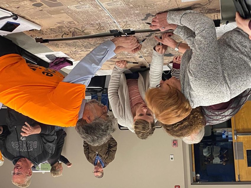
Acknowledgements
Sponsor: Blue Cross Blue Shield of Minnesota, Center for Prevention
Community Advisory Committee Members:

   •   Brent E. Frazier       Mayor, City of Pelican Rapids
   •   Don Solga              City of Pelican Rapids
   •   Brian Olson            City of Pelican Rapids
   •   Bob Schlieman          Apex Engineering
   •   Mary Safgren           MnDOT District 4
   •   Jane Butzer            MnDOT District 4
   •   Wayne Hurley           West Central Initiative
   •   Abdirashid B Dool      Multicultural Resource Center
   •   Kate Martinez          PR Schools/Park Board
   •   Rudy Martinez          Pelican Rapids Schools
   •   Miriam Perez           Pelican Rapids Resident
   •   Andrew Johnson         Local Business Owner
   •   Dave Ellison           Physician
   •   Gerry Langseth         The Welcome Place (Chair)
   •   Sheri O’Brien          PR Schools PE Teacher
   •   Rita Cowie             Sanford Health
   •   Jackie Larson          U of M Extension
   •   Deb Sjostrom           Local Resident
   •   Judy Engebretson       Park Board
   •   John Waller III        Planning Commission
   •   Dan Husted             Planning Commission
   •   Amy King               Park Board
   •   Van Holmgren           Park Board
   •   Dawn Jordan            Local Resident
   •   Jim Jordan             Local Resident
   •   Jeff McCracken         Local Resident
PartnerSHIP 4 Health Staff:

   •   Patrick Hollister
   •   Katie Kitowski         (Minnesota GreenCorps Member serving with PS4H)
   •   Jason Bergstrand
   •   Rory Beil

                                                                                2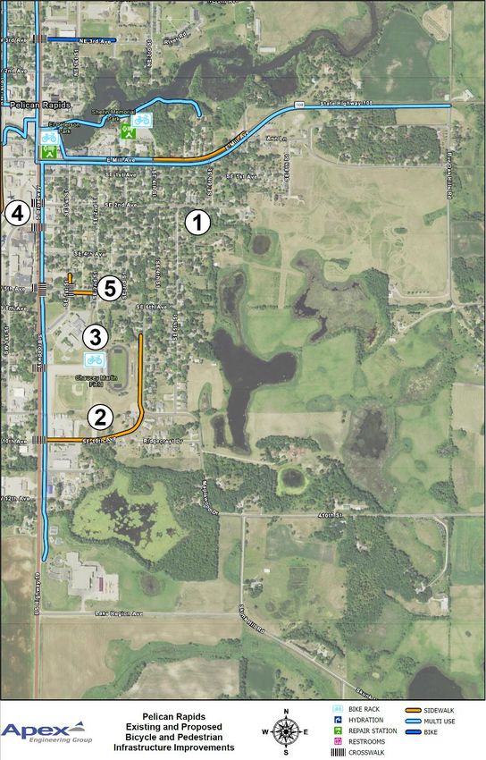
Executive Summary
The City of Pelican Rapids has several immediate opportunities to greatly improve the
community for biking and walking. These include MnDOT District 4’s reconstruction of
Highways 59 and 108 within city limits in 2024, the new trailhead at 108 Midway Avenue, the
decommissioning and removal of the Pelican Dam, and the construction of the Pelican Rapids-
to-Perham trail which includes a connection between Pelican Rapids and Maplewood State
Park.
   1. Highways 59 & 108 Reconstruction. The body that is primarily responsible for the
      redesign of Highways 59 and 108 within Pelican Rapids is known as the Project
      Management Team (PMT), convened and led by MnDOT District 4. Our Bicycle and
      Pedestrian Plan Community Advisory Committee, in writing this Plan, has largely
      deferred to the PMT regarding the design of Highways 59 and 108. Our plan does,
      however, urge both MnDOT District 4 and the City of Pelican Rapids to solicit as much
      community input regarding the redesign of 59 & 108 as possible, particularly from
      portions of the community that experience more challenges safely biking and walking.
      We also recommend that District 4 and the City use the 2024 reconstruction to
      maximize bicycle-friendliness, pedestrian-friendliness, and handicapped accessibility
      along and across 59 and 108.

   2. New Trailhead. With respect to the new trailhead at 108 Midway Avenue, we
      recommend that the City enhance this trailhead with a variety of user-friendly amenities
      to make it a welcoming transition point on and off the trails. These amenities could
      include restroom facilities, a drinking fountain, bike racks, picnic tables, benches, a self-
      service bike repair station (already funded by PartnerSHIP 4 Health), and a signature
      public art piece.

   3. Pelican Dam. The impact of the decommissioning and removal of the Pelican Dam on
      the river’s water level and boundaries is still undetermined, but these changes may well
      lend themselves to increased bicycle and pedestrian amenities. The City should take
      advantage of such opportunities if they exist.

   4. Pelican Rapids-to-Perham Trail. Segments of the Pelican-Rapids to Perham trail are
      already being funded and constructed. For the City of Pelican Rapids, the immediate
      benefit will be a safe route to walk or bike to Maplewood State Park. A continuous trail
      on which to bike all the way from Pelican Rapids to Perham is a longer-term goal. The
      City should continue to work with both Otter Tail County and MnDOT District 4 to make
      progress with trail funding and construction.
The are many other actions that we recommend the City take to further the cause of safe biking
and walking in the community. These actions are detailed throughout this document.
                                                                                                  3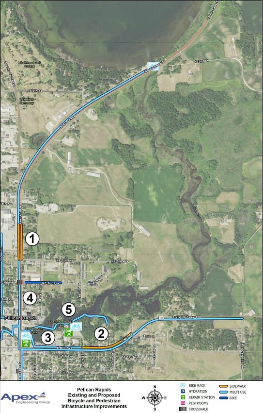
Background
MnDOT District 4 will be reconstructing Highways 59 and 108 within Pelican Rapids city limits in
2024. In anticipation of this project, PartnerSHIP 4 Health funded a public input process to
create a concept plan for how to improve 59 and 108 for biking, walking, and handicapped
accessibility in 2019. PartnerSHIP 4 Health hired SRF to facilitate the meetings and write the
concept plan, under the guidance of an advisory committee consisting mainly of local residents.
During the public input process for the concept plan, PartnerSHIP 4 Health received comments
from local residents about challenges with biking and walking elsewhere in the city, apart from
59 and 108. This inspired PartnerSHIP 4 Health to pursue funding to create a Bicycle and
Pedestrian Plan for the entire city. In the fall of 2019, PartnerSHIP 4 Health applied for and was
awarded a sponsorship from Blue Cross Blue Shield Center for Prevention to create the Bicycle
and Pedestrian Plan. Rather than hire a consultant, PartnerSHIP 4 Health decided to create the
plan in-house. Work on the Bicycle and Pedestrian plan was completed during calendar year
2020.
PartnerSHIP 4 Health and the City of Pelican Rapids formed a Community Advisory Committee
for the plan, which met multiple times during 2020. The original intent was for the Committee
to meet in-person on a bi-monthly basis throughout 2020. Soon after the first in-person
meeting of the Committee in February, however, the COVID-19 pandemic reached Minnesota.
Consequently, all further meetings of the Committee were online.
The pandemic also had significant impacts on the methodology for the Bicycle and Pedestrian
Plan. Prior to the pandemic, PartnerSHIP 4 Health had planned to take advantage of multiple
annual outdoor community festivals in Pelican Rapids, such as Pelican Fest, the Friendship
Festival, and Art in the Park, to disseminate information about the plan and to collect public
input for the plan. PartnerSHIP 4 Health had also planned to hold at least three in-person
public input meetings, most likely in the Community Meeting Room at Lake Region Electric
Coop. The pandemic required the community to cancel the annual festivals, and PartnerSHIP 4
Health’s planned public input meetings were held online. Nevertheless, we did get good public
input for the Bicycle and Pedestrian Plan, which has been incorporated into the Plan.
Patrick Hollister of PartnerSHIP 4 Health presented the final draft of the Bicycle and Pedestrian
Plan to the Pelican Rapids City Council at their regular meeting on December 8, 2020. Patrick
submitted the final Plan in PDF form to the City Administrator in January 2021. PartnerSHIP 4
Health will continue to be involved in the implementation of the Plan going forward.

                                                                                                    4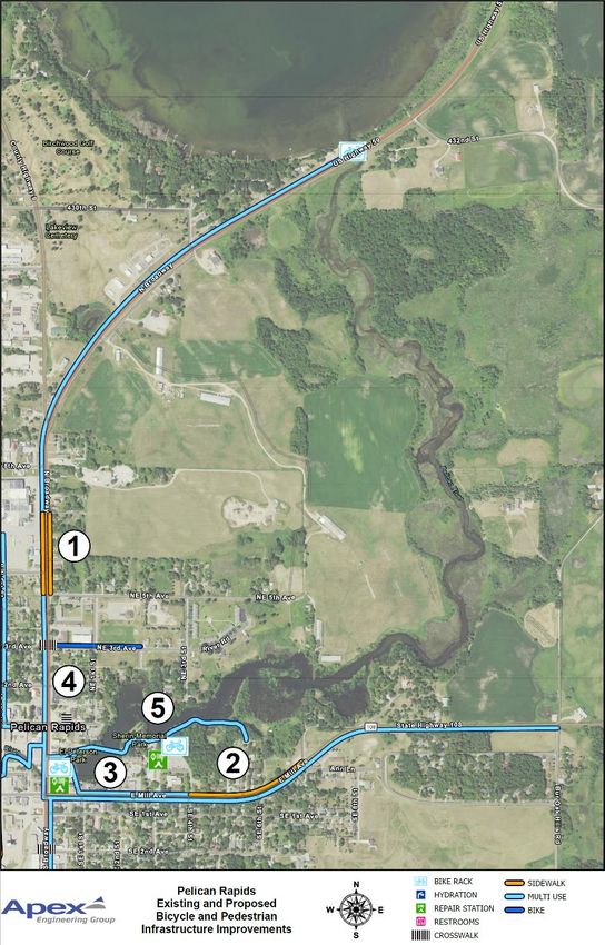
Planning Process Timeline

2020 Bicycle and Pedestrian Plan Committee Meetings
February 3 – City Hall
April 2 – Zoom
July 20 – Zoom
October 20 – Zoom

2020 Bicycle and Pedestrian Plan Public Input Meetings
June 23 and 29 (2) – Zoom
September 15, 22, and 23 – Zoom
November 16, 18, and 19 – Zoom

                                                         5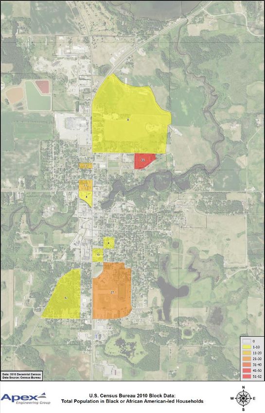
The Six “E” s
The Pelican Rapids Bicycle and Pedestrian Plan is organized around The Six “E”s, like many Safe
Routes to School plans on our region:
1) Equity. This plan is intended to help make Pelican Rapids more bicycle-friendly and
   pedestrian-friendly for all Pelican Rapids residents. We know, however, that in
   communities across the United States, there are certain groups within the population that
   typically face greater challenges being able to bike or walk safely in their neighborhoods
   than the majority population. This includes communities of color, immigrant communities,
   and people for whom English is a second language. With the above in mind, we have paid
   specific attention to the two neighborhoods in Pelican Rapids with the highest
   concentration of such populations: the Latinx neighborhood west of Highway 59, and the
   Somali neighborhood east of Highway 59.

2) Engineering. This “E” covers physical infrastructure that enables safer and easier biking and
   walking through the community. This “E” also covers planning for said infrastructure.

3) Education. This “E” covers any activity, whether by the school district or any other entity in
   the community, that furthers knowledge about biking or walking safely in Pelican Rapids.
   This can include not only education to bikers and walkers, but also education to drivers.

4) Encouragement. This is the fun “E”. This entails organizing and promoting biking- and
   walking-related events in the community. Fergus Falls is a good example of a neighboring
   community that routinely organizes biking-related events throughout the year. We have
   more detail about some of these events later in this document.

5) Engagement. This “E” refers to the Pelican Rapids Police Department’s role in helping to
   make the community more bicycle- and pedestrian-friendly. The police can play a role in
   outreach, safety education, and modeling positive behavior for residents. We explore this
   more later in the document.

6) Evaluation. This is often the most overlooked “E”. We provide recommendations below for
   evaluation of the community for biking and walking.

                                                                                                  6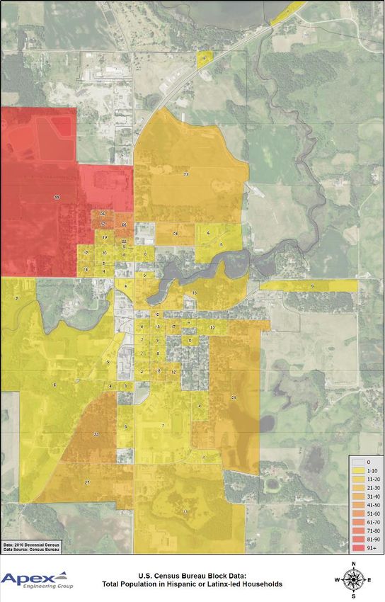
Equity
Pelican Rapids rightfully prides itself on being a culturally diverse community. The two largest
languages in Pelican Rapids, after English, are Spanish and Somali. In creating the Bicycle and
Pedestrian Plan, we looked specifically at how the Latinx and Somali populations are
geographically distributed within Pelican Rapids, based upon 2010 census data. (The 2020
census data will not be available until the summer of 2021.) We were curious about this
because in communities across the United States, immigrant populations often face additional
challenges being able to bike or walk safely in their neighborhoods. This is due to factors such
as a higher dependence on biking and walking due to lower car ownership, lack of bicycle and
pedestrian infrastructure in their neighborhoods, difficulty understanding the rules of the road
due to language challenges, etc.
These two maps show the geographic distribution of the Latinx and Somali populations within
Pelican Rapids as of 2010. As you can see, the Latinx population is most concentrated
northwest of the intersection of Highways 59 and 108, and the Somali population is most
concentrated northeast of the intersection of Highways 59 and 108.

                                                                                                   7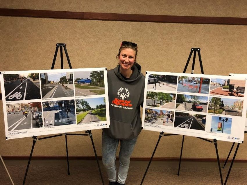
The neighborhood with the highest Latinx concentration is roughly bounded by Highway 59 on
the east, Highway 108 on the south, 3rd Street NW on the west, and West Central Turkeys on
the north. Many of the residents of this neighborhood work at West Central Turkeys, and so
one advantage that this neighborhood has is convenient walking proximity to the turkey plant.
This neighborhood, however, generally lacks sidewalks, and the few sidewalks that exist are
mostly either intermittent, in disrepair, or both.
The neighborhood with the highest Somali concentration is a townhome development known
simply as the “Townhomes of Pelican Rapids”. The development is bounded by River Road on
the south and east, NE 3rd Street on the west, and NE 5th Avenue on the north. Many of the
residents of this neighborhood also work at West Central Turkeys, and presumably use either
NE 5th Avenue or NE 3rd Avenue to get to the turkey plant. These two streets lack sidewalks for
most of the three blocks between the townhome development and Highway 59, and even
Highway 59 itself does not have complete sidewalks between NE 5th Avenue and the turkey
plant. Therefore, a resident of this townhome development walking to the turkey plant could
potentially face two safety hazards, particularly in winter: walking in the street between the
development and Highway 59, and then walking along Highway 59 to the turkey plant.
Fortunately, pedestrian improvements along Highway 59, including within the vicinity of the
turkey plant, are being planned as part of the 2024 reconstruction project. In April of 2020, the
City of Pelican Rapids also received a $550,000 Transportation Alternatives grant to help pay for
bicycle and pedestrian infrastructure improvements along Highways 59 and 108 in 2024. This
will help residents of the townhome development and other turkey plant employees walk
safely along Highway 59, but it will still leave the walk between the townhomes and Highway 59
potentially hazardous, particularly in winter.
Therefore, we are recommending that the City of Pelican Rapids take advantage of future
opportunities, such as road projects in both the Latinx and Somali neighborhoods, to improve
bicycle and pedestrian infrastructure, in consultation with the residents of these
neighborhoods. At first glance, it appears that the most pressing need in both neighborhoods
would be additional sidewalks, but this would need to be further investigated.
There are other Equity recommendations throughout the remaining five “E”s in this document.

                                                                                                8
Engineering
The following five maps depict infrastructure recommendations by the Bicycle and Pedestrian
Plan Advisory Committee. For convenience we have divided the City into quarters – Northwest,
Northeast, Southeast, and Southwest, using Highways 59 and 108 as boundaries.

                                                                                           9
Northwest Infrastructure
Recommendations
1. Sidewalk along the west side of
Broadway (59) from 5th to the
Turkey Plant.
2. Sidewalk along NW 1st Avenue
(108) from NW 3rd Street to the
new apartment complex.
3. Multi-use paths along Highways
59 & 108, NW 1st Street, leading
to the trailhead, and leading to
Peterson and Sherin Parks.
4. Bike infrastructure along NE 3rd
Avenue
5. Bike rack, restrooms, and
drinking fountain at the
trailhead.
6. Painted crosswalk across
Highway 59 at NE 3rd Avenue
10Northeast Infrastructure
Recommendations
1. Sidewalk on the east side of
Broadway (59) from 5th Avenue
NE to the turkey plant.
2. Sidewalk on the north side of
Highway 108 from SE 4th Street
to Ann Lane.
3. Multi-use paths along
Highways 59 and 108, and
between 59, Peterson Park,
and Sherin Park.
4. Bike infrastructure along NE 3rd
Avenue from 59 to NE 2nd
Street.
5. Bike racks and bike
maintenance stations at
Peterson Park and Sherin Park.
11Southeast Infrastructure
Recommendations
1. Sidewalk in the vicinity of SE
5th Street and SE 3rd Avenue.
2. Sidewalk along SE 10th
Avenue.
3. Bike rack at Chauncey Martin
Field
4. Painted crosswalks across
Highway 59 at SE 2nd Avenue,
SE 3rd Avenue, SE 5th Avenue,
Chauncey Martin Field, and SE
10th Avenue.
5. Painted crosswalk across SE
5th Avenue at Highway 59.
12Southwest Infrastructure
Recommendations
1. Sidewalk from trailhead to
Thompson Memorial Park.
2. Multi-use path from Highway
59 to trailhead.
3. Bike racks at trailhead and
Thompson Memorial Park.
4. Restrooms and drinking
fountain at trailhead.
5. Painted crosswalks across
Highway 59 at SE 2nd Avenue,
SE 3rd Avenue, SE 5th Avenue,
Chauncey Martin Field, and SE
10th Avenue.
6. Painted crosswalk across SE 5th
Avenue at Highway 59.
13Highways 59 and 108 Redesign
The body that is primarily responsible
for the redesign of Highways 59 and
108 within Pelican Rapids is known as
the Project Management Team (PMT),
convened and led by MnDOT District
4. Our Bicycle and Pedestrian Plan
Community Advisory Committee, in
writing this Plan, has largely deferred
to the PMT regarding the design of
Highways 59 and 108. To the right is
an example cross-section of Highway
59 from the 2019 Concept Plan, which
is subject to change over the course of
2021.
Our plan does, however, urge both MnDOT District 4 and the City of Pelican Rapids to solicit as
much community input regarding the redesign of 59 & 108 as possible, particularly from
portions of the community that experience more challenges safely biking and walking. We also
recommend that District 4 and the City use the 2024 reconstruction to maximize bicycle-
friendliness, pedestrian-friendliness, and handicapped accessibility along and across 59 and
108.
This is another photo from the
2019 Highways 59 and 108 Concept
Plan process. Pelican Rapids Park
Board Chair and local art teacher
Kate Martinez is standing between
two story boards. The board on the
left features photos of various
types of bicycle infrastructure from
other communities that could be
implemented on 59 and 108. The
board on the right has photos of
various examples of streetscape
amenities from other communities.
14Trailhead
During the 2020 process for creating the Bicycle and
Pedestrian Plan, the City Council designated four
parcels in Pelican Rapids as the official trailhead for
the Pelican Rapids to Perham Trail, and other potential
trails from Pelican Rapids to neighboring communities.
This map shows the four parcels.
The Pelican Rapids Park Board is now working on developing the trailhead with appropriate
amenities. The City has already applied for and received funding from PartnerSHIP 4 Health for
a 24-hour self-service bike maintenance station for the trailhead. There are also discussions
underway regarding restroom facilities. The trailhead site is very close to the Senior Center,
and it may be possible to arrange for trailhead users to access the restrooms in the Senior
Center. One challenge involved with this, however, is that currently there is no way to allow
the public access to the restrooms without allowing access to the rest of the building.
Remodeling the building to allow access to the restrooms while securing the rest of the building
is an option but would be expensive. Right now, the Park Board is assuming that they will have
to place portable restrooms at the trailhead starting in the summer of 2021 until a more
permanent solution can be achieved.
Other possible trailhead amenities under discussion include
bike racks, a drinking fountain, picnic tables, benches, and a
kiosk for wayfinding information. The Park Board is also
looking into the possibility of a signature art piece for the
trailhead, inspired by the “playsculpture” installed at the
Central Lakes Trailhead in Fergus Falls. This is a photo of the
playsculpture.
15Highway 59 Bridge
MnDOT District 4’s 2024 reconstruction of
Highways 59 and 108 within Pelican Rapids
city limits includes the Highway 59 bridge
over the Pelican River. Bridge inspectors
from MnDOT Central Office have determined
that the bridge is in good condition and does
not need replacing, although there may be
some minor changes to the surface of the
bridge.
During the process to create the Bicycle and
Pedestrian Plan, some Pelican Rapids
residents have expressed interest in replacing
the current railing with a more decorative or
attractive railing. MnDOT District 4 has told
the City that if they would be willing to
replace the bridge railing at the City’s own
expense, as long as the new railing meets
MnDOT’s safety standards. The current
estimate for replacing the bridge railing is
about $300/foot.
Replacing the railing would be expensive, but it represents an opportunity for a significant
aesthetic improvement to a very conspicuous feature of downtown Pelican Rapids. We
recommend that the City Council further investigate the possibility of replacing the existing
railing with a more attractive design.
The decommissioning and removal of the Pelican
Dam may have an impact on the water level
under the bridge. The Park Board has also
entertained the idea of a multi-use path running
under the bridge itself in order to provide a
seamless connection between the City’s main
parks for bicyclists and pedestrians without
having to contend with motor vehicle traffic on
Highway 59. More research would need to be
done on future water levels and the cost of such
infrastructure.
16Trail Loops
During the public input process for the Bicycle and Pedestrian Plan, Pelican Rapids residents
expressed interest in the creation of “loops” of a reasonable distance for biking and walking.
Two specific loops north of town emerged as key ideas. For convenience, we refer to them as
the “Small Loop” and the “Big Loop”.
Small Loop
The Small Loop would start at the Pelican Rapids Village historic
monument, run north along County Road 9, east along 430th Street,
south along Industrial Park Drive, and southwest along Highway 59,
for a total distance of 1.2 miles. Points of interest along the loop
include Birchwood Golf Course.
Big Loop
The Big Loop would start at the Pelican Rapids Village historic
monument, run north along County Road 9, east along 450th Street,
and southwest along Highway 59, for a total distance of 7.4 miles.
Points of interest along the loop include Birchwood Golf Course and
the Prairie Lake boat launch.
Neither loop currently has bicycle- or pedestrian-specific infrastructure. The City Council
declined an offer from MnDOT District 4 to build a trail along the west side of Highway 59 from
the vicinity of the turkey plant to the Prairie Lake boat launch in 2024 at the City’s own cost.
The City Council declined this offer mainly because of cost, and also because of concerns
expressed by the Minnesota DNR (who operates the boat launch) and the Prairie Lake
Association that a trail leading to and ending at the boat launch would be interpreted as an
invitation for people to walk or bike to the boat launch for the purpose of swimming, which is
prohibited. The City Council did, however, leave open the possibility of building this trail link in
the future as part of a larger loop. Therefore, we are recommending that the City Council
investigate the cost and funding opportunities for both the Small Loop and the Big Loop.
River Loop. Another idea that has emerged is a “River Loop” along the west side of the Pelican
River from Highway 59 east and eventually rejoining 59 further north. This would require
acquisition of easements from private property owners along the river.
17Bicycle Engineering Action Items
1) Maximize public input into the design for MnDOT District 4’s reconstruction of Highways 59
and 108 in 2024. Public input opportunities for this project will begin in 2021. District 4 and
the City should publicize these opportunities among Pelican Rapids residents as much as
possible, including targeted outreach to the Somali, Latinx, and other immigrant
populations.
2) Leverage MnDOT District 4’s 2024 project to maximize pedestrian-friendliness, bicycle-
friendliness, and handicapped accessibility along and across Highways 59 & 108. The City of
Pelican Rapids received a Transportation Alternatives grant in the amount of $550,000 for
pedestrian, bicycle, and handicapped accessibility enhancement of the 2024 project. The
City, in coordination with MnDOT, should use the grant funding for maximum benefit for
the community regarding the above.
3) Consider replacement of the existing railing on the Highway 59 bridge to a more attractive
railing. MnDOT Central Office has determined that the Highway 59 bridge is structurally
sound and does not need replacing in 2024. MnDOT District 4 will be resurfacing the
bridge, including possible restriping of the travel lanes. District 4 has indicated to the City of
Pelican Rapids that they would be willing to replace the railing on the bridge to a more
attractive railing at the City’s own cost. Otherwise the railing will remain as it is. The
current estimate for replacing the railing is about $300 per foot.
4) As part of the 2024 project, MnDOT District 4 and the City should increase the number of
painted crosswalks across both Highway 59 and Highway 108. Locations for additional
painted crosswalks that have already been identified by the Pelican Rapids Bicycle and
Pedestrian Plan Community Advisory Committee are shown on the map on page 9.
5) The City should develop the new trailhead at 108 Midway with amenities that are useful for
bicyclists and walkers.
6) The City, in coordination with MnDOT District 4 and Otter Tail County, should develop the
following routes north of town as “bicycle loops”:
a) “Small Loop”
b) “Big Loop”
Development of these loops could consist of the following stages:
a) “Bike Route” signage
18b) Painted on-road markings
c) Widened shoulders
d) Separated Multi-Use Paths
19Education
Electronic Kiosk
The Pelican Rapids Public Library has recently
installed an electronic information kiosk on
the outside of their building. This kiosk is free
and open to the public. The intent behind the
kiosk is to provide information to the
community in English, Spanish, and Somali.
PartnerSHIP 4 Health has already submitted
videos for the kiosk about bicycle safety. We
recommend that the community continue to
use this resource to provide important bicycle
and pedestrian safety information to the
community.
Bicycle Education Action Items
1) After the COVID-19 pandemic ends, the City should hold a bike rodeo at the elementary
school, distribute free helmets to kids, and provide bike safety education information. This
annual event is already occurring in many communities in the region, including Detroit
Lakes and Fergus Falls. PartnerSHIP 4 Health and West Central Initiative would be willing to
help coordinate this event.
2) The City should help promote the weekly free bike maintenance that is already occurring
during the warm weather months.
3) The Pelican Rapids School District should teach the Walk! Bike! Fun! curriculum in the
schools. The first step would be to send a local educator to a Walk! Bike! Fun! Curriculum
training.
4) The City should distribute new Smart Cycling materials around the city (churches, mosque,
turkey plant, library, schools-- include materials that have been translated into Spanish and
Somali.)
20Encouragement
Bicycle Tourism
Bicycle tourism is a potential growth sector
for the Pelican Rapids economy. Pelican
Rapids is already a popular stop for people
biking in our region, for example from Fergus
Falls to Fargo. People biking across the
United States also sometimes stop in Pelican
Rapids. Several projects are underway that
have the potential to make Pelican Rapids
even more of a cycling destination, such as
the Pelican Rapids-to-Perham Trail and the
new trailhead. We recommend that the City
continue to focus on ways to increase bike
tourism in Pelican Rapids.
This is a map of the Adventure Cycling Route
Northern Tier in the proximity of Pelican Rapids.
While the route does not pass through Pelican
Rapids, cross-country cyclists often vary from
the official route and stop in Pelican Rapids.
MnDOT Districts 3 and 4 will be determining the
alignment of the new US Bike Route 20 in 2021-
2022. US Bike Route 20 will go from Saint Cloud
to Fargo. It is already anticipated that the route
will use the existing Lake Wobegon Trail and
Central Lakes Trail between Saint Cloud and
Fergus Falls. We recommend that Pelican
Rapids advocate for its inclusion in the US Bike
Route 20 alignment.
21Encouragement Action Items
1) Since the City has now received Honorable Mention as a result of its Bicycle-Friendly
Community application, review the recommendations from the League of American
Bicyclists and determine which items to implement. The City of Pelican Rapids can then re-
apply for the Bicycle-Friendly Community award from the League of American Bicyclists
with the assistance of PartnerSHIP 4 Health and/or West Central Initiative.
2) Include kids on bikes in the annual parade.
3) The City should promote the following annual national/international bike events:
a) April 30 Days of Biking
b) National Bike Month
c) National Bike Week
d) National Bike to Work Day
e) World Car-Free Day
f) International Walk to School Day
g) International Bike to School Day
4) The City should encourage local businesses to work towards becoming Bicycle Friendly
Businesses. West Central Initiative and PartnerSHIP 4 Health have a lot of experience
helping organizations apply for and receive the BFB award in our region, and they would be
happy to help organizations in Pelican Rapids apply for the award as well.
225) Organize a regularly scheduled community ride. This could resemble the annual Mayor’s
ride in Fergus Falls.
6) Hold adult learn to ride classes, including classes geared towards new immigrants in
community
7) Have a bikeshare/ bike checkout program at the library.
23Engagement
Prior to the 2019 Minnesota state legislative session, speed
limits on local streets in municipalities across Minnesota
were defined as 30 MPH unless posted otherwise. Cities
needed authorization from the state to lower the speed
limits on local streets, and approval was rare except for
streets close to schools. In 2019, the legislature made the
process much easier for cities to lower the speed limit on
local streets from 30 MPH to 20 MPH, and the cities of
Minneapolis and Saint Paul have already done so. (Note this
only applies to local streets that a city has jurisdiction over,
and does not include state roads, county roads, or
Municipal State Aid streets.) We recommend that the City
of Pelican Rapids investigate the possibility of lowering the
speed limit on local streets from 30 MPH to 20 MPH.
Engagement Action Items
Short Term
• Increase traffic enforcement on Maplewood Drive SE.
• Hold a bike rodeo at the elementary school. Hand out free helmets and provide bike
safety education information
• Hold a bike maintenance event with community education.
• Work with State Farm to hold a 55 Alive bike education event.
• Put up “Pedestrian Friendly Street” signage
• Have the local police department patrol on bicycle.
• Teach Walk! Bike! Fun! Curriculum in schools. Send a local educator to a Walk! Bike!
Fun! Curriculum training.
• Distribute new Smart Cycling materials around the city (Churches, Mosque, turkey plant,
library, schools-- include materials that have been translated into Spanish and Somali).
24Medium to Long-Term
• Grow the bike maintenance program.
• Hold a bike swap event.
• Hold bike education event at the free Family Movie Night
• Table at community festivals.
• Local police: Reward kids who are biking
25Evaluation
Bicycle Evaluation & Planning Action Items
Short-Term
• Promote bike repair, plan for other locations for stations. Include instructions and
information in multiple languages
• Safe Route to School Plan: apply for a future round of planning assistance funding from
MnDOT
• Connect with regional Toward Zero Deaths organization
• Plan for additional bike parking locations
• Continue to apply for the Bicycle Friendly Community program, and identify potential
Bicycle Friendly Businesses
Medium-to-Long Term
• Develop an ADA compliance plan
• Plan for trailhead locations and wayfinding signage/ kiosk, plan for other corridors
• Create a winter and street maintenance plan for bikes (ongoing)
• Plan for a roundabout at Highway 59 and County Road 9 intersection
26Supporting Documents
https://drive.google.com/drive/folders/1JdBnqsy8pbExD4p9VtwjotQZK58bVRvd?usp=sharing
• District 4 Bicycle Plan (2019)
• Minnesota Walks (2016)
• Pelican Rapids to Perham Regional Trail Plan (2014)
• Otter Tail County Trail Master Plan (2017)
• Pelican Rapids Comprehensive Plan (2014)
• Minnesota Statewide Bicycle System Plan (2016)
• Pelican Rapids Safe Routes to School Study (2008)
• Minnesota Bicycle Facility Design Manual (2020)
27Appendix
Links to articles regarding speed limits in Minnesota:
The speed limit on Minneapolis streets is now officially 20 mph
https://bringmethenews.com/minnesota-news/the-speed-limit-on-minneapolis-streets-is-now-
officially-20-mph
New 20 mph speed limits take effect in St. Paul, Minneapolis
https://www.twincities.com/2020/10/13/new-20-mile-per-hour-speed-limits-take-effect-in-st-
paul-minneapolis/
Cities of Minneapolis, Saint Paul announce new, lower speed limits
http://news.minneapolismn.gov/2020/03/12/cities-minneapolis-saint-paul-announce-new-
lower-speed-limits/
Focus on New Laws: Cities Authorized to Set Certain Speed Limits
https://www.lmc.org/news-publications/news/all/speed-limits-new-law/
28You can also read