Mt Gilead Koala Carrying Capacity Assessment - Prepared for Lendlease Communities (Figtree Hill) Pty Limited
←
→
Page content transcription
If your browser does not render page correctly, please read the page content below
Mt Gilead Koala Carrying Capacity Assessment
Prepared for Lendlease Communities (Figtree Hill) Pty Limited

© ECO LOGICAL AUSTRALIA PTY LTD                             1
Mt Gilead Koala Carrying Capacity Assessment | Prepared for Lendlease Communities (Figtree Hill) Pty Limited

DOCUMENT TRACKING
 Project Name               Mt Gilead Koala Carrying Capacity Assessment

 Project Number             15054

 Project Manager            Robert Humphries

 Prepared by                Robert Humphries

 Reviewed by                Dr Steven Ward, EMM Consulting

 Approved by                Robert Humphries

 Status                     Final

 Version Number             Ver 4

 Last saved on              3 March 2020

This report should be cited as ‘Eco Logical Australia 2020. Mt Gilead Koala Carrying Capacity Assessment. Prepared for
Lendlease Communities (Figtree Hill) Pty Limited.’

ACKNOWLEDGEMENTS
This document has been prepared by Eco Logical Australia Pty Ltd with support from Mark Anderson and Taylor Paynter of
Lendlease Communities

Disclaimer
This document may only be used for the purpose for which it was commissioned and in accordance with the contract between Eco Logical
Australia Pty Ltd and Lendlease Communities (Figtree Hill) Pty Limited. The scope of services was defined in consultation with Lendlease, by
time and budgetary constraints imposed by the client, and the availability of reports and other data on the subject area. Changes to available
information, legislation and schedules are made on an ongoing basis and readers should obtain up to date information. Eco Logical Australia
Pty Ltd accepts no liability or responsibility whatsoever for or in respect of any use of or reliance upon this report and its supporting material
by any third party. Information provided is not intended to be a substitute for site specific assessment or legal advice in relation to any
matter. Unauthorised use of this report in any form is prohibited.
                                                                                                                                           Template 2.8.1

© ECO LOGICAL AUSTRALIA PTY LTD                                                                                                                             i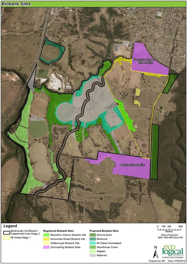
Mt Gilead Koala Carrying Capacity Assessment | Prepared for Lendlease Communities (Figtree Hill) Pty Limited

Contents

1. Introduction ............................................................................................................................... 1
2. Methodology .............................................................................................................................. 8
3. Results .......................................................................................................................................17
4. Discussion ..................................................................................................................................23
5. References ................................................................................................................................24
Appendix A : Arborsafe Tree Assessment Report ............................................................................25
Appendix B : Dr Steven Ward’s review of draft carrying capacity report ..........................................25

List of Figures

Figure 1: Mt Gilead Stage 1 and Stage 2 study area boundaries ............................................................... 3
Figure 2: Mapped vegetation types and condition in approved Mt Gilead Stage 1 .................................. 4
Figure 3: Mapped vegetation types and condition in proposed Mt Gilead Stage 2 .................................. 5
Figure 4: Impacted, retained and conserved Koala habitat Mt Gilead Stages 1 and 2 .............................. 6
Figure 5: Registered and proposed Biobank sites Mt Gilead Stages 1 and 2 ............................................. 7
Figure 6: Koala carrying capacity – current land management and loss of trees .................................... 19
Figure 7: Relative contribution of roadkill, tree loss and development to Koala numbers over 25 years
.................................................................................................................................................................. 20
Figure 8: Increase in Koala carrying capacity with management of on-site and off-site offset areas ..... 21
Figure 9: Change in total Koala carrying capacity following development and land management......... 22

List of Tables

Table 1: Area and condition of Koala habitat – Mt Gilead Stage 1 (MDP Lands)..................................... 11
Table 2: Area and condition of Koala habitat – Mt Gilead Stage 2 (Balance Lands) ................................ 12
Table 3: Allocation of Koala densities to different condition vegetation in impact areas ....................... 14
Table 4: Allocation of Koala densities to different condition vegetation in offset and open space areas
and changes in density over 25 years resulting from restoration and management .............................. 14
Table 5: Predicted Koala carrying capacity before and after development/conservation management
Years 1-25 ................................................................................................................................................. 18

© ECO LOGICAL AUSTRALIA PTY LTD                                                                                                                                    ii
Mt Gilead Koala Carrying Capacity Assessment | Prepared for Lendlease Communities (Figtree Hill) Pty Limited

Abbreviations

 Abbreviation               Description

 APZ                        Asset Protection Zone

 AW                         Alluvial Woodland

 BCAA                       Biodiversity Certification Assessment Area

 CCC                        Campbelltown City Council

 CKPoM                      Comprehensive Koala Plan of Management

 CPW                        Cumberland Plain Woodland

 DNG                        Derived Native Grassland

 DNS                        Derived Native Shrubland

 DPI&E                      NSW Department of Planning, Industry and Environment (formerly NSW Department of
                            Planning and Office of Environment and Heritage)

 ELA                        Eco Logical Australia Pty Ltd

 GIS                        Geographic Information System

 GMGA                       Greater Macarthur Growth Area

 GMDR                       Grey Myrtle Dry Rainforest

 LGA                        Local Government Area

 Lendlease                  Lendlease Communities (Figtree Hill) Pty Ltd

 NSW                        New South Wales

 PCT                        Plant Community Type

 RFEF                       River-flat Eucalypt Forest

 SCKHCS                     South Campbelltown Koala Habitat Connectivity Study

 SHW                        Shale Hills Woodland (a component of CPW)

 SPW                        Shale Plains Woodland (a component of CPW)

 SPT                        Scattered Paddock Trees

 SSTF                       Shale Sandstone Transition Forest

© ECO LOGICAL AUSTRALIA PTY LTD                                                                                                               iii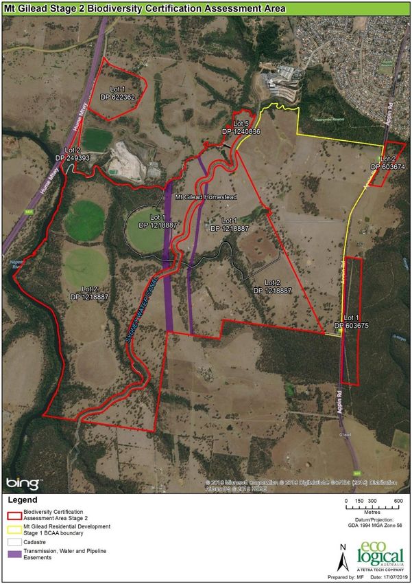
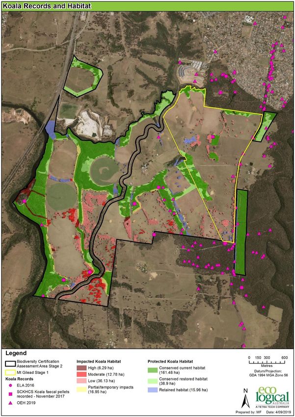
Mt Gilead Koala Carrying Capacity Assessment | Prepared for Lendlease Communities (Figtree Hill) Pty Limited

1. Introduction

Mt Gilead is a 881.5 ha rural property near the southern boundary of the Campbelltown Local
Government area that has been used extensively for grazing and cropping since the mid 19 th century
(Figure 1).

The property currently comprises predominantly cleared paddocks with scattered/isolated paddock
trees and improved grazing pastures, some larger copses of highly modified remnant woodland which
has been under-scrubbed and/or grazed, and relatively intact vegetation within drainage lines. The
remaining vegetation comprises Cumberland Plain Woodland (CPW) and Shale Sandstone Transition
Forest (SSTF) with the dominant tree species being Forest Red Gum (Eucalyptus tereticornis), Grey Box
(E. moluccana), Spotted Gum (Corymbia maculata) Grey Gum (E. punctata), White-stringybark (E.
globoidea) and Broad and Narrow-leaved ironbark (E. crebra and E. fibrosa) (Figures 2 and 3).

Koalas have been recorded on the property at low densities and it has been assumed that all treed
vegetation zones are habitat for the Koala (Figure 4), including scattered paddock trees (SPTs) and
patches of sparse, grazed woodland with low proportions of preferred Koala browse species (i.e. areas
dominated by high density of ironbark species and Spotted Gum which are not preferred browse species
in the region).

There are several Koala roadkill records along Appin Road on the eastern boundary of the property
where Koalas are likely using habitat resources on both the eastern and western sides of Appin Road. In
2018, local media (Liverpool City Champion, Macarthur Advertiser and St George Leader) and
representatives of environmental and wildlife carer groups (Sharyn Cullis – Gorges River Alliance and
Ricardo Lonza – wildlife carer) stated that there were 27 Koala road kills along Appin Road between 2012
and 2019 (an average of three to four per year). Crowther (2018) reported three road kills in 20016, six
in 2017 and eight between St Helens Park and the Beulah Biobank sites (south of Mt Gilead) in the six
months to 28 June 2018. The wildlife carers also stated that this was just the number of road kills that
had been reported to them and it was therefore likely a minimum figure. Indeed, the Atlas of NW
Wildlife and DPI&E (2019) show a concentration of Koala roadkill between Noorumba Reserve and
Beulah.

Consulting arborists, ArborSafe, undertook an assessment of 1,104 of the remnant paddock trees in
2017 (Arborsafe 2017 – Appendix A) and found a significant number of the trees to be senescent
(reflecting the history of land use on the property i.e. clearing for grazing and cropping with little to no
tree regeneration in operational parts of the property). Nearly 20% of these trees were assessed as
having a life expectancy of 0-10 years. Without a change in land management, the loss of trees is
expected to continue at an average of 2% per year.

In June 2019, the NSW Government conferred biocertification over an area of approximately 165 ha at
Gilead (Mt Gilead Stage 1) which included impacts to 10.79 ha of Koala habitat and required the
permanent protection of 22.49 ha of Koala habitat on-site in three Biobank sites adjacent to Noorumba
Reserve and Woodhouse Creek (ELA 2018) (Figure 4). A further 42.4 ha of Koala habitat has also been
secured at Noorumba Reserve and West Appin by the retirement of 301 Koala species credits.

© ECO LOGICAL AUSTRALIA PTY LTD                                                                                                             1
Mt Gilead Koala Carrying Capacity Assessment | Prepared for Lendlease Communities (Figtree Hill) Pty Limited

In August 2019, Campbelltown City Council (Council) submitted an application for biocertification over
a further 332.17 ha (Mt Gilead Stage 2), which includes impacts to an additional 72.22 ha of potential
Koala habitat and the protection and restoration of a further 201.81 ha of habitat on-site in five biobank
sites and 70-80 ha off-site (Figure 1, 4 and 5 and Table 1 and Table 2) (ELA 2019).

The Stage 2 proposal also includes provisions for wildlife exclusion fencing and a fauna underpass along
Appin Rd (subject to RMS approval) to reduce the current rate of Koala roadkill and improve connectivity
and gene flow between the eastern and western parts of the local koala population.

This report provides an assessment of the Koala carrying capacity of the Mt Gilead property prior to the
commencement of any development/habitat clearing and an estimate of the carrying capacity at the
conclusion of development (in approximately 25 years’ time or 2044). The assessment takes into
consideration the expected on-going deterioration of Koala habitat on the property without
development (i.e. as a rural property without active conservation management), the predicted loss of
senescing trees as determined by the arborists assessment and the loss of Koalas through vehicle strike
on Appin Road. The report also predicts the increase in Koala carrying capacity as a result of the
restoration and in perpetuity management of Koala habitat in the proposed offset and open space areas
which are expected to lead to an improvement in habitat quality over time and reduction of threats by
the implementation of a Koala Management Plan and a long term monitoring program.

Dr Steven Ward, a recognised Koala expert with considerable knowledge of the Campbelltown Koala
population was independently commissioned to review the assumptions and estimated Koala carrying
capacity data in an earlier version of this report. Dr Ward made a number of comments about further
justifying the predicted carrying capacity in different ages of regrowth and providing references, where
possible to substantiate the estimates. Dr Ward also questioned the justification for the average Koala
density in intact woodland/remnants to increase above the current maximum density used in proposed
offset areas and suggesting separating the annual loss of Koalas from road mortality from carrying
capacity (as road mortality does not affect habitat quality or carrying capacity, but local Koala numbers).

These suggestions have been incorporated into this final report with reference to a number of studies
in New South Wales and Queensland that have demonstrated the use of young (4-7 year old) plantations
on rural land by Koalas and further qualifications that the density estimates used in each age class of
regrowth are a conservative estimate of expected use to illustrate likely changes in carrying capacity
under prosed management scenarios rather than a definitive statement of actual future densities or
number of Koalas.

Dr Wards review is provided as Appendix B.

© ECO LOGICAL AUSTRALIA PTY LTD                                                                                                             2
Mt Gilead Koala Carrying Capacity Assessment | Prepared for Lendlease Communities (Figtree Hill) Pty Limited

Figure 1: Mt Gilead Stage 1 and Stage 2 study area boundaries

© ECO LOGICAL AUSTRALIA PTY LTD                                                                                                               3
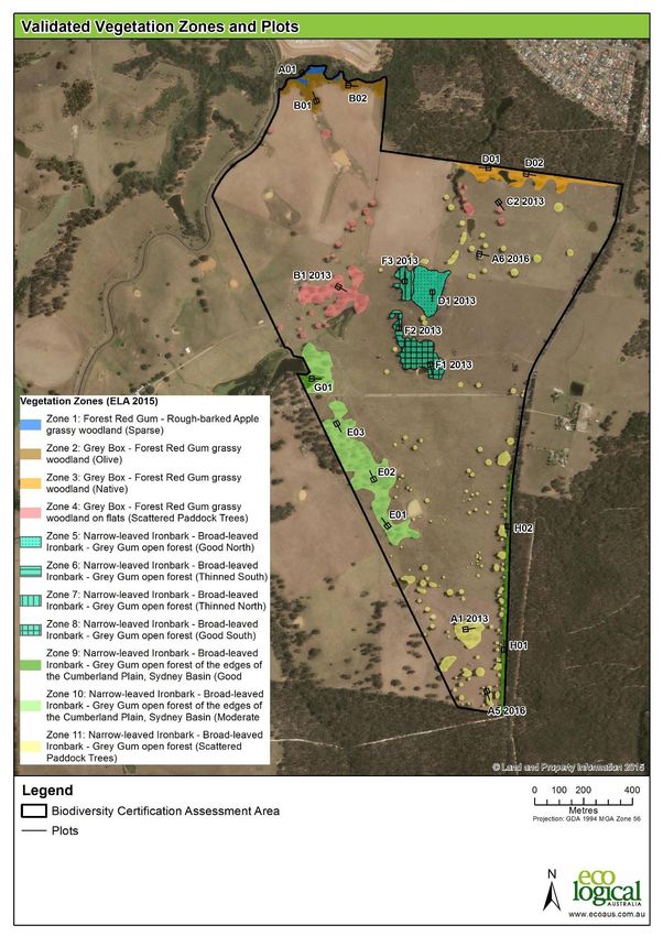
Mt Gilead Koala Carrying Capacity Assessment | Prepared for Lendlease Communities (Figtree Hill) Pty Limited

Figure 2: Mapped vegetation types and condition in approved Mt Gilead Stage 1

© ECO LOGICAL AUSTRALIA PTY LTD                                                                                                               4
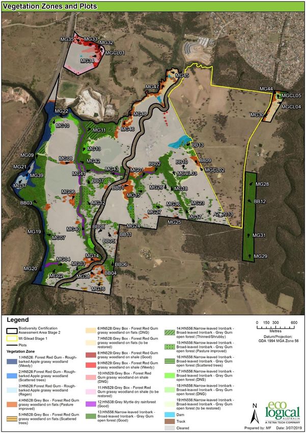
Mt Gilead Koala Carrying Capacity Assessment | Prepared for Lendlease Communities (Figtree Hill) Pty Limited

Figure 3: Mapped vegetation types and condition in proposed Mt Gilead Stage 2

© ECO LOGICAL AUSTRALIA PTY LTD                                                                                                               5
Mt Gilead Koala Carrying Capacity Assessment | Prepared for Lendlease Communities (Figtree Hill) Pty Limited

Figure 4: Impacted, retained and conserved Koala habitat Mt Gilead Stages 1 and 2

© ECO LOGICAL AUSTRALIA PTY LTD                                                                                                               6
Mt Gilead Koala Carrying Capacity Assessment | Prepared for Lendlease Communities (Figtree Hill) Pty Limited

Figure 5: Registered and proposed Biobank sites Mt Gilead Stages 1 and 2

© ECO LOGICAL AUSTRALIA PTY LTD                                                                                                               7
Mt Gilead Koala Carrying Capacity Assessment | Prepared for Lendlease Communities (Figtree Hill) Pty Limited

2. Methodology

Eco Logical Australia has mapped all of the vegetation, including scattered paddock trees (SPTs) in
cropped/grazed paddocks within the Mt Gilead property into five Plant Community Types (PCTs) being
Cumberland Plain Woodland (CPW) Shale Hills and Shale Plains sub-communities (SHW & SPW), Shale
Sandstone Transition Forest (SSTF), River-flat Eucalypt Forest (RFEF), and Grey Myrtle Dry Rainforest
(GMDR) (refer to Figures 2 and 3).

A total of 29.64 ha of native vegetation was mapped in Stage 1 and 265.81 ha in Stage 2 across the Mt
Gilead property. This vegetation was split into 19 vegetation condition zones and the area calculated by
GIS (Table 1 and Table 2) and (ELA 2018, 2019). These 19 vegetation condition zones were then further
classified into six current Koala habitat quality condition categories based on the condition of the
vegetation and presence/proportion of preferred Koala browse species present):-

1. Intact, good condition remnant woodland/forest -largely restricted to the Nepean River corridor and
   other patches of vegetation fenced out from grazing pressures (High quality Koala habitat)
2. Moderate-Good modified vegetation – vegetation where canopy has been thinned, the shrub layer
   removed and ground cover modified by grazing and/or pasture improvement – little eucalypt
   regeneration (Moderate to high quality Koala habitat)
3. Scattered Paddock Trees (SPT) – Remnant individual or small copses of senescing trees in cleared
   paddocks – very little or no regeneration due to on-going grazing and land management activities
   Moderate to high quality Koala habitat (Low to Moderate quality Koala habitat -depending on tree
   species in patch)
4. Derived Native Shrubland (DNS) – areas with shrub and ground layer but all trees removed (Not
   used by Koalas)
5. Derived Native Grassland (DNG) – areas of native ground cover with all shrub, mid-story and canopy
   removed (Not used by Koalas)
6. Cleared – exotic pasture/cropped areas (Not used by Koalas)

In October 2019 the Department of Planning, Industry & Environment (DPI&E) prepared a report on the
Campbelltown-Wollondilly Koala population as part of its submission on the Greater Macarthur Growth
Area (GMGA) exhibition. The report provides an estimate of Koala numbers and densities calculated
from spotlighting surveys at 0.052 Koalas/ha for ‘core habitat1’. DPI&E 2019 states that densities are
lower in non-core habitat. This is similar to the figure used in the Campbelltown Comprehensive Koala
Plan of Management (CKPoM) prepared by Biolink (2018) of 0.056 Koalas/ha based on an average
female home range of 36 ha (after Ward 2002) with 50% of suitable habitat occupied (i.e. 1 koala per 18
ha = 0.056 Koalas/ha) but lower than the density derived by Close and Ward (Ward pers. comm) of 0.1
Koalas/ha.

1 Core Koala habitat is defined by DPI&E as large patches (> 100ha) of ‘High Quality Koala habitat’ that contains known Koala
feed tree species and records of Koalas. High quality habitat includes CPW and SSTF.

© ECO LOGICAL AUSTRALIA PTY LTD                                                                                                                8
Mt Gilead Koala Carrying Capacity Assessment | Prepared for Lendlease Communities (Figtree Hill) Pty Limited

Based on the DPI&E density estimate, we have allocated indicative densities to each of the different
vegetation condition categories ranging from 0.00 Koalas/ha for cleared land, derived native grassland
or shrubland) to 0.05 Koalas/ha for intact high quality habitat in accordance with Table 3 and the images
of these condition categories in Plates 1-10.

These indicative densities have then been used to determine the Koala carrying capacity for the Mt
Gilead property at year 0 (2019), prior to any development or clearing of habitat, i.e. in its current state
and land management practices, including the on-going loss of SPTs at the rate of 2% per year (due to
senescence of existing trees as determined by ArborSafe 2017) and the on-going loss of Koalas crossing
Appin Rd (a conservative estimate of 3 road deaths/year has been used), by multiplying the area of koala
habitat in the various condition categories in Tables 1 and 2 by the relevant density in Tables 3 & 4,
resulting in Table 5.

Table 5 shows the predicted Koala numbers (area x density) in land proposed for development, open
space or protected conservation areas in 3 year increments from Year 0 to Year 25 (likely 2019-2044) .

The loss of Koalas in development areas follows the staged development (clearing of Koala habitat) over
25 years.

The increase in koala numbers follows the legal protection of proposed conservation areas as registered
Biobank sites (which includes the regeneration/restoration of 44.35 ha of pasture and derived grassland
to woodland) and selective landscape tree planting across 61.88 ha of open space areas. The Biobank
sites and open space areas will be actively managed for conservation, in perpetuity to improve the
condition of Koala habitat and hence predicted carrying capacity, compared to the existing situation
where there is no active conservation management or improvements in habitat quality. The
improvement in habitat quality is shown progressively in three year increments.

Studies of Koala use of four to seven and six to 15 year old farm land tree plantings on the Liverpool
Plains in NSW by Kavanagh & Stanton (2012) and Rhind et al. (2014) respectively, and 27-29 year old
mine site rehabilitation on North Stradbroke Island, Queensland by Woodward et al. (2008), have found
that koalas made ‘widespread’ use of trees planted in agricultural landscapes in all age classes studied
including use of four to seven year old plantings for feeding and shelter, which contrasts with earlier
studies by Smith (1992), that suggested koalas would not use plantings until they are older than 10 years
of age.

These studies all concluded that the strongest predictor of the use of planted habitat was proximity to
known koala records (i.e. area of occupied habitat) as is the case at Mt Gilead where supplementary
plantings of preferred browse species is adjacent to remnant patches of intact habitat to widen existing
corridors.

The predicted increase in koala density follows the general progression shown below for each 3 year
interval of active conservation management from Year 1 to Year 19, where there is an
predicted/assumed 0.01 Koala/ha increase in carrying capacity per three year interval from 0.0 Koala/ha
in zero aged regrowth to 0.05 Koala/ha in 20 year old plantings, and a final higher Koala density of 0.06
animals/ha after 25 years, maintained by the in perpetuity protection and active conservation
management of offset areas.

© ECO LOGICAL AUSTRALIA PTY LTD                                                                                                             9
Mt Gilead Koala Carrying Capacity Assessment | Prepared for Lendlease Communities (Figtree Hill) Pty Limited
This increase in carrying capacity is based on the restoration/regeneration of pasture and derived native
grasslands (as required by the Biobank site management plans), once offset areas are fenced and
grazing/cattle are removed at year 0, to the regeneration of eucalypts from soil stored seed and/or
supplementary plantings of preferred browse species to regenerated woodland after 16 years adjacent
to remnant patches of habitat, which will widen existing corridors.
Areas of existing modified and intact woodland will be improved by weed / feral animal control and
access control increasing to 0.06 Koala/ha after seven years for higher quality remnants and 13 years
for weedy remnants.
Retained trees in passive open space areas, such as adjacent to Woodhouse Creek, will be supplemented
by landscape plantings of preferred Koala browse species with the carrying capacity increasing from the
current 0.03 Koalas/ha, as for impacted scattered paddock trees, to 0.04/ha after 7 years with additional
plantings.
Similarly the off-site offset areas, whilst they are already in a similar condition to the remnant patches
of intact high quality habitat on Mt Gilead, they are not currently actively managed for conservation.
The carrying capacity of the off-site offsets associated with Stage 1 (21.27 ha of Koala habitat within
Noorumba Reserve and 21.13 ha at Appin West) have been calculated at 0.05 Koalas/ha from year 1 at
the commencement of active management, increasing to 0.06 Koalas/ha after 7 years of active
management.
An additional 70 ha of Koala habitat will be secured in an off-site offset for the proposed Stage 2
development. This has been factored into carrying capacity projections from Year 7.
Cleared Tree Planting Young Sapplings’ Young Regen
Paddock 4 years old Regeneration
0.0 Koala/ha 8-10 years old
0.0 Koala/ha 0.005 Koala/ha 4-7 years old
0.02 Koala/ha
0.01 Koala/ha
Advanced Restored Restored High quality
Regeneration Woodland Woodland habitat
> 11 years old > 16 years old >19 years old >25 years old
0.03 Koala/ha 0.04 Koala/ha 0.05 Koala/ha 0.06 Koala/ha
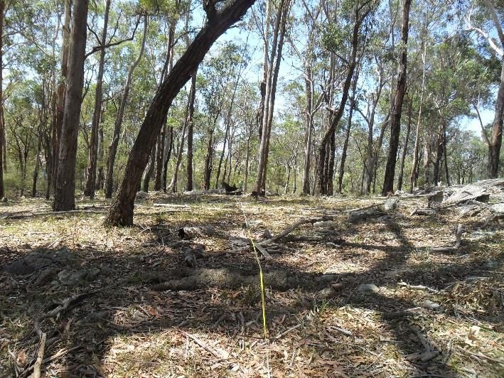
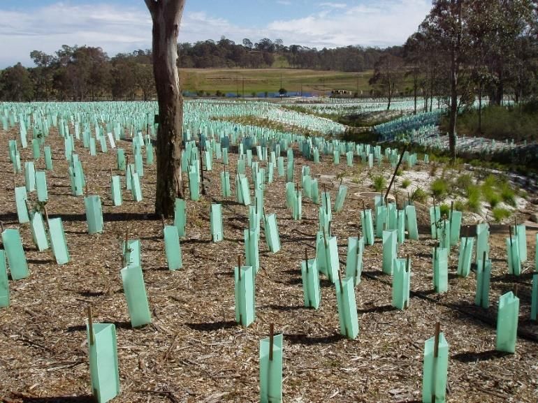
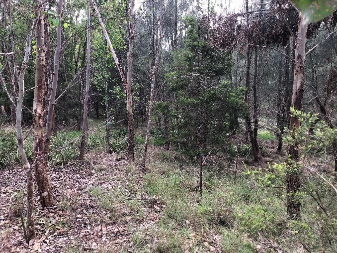
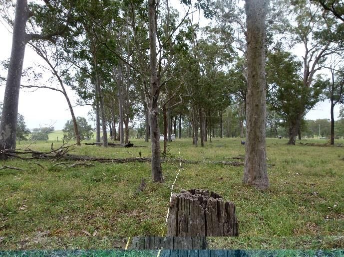
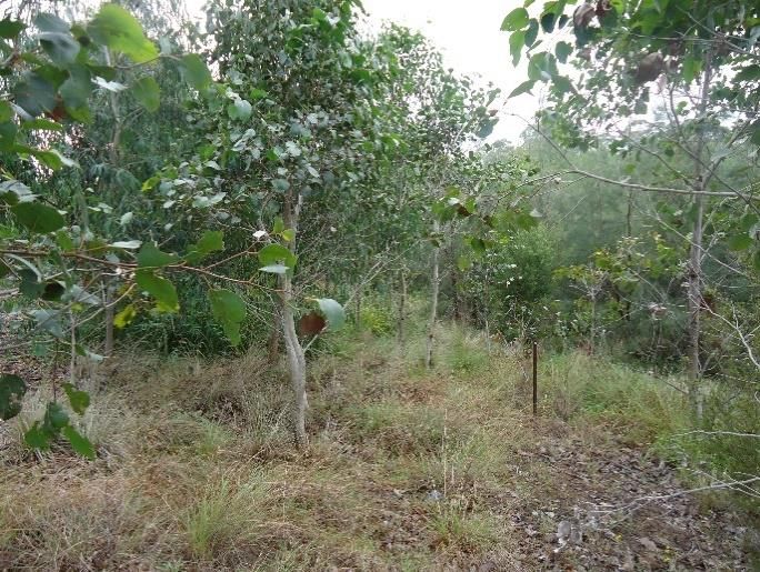
Plates 1-10 provides examples of vegetation in different condition states and the Koala density allocated
to these classes.
© ECO LOGICAL AUSTRALIA PTY LTD 10Mt Gilead Koala Carrying Capacity Assessment | Prepared for Lendlease Communities (Figtree Hill) Pty Limited
Table 1: Area and condition of Koala habitat – Mt Gilead Stage 1 (MDP Lands)
Veg Zone Vegetation Community Vegetation Current Koala Impacts Conservation Retained Rural Total
Condition Habitat Quality (Urban / (Biobank sites) Land/Open Space)
Roads)
1 Forest Red Gum - Rough-barked Apple grassy woodland on Low (weedy) Moderate-High 0.44 0 0.44
alluvial flats of the Cumberland Plain
2 Grey Box - Forest Red Gum grassy woodland on flats of the Moderate to good High 2.29 0 2.29
Cumberland Plain
3 Grey Box - Forest Red Gum grassy woodland on flats of the Sparse trees Moderate 0.15 2.34 0 2.49
Cumberland Plain (Grazed)
4 Grey Box - Forest Red Gum grassy woodland on flats of the Low (SPTs) Moderate 2.28 0 1.53 3.81
Cumberland Plain
5 Narrow-leaved Ironbark - Broad-leaved Ironbark - Grey Moderate to good High 0.19 1.81 0.04 2.04
Gum open forest of the edges of the Cumberland Plain
6 Narrow-leaved Ironbark - Broad-leaved Ironbark - Grey Moderate to good High 0.42 0.0 0.02 0.44
Gum open forest of the edges of the Cumberland Plain
7 Narrow-leaved Ironbark - Broad-leaved Ironbark - Grey Moderate (thinned) Moderate 0.76 0.0 0.02 0.78
Gum open forest of the edges of the Cumberland Plain
8 Narrow-leaved Ironbark - Broad-leaved Ironbark - Grey Moderate to good High 0.47 1.54 -0.02 1.99
Gum open forest of the edges of the Cumberland Plain
9 Narrow-leaved Ironbark - Broad-leaved Ironbark - Grey Moderate to good High 1.54 0.37 0.40 1.95
Gum open forest of the edges of the Cumberland Plain
10 Narrow-leaved Ironbark - Broad-leaved Ironbark - Grey Sparse trees Moderate 0.23 7.81 0.04 8.08
Gum open forest of the edges of the Cumberland Plain (grazed)
11 Narrow-leaved Ironbark - Broad-leaved Ironbark - Grey Low (SPTs) Moderate 4.75 0.0 0.58 5.33
Gum open forest of the edges of the Cumberland Plain
999 Dams Nil 0.20 -0.02
999 Cleared pasture Cleared Nil 154.76 5.7 18.79 179.25
165.55 22.5 20.84 208.89
© ECO LOGICAL AUSTRALIA PTY LTD 11Mt Gilead Koala Carrying Capacity Assessment | Prepared for Lendlease Communities (Figtree Hill) Pty Limited
Table 2: Area and condition of Koala habitat – Mt Gilead Stage 2 (Balance Lands)
Veg Vegetation Community Vegetation Condition Current Koala Direct Partial Conservation Open Total
Zone Habitat Quality Impacts Impacts (Biobank Space / Area
(Urban / (APZs / Sites) Rural
Roads) Detention Lands
Basins)
1 Forest Red Gum - Rough-barked Apple grassy woodland Weedy Moderate-High 2.73 0.53 18.94 3.67 25.87
on alluvial flats of the Cumberland Plain
2 Forest Red Gum - Rough-barked Apple grassy woodland Scattered trees Moderate-High 0.53 0.00 0.06 0.59
on alluvial flats of the Cumberland Plain
3 Forest Red Gum - Rough-barked Apple grassy woodland Quarry Regeneration None 2.17 0.00 0.22 2.39
on alluvial flats of the Cumberland Plain
4 Grey Box - Forest Red Gum grassy woodland on flats of Pasture Improved / Grazed High 8.41 1.16 16.81 2.08 28.46
the Cumberland Plain
5 Grey Box - Forest Red Gum grassy woodland on flats of Scattered trees Moderate 4.10 0.09 0 0.32 4.51
the Cumberland Plain
6 Grey Box - Forest Red Gum grassy woodland on flats of DNG None 0.00 0.09 2.65 0.37 3.11
the Cumberland Plain
7 Cleared - to be restore to CVPW (SPW) Cleared pasture (regeneration) None 0.00 0.00 12.32 0 12.32
8 Grey Box - Forest Red Gum grassy woodland on shale of Good High 0.06 0.00 2.39 2.45
the southern Cumberland Plain
9 Grey Box - Forest Red Gum grassy woodland on shale of Weedy High 0.10 0.00 2.09 0.38 2.57
the southern Cumberland Plain
10 Grey Box - Forest Red Gum grassy woodland on shale of DNG None 1.58 0.00 2.13 3.71
the southern Cumberland Plain
11 Cleared - to be restore to CPW SHW Cleared pasture (regeneration) None 0.00 0.00 5.45 5.45
12 Grey Myrtle dry rainforest Good Moderate-High 0.27 0.28 6.4 0.21 7.16
13 Narrow-leaved Ironbark - Broad-leaved Ironbark - Grey Good High 2.87 4.13 94.22 3.27 104.49
Gum open forest of the edges of the Cumberland Plain
© ECO LOGICAL AUSTRALIA PTY LTD 12Mt Gilead Koala Carrying Capacity Assessment | Prepared for Lendlease Communities (Figtree Hill) Pty Limited
Veg Vegetation Community Vegetation Condition Current Koala Direct Partial Conservation Open Total
Zone Habitat Quality Impacts Impacts (Biobank Space / Area
(Urban / (APZs / Sites) Rural
Roads) Detention Lands
Basins)
14 Narrow-leaved Ironbark - Broad-leaved Ironbark - Grey Thinned/Shrubby High 0.00 0.00 6.61 6.61
Gum open forest of the edges of the Cumberland Plain
15 Narrow-leaved Ironbark - Broad-leaved Ironbark - Grey Pasture Improved / Grazed Low - Moderate 30.61 10.43 13.63 5.42 60.09
Gum open forest of the edges of the Cumberland Plain,
Sydney Basin Bioregion
16 Narrow-leaved Ironbark - Broad-leaved Ironbark - Grey Scattered trees Low - Moderate 5.58 0.34 0.37 0.61 6.9
Gum open forest of the edges of the Cumberland Plain
17 Narrow-leaved Ironbark - Broad-leaved Ironbark - Grey DNS None 0.17 0.66 5.07 0.33 6.23
Gum open forest of the edges of the Cumberland Plain,
Sydney Basin Bioregion
18 Narrow-leaved Ironbark - Broad-leaved Ironbark - Grey DNG None 0.00 0.00 0.67 0.67
Gum open forest of the edges of the Cumberland Plain
19 Cleared - to be restore to SSTF Cleared pasture (regeneration) None 0.00 0.00 10.36 0 10.36
555 Dams / Tracks Dams / Tracks No 0.34 0.09 1.41 4.24 6.08
999 Cleared pasture (regeneration) Cleared pasture (regeneration) No 243.31 11.54 0.01 117.69 372.55
Total 302.83 29.34 201.81 138.59 672.57
© ECO LOGICAL AUSTRALIA PTY LTD 13Mt Gilead Koala Carrying Capacity Assessment | Prepared for Lendlease Communities (Figtree Hill) Pty Limited
Table 3: Allocation of Koala densities to different condition vegetation in impact areas
Vegetation Condition Current Koala habitat quality Estimated Koala density (Koalas/ha
Remnant High Quality CPW/SSTF High quality Koala habitat 0.05
Modified CPW/SSTF patches (Weedy, grazed, under-scrubbed) Moderate to high quality Koala habitat 0.04
Scattered Paddock Trees (SPT) with high proportion of browse species (CPW remnants) Moderate to high quality Koala habitat 0.04
Scattered Paddock Trees (SPT) with high proportion of browse species (Thinned SSTF remnants) Low to moderate to high quality Koala habitat 0.03
Public Open Space/Asset Protection Zones (retained canopy and landscape plantings) Low to moderate to high quality Koala habitat 0.03
Derived Native Grassland (DNG) and Shrubland (DNS) None 0.0
Exotic Pasture (no trees) None 0.0
Table 4: Allocation of Koala densities to different condition vegetation in offset and open space areas and changes in density over 25 years resulting from restoration and management
Koala densities
Vegetation Condition Year 0 Year 1 Year 4 Year 7 Year 10 Year 13 Year 16 Year 19 Year 22 Year 25
Remnant ‘High Quality’ CPW/SSTF 0.050 0.050 0.050 0.060 0.060 0.060 0.060 0.060 0.060 0.060
Modified CPW/SSTF patches (Weedy, grazed, under scrubbed) 0.040 0.040 0.040 0.050 0.050 0.060 0.060 0.060 0.060 0.060
Public Open Space & Drainage (APZs/Landscape plantings) Stage 1 0.000 0.000 0.005 0.010 0.020 0.030 0.030 0.030 0.030 0.030
Public Open Space & Drainage (APZs/Landscape plantings) Stage 2 0.030 0.030 0.030 0.040 0.040 0.040 0.040 0.040 0.040 0.040
Retained Land – no management (Modified CPW/SSTF patches) 0.040 0.040 0.040 0.040 0.040 0.040 0.040 0.040 0.040 0.040
Advanced Regeneration (>11 years old) / Scattered Paddock Trees (SPT) 0.030 0.030 0.040 0.050 0.050 0.060 0.060 0.060 0.060 0.060
Regeneration (8-10 years old) 0.020 0.020 0.030 0.040 0.050 0.050 0.060 0.060 0.060 0.060
Young Regeneration (4-7 years old) – DNS areas 0.010 0.010 0.020 0.030 0.040 0.050 0.050 0.060 0.060 0.060
Restoration/Regeneration (< 4 years old) – DNG areas 0.005 0.005 0.010 0.020 0.030 0.040 0.050 0.050 0.060 0.060
Exotic Pasture (no trees) 0.000 0.000 0.005 0.010 0.020 0.030 0.040 0.050 0.050 0.060
© ECO LOGICAL AUSTRALIA PTY LTD 14Mt Gilead Koala Carrying Capacity Assessment | Prepared for Lendlease Communities (Figtree Hill) Pty Limited
Plates 1-10: Selection of images of current vegetation condition across the Mt Gilead property and habitat restoration
examples at Harrington Park, near Camden
Pasture and derived grassland 0.0 Koalas/ha Indicative tree planting at Harrington Park in pasture adjacent
0.000 Koalas/ha (0-1 years old)
Young CPW regeneration at Harrington Park 4-years old 0.005 Koalas/ha 11 years old regeneration at Harington park
0.02 Koalas/ha
© ECO LOGICAL AUSTRALIA PTY LTD 15Mt Gilead Koala Carrying Capacity Assessment | Prepared for Lendlease Communities (Figtree Hill) Pty Limited Mature to senescent Scattered Paddock Trees and landscape planting in open space areas - 0.03 Koala/ha) Stands of thinned / under scrubbed Shale Sandstone Transition Forest – 0.03 -0.04 Koalas/ha Left - Intact SSTF to be protected in Nepean River corridor (Nepean Biobank Site) – 0.05 Koalas/ha Right - Intact SSTF east of Appin Road in strategic Koala corridor to be protected (Browns Bush Biobank Site) – 0.05 Koalas/ha © ECO LOGICAL AUSTRALIA PTY LTD 16
Mt Gilead Koala Carrying Capacity Assessment | Prepared for Lendlease Communities (Figtree Hill) Pty Limited

3. Results

Using the areas in Tables 1, 2 and densities in Table 3, it has been estimated that the Mt Gilead property
(approved Stage 1 and proposed Stage 2) has a current carrying capacity of 12.78 Koalas for the existing
275.5 ha of potential Koala habitat in varying condition states (as shown in Table 5 and Figure 6).

In the absence of any development, it is estimated this carrying capacity would reduce to a potential
10.97 Koalas over 25 years due to the on-going incremental loss of senescent browse trees in the
operational parts of the property (Figure 6). There would also be the on-going loss of 3-4 Koalas per year
from existing roadkill rates along Appin Road as shown in Figure 7 which whilst not affecting carrying
capacity, is affecting the number of koalas in the area and the occupation of this habitat.

The loss of potential Koala habitat in the approved Stage 1 development (10.79 ha) and proposed Stage
2 development (55.26 ha direct loss and 16.96 ha for partial impacts in APZs) comprise 23% of this total
or habitat for 3.00 Koalas, that would be lost gradually over 25 years as shown in Figure 6.

Under the development proposal, where by 222.69 ha of on-site Koala habitat would be permanently
protected and actively managed for conservation, and a further 61.96 ha of open space would be
enhanced with landscape tree plantings, the carrying capacity of the offset areas would increase by 6.39
koalas over 25 years (9.78 to 16.17 Koalas (as the result of revegetation of 44.355 ha of cleared land to
higher quality koala habitat over 25 years and improving the condition of 178.34 ha of existing habitat)
(Table 4, Figures 6 and 8).

This increase more than doubles the loss of 3.0 koalas over the same 25 years. When improvements to
the carrying capacity of an additional 112 ha of off-site koala habitat are added, this increases the
carrying capacity off-site by a further 6.76 koalas to 22.93 (Figures 8 and 9).

Figure 9 shows the relative contribution that the loss of habitat for 3 koalas over 25 years compares to
the loss in habitat from current rural land management practices and the on-going loss of animals
through roadkill along Appin Road.

The development proposal and commitments made will lead to a long term improvement in the quality
and security of habitat and reduce a significant threat (the existing level of road mortality on Appin Road)
to the sustainability of the Koala population in the Mt Gilead area.

A Koala Management Plan will be prepared and implemented, similar to the Stage 1 Koala Management
Plan (ELA 2019b) that will include measures to mitigate the impacts of local traffic, dogs and swimming
pool drownings and guide the management of open space areas. Local Government Act by-laws will put
controls in place for dogs in open space areas including, where appropriate, the provision of dedicated
dogs off lead areas.

Further, an adaptive Koala monitoring and research program will be prepared and implemented to
assess the use of offset areas by Koala and assess any indirect impacts resulting from the adjacent urban
development. The findings of this research program will be used to develop further mitigation measures,
as necessary.

© ECO LOGICAL AUSTRALIA PTY LTD                                                                                                            17
Mt Gilead Koala Carrying Capacity Assessment | Prepared for Lendlease Communities (Figtree Hill) Pty Limited

Table 5: Predicted Koala carrying capacity before and after development/conservation management Years 1-25

 Year                                                                                                      Yr 0      Yr 1       Yr 4      Yr 7       Yr 10     Yr 13      Yr 16      Yr 19     Yr 22      Yr 25

 No. Koalas in Urban Area - MDP lands                                                0.457                 0.46      0.24       -0.00     0.00       0.00      0.00       0.00       0.00      0.00       0.00

 No. Koalas in Urban Area - Balance lands                                            2.545                 2.55      2.55       2.55      2.44       2.03      1.38       1.15       1.06      0.39       0.00

                                                          Koala's in Urban Area      3.003                 3.00      2.78       2.54      2.44       2.03      1.38       1.15       1.06      0.39       0.00

 No. Koalas in Open Space/APZs - MDP Lands                                           0.000                 0.00      0.00       0.02      0.34       0.68      1.02       1.02       1.02      1.02       1.02

 No. Koalas in Open Space/APZs - Balance Lands                                       0.842                 0.84      0.84       0.84      1.12       1.12      1.12       1.12       1.12      1.12       1.12

 No. Koalas in Retained Land (incl. Homestead)                                       0.666                 0.67      0.67       0.67      0.67       0.67      0.67       0.67       0.67      0.67       0.67

                                                          Koala's in Open Space      1.509                 1.51      1.51       1.53      2.13       2.47      2.81       2.81       2.81      2.81       2.81

 Carrying Capacity On-site Offsets - x 3                                             0.724                 0.72      0.72       0.75      0.95       1.00      1.17       1.22       1.28      1.28       1.34

 Carrying Capacity On-site Offsets - Balance x 5                                     7.542                 7.54      7.62       7.99      9.85       10.24     10.88      11.36      11.69     11.74      12.02

                                                        Koala's in on-site offsets   8.266                 8.27      8.35       8.74      10.80      11.24     12.05      12.58      12.97     13.02      13.36

 Carrying Capacity Off-site Offsets - MDP (Noorumba)                                 1.064                           1.06       1.06      1.28       1.28      1.28       1.28       1.28      1.28       1.28

 Carrying Capacity Off-site Offsets - MDP (West Appin)                               1.057                           1.06       1.06      1.27       1.27      1.27       1.27       1.27      1.27       1.27

 Carrying Capacity Off-site Offsets - Balance (70 ha)                                3.514                                                3.51       3.51      4.22       4.22       4.22      4.22       4.22

                                                        Koalas in off-site offsets   5.634                 0.00      2.12       2.12      6.06       6.06      6.76       6.76       6.76      6.76       6.76

 Total Carrying Capacity - MDP Lands on-site                                         1.273                 1.18      0.96       0.77      1.29       1.68      2.18       2.24       2.30      2.30       2.35

 Total Carrying Capacity - Balance Lands on-site                                     10.719                11.60     11.68      12.04     14.08      14.06     14.05      14.29      14.54     13.92      13.81

     Development Scenario - Total Carrying Capacity (Excl. Off-site offsets)                               12.78     12.64      12.81     15.36      15.74     16.24      16.53      16.84     16.22      16.17

 Development Scenario - Total Carrying Capacity (On-site & Off-site offsets)                               12.78     14.76      14.93     21.42      21.80     23.00      23.29      23.60     22.98      22.93

 No Development Scenario                                                             2% Loss of trees in   11.99     11.94      11.79     11.65      11.52     11.40      11.28      11.17     11.07      10.97
                                                                                     urban & open space
                                                                                     areas

© ECO LOGICAL AUSTRALIA PTY LTD                                                                                                                                                                                  18
Mt Gilead Koala Carrying Capacity Assessment | Prepared for Lendlease Communities (Figtree Hill) Pty Limited
Mt Gilead - On-site Koala Carrying Capacity
25.00
23.00
21.00
19.00
16.17
17.00
15.00
12.78
13.00
11.00
11.99
10.97
9.00
Yr 0 Yr 1 Yr 4 Yr 7 Yr 10 Yr 13 Yr 16 Yr 19 Yr 22 Yr 25
No Development Scenario Development Scenario - Total Carrying Capacity (Excl. Off-site offsets)
Figure 6: Koala carrying capacity – current land management and loss of trees
© ECO LOGICAL AUSTRALIA PTY LTD 19Mt Gilead Koala Carrying Capacity Assessment | Prepared for Lendlease Communities (Figtree Hill) Pty Limited
Mt Gilead - Impact Assessment (CUM)
10.00
0.00
Yr 0 Yr 1 Yr 4 Yr 7 Yr 10 Yr 13 Yr 16 Yr 19 Yr 22 Yr 25
-10.00
-20.00
-30.00
-40.00
-50.00
-60.00
-70.00
-80.00
Cumulative loss from road kill (3 Koalas/year)
Loss from Urban Development
Cumulative loss of trees (current land management)
Cumulative Change Carrying Capacity (Development)
Figure 7: Relative contribution of roadkill, tree loss and development to Koala numbers over 25 years
© ECO LOGICAL AUSTRALIA PTY LTD 20Mt Gilead Koala Carrying Capacity Assessment | Prepared for Lendlease Communities (Figtree Hill) Pty Limited
Mt Gilead - Increase in Koala carrying capacity by management of on & off-site offsets over 25
years
14.00
12.00
10.00
8.00
6.00
4.00
2.00
0.00
Yr 0 Yr 1 Yr 4 Yr 7 Yr 10 Yr 13 Yr 16 Yr 19 Yr 22 Yr 25
On-site offsets (223 ha) Off-site offsets (112 ha) Total Offsets
Figure 8: Increase in Koala carrying capacity with management of on-site and off-site offset areas
© ECO LOGICAL AUSTRALIA PTY LTD 21Mt Gilead Koala Carrying Capacity Assessment | Prepared for Lendlease Communities (Figtree Hill) Pty Limited
Mt Gilead - Total Koala Carrying Capacity
25.00
22.93
23.00
21.00
19.00
17.00
15.00
12.78
13.00
10.97
11.00 11.99
9.00
Yr 0 Yr 1 Yr 4 Yr 7 Yr 10 Yr 13 Yr 16 Yr 19 Yr 22 Yr 25
No Development Scenario Development Scenario - Total Carrying Capacity (On-site & Off-site offsets)
Figure 9: Change in total Koala carrying capacity following development and land management
© ECO LOGICAL AUSTRALIA PTY LTD 22Mt Gilead Koala Carrying Capacity Assessment |
4. Discussion
Predicted increases to the extent of Koala habitat and the resulting carrying capacity on the Mt Gilead
property are achieved by a commitment to commence active conservation management and restoration
of proposed offset areas to widen and buffer existing corridors from urban areas from year 1 including:-
• restoration of 5.7 ha and 28.13 ha of cleared land in registered and proposed biobank sites in
Stage 1 and Stage 2 respectively to higher quality remnant vegetation,
• the return of tree canopy to 10.52 ha of derived grassland/shrubland in Stage 2 offset areas;
and
• the preferential planting of Koala browse species (Forest Red Gum, Grey Box, Grey Gum and
White Stringybark) and other species indicative of Cumberland Plain Woodland and Shale
Sandstone Transition Forest in 33.8 and 28.08 ha of open space in Stages 1 and 2 respectively
Koala habitat will be progressively impacted over 25 years and replaced by restored habitat which will
be significantly advanced regrowth prior to all impacts occurring. Of the 55.26 ha of habitat to be lost
and 16.96 ha to be modified in Stage 2, approximately 5 ha will be lost in Stage 2.1 (Year 7), 12 ha in
Stage 2.2 (Year10), 20 ha in Stage 2.3 (Year 13), 5 ha in Stage 2.4 Year 16), 3 ha in Stage 2.5 (Year 19), 19
ha in Stage 2.6 (Year 22) and 11 ha in Stage 7 (Year 25), i.e. around 40 % of the impacts will not occur
until after year 22.
Roads are considered one of the major factors leading to decline in koala populations (Rhodes et al
2014). Crowther (2018) in his report to the former OEH regarding the management of koala road kill on
Appin Road, states that where there is heavy traffic and rising human population growth, such as in the
Campbelltown LGA, mitigation measures for road effects are essential for koala population persistence.
Professor Crowther considers that exclusion fencing along Appin Road has the capability to reduce
mortality in the local population, increase population persistence and if combined with under or
overpasses, facilitate movement and gene flow. Lee et al. (2010) report of low genetic diversity in the
Campbelltown Koala population indicating a recent population bottleneck. They highlight the need to
identify possible solutions to allow gene flow across population barriers.
Whilst not affecting the carrying capacity of protected and/or managed habitat on Mt Gilead, the
proposed wildlife exclusion fencing and fauna underpass along Appin Rd (subject to RMS approval) will
contribute to reducing the current rate of Koala roadkill that DPI&E and others regard as having a
significant impact on the local population. The exclusion fencing and underpass will provide increased
security to Koalas making east to west and west to east crossings of Appin Road to other areas of core
habitat and improve gene flow between the broader Campbelltown/Wedderburn/Heathcote koala
population and those animals to the west of Appin Road and south to Appin and Wilton.
© ECO LOGICAL AUSTRALIA PTY LTD 23Mt Gilead Koala Carrying Capacity Assessment | 5. References ArborSafe 2017. Mt Gilead Tree Assessment Report – November 2017. Biolink 2016. Comprehensive Koala Plan on Management (Draft). Prepared by Biolink for Campbelltown City Council, 2016. Biolink 2018a. South Campbelltown Koala Habitat Connectivity Study. Final report to Campbelltown City Council, updated April 2018. Biolink 2018b. Comprehensive Koala Plan on Management (Revised Draft). Prepared by Biolink for Campbelltown City Council, September 2018. Crowther, M. 2018. Review of Office of Environment and Heritage (OEH) Project “Temporary fencing on Appin Road – Analysis of costs and benefits for Koalas”. Letter to Senior Team Leader Ecosystems and Threatened Species, Greater Sydney Branch, OEH, dated 28 June 2018. Department of Planning, Industry and Environment (DPIE) 2019. Conserving Koalas in the Wollondilly and Campbelltown Local Government Areas. Eco Logical Australia 2018. Mt Gilead – Biodiversity Certification Assessment Report and Biocertification Strategy, Report prepared for Mt Gilead Pty Ltd and MR & Mrs Dzwonnik, dated 2 July 2018, Final Report to Minister, July 2018. Eco Logical Australia 2019. Mt Gilead Stage 2– Biodiversity Certification Assessment Report and Biocertification Strategy, Report prepared for Lendlease Communities (Figtree Hill) Pty Limited, dated 18 July 2019. Eco Logical Australia 2019b Mount Gilead Residential Development - Koala Management Plan. Report prepared for Lendlease Communities (Mt Gilead) Pty Limited, dated June 2019. Kavanagh, R. and Stanton, M.A. 2012. Koalas use young Eucalyptus plantations in an agricultural landscape on the Liverpool Plains, New South Wales. Ecolog. Manage. & Restoration 13: 297-305. Lee, K.E., Seddon, J.M., Corley, W., Ellis, W.A.H., Johnston, S.D., de Villiers, D.L., Preece, H.J., and Carrick, F.N. 2010. Genetic variation and structuring in the threatened koala populations of southeast Queensland. Conservation Genetics 11, 2091-2103. Lunney, D. Close, R., Bryant, J.V., Crowther, M.S., Shannon, I., Madden, K. and Ward, S. 2010. The koalas of Campbelltown, south-western Sydney: does their natural history foretell of an unnatural future? Pp339 - 370 in The Natural History of Sydney, edited by Daniel Lunney, Pat Hutchings and Dieter Hochuli. Royal Zoological Society of NSW, Mosman, NSW, Australia. Rhodes, J.R., Lunney, D., Callaghan, J. and McAlpine, C.A. 2014. A few large roads or many smaller ones? How to accommodate growth in vehicle numbers to minimise impacts on wildlife. Plos One 9, e91093.doi: 10.1371/Journal.pone.0091093. © ECO LOGICAL AUSTRALIA PTY LTD 24
Mt Gilead Koala Carrying Capacity Assessment |

Rhind, S.G., Ellis, M.V., Smith, M. and Lunney, D. 2014. Do Kolas Phascolarctos cinereus use trees planted
on farms? A case study form north-west New South Wales, Australia. Pacific Conservation Biology 20(3):
302-312.

RMS 2018. Appin Road Upgrade, Mt Gilead to Ambervale: Review of Environmental Factors, Roads and
Maritime Services, November 2018.

Smith, M. 1992. Koalas and land use in the Gunnedah Shire: A report on the Bearcare project. NSW
National Parks and Wildlife Service, Hurstville, NSW.

Ward, S. J. 2002 Koalas and the community: a study of low density populations in Southern Sydney.
Unpublished PhD thesis, University of Western Sydney, Campbelltown, NSW.

Woodwood, W., Ellis, W.A., Carrick, F.N., Tanizaki, M., Bowen, D. and Smith ,P. 2008. Koalas on North
Stradbroke Island: diet, tree use and reconstructed landscapes. Wildl. Res 35: 606-611.

Appendix A : Arborsafe Tree Assessment Report

Provided as separate document.

Appendix B : Dr Steven Ward’s review of draft carrying capacity report

Provided as separate document.

© ECO LOGICAL AUSTRALIA PTY LTD                                                                                     25
Mt Gilead Koala Carrying Capacity Assessment |

© ECO LOGICAL AUSTRALIA PTY LTD                                              26
You can also read