Conversion of agricultural soils in Austria-a case study for a community in Upper Austria - Sciendo
←
→
Page content transcription
If your browser does not render page correctly, please read the page content below
Die Bodenkultur: Journal of Land Management, Food and Environment
Volume 71, Issue 2, 69–76, 2020. 10.2478/boku-2020-0007
ISSN: 0006-5471 online, https://content.sciendo.com/view/journals/boku/boku-overview.xml

Research Article

    Conversion of agricultural soils in Austria—a case study for a
                   community in Upper Austria
                   Bodenversiegelung in Österreich – eine Fallstudie für eine
                               oberösterreichische Gemeinde
              Günther Aust, Franz Heinrich, Daniel Horvath, André Musil, Cecilie Foldal, Robert Jandl*

Austrian Forest Research Center, Institute of Forest Ecology, Seckendorff Gudent Weg 8, 1131 Vienna, Austria

* Corresponding author: robert.jandl@bfw.gv.at

Received: 29 February 2020, received in revised form: 22 April 2020, accepted: 22 April 2020

                                                                 Summary
We have analyzed the loss of agricultural land in a case study of the community Eggelsberg in the Innviertel in Upper Austria.
The trigger for the project was the attribution of Austria as Europe’s leader in soil sealing. We compared the results of the Austrian
agricultural soil survey of the 1970s with the actual land use and quantified the land use change. Within half a century, 15% of
the agricultural area was converted to settlement area or to other forms of infrastructure. According to the original soil assessment,
96 ha of high-quality cropland, 1,220 ha of medium-quality cropland, 121 ha of low-quality cropland, and 409 ha of grassland were
converted. The forest cover remained stable. The highest share of soil sealing was owed to the expansion of the settlement area and
the construction of a successful enterprise. Minor contributions were expansions of farm buildings. The loss of agricultural land was
reasonable and reflected the needs of the local population. A special protection status because of the future relevance of the agricul-
tural land was not communicated to land managers and is not reflected in the market prices of agricultural products. The relevance
of the agricultural land beyond the regional level is not fully recognized.
Keywords: soil protection, soil loss, food security, soil value, structural change, cropland

                                                           Zusammenfassung
Wir haben den Verlust an landwirtschaftlicher Nutzfläche am Beispiel der Gemeinde Eggelsberg im Innviertel in Oberösterreich unter-
sucht. Anlass der Untersuchung war die Bezeichnung von Österreich als Europameister der Bodenversiegelung. Die Landnutzung der
fünf Jahrzehnte zurückliegenden landwirtschaftlichen Bodenkartierung wurde mit GIS-Werkzeugen mit der aktuellen Bodenverwen-
dung verglichen. Die Veränderung der Landnutzung wurde quantifiziert. Wir haben festgestellt, dass in einem halben Jahrhundert
insgesamt 15 Prozent der landwirtschaftlichen Nutzfläche verbaut worden sind. Davon waren 96 Hektar hochwertiges, 1220 Hektar
mittelwertiges und 121 Hektar geringwertiges Ackerland und 409 Hektar Grünland betroffen. Die Umwandlung zu Wald spielte im
Untersuchungsgebiet keine Rolle. Der größte Teil der Nutzungsumwandlung erfolgte aufgrund der Vergrößerung des Siedlungsgebietes
und zur Ansiedlung eines Industriebetriebes. Außerdem wurden Zubauten an Höfen vorgenommen. Insgesamt ist die Veränderung der
Bodennutzung gut begründet und entspricht den Bedürfnissen der regionalen Bevölkerung. Die Erhaltung der landwirtschaftlichen
Nutzfläche der Region wurde an die Landbewirtschafter nicht explizit diskutiert und ist in den Preisen der landwirtschaftlichen Pro-
dukte nicht reflektiert. Allerdings hat sich die Bewertung der Qualität des Landes durch den kontinuierlich stattfindenden Klimawandel
geändert. Der Bedeutung des Bodens für eine künftige Versorgung mit landwirtschaftlichen Produkten wurde nur teilweise Rechnung
getragen. Die überregionale Bedeutung des Bodens als Produktionsfläche wurde nicht ausreichend kommuniziert.
Schlagworte: Bodenschutz, Bodenverlust, Ernährungssicherheit, Bodenwert, Strukturwandel, Ackerland

  Open Access. © 2020 Günther Aust, Franz Heinrich, Daniel Horvath, André Musil, Cecilie Foldal, Robert Jandl, published by Sciendo.
This work is licensed under the Creative Commons Attribution-NonCommercial-NoDerivatives 3.0 License.
https://doi.org/10.2478/boku-2020-0007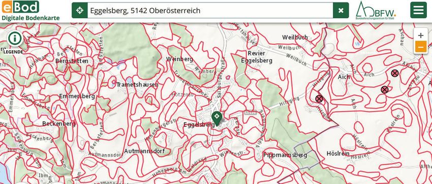
70 Günther Aust et al.
1. Introduction 2. Material and methods
The annual soil loss in Austria is high. The Environment 2.1. An agricultural community in Upper Austria
Agency Austria reports, since several years, that the daily
soil conversion amounts to more than 10 ha, which is As a case study, we selected the community Eggelsberg
by a factor of 5 above the sustainable soil conversion rate that is located in the Innviertel in Upper Austria. The vil-
(https://www.umweltbundesamt.at/umweltsituation/rau- lage is located at 531 m a.s.l. and comprises the cadastral
mordnung/rp_flaecheninanspruchnahme/). The major- communities Eggelsberg, Gundertshausen, Haimhausen,
ity is potential cropland and grassland that is converted Haselreith, and Ibm. The total area is 24.2 km². About
into area for buildings and streets, thereby being perma- one-fifth of the area is forest, and more than two-thirds are
nently lost as productive land. The soil loss is often memo- used as agricultural land. The agricultural soils are mostly
rably compared with multitudes of areas of soccer pitches Cambisols (Braunerde) derived from quaternary gravel
(approximately 0.5 ha) in order to emphasize the extent and moraines. The village is intersected by a few main
of the challenge of soil protection. The topic raised politi- roads that connect local centers.
cal attention, and efforts toward soil conservation were
prominently placed in the Government Program 2017,
2.2. Assessment of the land use change for 50 years
the National Climate and Energy Program (#mission2030,
BMNT 2018), and the Bio-economy Strategy (BMNT The soils of the area have been mapped between 1963 and
2019) in order to facilitate a growing supply of biomass 1976 within the program of the Austrian Agricultural Soil
and to sustainably ensure the provision of soil ecologi- Survey (BVA, 1976). A field crew assessed the soil quality
cal functions. The relevance of productive and functional for agricultural use, among others, by means of soil type,
soils was emphasized in the Environment Control Report soil depth, soil texture and gravel content, and the soil’s
(UBA, 2019). water-holding capacity. In addition, soil material from ref-
On top of soil loss as a consequence of structural change erence profiles was collected and chemically analyzed for
of the society, climate change is posing an additional chal- pH, organic carbon, and additional chemical soil parame-
lenge. At present, sites in the North-East of Austria have ters. As the surveyor has also assessed the value of the map-
the highest production potential. Scenarios for the future ping units regarding arable land and grassland, it is possible
productivity of grassland and cropland suggest that the to identify “high-value cropland”, “medium-value crop-
productivity of grassland in mountain regions may increase land”, “low-value cropland”, and “grassland” in the soil
and benefit from climate change, whereas cropland in low map. The spatial extent of soil forms was transferred to the
elevation will become less productive. Within a few dec- Austrian map at a scale of 1:25,000. The Austrian agricul-
ades, the productivity potential of agricultural sites in cen- tural soil maps were digitized between 1995 and 2000 and
tral Austria (e.g., Innviertel in Upper Austria) will exceed were published as e-bod (https://www.data.gv.at/anwend-
the productivity of other regions, mostly as a consequence ungen/digitale-bodenkarte-ebod/). The digitized soil map
of higher temperatures and a sufficient soil water supply was saved as a layer in the geographical information system
(Haslmayr et al., 2018). In order to provide for future food QGIS (http://www.qgis.org) and used as reference for the
security, experts suggest to define soil conservation sites (in previous land use.
German: Boden-Vorbehaltsflächen) that should enjoy a The current land use was derived from the most recent
certain protection status in order to preferentially main- orthophoto that was available as a basemap (https://www.
tain them for crop production (Baumgarten, 2019). basemap.at/). The last update of the used data was made
We analyzed the extent of soil conversion for a commu- on December 5, 2019. The actual extent of cropland was
nity in Upper Austria where agriculture plays an impor- digitized on the orthophoto and was saved as individual
tant role. We used the data from the Austrian Agricultural layer in QGIS.
Soil Survey (https://bodenkarte.at/) in order to quantify The forest cover was obtained from the results of an
the soil conversion during approximately 40 years. ongoing remote sensing project conducted at the Aus-
trian Forest Research Center (https://bfw.ac.at/rz/bfwcms.
web?dok=7222; Schadauer et al., 2019). The shapefile was
available from a public data hub (BMLFUW, 2017).
Die Bodenkultur: Journal of Land Management, Food and Environment 71 (2) 2020
Conversion of agricultural soils in Austria—a case study for a community in Upper Austria 71
The map of soils with a high yield potential was created took place irrespective of its value as an agricultural pro-
within a project on scenarios of food security for Aus- duction site and was equally distributed among the site-
tria and was obtained from the INSPIRE data reposi- quality classes.
tory (Haslmayr, 2018, Inspire 2020). The yield-potential Figure 3 shows the evaluation of land of the community
map was overlaid on the basemap of Austria (Grundkarte; Eggelsberg according to the recent data that are based on
http://www.basemap.at). the evaluations of the administration (Haslmayr, 2018).
The e-bod soil map and the digitized land-use map derived The evaluation of soil half a century after the soil survey
from the orthophoto were intersected. Tracts of land that shows that 36% of the area is evaluated as valuable crop-
have been previously classified as cropland but were not land and 11% as valuable grassland. This land is recom-
cropland on the orthophoto were identified. A visual mended to be spared from soil sealing in order to secure
inspection of the orthophoto allowed the distinction of the nonrenewable resource soil and to ensure food security
“new buildings,” “new roads,” and “other infrastructure.” in Austria (Table 2). Almost half of the agricultural land of
In addition, the converted land was classified into “village the community Eggelsberg is considered to be highly valu-
growth” for sites within 200 m beyond the boundaries of able and should be spared from soil sealing.
the settlements in 1965 and “other soil development.”
The forest land has not been changing over time. The
intersection of agricultural land with the layer showing the 4. Discussion
forest cover in the region did not indicate a relevant trans-
fer of land area between agriculture and forestry. In a recent assessment of communities by the Center for
Public Administration Research, the village Eggelsberg had
a highly favorable ranking in an Austrian comparison based
3. Results on the criteria on its financial management (KDZ, 2020).
Despite the pull factor of nearby towns (Braunau and Salz-
Figure 1 shows an example of the soil map according to burg), the village Eggelsberg is maintaining its size. More
the agricultural soil map (BVA, 1976). The map shows persons are coming to the village for work as persons are
the roads, settlements, and the forest area according to the going out. The population of the community Eggelsberg is
Austrian map with a scale of 1:50,000. The agricultural slowly yet constantly increasing (https://www.statistik.at/
soils are stratified according to the expertise of the field blickgem/G0201/g40406.pdf ). Traditionally, Eggelsberg
crew of the soil mapping exercise at the time of the survey. has been an agriculturally dominated village with several
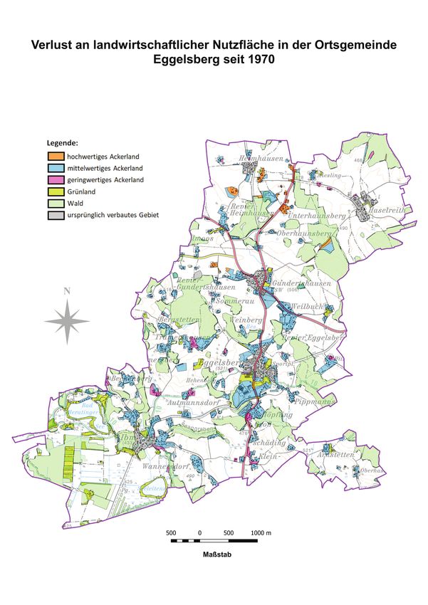
In Figure 2, the cropland that has been converted to local businesses and a large tannery. A decisive moment
other types of land use is indicated as high-quality crop- in the development of the village was the foundation of
land (brown), medium-quality cropland (blue), low-qual- an industrial enterprise in 1979 that has developed favora-
ity cropland (magenta), and grassland (yellow). The for- bly since then and led to a lasting increase and diversifica-
est area that is represented in light green shades has not tion of job opportunities. Structural change in the society
changed. The white areas represent cropland remaining as was reflected in the demand for the development of surface
cropland. area. Schools, recreation and shopping areas, residential
Table 1 presents a loss of agricultural land of 15% in areas, a sewage plant, and streets were built. This econom-
approximately half a century. The development of surface ically favorable development was possible at the expense
Table 1. Quantity of lost agricultural surface in 50 years in the community Eggelsberg
Tabelle 1. Bodenverlust in der Gemeinde Eggelsberg in 50 Jahren.
Area in the year 1970 (ha) Soil loss until 2020 (ha) Proportion of soil loss (%)
High-productivity cropland 96 11 11.5
Medium-productivity cropland 1,220 190 15.6
Low-productivity cropland 121 18 14.9
Grassland 409 63 15.4
Agricultural land 1,846 282 15.3
Die Bodenkultur: Journal of Land Management, Food and Environment 71 (2) 2020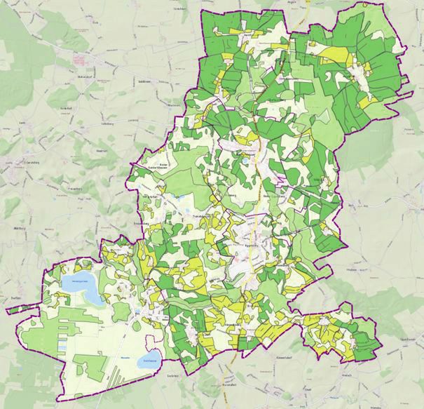
72                                                                   Günther Aust et al.

Figure 1. Original map of the Agricultural Soil Survey in the community Eggelsberg. Red lines delineate strata with similar soils (https://bodenkarte.at/).
Abbildung 1. Bodenkarte der landwirtschaftlichen Bodenkartierung der Gemeinde Eggelsberg. Die roten Linien bezeichnen Zonen mit gleichen
Bodenformen (https://bodenkarte.at/).

of agricultural soil (Haberl 2015). Overall, the converted                      in the village Ibm and, to a slightly lesser extent, in the vil-
agricultural land was put to use that meets the life style                      lage Gundertshausen. Evidently, there was no indication
and infrastructure expectations of the regional population.                     for unconstrained sprawl of the villages. Rather the villages
Two-thirds of the agricultural soils in the area had been                       grew gradually, and the claim of productive agricultural
qualified as medium quality in 1970 (Table 1). Owing to                         land was undisputed by the local population.
its origin from glacial and fluvial deposits, the soils have a                  The forest cover of approximately 20% of the area was
lower productivity compared with the classical agricultural                     mostly retained. The forests are owned by local farmers,
top soils in the east of the country. Soil quality has appar-                   and timber is used for the local demand of wood prod-
ently not played a major role in the land-use change in the                     ucts, bioenergy, and the traditional reserve for unexpected
past 50 years. The main share of agricultural soils lost was                    expenses. Heating systems based on wood chips are abun-
soils of medium quality, according to the soil evaluation of                    dant. A decentralized energy supply based on regionally
1970. Most of the now-sealed former agricultural land is                        available renewable resources is commonly found in farm
close to the center of villages, where the demand for new                       houses, because the fuel is available from silvicultural inter-
residential houses was satisfied. The village of Eggelsberg                     ventions. Forests traditionally occupy sites that are unsuit-
has grown considerably in the past 50 years, and the area                       able for agriculture, because of either the steepness of
of sealed surfaces for buildings and traffic space has dou-                     slopes or the low soil fertility. A peculiarity of the region is
bled. In the studied area, a similar development took place                     the forest cover of moist sites adjacent to peatland.
                                                                                As commonly found, there is not a sudden loss of soils
Table 2. Distribution of the area of the community Eggelsberg according to
                                                                                because of a single large project. Instead, the loss is gradual.
a recent evaluation of soils.                                                   A new house is built and, within a couple of years, both
Tabelle 2. Rezente Einschätzung der Bodenqualität in der Gemeinde               sides along a street are developed into residential areas; the
Eggelsberg.                                                                     old school is too small for modern demands, a new unit
                                          Area (ha)             %
                                                                                is erected with a school, a kindergarten, and retirement
                                                                                homes; a new supermarket outlet opens up.
 Forest land                                500                 21
                                                                                Soil scientists suggest reserving the productive agricultural
 Valuable cropland                          861                 36
                                                                                land in the region in order to ensure a sustainable food pro-
 Valuable grassland                         257                 11
                                                                                duction in Austria under warmer conditions. The agricul-
 Area of the community                     2,412
                                                                                tural sites in Upper Austria are presumingly less vulnerable

Die Bodenkultur: Journal of Land Management, Food and Environment                                                                             71 (2) 2020

Conversion of agricultural soils in Austria—a case study for a community in Upper Austria 73

Figure 2. Map of the village Eggelsberg. The grey shades represent the historic area of settlements and light green shades forest. The orange, blue,
and magenta shades represent now-sealed areas of high-, medium-, and low-productivity cropland, respectively, and the yellow shades represent
now-sealed areas of grassland.
Abbildung 2. Karte der Gemeinde Eggelsberg. Die grauen Zonen geben das Siedlungsgebiet von 1970 wieder. Die hellgrünen Flächen sind Wald.
Die Farbtöne Orange, Blau und Magenta repräsentieren jetzt verbaute Gebiete mit Ackerland mit hoher, mittlerer und niedriger Produktivität, und
die gelben Farbtöne repräsentieren jetzt versiegeltes Grünland.

Die Bodenkultur: Journal of Land Management, Food and Environment                                                                      71 (2) 2020
74 Günther Aust et al.
Figure 3. The evaluation of land of the community Eggelsberg according to the recent data. The light-green shades represent forest land, dark-green
shades highly productive agricultural land, and the yellow shades highly productive grassland.
Abbildung 3. Die Bewertung der Böden in der Gemeinde Eggelsberg auf Grundlage der rezenten Daten der Finanz-Bodenschätzung. Die hell-
grünen Flächen zeigen die Waldfläche, die dunkelgrünen Flächen zeigen wertvolles Ackerland und die gelben Flächen zeigen wertvolles Grünland.
to the effects of climate change than the agricultural sites cropland mostly in the north and east of the community of
in the East of Austria, where water shortage is expected to Eggelsberg. Valuable grassland was identified mostly in the
pose considerable problems in the future. A comparison of south of the community. So far, valuable agricultural land
Figure 3 and Tables 1 and 2 shows that the appreciation has been spared from soil sealing.
for the land quality in the region has changed. While the While the concerns about the future availability of agricul-
land was classified mostly as medium-quality agricultural tural land are at the agenda at the national level, it has not
land before 50 years, the recent map shows high-quality fully conveyed to the local actors. From the perspective of
Die Bodenkultur: Journal of Land Management, Food and Environment 71 (2) 2020
Conversion of agricultural soils in Austria—a case study for a community in Upper Austria 75
local residents and farmers, a critical shortage of fertile soils und Klimawandel – Herausforderung Klimaneutralität,
is not conceived. The land demand for residential build- November 26, 2019, Vienna.
ings, enterprises, shopping, and parking is given priority BMLFUW (2017): Geodatenkatalog des BMLFUW.
over abundant agricultural land. The high valorization of Übersicht über Geodatensätze in der GDI-L GDS. Bun-
the agricultural land from the viewpoint of scientists is not desministerium für Land- und Forstwirtschaft, Umwelt
evident for local farmers. The enterprise structure in the und Wasserwirtschaft, Wien.
areas follows the general trend in Upper Austria with a slow BVA (1976): Erläuterungen zur Bodenkarte 1:50 000,
decrease in the agricultural enterprises. Yet, the area of the Kartierungsbezirk Wildshut/Oberösterreich, KB 32.
agriculturally managed land remains almost unchanged Landwirtschaftlich-chemische Bundesversuchsanstalt.
because remaining farmers are buying or leasing the avail- Bodenkartierung und Bodenbewirtschaftung, Wien.
able agricultural land and are increasing their area of man- BMNT (2019): Bioeconomy – A strategy for Austria.
aged land (LWF, 2017). The potential future relevance of Bundesministerium für Nachhaltigkeit und Tourismus,
the agricultural soils is obviously not creating a credible https://www.bmnt.gv.at/umwelt/klimaschutz/biooe-
stimulus for actors in agriculture. konomie/BioÖkonomie-Strategie-für-Österreich.html.
The focus on local demand for land in order to build Accessed on 23 December 2019.
infrastructure and residential areas is not accounting for BMNT (2018): #mission2030 – Austrian Climate and
concerns on possible future shortages of productive land Energy Strategy. Bundesministerium für Nachhaltig-
for the provision of food, fodder, and fuel that is clearly keit und Tourismus, https://mission2030.info/wp-con-
expressed in a meta level (Foley et al, 2011, Gaupp et al., tent/uploads/2018/10/Klima-Energiestrategie_en.pdf.
2020). The societal demand for the production of biomass Accessed on 23 December 2019.
from regional land resources is not sufficiently reflected in Foley, J.A., Ramankutty, N., Brauman, K.A., Cassidy, E.S.,
land use regulations. Gerber, J.S., Johnston, M., Mueller, N.D., O’Connell,
C., Ray, D.K., West, P.C., Balzer, C., Bennett, E.M.,
Carpenter, S.R., Hill, J., Monfreda, C., Polasky, S.,
5. Conclusion Rockström, J., Sheehan, J., Siebert, J., Tilman, D. and
D.P.M. Zaks (2011): Solutions for a cultivated planet.
We assessed the change of land use during half a century in Nature 478, 337–342.
a community in Innviertel, Upper Austria. On the basis of Gaupp, F., Hall, J., Hochrainer-Stigler, S. and S. Dadson
the chemical and physical properties of soil, the land was (2020): Changing risks of simultaneous global bread-
mostly evaluated as medium productive 50 years ago. In basket failure. Nature Climate Change 10, 54–57.
the meantime, the effects of climate change have changed Haberl, H. (2015): Competition for land: A sociometa-
that view and have placed about 50% of the area of the bolic perspective. Ecological Economics 119, 424–431.
community under the category of preferential agricultural Haslmayr, H.-P. Baumgarten, A., Schwarz, M., Huber,
land. Yet, societal demands have led to a loss of approxi- S., Prokop, G., Sedy, K., Krammer, C., Murer, E.,
mately 15% of the agricultural land in the 50 years. Sell- Pock, H., Rodlauer, C., Schaumberger, A., Nadeem,
ing the land for settlement expansions was obviously more I. and H. Formayer (2018): BEAT – Bodenbedarf für
attractive than maintaining agriculture and conserving agri- die Ernährungssicherung in Österreich. Final Report
cultural land in order to meet future demands. Although Research Project No. 100975, Bundesministerium für
the expansion of the village was sensible and responsible, a Nachhaltigkeit und Tourismus.
considerable part of potentially valuable agricultural land Inspire (2020): Wertvolle landwirtschaftliche Produk-
was sacrificed. tionsflächen in Österreich. http://geometadatensuche.
inspire.gv.at/metadatensuche/srv/ger/catalog.search#/
metadata/2022c513-fc01-40b6-8841-0d176dd88ea4.
References Accessed 11 Feburary 2020.
KDZ Center for Public Administration Research (2020):
Baumgarten, A. (2019): Bodenbedarf für die Ernährungs- Offener Haushalt Eggelsberg. https://www.offener-
sicherung in Österreich. Lecture, presented at Austrian haushalt.at/gemeinde/eggelsberg. Accessed on 11 Feb-
Academy of Sciences at KIOES Workshop Landnutzung ruary 2020.
Die Bodenkultur: Journal of Land Management, Food and Environment 71 (2) 202076 Günther Aust et al.
LWF (2017): Grüner Bericht 2017. 34. Bericht über die Schadauer, K, Bauerhansl, C., Schöttl, S., Aufreiter, C.,
wirtschaftliche und soziale Lage der oberösterreichis- Löw, M. and A. Freudenschuss (2019): Die Fernerkund-
chen Land- und Forstwirtschaft in den Jahren 2014– ung als Schmuckstück der österreichischen Waldinven-
2016. https://gruenerbericht.at/cm4/jdownload/send/ tur. BFW Praxisinfo 50, 35–39.
11-gr-bericht-oberrreich/1890-oberoesterreich- Umweltbundesamt (UBA) (2019): Zwölfter Umwelt-
gb-2014-2016. Accessed on 23 December 2019. kontrollbericht. https://www.umweltbundesamt.at/
umweltsituation/umweltkontrollbericht/ukb/. Accessed
on 23 December 2019.
Die Bodenkultur: Journal of Land Management, Food and Environment 71 (2) 2020You can also read