HUMAN SETTLEMENT PLAN - MERAFONG CITY LOCAL MUNICIPALITY 2019 /20
←
→
Page content transcription
If your browser does not render page correctly, please read the page content below

HUMAN SETTLEMENT PLAN
         2019 /20

   MERAFONG CITY LOCAL
      MUNICIPALITY

                         1
CHAPTER 1
POLICY OVERVIEW
1.1 BACKGROUND
In terms of the National Housing Act, Act 107 of 1997, the Government’s primary
housing objective is to undertake housing development, which Section 1 defines as
follows:-
“the establishment and maintenance of habitable, stable and sustainable public and
private residential environments to ensure viable households and communities in areas
allowing convenient access to economic opportunities, and to health, educational and
social amenities in which all citizens and permanent residents of the Republic will, on a
progressive basis, have access to permanent residential structures with secure tenure,
ensuring internal and external privacy, and providing adequate protection against the
elements, potable water, adequate sanitary facilities and domestic energy supply.”
The existing national housing programs have been based on this objective and the
principles embodied therein. Municipalities are required to take the leading role in
negotiating the location of housing supply to facilitate spatial restructuring, spatial
planning and transportation systems and the integration of housing into municipal IDPs.
This entails the following:
Initiating, planning, facilitating and co-coordinating appropriate housing development
Implement projects as developers in accordance with agreements
Promote private sector development
Develop a housing delivery strategy with development goals
Planning and allocation of land for human settlements
Creating a financially and socially viable environment for housing delivery
Facilitating the resolution of conflicts arising from housing delivery initiatives
Facilitating the provision of bulk services
Administering national housing programs.
Expropriating land for housing development.
The plan addresses the following:
key principles - housing planning as part of IDP
an overview of the local context;
an information regarding current housing demand;
identification of land suitable for future housing development;
overview of the current housing situation;
information regarding planned projects;
strategic delivery thrust: housing supply options
2
1.2 KEY PRINCIPLES - HOUSING PLANNING AS PART OF IDP

    Strategic Overview

    The human settlement department is delivered on its mandate through various programs
    that aim to provide a holistic approach to service delivery in Human Settlements. The
    work is guided by Outcome 8: sustainable human settlement ad improved quality of
    household life and the Ten Pillar Programme on modernization of Human Settlement
    and Urban Development

    Linked to the Human Settlement and Urban Development are the issues of poverty
    reduction, job creation, training and skill development. As government we have an
    obligation to ensure that our people benefit from human settlement development through
    the employment of the employment of the principles of the Expanded Public Works
    Programme (EPWP) and Community Works Programme.

    Underlying the approach to housing planning as part of integrated development planning
    are a set of key principles that emerged from considering strategic concerns in respect
    of the housing sector as well as the intergovernmental planning and implementation
    system. These are indicated and elaborated upon below.

    1.2.1   Sustainable human settlement development and asset creation

            Building human settlements goes beyond the production of houses and should
            ensure the integrated delivery of a wide range of social and economic amenities
            and infrastructure that ensure a supportive context for sustainable livelihoods
            and a strong civil society. This relates to the shift in policy from shelter provision
            to sustainable human settlements and communities, and the improvement of the
            quality of the housing products and residential environments produced through
            the programme.

    1.2.2   Strategic concern for demand-defined and supply negotiated housing delivery

            Development, which is demand-defined (by households according to their
            needs, and through local government-based processes such as the IDP
            process) and is supply-negotiated, should be promoted. Supply negotiation
            should take place at the local sphere of government. Supply negotiated housing
            delivery is a means to ensure that housing policy and implementation provides a
            way, for the state to engage with communities and households, whereby
            demand-definition and supply-negotiation ensure that people living in situations
            of poverty are better able to build social and physical assets, thus enhancing
            housing as an economic instrument once transferred.

    1.2.3   Restructuring of the institutional architecture for housing

            Housing demands need to be addressed by coordinated and integrated
            planning, funding and capacity building efforts at different spheres and sectors
            of government. The notion of supply actors need to be broadened to leverage
            individual and collective responsibility for meeting the housing demand and the
            need to mobilize and enable new actors to perform these roles.

                                                                                                3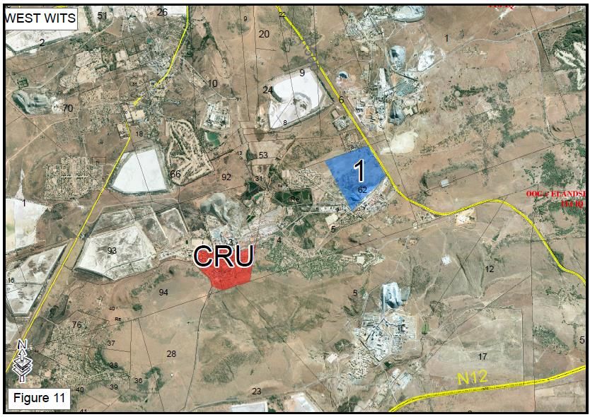
1.2.4   Transformation of the intergovernmental planning and fiscal system

            Housing policy instruments and their implementation agencies need to be
            aligned to ensure better flow of funds and more effective achievement of desired
            outcomes. Housing planning as part of IDPs will form the basis for multi-year
            provincial housing plans, thereby improving planning.

            This strategic plan focuses on the implementation of the housing programme in
            accordance with the Integrated Development Plan of Council and to adjust the
            housing strategy and targets with policy directives.

                                         CHAPTER 2
              OVERVIEW OF THE LOCAL CONTEXT
2.1. LOCALITY

    Merafong City Local Municipality is located within the southwestern portion of the
    Gauteng Province. The Municipal Area is connected to the rest of Gauteng and
    neighboring Provinces through the N12, N14 and R500 that traverses the Municipal
    area.

                   Figure 1

    Merafong City is characterized by a number of settlements scattered throughout the
    Municipal Area. This scattered settlement pattern is largely due to mining activities
    concentrated along the mining belt running through the center of the Municipal Area.
    The primary settlements within the Municipal Area can therefore be divided into 3 sub-
    regions, being the northern conurbation, mining belt, and southern conurbation. The
    northern conurbation consists of Carletonville, Khutsong, Welverdiend and Blybank. The
    southern conurbation consists of Fochville, Kokosi and Greenspark, whereas Wedela,
    and the following mining villages are located within the mining belt:

                                                                                          4
o    West Wits
      o    East & West Driefontein
      o    Elandsridge
      o    Deelkraal
      o    Blyvooruitzicht
      o    Doornfontein

      Figure 2 below, indicates the primary settlements within the Municipal area and the three
      divided sub-regions.

                                                                   Northern Conurbation

                                                                             Mining Belt

                                                                             Southern Conurbation

              Figure 2

2.2       SITUATIONAL ANALYSIS

      South Africa is characterized by long-established patterns of intra-regional migration,
      with countries sending and receiving labour migrants especially for employment in mines
      and on commercial farms since the late nineteenth century.

      These patterns and processes have undergone notable change in recent decades, the
      outcome being a progressive intensification of mobility in the Gauteng Province. The
      underlying determinants of this trend include increased and new opportunities for
      internal and cross-border movement following the end of apartheid, the Gauteng’s
      increasing engagement with the global economy, persistently high and worsening levels
                                                                                               5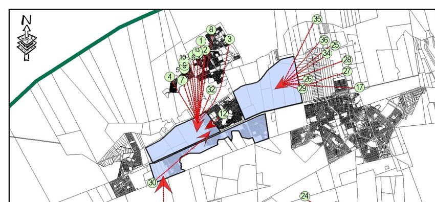
of poverty and unemployment, the impact of the HIV/AIDS pandemic, and the
displacement and forced migration borne out of conflict and civil strife.
Merafong City as a predominant mining community is also characterized by the
migration patterns linked to the mining industry. This has led to the growing informal
settlements.
A socio-economic analysis of informal settlements in Merafong City has revealed that 3
distinguishable groups exist:
People living on the fringes of townships,
People living close to mine shafts, and
People living on farms, not associated with those localities mentioned above.
2.3 INFORMAL SETTLEMENTS LOCALITY
Figure 3 gives an indication on the locality of the various informal settlements within the
Municipal Area.
2.4 SOCIO ECONOMIC PROFILE
The socio economic profile of informal settlements within the northern conurbation
(Khutsong area), southern conurbation (Kokosi area) and the mining belt, based on
Census 2011, is reflected below. The socio- economic factors below is significant in the
planning and determination of the different housing typologies needed in the respective
areas.
6
Age distribution.
                         Age distribution
                                                                       The       age      distribution
80 - 120
                                                                       between the townships and
                                                                       the mine settlements are
 70 - 79                                                               clearly visible in the figure
 60 - 69                                                               left. As indicated by the
                                                                       black arrows, the proportion
 50 - 59
                                                           Mining      of     economically      active
 40 - 49                                                               people      in    the     mine
                                                           Kokosi
 30 - 39                                                               settlements is far greater
                                                           Khutsong    than that of the townships.
 20 - 29                                                               Furthermore the proportion
 10 - 19                                                               of children and the elderly in
                                                                       the mine settlements is
     0-9
                                                                       significantly lower.
             0       10         20       30           40

                                                                       Household size.
                         Household size
                                                                       Approximately     55%    of
60                                                                     households      in    mine
                                                                       settlements consist of a
50
                                                                       single person as opposed to
40                                                                     38% of the township
                                                           Khutsong    settlements.
30
                                                           Kokosi
20                                                         Mining

10

 0
         1       2   3      4    5   6        7   8

                                                                        Gender
                                Gender
70.00%                                                                  As can be expected the
60.00%                                                                  gender ratio in the mining
50.00%                                                                  settlements is skewed
40.00%                                                      Khutsong    towards more men. There
30.00%                                                      Kokosi      are almost 20% more men
20.00%                                                                  than women in these
                                                            Mining
10.00%
                                                                        informal settlements.
 0.00%
                     Male                Female

                                                                                                    7
Individual monthly income
16000
14000
12000
10000
 8000
 6000
                                                                                                                                                                                                                                                                               Khutsong
 4000
 2000                                                                                                                                                                                                                                                                          Kokosi

    0                                                                                                                                                                                                                                                                          Mining
                                  R 401 - R 800

                                                  R 801 - R 1 600

                                                                                                                                                                             R 51 201 - R 102 400
                                                                    R 1 601 - R 3 200

                                                                                        R 3 201 - R 6 400

                                                                                                                                                                                                                            R 204 801 or more
        No income

                    R 1 - R 400

                                                                                                                                                                                                    R 102 401 - R 204 800
                                                                                                            R 6 401 - R 12 800

                                                                                                                                 R 12 801 - R 25 600

                                                                                                                                                       R 25 601 - R 51 200

                                                                                                                                                                                                                                                              Not applicable
                                                                                                                                                                                                                                                Unspecified
    Individual monthly income.

    The table above reflects the income level. The majority of residents in informal
    settlements earn between R0 and R3200 per month, whilst a number of residents earn
    between R3200 and R10 000 per month. The assumption that all people living in
    informal settlements are indigent is therefore incorrect and has a serious impact on the
    planning for housing provision for these informal settlements.

2.5 DEDUCTION:

    The following inference can be made from census surveys conducted within the various
    informal settlements in the Municipal Area:

    1) According to the age distribution, approximately 57% of the population in the mining
       informal settlements falls within the economically active age group and
       approximately 55% of these households consist of 1 person. The most suitable
       housing typology to address this housing need is therefore the provision of rental
       accommodation. This is further supported by the fact that mineworkers do receive a
       living out allowance which is suitable to pay for proper rental accommodation,
       should it be provided.

    2) The household size of 43% of all the informal settlement households within the
       Municipal area, consist of 1 person, indicating that migrant workers seeking job
       opportunities are the main cause for informal settlements.

    3) According to the gender distribution, there is on average almost 40% more males
       than females within the informal settlements, which confirm the high occurrence of
       migrant workers staying in informal settlements.

                                                                                                                                                                                                                                                                                          8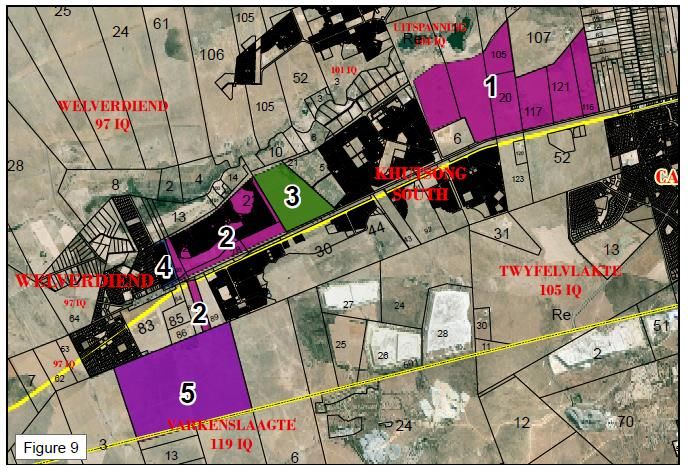
4) A large number of 20,880 households in the northern conurbation earns less than
   R3200 per month, and therefore confirms the need for Government subsidised
   housing.

5) A large number of approximately 2,000 households in the mining informal
   settlements have reported no form of income.

6) A large percentage of people living in mining informal settlements earns above the
   threshold qualifying for Government subsidised housing and should be
   accommodated through proper rental accommodation. The fact that most are
   migrant workers despite being able to afford own accommodation, contributes
   thereto that they do not enter the property market in Merafong City, but rather invest
   in their place of origin.

7) The need for integrated development to integrate mining informal settlements into
   formal towns with access to schools, clinics, shops and public transport is confirmed
   by the above socio economic analysis.

8) In situ development of informal settlements in close proximity to mine shafts would
   not be sustainable and should not be considered as a long term solution.

9) Mining companies and associated contractors should ensure that appropriate
   housing accommodation is provided for their workers. Participation and investment
   in integrated housing development rather than continuing with housing provision on
   mine properties should be encouraged.

                                                                                       9
CHAPTER 3
HOUSING DEMAND
Merafong City is characterized by a number of settlements scattered throughout the Municipal
Area. The fragmented settlement pattern is largely due to mining activities concentrated along
a mining belt running through the center of the Municipal Area. The mines have stimulated the
development of numerous smaller settlements at the mine shafts that are located along this
belt.
Housing delivery in Merafong City focusses on the following needs:
State funded, low cost housing.
Private sector developments targeting mainly mixed, middle to upper income groups.
Affordable rental accommodation and social housing.
Informal settlement up-grade.
The housing plan considers the full range of housing products and land which is suitable for
such products.
Figure 3 gave an indication on the locality of the various informal settlements throughout
Merafong City. For ease of reference, the housing demand will be discussed per sub-region.
3.1 NORTHERN CONURBATION
As indicated earlier, the northern conurbation consists of the Carletonville, Khutsong,
Welverdiend and Blybank areas. The majority of informal settlements are located on the
periphery of Khutsong and the rural areas surrounding Carletonville, as indicated below.
Figure 4
10The table below indicates the detail per individual informal settlement, as indicated on Figure 4 above.
Location as per co- Classification
In-situ Upgrade
Vulnerabilities
ordinates A: Urgent
Relocation
Sanitation
Name of Numb relocation
Nearest required
Informal Land Owner er of Water Lighting
suburb B: short-medium
Settlement units
term plan
S E C: No short-
medium term
plans
Sonderwater 26° 19' 27° 18'
Khutsong Merafong 2010 no Yes B High masts
Map ref.(1)
13.305" S 57.142" E standpipes VIP Dolomite
Rivonia Gauteng
Khutsong 26° 19' 27° 18' 734 no yes B High masts
Map ref.(10) Government
46.908" S 27.142" E standpipes VIP Dolomite
Rest in Peace
Khutsong 26° 19' 27° 18' Merafong 151 no yes B High masts
Map ref. (11)
34.671" S 52.360" E standpipes VIP Dolomite
Cross Roads 26° 19' 27° 18'
Khutsong Merafong 558 no Yes B High masts
Map ref. (13)
30.834" S 51.010" E standpipes VIP Dolomite
B-Section
Khutsong 26° 19' 27° 19' Merafong 540 no Yes B High masts
Map ref.(2)
28.266" S 4.811" E standpipes VIP Dolomite
Mandela
Section Khutsong 26° 19' 27° 19' Merafong 830 no Yes B High masts
Map ref.(3) 10.583" S 48.710" E standpipes VIP Dolomite
Joe Slovo Gauteng
Khutsong 26° 20' 27° 18' 1 680 no Yes B High masts
Map ref. (4) Government
12.680" S 1.390" E standpipes VIP Dolomite
Chris Hani 26° 19' 27° 18' Gauteng
Khutsong 1 080 no Yes B High masts
Map ref. (5) 59.474" S 27.295" E Government standpipes VIP Dolomite
Phola Park 26° 19' 27° 18'
Khutsong Merafong 541 no Yes B High masts
Map ref.(6) 36.565" S 43.990" E standpipes VIP Dolomite
T-Section Gauteng
Khutsong 26° 19' 27° 18' 899 no Yes B High masts
Map ref. (9) Government
53.678" S 28.041" E standpipes VIP Dolomite
Chiawelo
Khutsong 26° 18' 27° 19' Merafong 687 no Yes B High masts
Map ref. (8)
54.585" S 15.831" E standpipes VIP Dolomite
Ptn 3 of the
farm
Gauteng
Stinkhoutboom Khutsong 43 no Yes B No
Government
101 IQ 26° 20' 27° 19'
Map ref. (32) 33.812" S 15.999" E standpipes VIP Dolomite
11Classification
A: Urgent
In-situ Upgrade
Vulnerabilities
relocation
Relocation
Sanitation
Name of Numb required
Nearest Location as per co-
Informal Land Owner er of B: short-medium Water Lighting
suburb ordinates
Settlement units term plan
C: No short-
medium term
plans
Khutsong Ext
3 Khutsong 26° 20' 27° 18' Merafong 479 yes B Standpipe Commu High masts
Map ref.(7) 17.911" S 23.855" E s nal Dolomite
Khutsong water
South:- back Khutsong connection
Merafong 323 no Yes B yes
yard dwellers South 26° 21' 27° 19' :- house flush
Map ref.(12) 13.110" S 37.624" E tap toilets Dolomite
Ptn 4 of farm
Wonderfontein
Carletonville FWRDWA 26 no Yes C no
103 IQ 26° 19' 27° 22'
Map ref.( (25) 19.764" S 58.811" E jo-jo tenks no Dolomite
Ptn 61 of the
farm
Wonderfontein Carletonville Living Gold 249 no Yes C no
103 IQ 26° 20' 27° 22'
Map ref. (26) 15.386" S 10.022" E jo-jo tenks no Dolomite
Ptn 31 of the
farm
Wonderfontein Carletonville FWRDWA 48 no Yes C no
103 IQ 26° 20' 27° 23'
Map ref. (27) 2.486" S 20.427" E jo-jo tenks no Dolomite
Ptn 129 of the
farm
Wonderfontein Carletonville FWRDWA 65 no Yes C no
103 IQ 26° 19' 27° 23'
Map ref.(28) 44.032" S 21.219" E jo-jo tenks no Dolomite
Ptn 22, 57, 59
& 1 of the farm
Wonderfontein Khutsong FWRDWA 103 no Yes C no
103 IQ 26° 20' 27° 22'
Map ref.(29) 31.339" S 0.191" E jo-jo tenks no Dolomite
Ptn 3 of the
farm
Carletonville FWRDWA 46 no Yes C no
Wonderfontein 26° 19' 27° 22'
103 IQ (36) 11.300" S 39.055" E jo-jo tenks no Dolomite
Ptn 108 of
farm
Carletonville FWRDWA 43 no Yes C no
Wonderfontein 26° 18' 27° 22'
103 IQ (35) 37.135" S 26.494" E jo-jo tenks no Dolomite
12Classification
A: Urgent
In-situ Upgrade
Vulnerabilities
relocation
Relocation
Sanitation
Name of Numb required
Nearest Location as per co-
Informal Land Owner er of B: short-medium Water Lighting
suburb ordinates
Settlement units term plan
C: No short-
medium term
plans
Ptn 37 of the
farm
Wonderfontein Khutsong RSA 134 no Yes C no
103 IQ 26° 19' 27° 22'
Map ref. (34) 33.128" S 44.099" E jo-jo tenks no Dolomite
Ptn 96 of the
farm Khutsong
Stoch + 22
Welverdiend South 12 no Yes C no
owners
97 IQ Extensions 26° 23' 27° 17'
Map ref. (30) 7.144" S 30.660" E no no Dolomite
Ptn 35 of the
farm
Wonderfontein Carletonville RSA 134 no Yes C no
103 IQ 26° 19' 27° 22'
Map ref. (34) 33.128" S 44.099" E jo-jo tenks no Dolomite
Ptn 9 of the
farm
Carletonville 40 no Yes C no
Wonderfontein 26° 19' 27° 22'
103 IQ 33.128" S 44.099" E jo-jo tenks no Dolomite
Ptn 113 of the
farm
Carletonville 13 no Yes C no
Wonderfontein 26° 19' 27° 22'
103 IQ 33.128" S 44.099" E jo-jo tenks no Dolomite
Ptn 72 of the
farm
Carletonville 2 no Yes C no
Wonderfontein 26° 19' 27° 22'
103 IQ 33.128" S 44.099" E jo-jo tenks no Dolomite
Ptn 106 of the
farm
Carletonville 21 no Yes C no
Wonderfontein 26° 19' 27° 22'
103 IQ 33.128" S 44.099" E jo-jo tenks no Dolomite
Ptn 109 of the
farm
Carletonville 134 no Yes C no
Wonderfontein 26° 19' 27° 22'
103 IQ 33.128" S 44.099" E jo-jo tenks no Dolomite
Ptn 24 of the
farm
Carletonville 30 no Yes C no
Wonderfontein 26° 19' 27° 22'
103 IQ 33.128" S 44.099" E jo-jo tenks no Dolomite
Ptn 3 of the
farm Rooipoort Carletonville 26° 19' 27° 22' 25 no Yes C no
109 IQ 33.128" S 44.099" E jo-jo tenks no Dolomite
13Classification
A: Urgent
In-situ Upgrade
Vulnerabilities
relocation
Relocation
Sanitation
Name of Numb required
Nearest Location as per co-
Informal Land Owner er of B: short-medium Water Lighting
suburb ordinates
Settlement units term plan
C: No short-
medium term
plans
Ptn 69 of 26° 19' 27° 22'
Carletonville 18 no Yes C no
Waters’ Edge 33.128" S 44.099" E jo-jo tenks no Dolomite
Total 11698
As can be seen from the above table, there are 11 698 informal settlement households within the northern conurbation. The
informal settlements located on the periphery of Khutsong have access to basic services, such as water, sanitation and high
mast lighting, whereas the informal settlements located on farm land around the Carletonville area, basically only have
access to water and basic sanitation.
All of these areas are however subject to dolomite conditions, and in terms of SANS 1936, no informal structures may be
permitted on dolomitic land. In situ development of these informal settlements is therefore not an option, and all of these
informal settlements need to be relocated to suitable safe land.
As indicated in Figure 4, all of these informal settlements have been earmarked for relocation to the Khutsong South
Extensions Development. It is estimated that approximately 20% of the total 11 698 informal households will not qualify for
subsidized housing, due to nationality, income and other reasons, and can therefore be accommodated in a transit area or
rental accommodation.
In terms of the housing plan, the housing demand of 11 698 households in the northern conurbation can be addressed as
follows:
14NORTHERN CONURBATION
Residential stands planned to serve, actual no. of residential stands served, estimated capital New Bulk infrastructure, capital costs and rehabilitation of bulk infrastructure
Baseline information
and rehabilitation costs (excluding bulk) required
(Residential Development)
No. of Baseline: list No. of erven planned to Estimated new capital costs (R Value) Top structure costs per Specify Bulk infrastructure Bulk infrastructure
SPACE DEVELOPMENT
households number of process/approve per annum (R52,564) annum (Roads & storm water: R4,7 mil/km & 0,013km/erf capital costs (R -000
in the houses (Please note: private developers are (DoHS) (R73 309.75) Value) per annum
municipalit required to responsible for installation of internal excl. Professional fees
y (at a eliminate services)
growth backlogs in
rate of terms of new
1, 25% p.a.) residential
areas
73451 15024 Khutsong South Ext 5 Khutsong Bulk Pipe Line -= R25,000,000
Phase 2 (Roll over from 55 573 500
18/19) (500)
Khutsong South Ext 5 R58,000,000
Phase 2 (500)
Khutsong South Ext 5 TBA
Year 1 (19/20)
Private Development
(253)
Khutsong South Ext 5 R65,631,245
Phase 3
(1320)
Elijah Barayi Electricity: New Khutsong South Bulk substation +
Phase 1 TBA 11Kv main substation
(1601)
Water: Construction of 10,8 Ml Reservoir
R68,770,000
76383 13 010 Remainder of Khutsong R199,596,250 WWTP: Carletonville 7,5Ml
Year 2 (20/21)
South Ext 7 R98,500,000
(1250)
Elijah Barayi TBA
(Phase 2)
(2500)
80434 9914 Carletonville Ext 7 R20,000,000
(2290)
(21/22)
Year 3
Khutsong South Ext 8
(9000)
85189 6164 Elijah Barayi TBA Roads & storm water: 12km
(Phase 4)
(22/213
Year 4
(8599)
153.2 SOUTHERN CONURBATION
The southern conurbation consists of the Fochville, Kokosi and Greenspark areas. The
majority of informal settlements are located in and around Kokosi, on the periphery of
Greenspark and in the farming areas surrounding Fochville.
The location of these informal settlements is indicated on the map below:
Figure 5
The table below indicates the detail per individual informal settlement, as indicated on Figure
5 above.
16Classification
A: Urgent
In-situ Upgrade
Vulnerabilities
relocation
Relocation
Sanitation
Name of Numb required
Nearest Location as per co-
Informal Land Owner er of B: short-medium Water Lighting
suburb ordinates
Settlement units term plan
C: No short-
medium term
plans
Extension 99,
Kokosi Kokosi 26° 30' 27° 27' Merafong 1897 no Yes B flush High masts
Map ref.(14) 57.191" S 51.837" E yard tap toilets water table
Between Kokosi
Ext 2 & Kokosi
Kokosi Merafong 489 no Yes B High masts
Ext 1 26° 29' 27° 28' 5.262" Eskom
Map ref. (15) 37.865" S E no buckets servitude
Greenspark
graveyard Greens park 26° 29' 27° 30' Merafong 437 no Yes B No
Map ref. (16) 53.598" S 39.925" E no VIP grave yard
Smith farm 26° 25' 27° 31'
Greens park Pelser & de Wet 14 no Yes C No
Map ref.(18) 51.981" S 37.221" E no no
near Kraalkop
Hotel Fochville 26° 26' 5.090" 27° 30' Kraalkop hotel 11 no Yes C No
Map ref. (19) S 19.932" E no no
2848
Total
As can be seen from the above table, there are 2848 informal settlement households within the southern conurbation. The informal
settlements located in and around Kokosi and on the periphery of Greenspark have access to basic services, such as water,
sanitation and high mast lighting, whereas the informal settlements located on farm land around the Carletonville area, basically
only have access to water and basic sanitation.
As indicated above, all of these informal settlements need to be relocated. Kokosi Extension 99 will always have to remain a transit
area, as the water table is too high and township establishment cannot be considered. The other area
s is either affected by servitude areas, graveyards or private properties, and in situ development cannot be considered.
As indicated in Figure 5, all of these informal settlements have been earmarked for relocation to Kokosi Extension 6 and 7 or
Greenspark Extension 1 areas. The households that do not qualify for subsidized housing will have to be accommodated in other
forms of housing typology, such as bonded houses, rental stock or social housing.
In terms of the housing plan, the housing demand of 2848 households in the southern conurbation can be addressed as follows:
17SOUTHERN CONURBATION
Residential stands planned to serve, actual no. of residential stands served, estimated New Bulk infrastructure, capital costs and rehabilitation of bulk infrastructure
Baseline information
(Residential Development)
capital and rehabilitation costs (excluding bulk) required
SPACE DEVELOPMENT
No. of Baseline: list No. of erven Estimated new capital costs (R Value) per Top structure Specify Bulk infrastructure Bulk infrastructure capital
households number of houses planned to annum costs per (Roads & storm water: R4,7 mil/km & 0,013km/erf costs (R -000
in the required to process/approve (Please note: private developers are annum Value) per annum
municipalit eliminate responsible for installation of internal (DoHS)
y (at a backlogs in terms services) excl.
growth rate of new residential Professional
of areas fees
1,25% p.a.)
73451 667 Kokosi Ext 7 TBA Water: Bulk water supply pipeline
(3120)
(19/20)
Year1
Fochville Ext 11 R13,533,980
(Private
Development)
(258)
76269 4779 Wedela Ext 4 TBA
(464) WWTP: Standby generator
WWTP: sludge drying equip
WWTP: Concrete lining sludge
Year 2 (20/21)
Fochville Ext 7 TBA WWTP: Concrete fencing
(3120) Sewer: Bulk sewerage pump stations & raising
R155,128,397 main
Sewer: Phase 1 upgrade of WWTP to 11,7ML (R74
Fochville Ext 8 TBA mil)
(256) Roads & Storm water: 24,55km (R115,385 mil)
Electricity: Upgrade Fochville Main Substation
76325 4541 Kokosi Ext 7 TBA
Year 3 (21/22)
(3120)
Fochville Ext 12 and
14 (220)
76325 4541 Kokosi Ext 7 R321,213,360
(3120)
Year 4 (22/23)
Fochville Ext 17
(165) and 18 (195)
183.3 MINING BELT
The mining belt consists of Wedela, and the following mining villages are located within
the mining belt:
o West Wits
o East & West Driefontein
o Elandsridge
o Deelkraal
o Blyvooruitzicht
o Doornfontein
The location of these informal settlements is indicated on the map below:
31
Figure 6
The table below indicates the detail per individual informal settlement, as indicated on Figure
6 above.
19Classification
A: Urgent
In-situ Upgrade
Vulnerabilities
relocation
Relocation
Sanitation
Name of Numb required
Nearest Location as per co-
Informal Land Owner er of B: short-medium Water Lighting
suburb ordinates
Settlement units term plan
C: No short-
medium term
plans
Mohaleshoek Western 26° 25' 4.125" 27° 26' Freishlich 729 No Yes B no
Map ref.(33) Deep Levels S 16.967" E jo-jo tenks VIP Dolomite
Near Nr 9
Western Pins Trading Pty
Hostel 26° 24' 27° 24' 189 No Yes B no
Deep Levels Ltd
Map ref.(21) 26.395" S 40.751" E no no Dolomite
Near
Slimesdam, Blyvooruitzic Blyvooruitzicht
278 No Yes C no
Blyvooruitzicht ht 26° 23' 27° 22' 4.892" gold Mine
Map ref. (24) 28.101" S E no no Dolomite
Camp 1, East
East
Driefontein 26° 24' 27° 30' 7.502" 9 owners No Yes C no land
Driefontein
Map ref.(22) 37.448" S E jo-jo tenks VIP availability
4600
Camp 2, East
East Malhil Trading
Driefontein 26° 23' 27° 30' No Yes C no land
Driefontein Group
Map ref.(23) 57.316" S 27.844" E jo-jo tenks VIP availability
next to
Deelkraal shaft Deelkraal 26° 25' 4.702" 27° 17' Moria mining 6 No Yes C no land
Map ref.(31) S 52.505" E no no availability
South of
Randfontein
Wedela Wedela Ext 2 26° 28' 5.310" 27° 23' 462 No Yes C no land
Estates Ltd
Map ref.(20) S 31.573" E no no availability
6264
Total
As can be seen from the above table, there are 6264 informal settlement households within the mining belt. The informal
settlements located at Blyvooruitzicht, and Western Deep Levels, can be accommodated at the West Wits Township, either
through subsidized housing or the CRU project.
The informal settlement at Deelkraal can be accommodated at Deelkraal itself through the CRU project by Harmony Gold, or
accommodated in a subsidized housing project in Wedela Extension 4.
20The informal settlements at East Driefontein created problems for both Goldfields Mining
Company and the Municipality for many years. Based on the location of East Driefontein
Village, and in terms of the concept and requirements for sustainable settlements, and in
terms of the Merafong City SDF, the informal settlements at Driefontein cannot be
formalized. In view of the fact that East Driefontein is a mining village and not a proclaimed
township, the informal settlements have to be relocated to the Khutsong area. The area
indicated in Figure 7 has been earmarked for this purpose.
Figure 7
In terms of the housing plan, the housing demand of 6264 households in the mining belt can
therefore be addressed as follows. It is however important to note, that the 4600 informal
settlement households of the East Driefontein area will have to be accommodated in the
northern conurbation as a Presidential Package:
21MINING BELT
Residential stands planned to serve, actual no. of residential stands served, estimated capital New Bulk infrastructure, capital costs and rehabilitation of bulk infrastructure
Baseline information
(Residential Development)
and rehabilitation costs (excluding bulk) required
SPACE DEVELOPMENT
No. of Baseline: list No. of erven planned to Estimated new capital costs (R Value) Top structure costs per Specify Bulk infrastructure Bulk infrastructure
households number of process/approve per annum (R52 564.50) annum (Roads & storm water: R4,7 mil/km & 0,013km/erf capital costs (R -000
in the houses required (Please note: private developers are (DoHS) Value) per annum
municipalit to eliminate responsible for installation of internal R 73 309.75 T/Structure
y (at a backlogs in services)
growth rate terms of new
of 1,25% residential
p.a.) areas
73451 1104
Year 1 (2019/20
74369 1104 Blybank R26,282,250 R55,473,500
Year 2 (20/21)
(500)
77161 -758 No Projects planned
Year 3(21/22)
22CHAPTER 4
LAND IDENTIFICATION
It is important that the Housing Plan should be implemented in accordance with the
priorities indicated in the Spatial Development Framework. The SDF Sector Plan is
informed by a two main spatial concepts.
Integrated development
All new housing developments should be done in an integrated manner to ensure
sustainability and social cohesion. The fragmented human settlements and informal
settlements exacerbated by mining developments should be phased out in an
integrated manner, providing mixed land users within urban nodes.
Densification
Densification is aimed at avoiding urban sprawl and encouraging a compact town/city.
A compact town/city is characterized as being dense, socially diverse and
overlapping in terms of economic and social activities within the town/city.
The following land has been identified in the Municipal area for Integrated Human
Settlement Development, to address the housing need within the respective housing
typologies required.
Figure 8
23Northern conurbation
Timeframe Short Term Medium term Total
2016/17 – 2017/18 2018/19 – 2020/2021
Land parcel 2 5 2 3 4 5
Housing Housing Need
Typology Total: 15024
RDP 361 261 1250 1500 3011
GAP 253 253
FLISP 400 2000 2400
MIXED 2500 2500
TOTAL 361 400 261 1250 253 6000 8164
24PLANNED LAND ACQUISITION FOR HUMAN SETTLEMENTS: NORTHERN CONURBATION
5 YEAR TARGETS
STATUS OBJECTIVE PERFORMAN BASELINE
QUO CE
YEAR 1 YEAR 2 YEAR 3 YEAR 4 YEAR 5
INDICATOR
2016/17 2017/18 2018/19 2019/20 2020/21
Informal Purchase Additional Land Required for Township Land
Settlements Establishment: Acquisition
(nr of units):
Northern Khutsong South Ext 4: (148 houses) R 200,000
Conurbation Re of Ptn 43 of Wvd 97 IQ (25,8887 ha)
+ Mining Khutsong South Ext 3: (900 houses) R8,226,374
Belt Ptn 123 (ptn of Ptn 20) of Wonderfontein
=18 379 103 IQ
(56,2093 ha)
Ptn 120 (ptn of Ptn 20 of Wonderfontein 103
IQ
(8,5653 ha)
Khutsong South Ext 8: (8080 houses) R9,145,891
Re/Ptn 89 (ptn of Ptn 13) of Wvd 97 IQ
(23,2651 ha)
Ptn 87 (ptn of Ptn 12) of Wvd 97 IQ
(13,6049 ha)
Ptn 86 (ptn of Ptn 12) of Wvd 97 IQ
(12,8480 ha)
Ptn 85 (ptn of Ptn12) of Wvd 97 IQ
(16,6282 ha)
Ptn 84 (ptn of Ptn 12) of Wvd 97 IQ
(5,6687 ha)
Khutsong South Ext 9: (9000 houses)
RE of Uitspanning aan Wonderfontein 104 IQ
(61,0605 ha) Request for
RE Ptn 1 of Uitspanning aan Wonderfontein 104
Donation:-
IQ
(92,9243 ha) FWRDWA
RE Ptn 20 of Wonderfontein 103 IQ (55,1393 ha)
RE Ptn 105 of Wonderfontein 103 IQ (36,4832 ha)
25 RE Ptn 107 of Wonderfontein 103 IQ (134,6482 ha)
RE Ptn 115 of Wonderfontein 103 IQ (23,4324 ha)
RE Ptn 116 of Wonderfontein 103 IQ (43,7558 ha)
RE Ptn 117 of Wonderfontein 103 IQ (58,1384 ha)
RE Ptn 121 of Wonderfontein 103 IQ (40,1843 ha)
26Southern conurbation
Timeframe Short Term Total
2017/18 – 2018/19
Land parcel Kokosi Ext 6 Kokosi Ext 7
(1) (2)
Housing Housing Need
Typology Total: 6679
RDP 2138 3120 5258
GAP
CRU
TOTAL 2138 3120
27Mining belt
28Mining Belt
Timeframe Short Term Total
2016/17 – 2017/18
Land Blybank Wedela Deelkraal West Wedela West Wits
(Sibanye) (Anglo) CRU Wits Ext 4 (1)
parcel CRU (2)
Housing Housing
Typology Need
Total:
1104
RDP 464 464
GAP 50 50 500 600
CRU 648 250 898
TOTAL 100 1862 1962
Sufficient land has been identified in all three development areas of Merafong City to
address the total housing need over a five year planning framework. The implementation of
the plan is however dependent on funding allocation from the National and Provincial
Department of Human Settlements.
29PLANNED LAND ACQUISITION FOR HUMAN SETTLEMENTS: MINING BELT
5 YEAR TARGETS
STATUS OBJECTIVE PERFORMA BASELINE
QUO NCE
INDICATOR YEAR 1 YEAR 2 YEAR 3 YEAR 4 YEAR 5
2016/17 2017/18 2018/19 2019/20 2020/21
Informal Purchase Additional Land Required for Land
Settlements Township Establishment: Acquisition 270 ha
Southern Wedela Ext 4: Deed of 464 stands
Conurbation Ptn of Ptn 78 of Buffelsdoorn 143 IQ Donation:-
(±270 ha) Harmony
SLP
30CHAPTER 5
IMPLEMENTATION PRIORITIES
IMPLIMENTATION PRIORITIES
1) Initiation of Human Settlement Projects around Khutsong, Welverdiend and Kokosi
2) Identification of appropriate solutions to accommodate the East Driefontein predominant rental demand of 5462 units.
3) Identification of additional land to accommodate surplus in West Wits area (750 families).
4) Formulation of a strategy on the future utilization of mining towns/villages once mining activity terminates.
5) Formalization of affordable rental/ backyard dwellings within existing residential areas.
6) Sudden shaft closures may result in a housing surplus in Merafong City which makes it even more essential to consolidate the urban
structure around existing nodes in order to create a sustainable tertiary economy.
7) Completion of the Merafong City Water and Sanitation Master Plan during 2013/14, and the Electricity and Roads and Storm water Plan
should be completed soon thereafter.
8) Provision of emergency housing stock for Khutsong residents in vulnerable areas
9) Identification of additional land to accommodate Khutsong rental demand
10) Identification of additional land to accommodate the Financed Linked Individual Subsidy housing demand.
11) Initiate new Hostels Upgrading projects: Kokosi and Khutsong hostel to accommodate the rental demand in the area
12) Conduct Social Housing Feasibility Assessment for Fochville and Carletonville CBD Precinct
31The following table is a summary of the planning framework for the implementation of projects as identified in the Housing Plan, included in the 2018/19
IDP Document.
Planning Framework
Indicators of achievements of objectives:
Objective(s): To reduce housing backlog by providing essential services and top Number of stands serviced
structures for the community of Merafong City. Number of houses as build
Project Outputs: Responsible Agency: Locations:
Merafong City Local municipality
1. Construction of 500 top structures in Khutsong South Ext. 5/6 Wards Project 18/19 19/20 20/21
2. Installation of 1588 services in Khutsong South Ext.5 Next phase 2& 12 1 500
3. Construction of 1588 top structures in Khutsong South Ext. 5 Next Phase 12&2 2 1588
4. Construction of 261 services & top structures in Khutsong South Ext 5 (Flisp) 12&2 3 1588
5. Installation of 1250 services in Khutsong Ext. 7 12&2 4 261
6. Construction of 1250 top structures in Khutsong Ext. 7 1&17 5 1250
7. Informal settlement Relocation FWRDWA land acquisition & planning (17 228 stands) 1&17 6 1250
8. Installation of 3120 services in Kokosi Ext. 7
22 7 17288
9. Construction of 3120 top structures in Kokosi Ext. 7
1&17 8 3120
10. Construction of 464 services in Wedela Ext 4
11. Construction of 464 top structures in Wedela Ext 4 22&21 9 3120
12. Vaarkenslaagte Mix Housing Development services 1&17 10 464
1&17 11 464
12 12 7000 3000 2500
PROJECT BUDGET 18/19 19/20 20/21 SOURCE OF FUNDING:
Secured Unsecured
1. Khutsong South Ext. 5/6 (Top Structures) 55,473,500 55,473,500 Gauteng Dept. of human settlement
2. Khutsong South Ext. 5 (Services) 83,471,632 83,471,632 Gauteng Dept. of human settlement
Gauteng Dept. of human settlement/ not
3. Khutsong South Ext. 5 (Top Structures) 206,182,744 206,182,744 confirmed
Gauteng Dept. of human settlement/ not
4. Khutsong South Ext. 5 (Flisp) 47,606,922 47,606,922 confirmed
Gauteng Dept. of human settlement/ not
5. Khutsong Ext. 5 (services) 65,705,000 65,705,000 confirmed
Gauteng Dept. of human settlement/ not
6. Khutsong Ext. 5 (Top Structures) 162,297,500 162,297,500 confirmed
7. Informal settlement Relocation (FWRDWA land) Gauteng Dept. of human settlement/ not
(Land acquisition & planning) 17 228 stands 17,572,265 17,572,265 confirmed
Gauteng Dept. of human settlement/ not
8. Kokosi Ext. 7 (Services) 136,113,120 136,113,120 confirmed
32Gauteng Dept. of human settlement/ not
9. Kokosi Ext. 7 (Top Structures) 321,213,360 321,213,360 confirmed
Gauteng Dept. of human settlement/ not
10. Wedela Ext 4 (Services) 20,155,212 20,155,212 confirmed
Gauteng Dept. of human settlement/ not
11. Wedela Ext 4 (Top Structures) 47,564,286 47,564,286 confirmed
Private Developers/ Gauteng Dept. of human
12. Varkenslaagte Mixed Development TBA 367,948,000 389,514,000 324,595,000 settlement
Total R1,163,355,541 R423,421,500 R930,607,916 R891,383,125
33You can also read