CHAPTER E: GEOCHEMISTRY OF THE IGNEOUS ROCKS IN THE LADUE RIVER-MOUNT FAIRPLAY AREA
←
→
Page content transcription
If your browser does not render page correctly, please read the page content below
CHAPTER E: GEOCHEMISTRY OF THE IGNEOUS ROCKS IN THE
LADUE RIVER-MOUNT FAIRPLAY AREA
Alicja Wypych1
INTRODUCTION GEOLOGIC BACKGROUND
During the 2019 summer field season, geol- Previous geologic investigations in the eastern
ogists from the Alaska Division of Geological & Yukon-Tanana Upland region document periods
Geophysical Surveys (DGGS) carried out a geologic of Triassic to Paleocene igneous activity (Foster,
mapping and geochemical sampling project in the 1970, 1967; Werdon and others, 2001; Szumigala
Ladue River-Mount Fairplay map area. We gener- and others, 2002; Dusel-Bacon and others, 2015).
ated modern geochemical data for 408 samples Foster (1970) describes felsic lavas, tuffs, tuff brec-
(Wypych and others, 2019), and to support map cias, pumice-breccias, volcanic conglomerates, and
interpretations, we analyzed 1,685 cut surfaces of tuffaceous sediments, as well as mafic lavas, brec-
hand samples using a handheld X-ray fluorescence cias, and tuffs in the region, and assigned them a
(XRF) analyzer calibrated to mafic-to-silicious rock probable Tertiary age based on pollen fossils found
standards. We split igneous rocks into six major in interbedded sedimentary units, later revised to
groups based on crystallization age, geochem- Cretaceous (Foster and others, 1994). Along with
ical composition, and textural characteristics: 1) the Tertiary volcanic rocks, Foster (1970) describes
Paleocene to Eocene rhyolite and felsic porphyry; equigranular to porphyritic diorite to granite intru-
2) Late Cretaceous volcanic rocks; 3) Late Creta- sions of Mesozoic age. Due to its associated mineral
ceous intrusive rocks; 4) Late Cretaceous units potential, Mesozoic to Paleogene igneous activity
of the Mount Fairplay intrusive complex in the has been further explored. Joyce (2002) investigated
northwestern part of the area; 5) mid-Cretaceous the mid-Cretaceous intrusions of the Moosehorn
volcanic rocks and dikes of McArthur Creek area Range, Yukon, immediately adjacent to our map
in the southern tip of the area; and, 6) mid-Cre- area, where she differentiated granodiorite, felsic
taceous intrusive and extrusive rocks (fig. 1). The and mafic porphyritic dikes, and granites, aplites,
Mount Fairplay complex has been studied in greater and pegmatites using multiple dating systems,
detail by Newberry (2020). All units are shown on geochemical composition, and detailed fieldwork.
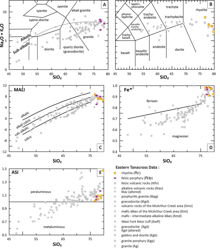
the total alkali (Na2O +K2O) versus silica (SiO2) Extensive and voluminous mid-Cretaceous felsic
diagram (TAS) for intrusive and volcanic rocks (figs. volcanic rocks in the map area prompted Bacon and
2A and B). The plutonic rocks exhibit a range of others (1990) to interpret these rocks as intra-cal-
mafic to felsic compositions. Similarly, the volcanic dera and near-caldera deposits and propose possible
rocks have a broad compositional range from mafic caldera locations. Late Cretaceous igneous activity
to silicic (SiO2 from 53 to 79 weight percent). A immediately north of the map area at the Taurus
supplemental spreadsheet that relates map units to porphyry prospect has been investigated in detail
samples from the geochemical report used for this by Lerich (1995), Harrington (2010), Kreiner and
interpretation can be downloaded from https:// others (2019), and the DGGS Mineral Resources
doi.org/10.14509/30739. See Wypych and others section (Wypych and others, 2021; Twelker and
(2019; https://dggs.alaska.gov/pubs/id/30267) for Newberry, 2021). DGGS investigations include
full documentation of the sample collection, prepa- geochemical and age characterization of the Taurus
ration, and analytical methods. granodiorite and quartz-feldspar porphyry, the Pika
1
Alaska Division of Geological & Geophysical Surveys, 3354 College Rd., Fairbanks, Alaska 99709-3707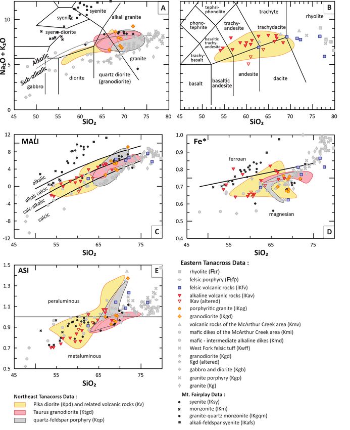
64 Report of Investigation 2021-5E
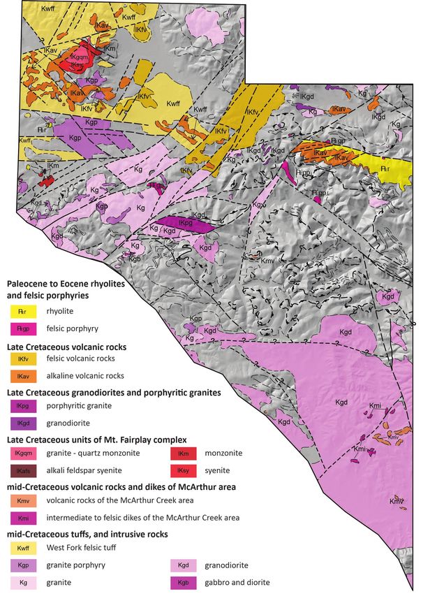
Figure 1. Geographic distribution of igneous units in the Ladue River-Mount Fairplay area (Twelker and others, 2021,
sheet 1). Thin dotted, dashed, and continuous fine lines signify unit contacts; thicker dotted, dashed, and continuous
lines represent faults.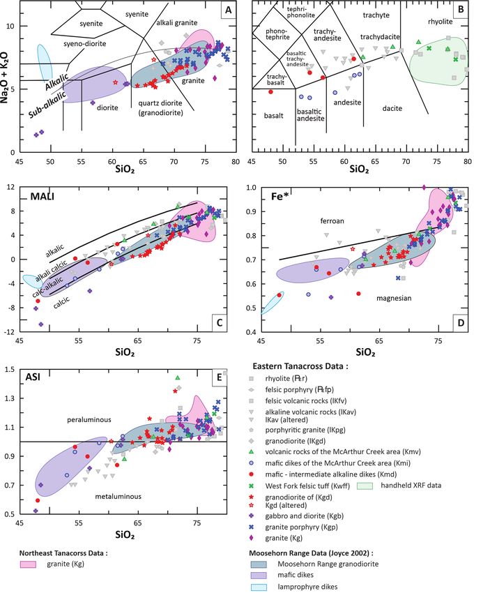
Chapter E: Geochemistry of the Igneous Rocks in the Ladue River-Mount Fairplay area                                      65

Figure 2. Classification diagrams for Paleogene igneous rocks from the Ladue River-Mount Fairplay area. A. Total alkali
versus silica diagram with fields (TAS, labeled after Wilson, 1989) showing the compositional range of the plutonic rocks.
B. TAS with fields (after LeBas and others, 1986) showing the compositional range of the volcanic rocks and dikes.
C. Modified alkali-lime index (MALI = Na2O + K2O - CaO; Frost and others, 2001). D. Fe*= (FeOtot ) / (FeOtot + MgO); Frost and
others, 2001). E. Aluminum saturation index diagram (ASI = Al / (Ca-1.67P+Na+K); Frost and others, 2001). Oxide data have
been normalized to 100-percent anhydrous.
66 Report of Investigation 2021-5E
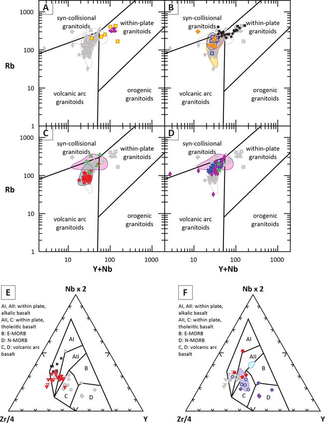
diorite, and other volcanic rocks (Wypych and in the within-plate granitoids field of Pearce and
others, 2021). The Paleogene felsic igneous rocks are others (1984; fig. 4A). The high Y concentration
part of a bimodal, extension-related igneous prov- was easily detectible using a handheld XRF analyzer
ince mapped in the region (for example, Newberry in the field office, thus allowing immediate recog-
and others, 1996; Werdon and others, 2001). Here, nition of the unit. Figures 3A, 3C, 3E, and 3F illus-
we build on the findings of previous researchers trate the handheld XRF data in comparison to the
and provide modern, whole-rock geochemical data ICP-MS-derived trace-element geochemical data.
for the samples in the map area, as well as regional
LATE CRETACEOUS IGNEOUS
comparisons and tectonic interpretations.
ROCKS
PALEOGENE RHYOLITE AND Late Cretaceous igneous rocks in the map
FELSIC PORPHYRY area are grouped into: volcanic rocks (felsic [lKfv]
The youngest igneous rocks in the map area and alkaline [lKav]); granodiorite to granite (lKgd)
are felsic porphyries (:fp) and related rhyolites and porphyritic granite (lKpg); and, intrusive
(:r). The porphyries are mainly present as small rocks of Mount Fairplay complex (granite-quartz
plugs and dikes concentrated in the central map monzonite [lKgqm]; alkali-feldspar syenite [lKafs];
area (Twelker and others, 2021), whereas the rhyo- monzonite [lKm]; and, syenite [lKsy]).
lite unit consists of rhyolite and felsic tuffs outcrop- Felsic volcanic rocks are concentrated along
ping in a single volcanic field north of Ladue River. the East Fork of the Dennison Fork of the Fortymile
The Paleogene units are highly siliceous, with SiO2 river and include felsic tuffs, dacites, and rhyolites.
greater than 76 weight percent (fig. 2B), and are The porphyritic granite is a fault-bound unit located
calc-alkalic to calcic, ferroan, and peraluminous west of the Oreo Mountain porphyry copper-mo-
(figs. 2C–E). The trace-element composition of the lybdenum prospect in the Tanacross B-2 Quad-
Paleogene units is distinctive and easily differenti- rangle, 13 km east of Ladue River, and is charac-
ated from older igneous rocks in the region (figs. terized by large potassium feldspar phenocrysts in a
3A–F). With the exception of one outlier with medium-grained groundmass consisting of quartz,
over 600 parts per million (ppm) strontium (Sr) feldspar, hornblende, and biotite. Unit lKgd dikes
and 300 ppm barium (Ba), the units have low Sr and stocks outcrop in the area between the Taurus
concentrations (averaging 20 ppm, fig. 3A), low and Oreo prospects and can be compared composi-
europium (Eu, 0.04 to 0.25 ppm, fig. 3D), and low tionally to quartz-feldspar porphyry (Kqp), Taurus
Ba (15 to 85 ppm); all of these indicate fraction- granodiorite (Ktgd), and Pika diorite (Kpd) in the
ation of plagioclase and are characteristic of highly Northeast Tanacross geologic map area (figs. 4B–6,
evolved magmas. The high field-strength elements Wypych and others, 2021). The Late Cretaceous
(HFSE) are elevated, with thorium (Th) up to 40.7 felsic rocks exhibit high SiO2 concentrations, from
ppm, yttrium (Y) averaging around 40 ppm and up 66.0 to 77.6 weight percent, with one exception
to 103 ppm, and zirconium (Zr) averaging around of 62.5 weight percent (figs. 5A and B). They are
200 ppm (figs. 3C, E, and F). Likewise, heavy calc-alkalic, magnesian, and largely metaluminous
rare earth elements (REE) are elevated: ytterbium (figs. 5C–E), except for the peraluminous volcanic
(Yb) reaches near 10 ppm, lutetium (Lu) over 1.3 rocks (lKfv) (fig. 5E). Unit lKfv is highly siliceous;
ppm, and hafnium (Hf ) nearing 10 ppm, whereas we have observed only a couple of such high-silica
light REE are comparable to other units in the rhyolites in the Northeast Tanacross map area and
region (fig. 3B). All these trace-element character- there we assigned them to volcanic rocks unit Kv
istics indicate an extension-related magma source, (Wypych and others, 2021). The trace-element
which is further highlighted by niobium (Nb) plus composition of lKfv generally overlaps that of the
Y versus rubidium (Rb) concentrations plotting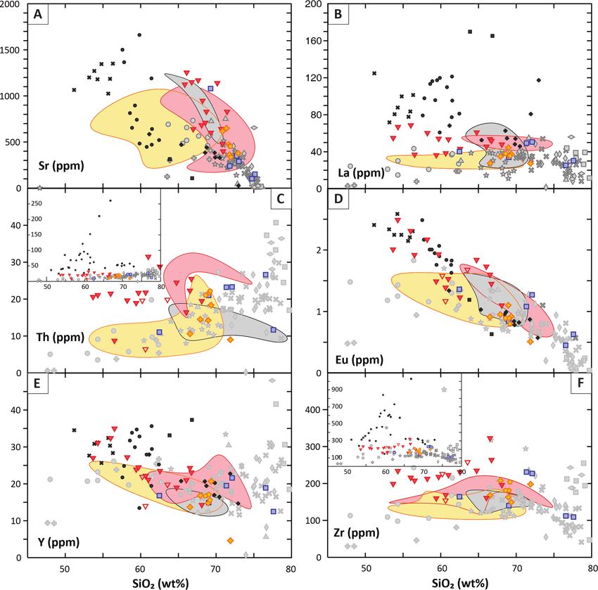
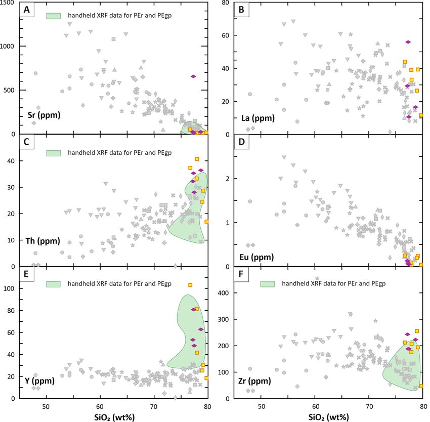
Chapter E: Geochemistry of the Igneous Rocks in the Ladue River-Mount Fairplay area                                     67

other felsic samples (figs. 6A–F) and is comparable             map area (figs. 6A–F). In terms of major-element
to that of the most siliceous Kv samples (Wypych,               composition, unit lKgd follows the Ktgd unit of the
2021). Late Cretaceous porphyritic granite (lKpg)               Northeast Tanacross map area (Wypych, 2021).
is characterized by its elevated magnesian character            However, the trace element composition of unit
compared to other igneous rocks of similar silica               lKgd suggests a better correlation to the Pika diorite
composition in the map area (fig. 5D). Similar                  (Kpd) unit in the Northeast Tanacross map area
to lKav, unit lKpg has trace-element characteris-               (figs. 6A–F). This unit has lower lanthanum (La),
tics similar to Kv from the Northeast Tanacross                 Th, and Eu than most Ktgd (figs. 6B–D), and lower

Figure 3. Bivariate plots of SiO2 (wt.%) vs. selected trace element abundances (ppm). Symbols and colors as in figure 2, pale
green polygons represent major- and trace-element data collected using hand-held XRF for Paleogene rocks.
68       Report of Investigation 2021-5E

Figure 4. Tectonic classification diagrams for felsic igneous rocks from the Ladue River-Mount Fairplay area after Pearce
and others (1984) for: (A) Paleogene rocks; (B) Late Cretaceous granitoids; (C) mid-Cretaceous volcanic rocks of McArthur
Creek area (Kmv) area and granodiorite (Kgd); and (D) mid-Cretaceous West Fork felsic tuff (Kwff), granite porphyry (Kgp)
and granite (Kg); (E) high field-strength element, tectonic discrimination ternary diagram for Late Cretaceous mafic rocks (af-
ter Meschede, 1986); and (F) high field-strength element, tectonic discrimination ternary diagram for mid-Cretaceous mafic
rocks (after Meschede, 1986).
Chapter E: Geochemistry of the Igneous Rocks in the Ladue River-Mount Fairplay area                                     69

Figure 5. Classification diagrams for Late Cretaceous igneous rocks from the Ladue River-Mount Fairplay area. A. TAS show-
ing the compositional range of the plutonic rocks. B. TAS showing the compositional range of the volcanic rocks and dikes.
C. MALI= Na2O + K2O - CaO; Frost and others (2001). D. Fe**= (FeOtot ) / (FeOtot + MgO); Frost and others (2001). E. ASI
ASI = Al / (Ca-1.67P+Na+K); Frost and others (2001). Oxide data have been normalized to 100-percent anhydrous. Open
symbols signify samples described (in the field by the collector) as “altered;” closed symbols represent samples described as
“unaltered” or “fresh.”
70      Report of Investigation 2021-5E

Sr than Kqp (fig. 6A). All the above late Cretaceous       Zr (figs. 6A, C, and F; Wypych and others, 2019).
intrusive units, as well as the felsic volcanic rocks,     The granite-quartz monzonite, on the other hand,
have Nb plus Y and Rb concentrations character-            follow the late Cretaceous unit trends (figs. 6A–E)
istic of volcanic-arc granitoids (fig. 4B).                apart from slightly elevated Zr (fig. 6F). The syenites
                                                           are characterized by largely within-plate chemical
      Alkaline volcanic rocks (lKav) are basaltic
                                                           composition, and the granite-quartz monzonite is
trachyandesite to trachydacite lava flows and tuffs,
                                                           of volcanic-arc with some syn-collisional affinity
with SiO2 composition between 51 and 66 weight
                                                           samples present (figs. 4B and E).
percent, and total alkali between 5 and 8 weight
percent. This group is mainly alkali-calcic, magne-        MID-CRETACEOUS IGNEOUS ROCKS
sian, and metaluminous, however, a few samples                   The mid-Cretaceous igneous rocks in the
display calc-alkalic, ferroan, and peraluminous            Eastern Tanacross geologic map area are extensive
compositions (figs. 5B–E). This group generally            and include volcanic rocks and dikes of the McAr-
follows major element composition of the volcanic          thur Creek area (Kmv and Kmi), mafic to inter-
rocks observed in the Northeast Tanacross map area         mediate alkaline dikes (Kmd), the West Fork Tuff
(Kv, figs. 5B–F) but trace elements are distinct. The      (Kwff), granodiorite and gabbro and diorite (Kgd
elevated La, Th, and Zr (figs. 6B, C, and F) distin-       and Kgb), and granite porphyry and granite (Kgp
guishes this unit from any Late Cretaceous unit            and Kg, fig.1). The units observed in the map area
mapped in the Ladue River-Mount Fairplay map               are much more diverse in terms of textures, ages, and
area. This unit is unique as it clearly has within-plate   geochemical composition than the mid-Cretaceous
tectonic affiliation, as highlighted on the Zr-Y-Nb        rocks observed in our Northeast Tanacross map area
classification triangle for mafic rocks (fig. 4E).         (Kg; Wypych and others, 2021) and range between
       The units of Mount Fairplay complex outcrop         45 and 78 weight percent SiO2 (figs. 7A and B). Like
about 85 km north from Alaska Highway junction             Kmi, the alkaline dikes (Kmd) intrude the large gran-
along the Taylor Highway, and are often porphy-            odiorite (Kgd) batholith in the southern quadrant
ritic, with large feldspar phenocrysts in a medium-        of the map area. Rhyolite to dacite West Fork tuffs
to-coarse-grained matrix. They are largely mafic,          and flows (Kwff) cover a very large area in the north-
ranging from 50 to 67 weight percent SiO2, with            west quadrant of the map area, and granite porphyry
the exception of granite-quartz monzonite (unit            (Kgp) and granite (Kg) are mainly observed just
lKgqm), which has 69 to 76 weight percent SiO2,            south of Kwff. Because of extensive weathering and
and generally forms a different trend than the rest        alteration in the tuffaceous Kwff unit, only two fresh
of complex, resembling more closely other Late             samples were available to analyze by commercial lab
Cretaceous units of the region (figs. 5A–E). Gran-         whole-rock methods.
ite-quartz monzonite and part of monzonite (lKm)                 The McArthur Creek volcanic rocks (Kmv)
unit are alkali-calcic and magnesian, whereas the          are characterized by alkali-calcic, ferroan, and
syenite and alkali-feldspar syenite (lKsy and lKafs)       peraluminous major-element compositions (figs.
are strongly alkalic and ferroan (figs. 5C and D),         7C–F). Other ferroan and peraluminous units in
all the Mount Fairplay units are metaluminous,             the region, such as granite (Kg), granite porphyry
except for a few samples from the granite-quartz           (Kgp), and West Fork tuffs and flows (Kwff), are
monzonite (fig. 5E). The high-alkali units also have       generally calc-alkalic. The mafic dikes (Kmi) are
distinctive trace element patterns from all other          calcic to calc-alkalic, magnesian, and metalumi-
igneous units, particularly visible in the Sr, La, Th,     nous and are less alkalic than the alkaline dikes
and Zr concentrations (figs. 6A–C and F). Those            (Kmd, figs. 7C–E). The most calcic groups, Kgd
elements are elevated in the units, with Sr reaching       and Kgb, are magnesian. Unit Kgd is peraluminous
1,655 ppm, 261 ppm of Th, and 1,030 ppm of                 and closely resembles the Moosehorn Range gran-
Chapter E: Geochemistry of the Igneous Rocks in the Ladue River-Mount Fairplay area 71
odiorite (unit MRG; Joyce, 2002), and gabbro and with SiO2 below 70 weight percent have higher
diorite (Kgb) are metaluminous and similar to the Sr concentration—up to 750 ppm—than other
mafic dikes (Kmi, figs. 7C–E). mid-Cretaceous samples, whereas the higher silica
samples have a low Sr concentration—38 ppm (fig.
Trace-element compositions of the mid-Creta-
8A). The mafic dikes of Kmi have cohesive trace-el-
ceous units vary, but the correlation of some of the
ement compositions (figs. 8A–F) comparable to
elements with silica suggest fractionation trends,
other mid-Cretaceous mafic igneous rocks, but
such as plagioclase fractionation highlighted by the
lower than the Moosehorn Range mafic dikes of
silica versus Sr plot (fig. 8A). Unit Kmv is charac-
Joyce (2002), highlighted by La, Eu, and Y plots
terized by bimodal Sr composition: the samples
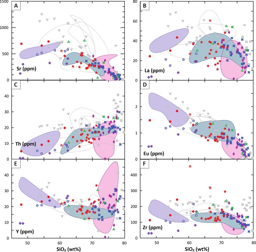
Figure 6. Bivariate plots of SiO2 (wt.%) vs. selected trace element abundances (ppm). Symbols and colors as in figure 5;
insets in C and F show an expanded y-axis scale to accommodate Th- and Zr-rich Mount Fairplay samples.72 Report of Investigation 2021-5E Figure 7. Classification diagrams for mid-Cretaceous igneous rocks from the Ladue River-Mount Fairplay area. A. TAS show- ing the compositional range of the plutonic rocks. B. TAS showing the compositional range of the volcanic rocks and dikes. C. MALI= Na2O + K2O - CaO; Frost and others (2001). D. Fe**= (FeOtot ) / (FeOtot + MgO); Frost and others (2001). E. ASI ASI = Al / (Ca-1.67P+Na+K); Frost and others (2001). Oxide data have been normalized to 100-percent anhydrous. Open symbols signify samples described (in the field by the collector) as “altered;” closed symbols represent samples described as “unaltered” or “fresh.”
Chapter E: Geochemistry of the Igneous Rocks in the Ladue River-Mount Fairplay area                        73

(figs. 8 B,D, and E). Unit Kmd can be differenti-         the Paleogene units, have distinctive “within-plate”
ated from the McArthur Creek mafic dikes (Kmi)            signatures (figs. 4A and E). In mid-Cretaceous
by elevated Sr, La, Th, Eu, and Zr (figs. 8A–D and        samples, this signature is observed in unit Kmd (fig.
F), and other light rare earth elements (Wypych and       4F), whereas siliceous samples from the McAr-
others, 2019). Unit Kgd is generally on trend with        thur Creek area have syn-collisional trace element
the MRG samples (figs. 8A–F) but differs from             compositions (fig. 4C). The change in geochem-
most of the other mid-Cretaceous igneous rocks.           ical signature between Cretaceous and Paleogene
This is particularly well illustrated by SiO2 versus      igneous rocks marks a change in the tectonic
Zr plot (fig. 8F), where the granodiorite forms a         regime. Mid-Cretaceous extensional faulting and
separate trend. The gabbros have low trace element        a ca. 115 Ma northeast-dipping subduction zone
concentrations, except Y and Eu in a couple of            (Hansen and Dusel-Bacon, 1998; Dusel-Bacon
more evolved, higher silica samples (figs. 8D and         and others, 2002, 2015) are responsible for the
E). Trace element composition of Kpg and Kg are in        within-plate and volcanic-arc signatures observed
agreement with the Kg unit of the Northeast Tana-         in the oldest igneous rocks of eastern Tanacross
cross map area (Wypych, 2021), but separate frac-         (Allan and others, 2013). The Late Cretaceous
tionation trends on Zr plots (fig. 8F) suggest differ-    magmatic pulse has a similar mixture of volca-
ences in zircon fractionation between the two units.      nic-arc and within-plate trace-element composi-
                                                          tions. The Paleogene rocks display within-plate
      The diversity in trace-element composition in
                                                          trace-element signatures almost exclusively and
the mid-Cretaceous rocks is reflected in the tectonic
                                                          are highly evolved. In other parts of eastern inte-
classification diagrams (figs. 4C, D, and F). The
                                                          rior Alaska, this magmatism is bimodal (Bacon and
majority of the units are characterized by volca-
                                                          others, 1990; Foster and others, 1994; Newberry
nic-arc granitoid signatures, however, part of the
                                                          and others, 1996). The presence of alkaline Late
Kmv group and two Kg samples have syn-collisional
                                                          Cretaceous rocks and Paleogene bimodal volcanism
signatures; a sample from Kgb plots in the E-MORB
                                                          in the region suggests onset of regional extension in
field, and Kmd has a within-plate affinity (figs. 4C
                                                          the Late Cretaceous and continuing into the Paleo-
and F). In the Northeast Tanacross map area, we
                                                          gene (Dusel-Bacon and others, 2009, 2015).
observed syn-collisional as well as within-plate gran-
itoids within the Kg group (Wypych, 2021).                ACKNOWLEDGMENTS
CONCLUSIONS                                                     The author would like to thank the DGGS
                                                          Mineral Resources section field geologists and other
      The unmetamorphosed magmatic units in the
                                                          DGGS staff who contributed to this data collection,
Ladue River-Mount Fairplay map area span from
                                                          scientific discussions, and other support.
mid-Cretaceous to Paleogene time. Most of the
Cretaceous igneous activity is volcanic-arc related            This project was jointly funded by the State
(figs. 4B–D). The magnesian signature of most             of Alaska and the U.S. Geological Survey’s Earth
samples supports magma genesis under oxidized             Mapping Resources Initiative (Earth MRI) through
conditions (Frost and Frost, 2008). A few ferroan         cooperative agreement G19AC00262. The views
exceptions are the high-silica Paleogene rhyolites        and conclusions contained in this document are
and porphyries (:r, :fp) and mid-Cretaceous               those of the authors and should not be interpreted
syenite (lKsy), alkali-feldspar syenite (lKafs), and      as representing the opinions or policies of the
granite and granitic porphyry (Kg and Kgp units),         U.S. Geological Survey. Mention of trade names
as well as some samples from unit lKav. Late Creta-       or commercial products does not constitute their
ceous syenite (lKsy), alkali-feldspar syenite (lKafs,),   endorsement by the U.S. Geological Survey.
and alkali volcanic rocks form unit lKav, as well as
74 Report of Investigation 2021-5E
Figure 8. Bivariate plots of SiO2 (wt.%) vs selected trace element abundances (ppm). Symbols and colors as in figure 7.
REFERENCES J.F.H., Tectonics, Metallogeny, and Discovery:
Allan, M.M., Mortensen, J.K., Hart, C.R, Bai- The North American Cordillera and Similar Ac-
ley, L.A., Sanchez, M.G., Ciolkiewicz, Wiltold, cretionary Settings: Society of Economic Geolo-
McKenzie, G.G., and Creaser, R.A., 2013, Mag- gists, Special Publication 17, p. 111–168.
matic and metallogenic framework of west-cen- Bacon, C.R., Foster, H.L., and Smith, J.G., 1990,
tral Yukon and eastern Alaska, in Colpron, Mau- Rhyolitic calderas of the Yukon-Tanana terrane,
rice, Bissig, Thomas, Rusk, B.G., and Thompson, east- central Alaska—Volcanic remnants of a mid-
Cretaceous magmatic arc: Journal of GeophysicalChapter E: Geochemistry of the Igneous Rocks in the Ladue River-Mount Fairplay area 75 Research, v. 95, no. B13, p. 21,451–21,461. ka—A record of late Paleozoic to Mesozoic crustal Dusel-Bacon, Cynthia, Aleinikoff, J.N., Day, W.C., assembly: Geological Society of America Bulletin and Mortensen, J.K., 2015, Mesozoic magma- v. 110, no. 2, p. 211–230. tism and timing of epigenetic Pb-Zn-Ag miner- Harrington, Edward, 2010, Technical report on the alization in the western Fortymile mining district, Taurus property, Fairbanks Recording District, east-central Alaska: Zircon U-Pb geochronology, Alaska, U.S.A.: Unpublished NI43-101 report whole-rock geochemistry, and Pb isotopes: Geo- for Senator Minerals Inc., 133 p. sphere, v. 11, no. 3, p. 786–822. Joyce, N.L., 2002, Geologic setting, nature, and Dusel-Bacon, Cynthia, Lanphere, M.A., Sharp, structural evolution of intrusion-hosted Au-bear- W.D., Layer, P.W., and Hansen, V.L., 2002, ing quartz veins at the Longline occurrence, Mesozoic thermal history and timing of structural Moosehorn Range area, west-central Yukon Ter- events for the Yukon-Tanana Upland, east- ritory: Unpublished Master’s thesis, University of central Alaska: 40Ar/39Ar data from metamorphic British Columbia, Vancouver, Canada. 199 p. and plutonic rocks: Canadian Journal of Earth Kreiner, D.C., Jones III, J.V., Todd, Erin, Holm-De- Sciences, v. 39, no. 6, p. 1,013–1,051. http://doi. noma, Chris, Caine, J.S., Benowitz, J.A., 2019, org/10.1139/e02-018 Links between tectonics, magmatism, and min- Dusel-Bacon, Cynthia, Slack, J.F., Aleinikoff, J.N., eralization in the formation of Late Cretaceous and Mortensen, J.K., 2009, Mesozoic magmatism porphyry systems in the Yukon-Tanana upland, and base-metal mineralization in the Fortymile eastern Alaska, USA: Proceedings of the 15th bi- mining district, eastern Alaska—initial results of ennial meeting for geology applied to mineral de- petrographic, geochemical, and isotopic studies posits, p. 939–942. in the Mount Veta area: Studies by the U.S. Geo- LeBas, M.J., LeMaitre, R.W., Streckeisen, Albert, logical Survey in Alaska, 2007: U.S. Geological and Zanettin, Bruno, 1986, A Chemical Clas- Survey Professional Paper 1760-A, p. 1–42. sification of Volcanic Rocks Based on the Total Foster, H.L., 1967, Geology of the Mount Fairplay Alkali-Silica Diagram: Journal of Petrology, v. 23, area, Alaska: U.S. Geological Survey Bulletin no. 3, p. 745–750. 1241-B, p. B1–B18, 1 sheet, scale 1:63,360. Lerich, P.D., 1995, Taurus copper-molybdenum Foster, H.L., 1970, Reconnaissance geologic map porphyry deposit, east-central Alaska, in Schro- of the Tanacross Quadrangle, Alaska: U.S. eter, T.G., ed., Porphyry Deposits of the North- Geological Survey Miscellaneous Geologic western Cordillera of North America: Canadian Investigations Map 593, 1 sheet, scale 1:250,000. Institute of Mining Metallurgy and Petroleum Foster, H.L., Keith, T.E.C., and Menzie, W.D., Special Volume 46, p. 451–457. 1994, Geology of the Yukon-Tanana area of Meschede, Martin, 1986, A method of discrimina- east-central Alaska, in Plafker, George, and Berg, tion between different types of mid-ocean ridge H.C., eds., The Geology of Alaska, v. G-1 of The basalts and continental tholeiites with the Nb-Zr-Y Geology of North America: Boulder, Colorado, diagram: Chemical Geology, v. 56, p. 207–218. Geological Society of America, p. 205–240. Newberry, R.J., 2020, The Mount Fairplay igneous Frost, B.R., Barnes, C.G., Collins, W.J., Arculus, complex: Alaska Division of Geological & Geo- R.J., Ellis, D.J., and Frost, C.D., 2001, A geo- physical Surveys Preliminary Interpretive Report chemical classification for granitic rocks: Journal 2020-1, 32 p. https://doi.org/10.14509/30463 of Petrology, v. 42, no. 11, p. 2,033–2,048. Newberry, R.J., Bundtzen, T.K., Clautice, K.H., Frost, B.R., and Frost, C.D., 2008, A Geochemical Combellick, R.A., Douglas, Tom, Laird, G.M., Classification for Feldspathic Igneous Rocks: Jour- Liss, S.A., Pinney, D.S., Reifenstuhl, R.R., and nal of Petrology, v. 49, no. 11, p. 1,955–1,969. Solie, D.N., 1996, Preliminary geologic map Hansen, V.L., and Dusel-Bacon, Cynthia, 1998, of the Fairbanks mining district, Alaska: Alaska Structural and kinematic evolution of the Yu- Division of Geological & Geophysical Surveys kon-Tanana Upland tectonites, east-central Alas- Public Data File 96-16, 17 p., 2 sheets, scale
76      Report of Investigation 2021-5E

  1:63,360. https://doi.org/10.14509/1740               the Eagle A-2 Quadrangle, Fortymile mining
Pearce, J.A., Harris, N.B., and Tindle, A.G., 1984,     district, Alaska: Alaska Division of Geological
  Trace element discrimination diagrams for the         & Geophysical Surveys Preliminary Interpretive
  tectonic interpretation of granitic rocks: Journal    Report 2001-3A, 1 sheet, scale 1:63,360, v. 1.0.1.
  of Geophysical Research, v. 103, p. 7,171–7,186.      https://doi.org/10.14509/2669
Szumigala, D.J., Newberry, R.J., Werdon, M.B.,         Wilson, Marjorie, 1989, Igneous petrogenesis A
  Athey, J.E., Stevens, D.S.P., Flynn, R.L., Clau-      Global Tectonic Approach: Unwin Hyman,
  tice, K.H., and Craw, P.A., 2002, Geologic map        London, 416 p.
  of the Eagle A-1 Quadrangle, Fortymile mining        Wypych, Alicja, Twelker, Evan, Naibert, T.J.,
  district: Alaska Division of Geological & Geo-        Athey, J.E., Newberry, R.J., Lopez, J.A., Regan,
  physical Surveys Preliminary Interpretive Report      S.P., Sicard, K.R., Wildland, A.D., and Wyatt,
  2002-1A, 1 sheet, scale 1:63,360. https://doi.        W.C., 2019, Major-oxide and trace-element
  org/10.14509/2863                                     geochemical data from rocks collected in 2019 for
Twelker, Evan, Newberry, R.J., Wypych, Alicja,          the Eastern Tanacross project, Tanacross and part
  Naibert, T.J., Wildland, A.D., Sicard, K.R., Re-      of Nabesna quadrangles, Alaska: Alaska Division
  gan, S.P., Athey, J.E., Wyatt, W.C., and Lopez,       of Geological & Geophysical Surveys Raw Data
  J.A., 2021, Bedrock geologic map of the La-           File 2019-8, 3 p. https://doi.org/10.14509/30267
  due River-Mount Fairplay area, Tanacross and         Wypych, Alicja, Hubbard, T.D., Naibert, T.J., Athey,
  Nabesna quadrangles, Alaska, in Twelker, Evan,        J.E., Newberry, R.J., Sicard, K.R., Twelker, Evan,
  ed., Geologic investigation of the Ladue Riv-         Werdon, M.B., Willingham, A.L., Wyatt, W.C.,
  er-Mount Fairplay area, eastern Alaska: Alaska        and Lockett, A.C., 2021, Northeast Tanacross
  Division of Geological & Geophysical Surveys          geologic map and map units and descriptions, in
  Report of Investigation 2021-5A. https://doi.         Wypych, Alicja, ed., Northeast Tanacross geologic
  org/10.14509/30735                                    mapping project, Alaska: Alaska Division of Geo-
Twelker, Evan, and Newberry, R.J., 2021,                logical & Geophysical Surveys Report of Investi-
  Observations on the economic geology of the           gation 2020-9B. https://doi.org/10.14509/30539
  northeast Tanacross map area, in Wypych, Alicja,     Wypych, Alicja, 2021, Geochemical interpreta-
  ed., Northeast Tanacross geologic mapping             tion of samples of igneous rocks from northeast
  project, Alaska: Alaska Division of Geological        Tanacross, in Wypych, Alicja, Northeast Tana-
  & Geophysical Surveys Report of Investigation         cross geologic mapping project, Alaska: Alaska
  2020-9F. https://doi.org/10.14509/30557               Division of Geological & Geophysical Surveys
Werdon, M.B., Newberry, R.J., Szumigala, D.J.,          Report of Investigation 2020-9E. https://doi.
  and Pinney, D.S., 2001, Geologic map of               org/10.14509/30542
You can also read