GSS Geography Policy March 2015 - UK Statistics Authority
←
→
Page content transcription
If your browser does not render page correctly, please read the page content below
GSS Geography Policy March 2015

Document control

Version: 2

Date: March 2015

Author: ONS Geography contact: ons.geography@ons.gsi.gov.uk

Status: Policy version 2 published by the GSS, March 2015

History:
                 Version 1.0 Geography Policy for National Statistics approved by GSS Regional and
 July 2010
                 Geography Committee (RGC)

                 Version 1.1 Geography Policy for National Statistics reviewed and ratified by GSS
 May 2012
                 Statistical Standards and Policy Committee (SPSC)

                 Version 2.0 to GSS Regional and Geography Committee following review and
 July 2014
                 consultation after 2011 Census. Rebranded as the GSS Geography Policy.

                 Version 2.1 GSS Geography Policy to GSS SPSC and National Statistician’s Good
 October 2014
                 Practice Team for sign-off

 March 2015      Version 2.3 published as Version 2 (March 2015)

GSS Geography Policy    v2                       March 2015                                   Page 2
GSS GEOGRAPHY POLICY
Introduction
Accurate geographic information is essential for statistics to:
• locate and reference a statistical event
• provide the geographical framework to sample, collect, link and process survey and
administrative data
• analyse and present statistics
• select and access information for a geographical area or place
The Code of Practice for Official Statistics states that “common geographic referencing and coding
standards” should be adopted to promote comparability in official statistics. 1
This GSS Geography Policy sets out the principles of those standards. It provides best practice
guidance on the geographic reference data to use, and how to use it so that official statistics are
geographically comparable, consistent and fit for purpose.
Background
The Geography Policy for Neighbourhood Statistics (NeSS) was published in 2004. This formed the
basis of the Geography Policy for National Statistics that was formally agreed and mandated for use
across the GSS by the GSS Regional and Geography Committee (RGC) in July 2010. The policy was
then ratified by the GSS Statistical Policy and Standards Committee (SPSC) in February 2012.
The policy was reviewed following the 2011 Census and rebranded as the GSS Geography Policy.
This version of the policy was agreed by the GSS RGC in July 2014 and ratified by the GSS SPSC in
November 2014.
Policy objectives
The policy provides best practice guidance for producers of statistics to:
• geographically reference statistical events accurately, consistently and at the lowest
possible level
• maximise the comparability of their statistics with other official statistics
• minimise the impact of changing area boundaries on official statistics outputs
• standardise how geography and associated information is defined, used and presented in
statistics
• meet legal requirements to safeguard the confidentiality of statistics
Code of Practice for Official Statistics, Edition 1.0 2009, Principle 4 Practice 6
1
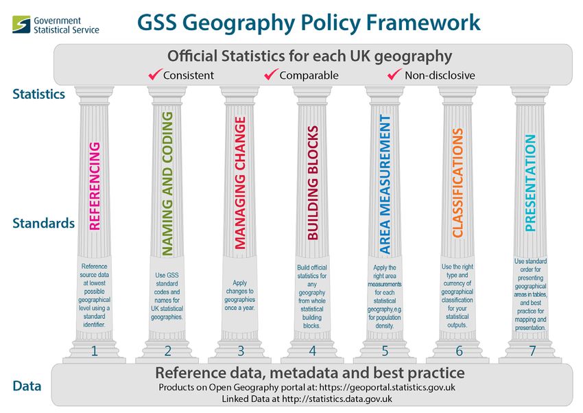
GSS Geography Policy v2 March 2015 Page 3Governance of this policy The GSS Geography Policy is owned by ONS Geography on behalf of the GSS. The policy is approved for the GSS by the GSS Regional and Geography Committee (RGC) before final ratification by the GSS Standards and Statistical Policy Committee (SPSC). The policy is mandated for the production of all official statistics across the GSS. Compliance with the policy All producers of official statistics should comply with the policy, as part of the Code of Practice for Official Statistics. Each GSS department has a Geography Champion, appointed by their Head of Profession, responsible for implementing the policy in their own statistical production processes. Exceptions The Code of Practice for Official Statistics states that “reasons for any deviations from standard models should be made publicly available”. Producers of official statistics that do not comply with this policy should make the deviation and reasons for it clear with the published statistics. GSS Framework for Geography – the Seven Pillars of best practice Figure 1 shows how the GSS Geography Policy Framework harmonises the use of geography and geographic data across the GSS. This policy sets out each of the seven pillars of best practice for using geography in statistical processing. The definitive geographic reference data to support the pillars are available as downloadable products from the Open Geography portal at https://geoportal.statistics.gov.uk. These are also available in machine-readable format at the ONS Geography Linked Data portal at http://statistics.data.gov.uk/. GSS Geography Policy v2 March 2015 Page 4
PILLAR 1 REFERENCING

      Reference source data at lowest possible geographical level
                     using a standard identifier

1.1 Principles: Pillar 1 Referencing
 1.1.1 Reference source data at the lowest level collected
       Source data relating to individuals, households or businesses should be recorded at address
       level. Where addresses are not collected, postcodes should be used.
 1.1.2 Reference source data with a national grid reference
       Matching the address or postcode allows a grid reference to be allocated to the source
       data. This ties the statistical event to a point on the ground.
       Where there is no address or postcode (for example a crime taking place in a car park), a
       grid reference should be attached.
       Grid references should be stored at a minimum accuracy of 1 metre resolution.
 1.1.3 Reference source data to a unique identifier – for addresses this is the UPRN
       When the data being referenced relates directly to a real world object (for example a
       building or section of street), they should be linked to these objects by its identifier. For
       addresses the identifier is the Unique Property Reference Number (UPRN), which uniquely
       identifies each address on the Great Britain’s national address gazetteer, AddressBase.
 1.1.4 Reference source data to a statistical building block
       Each record should be referenced to a statistical building block. This will enable output
       statistics to be produced in a standard way, in line with the policy. More information on
       building blocks is given under policy pillar 4 (Building blocks).
 1.1.5 Reference source data to output geographies by best-fitting them from statistical building
       blocks
       Where each record is referenced to output geographies for which statistics are to be
       produced, it should be by
       1. referencing to a small area building block (as at 1.1.4), then
       2. allocating and referencing the record to the output geography that its small area
          building block best fits to.
       The method of best-fitting is explained at policy pillar 4 (Building blocks).
       Best-fitting ensures records are consistently referenced to the level of the small area
       building block. Statistics produced from these records can be compared with other official
       statistics referenced in the same way.

GSS Geography Policy    v2                         March 2015                                 Page 5
1.2 Data/tools to support Pillar 1 Referencing
1.2.1 To reference at address level:
1. Match to the definitive national set of addresses
GB addresses are available from the national address gazetteer AddressBase. This is
available free to the GSS under the Public Sector Mapping Agreement.
Scotland addresses are available from the One Scotland Gazetteer. This is available to the
Scottish GSS members under the One Scotland Mapping Agreement (OSMA).
Northern Ireland addresses are available from the Pointer product. This is available free to
NI government departments under the Northern Ireland Mapping Agreement .
2. Capture the unique address key, the UPRN
Use address matching software to capture the UPRN of the address. Each address in the
national address gazetteer AddressBase has a unique key, called a UPRN (Unique Property
Reference Number).
3. Allocate the address to its statistical building block
Use the data product that links each UPRN to its statistical building block (Output Areas in
England, Wales and Scotland), available from the Open Geography portal, to attach to each
source data record.
1.2.2 To reference at postcode level:
All postcodes have a centroid, represented by the mean grid reference of all addresses in
the postcode, snapped to the nearest address. The postcodes are allocated to any
geography by plotting their centroids into the geography’s digital boundaries. This is known
as the Gridlink method, used by the core producers of postcode products in the UK. This
ensures all postcode products have consistent postcode allocations.
For UK Postcodes
National Statistics Postcode Lookup (NSPL)
1. The NSPL allocates postcodes to higher geographies on the basis of the postcode’s
Output Area (Small Areas in Northern Ireland). All postcodes in an Output Area are
allocated to the same higher geography using the best-fit method explained at policy
pillar 4 (Building blocks). Use the NSPL to reference source data to statistical
geographies. Statistics produced from source data referenced by the NSPL will always be
built from statistical building blocks, in line with this policy.
2. The only output geography on the NSPL to which postcodes are allocated directly, rather
than via their statistical building block, is National Parks. National Parks are largely rural
and tend to be sparsely populated. In exceptional cases, there are large differences
between statistics for National Parks produced by best-fitting from statistical building
blocks, and statistics produced for the same areas where the population is allocated
directly (exact-fit). The policy is therefore to produce official statistics for National Parks
GSS Geography Policy v2 March 2015 Page 6as exact-fit.
ONS Postcode Directory (ONSPD)
3. The ONSPD allocates postcodes directly to a number of output geographies, by plotting
their centroid into digital boundaries. ONSPD allocations are therefore not on the basis
of its Output Area as is the case with the NSPL. In the ONSPD, postcodes that are in the
same Output Area can be allocated to different output geographies in cases where an
Output Area falls across two or more of those output geographies.
4. Use the ONSPD if you need the allocation of postcodes to be more exact - for example
for operational or administrative applications. Do not use the ONSPD for producing
official statistics.
2011 Census enumeration postcodes
5. 2011 Census enumeration postcodes were recorded during the 2011 Census as
containing one or more usual residents. These postcodes were assigned directly to
selected higher geographies, such as civil parishes and wards, on the same basis as the
ONSPD, and not on the basis of the postcode’s Output Area.
6. Use the 2011 Census enumeration postcodes if you need to link to 2011 Census
postcode estimates. These postcodes were also assigned on the basis of their recorded
location at the time of the 2011 Census. Use these postcodes with 2011 Census
estimates of the number of males, females and households for each enumeration
postcode, published in June 2013.
For more detail about the above postcode directories see
Explanation of the differences between the NSPL and ONSPD
Scotland
7. Postcode referencing data for Scottish only postcodes is also available from
http://www.nrscotland.gov.uk/statistics-and-data/geography/nrs-postcode-extract
Northern Ireland
8. Postcode referencing data for Northern Ireland only postcodes is also available from
http://www.nisra.gov.uk/geography/postcode.htm
1.2.3 To reference from statistical building blocks to output geographies
OA and SOA Lookups (England and Wales)
1. Lookups from OAs and SOAs best fitted to a range of output geographies. If you have
statistics for Output Areas and Super Output Areas, use these lookups to aggregate
them to other output geographies.
OA lookup (Scotland)
2. OA lookups to a range of higher geographies are available from NRS at
http://www.nrscotland.gov.uk/statistics-and-data/geography/our-products
GSS Geography Policy v2 March 2015 Page 7OA lookup (Northern Ireland)
3. OA lookups to higher geographies are available from NISRA at
http://www.nisra.gov.uk/archive/geography/11DC_Lookup.xls
1.2.4 To allocate grid-referenced records to output geographies
Digital boundaries
1. Use GIS software to allocate grid-referenced source data into any geography, plotting
them into their digital boundaries.
2. For official statistics outputs, always allocate records to a statistical building block, then
to other geographies that its statistical building block best-fits to. This is explained in
Pillar 4 (Building blocks)
1.3 Benefits: Pillar 1 Referencing
1.3.1 Referencing source data at a low level locates a statistical event more precisely. It provides
the flexibility to build statistics for higher geographies from record level data rather than
from aggregated data.
1.3.2 Grid-referenced source data can be allocated to any geography, using GIS software to plot
the grid references into the geography’s digital boundaries.
1.3.3 Identifiers linked to real world objects (such as the UPRN) make it easier to link and match
records. They also give greater certainty that records match.
1.3.4 Using identifiers on a dataset allows any improvements made later to the identifier to be
applied to the source data - for example, where the location of the object such as an
address is re-surveyed and changed. Any improvements to the identifier will also improve
statistics derived from them.
1.3.5 Referencing to statistical building block geographies, from which other geographical
outputs can be built, means national statistics will be geographically consistent and
comparable.
1.4 Risks: Pillar 1 Referencing
1.4.1 There is a risk of disclosure where source data has been allocated to two or more different
geographies by plotting their grid references directly to their boundaries, and not via their
statistical building block. In these cases, statistics may disclose information about very small
populations in slivers where the different geographies overlap. Disclosure control therefore
needs to be applied to prevent these instances of disclosure by differencing.
1.4.2 Building statistics from whole statistical building blocks prevents disclosure by differencing.
GSS Geography Policy v2 March 2015 Page 8PILLAR 2 NAMING AND CODING
Use GSS standard codes and names for UK statistical geographies
2.1 Principles: Pillar 2 Naming and Coding
2.1.1 Use GSS standard names and codes for statistical geographies to reference geographies for
which national statistics are published.
1. ONS maintains the central service for UK statistical geographies on behalf of the GSS.
Statistical geographies are recorded in the Register of Geographic Codes (RGC). The
changes to these geographies are recorded in the Code History Database (CHD).
2. Scottish statistical geography names and codes are maintained separately by the
Scottish Government through the Office of the Chief Statistician (OCS).
3. Northern Ireland statistical geography names and codes are maintained by the Northern
Ireland Statistics and Research Agency (NISRA).
4. OCS and NISRA feed any codes changes through to ONS to maintain the single RGC for
the UK.
5. Codes for statistical geographies have nine characters, comprising alphabetic letters or
numbers. The codes are in the format ANNNNNNNN, where A is an alphabetic character
representing the country the entity lies in (England, Northern Ireland, Scotland or
Wales). The second and third characters are numbers representing the area entity (the
type of geography, such as a county or ward). The rest of the code (character four to
character nine) are numbers representing the specific area instance of the type of
geography. Example: E10000014 is in England (E), is the area entity of county (10), which
is the county of Hampshire, and instance 000014 of it.
6. The owner of the entity (or those to whom this responsibility is formally devolved) is
responsible for the application of the coding standards for GSS statistical geographies, in
consultation with ONS Geography.
7. Codes for an entity instance are never re-used, e.g. for instances that are no longer
operational.
8. Two statistical geographies are exempt from the GSS nine character coding:
• UK postcodes, which are ubiquitous and exist outside statistical applications, and
• UK NUTS/LAU geographies, which form part of an established pan-European coding
system administered by Eurostat. Again NUTS/LAU codes are widely used and accord to
good coding practice, so there is no need for a mirror set of codes
GSS Geography Policy v2 March 2015 Page 99. Other than the first country character, the codes contain no embedded intelligence
about the geography or its position within any hierarchy – for example the local
authority the instance of the geography is in.
Country/Part ‘A’ in ANN Number of entities possible
(and those available)
England E (ABCDFGH) 8*99 = 792
Wales W (XYZ) 4*99 = 396
Scotland S (TUV) 4*99 = 396
Northern N (PQR) 4*99 = 396
Ireland
Cross-border K 1*99 = 99
Channel L 1*99 = 99
Islands
Isle of Man M 1*99 = 99
Unassigned J 1*99 = 99
2.1.2 Keep the number of geographies for statistical reporting to a minimum
Producers of statistics considering the creation of a new geography for statistical or policy
purposes should first check whether an existing statistical geography is suitable.
2.1.3 Ensure all statistical geographies are recorded in the Register of Geographic Codes and the
Code History Database, and that any changes are reported
Inform ONS Geography about any changes to statistical geographies.
2.1.4 Ensure new statistical geographies are built from whole statistical building blocks
Where there is a need for a new statistical geography try to ensure that the geography’s
instances are constitutions of whole statistical building blocks (OAs or SOAs, or equivalents
in Scotland and Northern Ireland, for a residential based geography, or Workplace Zones for
a workplace based statistical geography).
This allows statistics for the new geography to be built exactly from its constituent
OAs/SOAs/Workplace Zones instead of having to best-fit them to the new geography.
GSS Geography Policy v2 March 2015 Page 102.1.5 Understand why and when statistical geographies change
A new code instance for a statistical No new code instance for a statistical
geography is created where: geography is created where:
Any Statutory Instrument (the legislating X - A Statutory Instrument or change which
mechanism) or change by the owner of the changes the instance’s name ONLY
geography which changes an instance’s
boundary – no matter how small the boundary
change
If a Statutory Instrument or owner change X – Ordnance Survey adjusts a boundary, e.g.
causes an instance of an entity to change their re-surveyed , without a Statutory Instrument.
entity type, even if the instance boundary is the
same
e.g. Cornwall County becomes Cornwall Unitary
Authority
Where a Statutory Instrument or owner
change terminates an instance, then creates a
new instance with the exact same boundary
(possibly with the same name)
2.2 Data/tools to support Pillar 2 Naming and Coding
2.2.1 Supporting tools and products are available via the Open Geography portal.
They are:
1. Register of Geographic Codes (RGC)
ONS maintains the definitive set of statistical geographies, coordinates the issue of new
codes, and maintains the relationship between active and archived code ranges.
2. Code History Database (CHD)
For entities and instances owned by ONS, the Change History Database provides some
additional information not included in the RGC. This includes standard names, the previous
names, previous code identifiers, creation and cessation dates, centroid co-ordinates, and
lower and higher hierarchical relationships where these are in exact one-to-one or exact
one-to-many/many-to-one situations.
2.2.2 The full GSS naming and coding methodology and standards are set out in the Coding and
Naming policy for UK statistical geographies.
2.2.3 A chart showing a hierarchical representation and ‘families’ of the UK statistical
geographies included in the RGC is available from the Open Geography portal.
GSS Geography Policy v2 March 2015 Page 112.3 Benefits: Pillar 2 Naming and Coding
2.3.1 Using standard GSS codes to reference source data allows statistics to be collected,
aggregated, analysed, linked, presented and compared on a common base. This makes data
referenced with the standard codes interoperable.
2.3.2 Using standard codes unambiguously ties a statistical event to a unique instance of a
geography that defines its boundary and currency. The GSS coding framework ensures that
they are geographically consistent and will match.
2.3.3 The coding framework ensures the GSS will not run out of codes to support the
geographies (known as “entities”) that will be created in the future, or the number of
instances of those geographies.
2.3.4 Each instance of a geography (a place or an area) has a unique code. This code serves as a
uniform resource indicator (uri) that allows them to be automatically read by computer
systems. Any information about a place or area referenced with this unique code as its uri
can be linked together from multiple sources, to be queried and analysed. The coding
framework is therefore a pre-requisite for supporting Open Data formats that allow the
UK’s spatially referenced information to be explored.
GSS Geography Policy v2 March 2015 Page 12PILLAR 3 MANAGING CHANGE
Apply changes to statistical geographies once a year
3.1 Principles: Pillar 3 Managing change
3.1.1 All changes to a geography that become operative throughout the year are applied on a
single operative date for statistical reporting. This provides a single annual version of a
geography.
1. Changes to instances of a statistical geography can become operative on different dates
in any given year. For example, a change to a ward becomes operative on the date
specified in the statutory instrument that legally defines it. For the purpose of reporting
statistics, any changes to instances of a geography on different operative dates in a
given year should be implemented as one single version for that year.
2. One annual version of each statistical geography should be produced even if there have
not been any changes to the geography during the year. The metadata for each annual
version should state which changes, if any, have occurred for that year. Where a
separate annual version of a geography is not provided (because there have been no
changes to any instance of the geography during the year), the metadata of the last
updated version should be updated to make this clear.
3. Single annual versions of each statistical geography will normally define each instance of
the geography as they were operative at 31 December of that year. There may be
exceptions to this, for example at 31 March to support an administrative or financial
year of operation. In any case, the operative date should be clearly stated in the
metadata.
4. The maintenance and product provision of an annual version of a statistical geography is
illustrated below for a 31 December operative date.
GSS Geography Policy v2 March 2015 Page 133.2 Data/tools to support Pillar 3 Managing Change
3.2.1 Data products to manage changes to statistical geographies are available from the Open
Geography portal. These include:
1. Digital boundaries for each statistical geography, for each year. The Boundary Dataset
guidance advises on the appropriate boundary type and format for your use of it.
2. Lookup datasets, showing the relationship of core geographies (postcodes, statistical
building blocks) to other statistical geographies.
3. The relationship between the digital boundaries on Ordnance Survey’s Boundary-Line
and the ONS versions of digital boundaries is explained here.
3.2.2 A chart showing a hierarchical representation the UK statistical geographies included in the
Register of Geographic Codes is available from the Open Geography portal.
3.2.3 Data products for Scottish statistical geographies are available from National Records for
Scotland (NRS).
3.2.4 Data products for Northern Ireland statistical geographies are available from Land and
Property Services (LPS).
3.3 Benefits: Pillar 3 Managing Change
3.3.1 Boundary changes which become operative on various dates throughout the year are
bundled together and applied on a single date, providing a single definitive version of a
statistical geography.
3.3.2 Ensures that national statistics reflect as far as possible the most current geography, to
maximise their relevance.
3.3.3 Allows national statistics to be published against a single GSS standard version of the
geography, giving consistency and comparability between national statistics.
GSS Geography Policy v2 March 2015 Page 14PILLAR 4 BUILDING BLOCKS
Build official statistics for any geography from whole statistical
building blocks.
4.1 Principles: Pillar 4 Building Blocks
4.1.1 Use statistical building blocks to build statistics for any geography.
1. In England and Wales, the statistical building blocks are Output Areas and Super Output
Areas. Super Output Areas have a lower layer (LSOAs), and a middle layer (MSOAs). In
Wales only there is also an upper layer (USOAs).
2. In Scotland, the statistical building blocks are Output Areas, Data Zones (equivalent to
LSOAs in England and Wales), and the Intermediate Zones (equivalent to MSOAs in
England and Wales).
3. In Northern Ireland, the statistical building blocks are Small Areas (formerly Output
Areas in the 2001 Census), and Super Output Areas (equivalent to LSOAs in England and
Wales). Small Areas were introduced after the 2011 Census. From the 2001 Census, the
lowest level building block was the 2001 Output Area.
4. The above statistical building blocks are maintained on the basis that they contain
consistent numbers of residential population as recorded at the last population census,
i.e. 2011 Census. They will always contain a minimum number of residents and
households to safeguard the confidentiality of any estimates released for them. The
minimum thresholds and target populations of the statistical building blocks differ
between the countries, although each set has been created and are maintained by each
national statistical institute (NSI) with the same objective: they are the lowest level of
geography at which census estimates are released, and are building blocks for publishing
official statistics for any geography.
5. Useful links to more on statistical building blocks:
Guide to Output Areas , Guide to Super Output Areas (England and Wales)
2011 Census geographies (Scotland)
Guide to Small Areas and Super Output Areas (Northern Ireland)
6. For statistics related solely to the workplace rather than the residence of the population,
Workplace Zones can be used as the statistical building block in building estimates for
any geography. In England and Wales, Workplace Zones were created to contain
consistent numbers of workers, as recorded at the 2011 Census. Workplace Zones are
either sub-divisions or aggregations of the 2011 Output Areas. Workplace Zones should
be considered as building blocks for statistics based around the workplace.
GSS Geography Policy v2 March 2015 Page 157. Workplace Zones are planned to be produced for Scotland and Northern Ireland in 2015.
Useful link to workplace building block: a Guide to Workplace Zones
4.1.2 Build statistics for all geographies by best-fitting whole statistical building blocks
1. Statistical building blocks are allocated to a range of geographies by best-fitting them.
Each statistical building block has a population weighted centroid (PWC). The PWC
represents how the population in an area was spatially distributed at 2011 Census,
reduced to a single summary point on the ground. The statistical building block is then
best-fitted to an output geography by plotting the PWC of each building block into the
output geography’s digitised boundaries. In Scotland, the population weighted centroid
is the centroid of the master postcode within the statistical building block.
2. Lookup datasets of each statistical building block best-fitted to a range of geographies
are available for each annual version of the geography. This allows source data to be
referenced by matching against the lookup dataset (for example by postcode) to get the
best-fit allocation, rather than needing to use GIS software to handle grid references and
boundaries.
3. Useful reading on best-fitting:
A guide to best-fitting for statistics in England and Wales
A guide to best-fitting in Scotland
A guide to best-fitting to local government districts in Northern Ireland
4.1.3 Understand how statistical building blocks are maintained
1. Statistical building blocks were designed and are maintained as a stable geography to
serve the need of statistical outputs. Each of the three NSIs has similar maintenance
policies for their national statistical blocks (Output Areas in England and Wales, and
Scotland, Small Areas in Northern Ireland).
2. At each census, changes to the statistical building block boundaries are kept to a
minimum to ensure their continuity and stability, and to support time series and
comparison between censuses. The objective is to change building block boundaries
only where necessary, and then only on the basis of strict criteria. This is primarily where
the building block population has changed significantly. Where there is now a very small
population, releasing estimates on the building block may reveal information about a
person, household or business. Where there is a very large population a building block’s
estimates would lose detail. Another reason for changing building block boundaries is
when local authority boundaries have changed since the last census and have to be
realigned to the building blocks (in England, Wales and Scotland).
GSS Geography Policy v2 March 2015 Page 163. Useful reading on how the building block geographies were maintained in the 2011
census:
Changes to statistical building blocks between 2001 and 2011 (England and Wales)
Guide to 2011 Census geographies (Scotland)
Guide to Small Areas (Northern Ireland)
4.1.4 Recognise issues around best-fitting to areas with very small populations (England and
Wales)
1. Some instances of geographies are very small. Around 10% of civil parishes in England
and Wales, and a very few wards in the City of London and the Isles of Scilly, are so small
that a statistical building block cannot be best-fitted to them. This arises when an
instance of a geography does not contain a single OA’s population weighted centroid
(the method of best-fitting). In cases where no building blocks have been allocated to
very small parishes or wards, no statistics can be released for them; only whole building
blocks of statistics can be built for any instance of a geography.
Deriving a basic estimate for an area with a very small population (England and Wales)
2. Basic estimates for civil parishes and wards in England and Wales without an OA
allocated to them can be obtained by aggregating the published 2011 Census estimates
(number of males, females and households) for the unit postcodes in the small parish or
ward. To support this, ONS Geography provides a lookup between the 2011 Census
enumeration postcode and the parishes and wards they fall in.
Supporting data:
2011 Census estimates for 2011 Census enumeration postcodes
Lookup of 2011 Census enumeration postcodes to parish and ward
4.2 Data/tools to support Pillar 4 Building Blocks
4.2.1 To build statistics for all output geographies from postcodes
UK
1. Use the National Statistics Postcode Lookup (NSPL). UK postcodes are allocated to
higher geographies on the basis of their OAs. Never use the ONS Postcode Directory
(ONSPD) to build official statistics from postcodes. Scotland and Northern Ireland
produce their own postcode to higher geography lookups. These can be found at:
National Records of Scotland Postcode Extract (Scotland)
Central Postcode Directory (Northern Ireland)
GSS Geography Policy v2 March 2015 Page 174.2.2 To build statistics for all output geographies from statistical building blocks
OA and SOA Lookups (England and Wales)
1. Lookups from OAs and SOAs best fitted to a range of output geographies. If you have
statistics for OAs and SOAs, use these lookups to aggregate them to other output
geographies.
OA lookup (Scotland)
2. OA lookups to a range of output geographies are available from National Records of
Scotland at http://www.nrscotland.gov.uk/statistics-and-data/geography/our-products
OA lookup (Northern Ireland)
3. OA lookups to output geographies are available from NISRA at
http://www.nisra.gov.uk/archive/geography/11DC_Lookup.xls
4.3 Benefits: Pillar 4 Building Blocks
4.3.1 Using a common, consistent geographic base for the collection and storage of data will
allow data to be integrated and compared.
4.3.2 Because the building blocks contain minimum and consistent population sizes, it should be
possible to publish data at lower levels with minimum risk of disclosing information about a
person, household or business.
4.3.3 The national consistency of the units will allow fair comparison between different areas
and better targeting of policy.
4.3.4 The policy for maintaining the statistical building block hierarchy is consistent and
harmonised across the UK: to limit change to a minimum and only where necessary. This
policy ensures stability of the geography between censuses and supports the building of
time series to monitor change and the impact of policies over time.
GSS Geography Policy v2 March 2015 Page 18PILLAR 5 STANDARD AREA MEASUREMENT
Apply the right standard area measurements for each statistical
geography, e.g. for population density
5.1 Principles: Pillar 5 Standard Area Measurement
5.1.1 All national statistics that publish or use area measurements (for example to calculate
population densities) should use the agreed GSS standard methodology and published
figures.
Standard Area Measurements (SAM) are sets of area measurements, created using
standard methodologies, for the key statistical geographies in the UK. The land
measurement figures provided are defined by topographic boundaries (coastline and inland
water), where available.
5.1.2 Recognise the five types of measurement provided for each geography
Five types of measurements are provided for each statistical geography. These are all ‘flat’
measurements as represented on a map; they do not take into account variations in relief
like mountains and valleys. Measurements are given in hectares (10,000 square metres).
The five types of measurements are:
1. total extent (to “extent of the realm”)
2. area to mean high water (coastline)
3. area of inland water
4. area to mean high water excluding area of inland water features larger than 1km2 (land
area)
5. area to mean high water excluding area of inland water (land area) built from whole
Output Areas best-fitted
5.1.3 Use the ‘Land area’ measurement for calculating population densities.
Use the ‘land area’ definition (area type 4 at 5.1.2. above) for calculating population
densities, as this excludes uninhabitable areas. For all estimates built by best-fitting from
statistical building blocks, i.e. official statistics for all geographies apart from National Parks,
use land area measurements built from whole best-fitted Output Areas (area measurement
type 5 at 5.1.2 above).
GSS Geography Policy v2 March 2015 Page 195.2 Data/tools to support Pillar 5 Standard Area Measurement
5.2.1 Standard Area measurements for a number of statistical geographies are published each
year to take account of changes in their extents. The measurements provided cover the
whole of the UK.
5.2.2 SAM products with a comprehensive user guide, for each annual statistical geography, are
available on the Open Geography portal.
5.3 Benefits: Pillar 5 Standard Area Measurement
5.3.1 A standard, agreed by the GSS, for area measurements across the whole of the UK.
5.3.2 Will produce consistent and comparable statistics that are related to area measurements.
GSS Geography Policy v2 March 2015 Page 20PILLAR 6 CLASSIFICATIONS
Use the right type and currency of classification to support
statistical geographies.
6.1 Rural-urban Classification
6.1.1 Rural-urban classifications (RUC) categorises core statistical geographies on the basis of
their relationship to physical settlements and related characteristics. England and Wales,
Scotland and Northern Ireland have different RUCs to reflect their relative differences in
the definition of rural/urban.
England and Wales
1. Rural-urban classifications based on 2011 Census information are available for local
authorities, Output Areas (OAs), Super Output Areas (SOAs) and wards. RUC 2011 is a
revised version of the classification produced after the 2001 Census, but with additional
detail in the urban domain.
Link to RUC 2011 User Guide on the Open Geography portal.
Scotland
2. Scotland’s rural urban classifications are produced by Scottish Government, based on
2011 Census information and updated every two years. These are available at
http://www.scotland.gov.uk/Topics/Statistics/About/Methodology/UrbanRuralClassifica
tion
Northern Ireland
3. Details of Northern Ireland’s Urban Rural classification is at
http://www.nisra.gov.uk/geography/UrbanRural.htm
6.2 Area Classifications
6.2.1 Area classifications use a range of demographic, household and housing, socio-economic
and employment data from the latest census to identify and group together geographic
areas with similar characteristics.
6.2.2 Groupings are called clusters and are hierarchical, with an upper level (supergroups), a
middle level (groups), and a lower level (subgroups). Area classifications are currently
available for the whole of the UK at the Output Area (Small Areas in Northern Ireland) level.
This is known as the 2011 Output Area Classification (OAC).
GSS Geography Policy v2 March 2015 Page 216.2.3 The area classification for Super Output Areas and equivalents in Scotland and Northern
Ireland, wards, local authorities and health areas, is being developed from 2011 Census
data. Until these 2011 census based classifications have been produced users should use
the 2001 Area Classification.
Link to 2011 area classifications
Link to 2001 area classifications
6.3 Workplace Zones Classification
6.3.1 This classification categorises 2011 Workplace Zones according to the key characteristics of
their worker population. This will be available in 2015.
6.4 Travel to Work Areas
6.4.1 Travel to Work Areas (TTWAs) have been developed as approximations to self-contained
labour markets, i.e. areas where most people both live and work. TTWAs are based on a
statistical analysis of census commuting data.
6.4.2 The current TTWAs were defined in 2007 using 2001 Census information. Updated TTWAs
using 2011 Census information will be published in 2015.
Link to Travel to Work Areas (2001 Census based)
GSS Geography Policy v2 March 2015 Page 22PILLAR 7 PRESENTATION
Use standard order for geographical areas in tables, and best
practice for mapping and presentation.
7.1 Principles: Pillar 7 Presentation
7.1.1 All national statistics outputs should conform to the agreed standard on order of
presentation of geographic areas
1. The presentation standard is for use in publications (paper and electronic) and also
statistics disseminated on the Web. It should be adopted unless there are valid reasons
for not doing so, such as ranking areas according to a significant data item.
2. The general principle is that whenever entities are presented in groupings (e.g. districts
within county, wards within district), the order of presentation at each level of the
grouping hierarchy is alphabetic. This principle applies to all levels, and all geographical
breakdowns of areas, whether using standard (e.g. administrative areas) or other
geographies.
3. Exceptions to this are the order of countries and English Regions, where a standard
geographically-based order is well established, and the geographical order of the unitary
authorities in Wales.
4. Further details are also available at:
http://www.ons.gov.uk/ons/guide-method/geography/geographic-policy/best-practice-
guidance/presentation-order-guidance/index.html
This provides specific guidance for common administrative, health and electoral
geographies.
7.1.2 All national statistics mapping should use statutory boundaries, at the appropriate
resolution.
1. Geographical area boundaries used in mapping should be clipped to the coastline, to
display the coastline with which customers are familiar.
2. The detail of the boundaries should be generalised as appropriate to the dissemination
medium. For publication maps, a more generalised boundary should be used. For screen
display, a very generalised boundary is more appropriate.
3. All map displays should use the statutory boundary for the geography. Do not use
boundaries built from the whole statistical building block boundaries that are best-fitted
to that geography. These may differ from the geography’s statutory boundary and can
cause confusion to the public if displayed.
GSS Geography Policy v2 March 2015 Page 237.1.3 Apply principles of statistical mapping
Use maps to communicate effectively information that has a spatial element. Consider the
following principles to produce a map that is fit for purpose.
1. Technique
Use an appropriate technique for the type of data being displayed and the medium for
publication.
Many techniques are available to present statistics on maps. Be aware of the strengths and
weaknesses of these techniques when deciding on the right one.
Guidance on Mapping Techniques is available on the Open Geography portal (during 2015).
2. Clarity
A map should be able to stand alone, showing its message without the need to refer to
other sources. It must have sufficient information in its title/legend/footnotes to allow the
user to understand how to interpret the map, for example indicating to where and when
the map refers, and any applicable exclusions or quality issues.
Where appropriate standard names or terms exist, these must be used. Legal requirements
or restrictions must also be clear. Finally, the accessibility of a map should be considered,
following applicable standards for design and publication wherever possible.
3. Quality
Any map to be published should be thoroughly checked by at least one other person. Check
the data is correct, that techniques have been applied properly, and there are no other
mistakes that might affect the quality or perceived quality of the map. Check that the map
is clear and achieves its intended purpose.
4. Legal
Many data sources have legal requirements attached to their use and it is often necessary
to acknowledge these on the map. Include any required copyright statements on the map.
Provide links to data suppliers’ websites for people who want more information on any
legal requirements or restrictions.
5. Support
ONS Geography can be consulted for advice and quality assurance on any aspect of map
presentation.
GSS Geography Policy v2 March 2015 Page 24Figure 1 – GSS Geography Policy Framework GSS Geography Policy v2 March 2015 Page 25
You can also read