Written Scheme of Investigation - ARNEY FORT, ARNEY, CO. FERMANAGH
←
→
Page content transcription
If your browser does not render page correctly, please read the page content below
Written Scheme of
Investigation
ARNEY FORT, ARNEY, CO. FERMANAGH

      Author:                                Date:                              Version:
  Jonathan Barkley                   1st   August 2019                            01

                          Northern Archaeological Consultancy Ltd
              Unit 33, Farset Enterprise Park, 638 Springfield Road, belfast, BT12 7DY
                T: 028 9031 4875 l E: info@northarc.co.uk l W: www.northarc.co.uk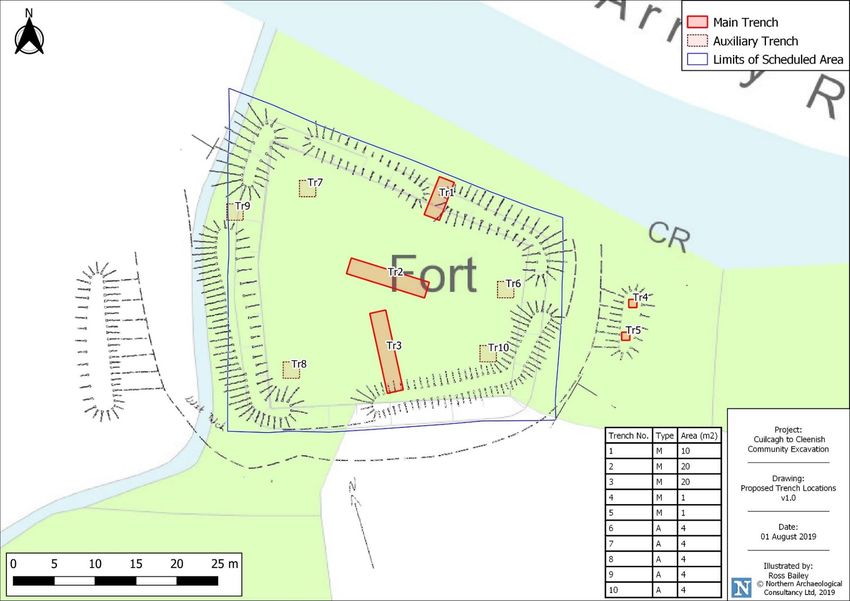
i

________________________________________________________________________________________________________________
Arney Fort, Co Fermanagh                                                                                  NAC Ltd
Archaeological Written Scheme of Investigation (v1)                                                   August 2019
Document No. 010819a
ii

                                                             Quality Management System                             Reference:            7.03D
                                                                                                                   Issue:                   03
                                                                 DESKTOP REPORT                                    Date:            26/06/2019
                                                        WRITTEN SCHEME OF INVESTIGATION                            Authorised:     QMS Manager

Site Name:                             Arney Fort, Marble Arch Road, Co. Fermanagh

Project Type:                          Written Scheme of Investigation

Commissioned by:                       Outdoor Recreation Northern Ireland on behalf of Cuilcagh to Cleenish: A Great Place

Author:                                Jonathan Barkley

NAC reference:                         ARF-CD1-FER

DEPARTMENT FOR COMMUNITIES; HISTORIC ENVIRONMENT DIVISION (DFC; HED) PERSONNEL WITH
RESPONSIBILITY FOR THIS PROJECT:
Historic Monuments Scheduling Team     Name: Gail Russell
                                       (e: Gail.Russell@communities-ni.gov.uk)
Historic Monuments Licensing Team      Name: Ronan McHugh
                                       (e: Ronan.McHugh@communities-ni.gov.uk)

Only NAC personnel can make alternations to this report, in order to adhere to our quality assurance guidance
all revisions/alternation must be approved by a senior member of staff and will be recorded on this page:

Rev       Date                                Details                              Reason         Prepared by   Checked by   Approved by   Doc No.
                                                                               SMC & Excavation
                       Arney Fort, Marble Arch Road, Co. Fermanagh; Written
 1     01.08.19                                                                    Licence         J Barkley     R Bailey     L Heaney     010819a
                       Scheme of Investigation
                                                                                 Applications

COPYRIGHT NOTE
Please note that the entirety of this report, including any original drawings and photographs, remain the property
of the author(s) and NORTHERN ARCHAEOLOGICAL CONSULTANCY LTD. Any reproduction of the said report
requires the written permission of NORTHERN ARCHAEOLOGICAL CONSULTANCY LTD. Images and drawings
supplied by third parties are acknowledged individually.

LPS/OSNI LICENCE
Where Ordnance Land and Property Services/Survey of Northern Ireland (OSNI) material has been reproduced in
this report it has been done so under licence number 2486.

THE COPYRIGHT LICENSING AGENCY
Where third party material has been reproduced in this report it has been done so under CLA licence BSRES16964.

Disclaimer:
It should be noted that much of the information used in this report draws on the existing records of public sector institutions and, although
reasonable effort will be made to avoid inaccuracy, NAC are not responsible for accidental perpetuation of inaccuracies or omissions in these
records and any consequent effect on the conclusions of this report. This report represents a good faith attempt at executing the stated aims,
but it must be understood that the assessment and recommendations are based purely on the data and resources noted in the text as having
been consulted. NAC are not responsible for any effect on the assessment and its recommendations that may be caused by not considering
resources beyond the parameters indicated below.

________________________________________________________________________________________________________________
Arney Fort, Co Fermanagh                                                                                  NAC Ltd
Archaeological Written Scheme of Investigation (v1)                                                   August 2019
Document No. 010819a
iii

________________________________________________________________________________________________________________
Arney Fort, Co Fermanagh                                                                                  NAC Ltd
Archaeological Written Scheme of Investigation (v1)                                                   August 2019
Document No. 010819a
iv

________________________________________________________________________________________________________________
Arney Fort, Co Fermanagh                                                                                  NAC Ltd
Archaeological Written Scheme of Investigation (v1)                                                   August 2019
Document No. 010819a
v

              CONTENTS

                       Executive Summary                                                            vi

              1        Introduction                                                                 1

              2        Location and Physical Setting                                                1

              3        The Scope of Investigation                                                   3

              4        Archaeological Context of the Site                                           4

              5        Archaeological Potential                                                     9

              6        Archaeological Scheme of Investigation                                      10

                                      Appendix 1: Landowner Agreement Letter                        I

________________________________________________________________________________________________________________
Arney Fort, Co Fermanagh                                                                                  NAC Ltd
Archaeological Written Scheme of Investigation (v1)                                                   August 2019
Document No. 010819a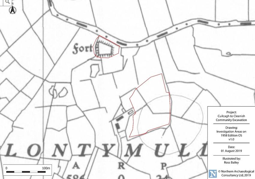
vi

________________________________________________________________________________________________________________
Arney Fort, Co Fermanagh                                                                                  NAC Ltd
Archaeological Written Scheme of Investigation (v1)                                                   August 2019
Document No. 010819a
vii

                                                            EXECUTIVE SUMMARY

  Site Name:                              Arney Fort, Co. Fermanagh
  County:                                 Fermanagh
  Planning Reference:                     n/a
  Planning Condition Nos:                 n/a
  ITM:                                    622098 836441
  Irish Grid Ref:                         Eastings:             222149                        Northings:       336426
  Records Reviewed                                                             Yes                    If No, provide reason
  A: HISTORIC ENVIRONMENT RECORD FOR NORTHERN IRELAND
     i    NI Site & Monuments Record (NISMR)                                   ☒
    ii    Industrial Heritage Record (IHR)                                     ☒
   iii    Register of Historic Parks, Gardens & Demesnes                       ☒
   iv     Defence Heritage Record                                              ☒
    v     Maritime Heritage Record                                             ☒
   Vi     Listed Buildings                                                     ☒
   vii    Battle Sites                                                         ☒
  B: STATUTORY DESIGNATIONS – ARE ANY PRESENT:
     i    State Care Site                                                      ☒
    ii    Scheduled Monument Site                                              ☒
  C: LOCAL DEVELOPMENT PLANS FOR RELEVANT DESIGNATIONS & ZONINGS
     i    Areas of Significant Archaeological Interest (ASSI)                  ☒
    ii    Areas of Archaeological Potential (AAP)                              ☒
  D: REVIEW OF PREVIOUS ARCHAEOLOGICAL INVESTIGATIONS                          ☒
  E: REVIEW OF CARTOGRAPHIC MATERIAL                                           ☒
  F: REVIEW OF AVAILABLE HISTORIC & MODERN AERIAL PHOTOS                       ☒
  G: FINDSPOT RECORDS AT ULSTER MUSEUM                                         ☒
  H: HISTORIC RECORDS HELD AT PRONI                                            ☒
  I: BIBLIOGRAPHIC REVIEW                                                      ☒

  Walkover Survey undertaken & results included?                               ☒
  Has the Health & Safety Risk Assessment been updated for the                 ☒
  site?
  Has the Environmental Risk Assessment been updated for the                   ☐     To be done with risk assessment
  site?
  Assessment of Archaeological Potential?                                      ☒
  Assessment of Archaeological Impacts?                                        ☒
  Archaeological Mitigation Strategy required?                                 ☒

  Summary of Recommended Mitigation Strategy:
  Five trenches measuring 52m2 (3.5% of the site), with a proposed further 20m 2 that could be opened if
  required.

  Additional Works Required:                                              Geophysical survey of fort interior & metal detecting survey

________________________________________________________________________________________________________________
Arney Fort, Co Fermanagh                                                                                  NAC Ltd
Archaeological Written Scheme of Investigation (v1)                                                   August 2019
Document No. 010819a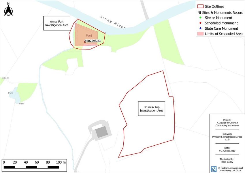
viii

________________________________________________________________________________________________________________
Arney Fort, Co Fermanagh                                                                                  NAC Ltd
Archaeological Written Scheme of Investigation (v1)                                                   August 2019
Document No. 010819a

1
1 INTRODUCTION
1.1 This Archaeological Written Scheme of Investigation was prepared in July 2019 by Northern
Archaeological Consultancy Ltd, having been commissioned by Outdoor Recreation Northern Ireland on
behalf of Cuilcagh to Cleenish: A Great Place.
1.2 The client wishes to undertake a community excavation, comprising geophysical survey, hand-excavated
test trenches and limited metal detecting, on the site of the scheduled Arney Fort (FER229:023) and
adjacent drumlin. The aim of this project is to investigate the fort and to try and ascertain the function
and period of the site. This written scheme of investigation is designed to facilitate this by detailing an
archaeological programme of investigation suitable to obtaining Scheduled Monument Consent and an
excavation licence.
2 LOCATION AND PHYSICAL SETTING
LOCATION
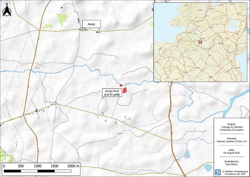
2.1 The investigation site lies on the southern bank of the Arney River, approximately 1km north of the
Marble Arch Road (222173E, 336411N) (Figure 1). The site lies in the townland of Clontymullan, in the
parish of Killesher, Barony of Clanawley, in the county of Fermanagh.
Figure 1: General location of Proposed Investigations
________________________________________________________________________________________________________________
Arney Fort, Co Fermanagh NAC Ltd
Archaeological Written Scheme of Investigation (v1) August 2019
Document No. 010819a2
PHYSICAL BACKGROUND
2.2 The site of the fort sits beneath the 50m OD contour, on the southern bank of the Arney River, and lies
on topsoil and superficial deposits of lacustrine alluvium (clay, silt, sand, sand and gravel unlithified
deposits) laid down by the same river. The investigation area on the drumlin sits on and above the 60m
OD contour, in an area of topsoil of poor drainage surface water gleys of shale-, limestone- and sandstone
till parent material, atop superficial geology of the same glacial till. Both areas lie atop bedrock of
calcareous mudstone and limestone of the Bundoran Shale Formation.
PROPOSED SITE AT PRESENT
2.3 The site of the proposed investigations comprises the scheduled area for FER229:023 and the top of the
drumlin that lies approximately 200m to the southeast. The two areas to be investigated comprise Arney
Fort (approx. 1494m2) and the top of the adjacent drumlin (approx. 11,000m 2)
2.4 The area of Arney Fort is currently covered in trees, but Scheduled Monument Consent has been granted
to allow removal of the majority of the trees and open up the interior of the fort. The drumlin is currently
unimproved pasture.
Figure 2: Location of Proposed Investigation Areas
________________________________________________________________________________________________________________
Arney Fort, Co Fermanagh NAC Ltd
Archaeological Written Scheme of Investigation (v1) August 2019
Document No. 010819a3
3 SCOPE OF INVESTIGATION
3.1 The proposed investigations are intended to allow the Cuilcagh to Cleenish: A Great Place partnership to
undertake a community-based excavation and survey under the direction and direct supervision of
professional archaeologists. The investigations would be centred on the site of Arney Fort, a trapezoidal
enclosure that lies on the banks of the Arney River, and the top of an adjacent drumlin that may also be
connected with the site.
3.2 It is proposed that a series of both invasive and non-invasive techniques be utilised in order to facilitate
the investigation. These include geophysical surveys of the centre of Arney Fort and the top of the
adjacent drumlin, limited hand-excavated test trenches within the centre of the fort to try and identify
structures that may have been present, and metal-detecting surveys of the arisings from the excavation,
the area between the fort and the river and the top of the adjacent drumlin.
3.3 This report is intended only to detail suitable works for these proposed investigations.
________________________________________________________________________________________________________________
Arney Fort, Co Fermanagh NAC Ltd
Archaeological Written Scheme of Investigation (v1) August 2019
Document No. 010819a4
4 ARCHAEOLOGICAL CONTEXT OF THE INVESTIGATION SITE
ARCHAEOLOGICAL SITES WITHIN THE PROPOSED INVESTIGATION
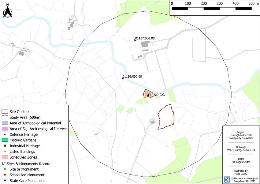
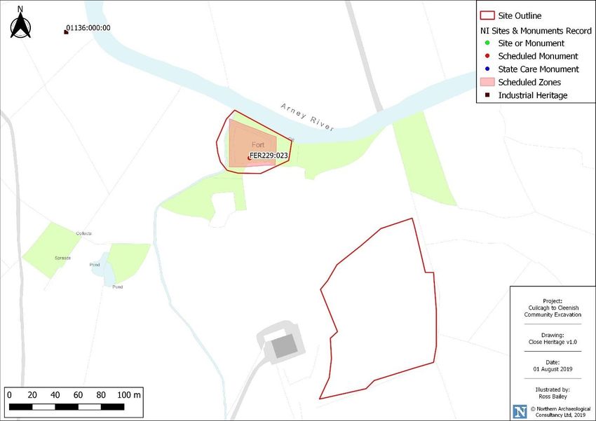
4.1 The investigation area comprises the scheduled zone for Arney Fort enclosure FER229:023 and the top
of the drumlin that is located to the southeast of the enclosure (Figures 3 & 4).
Figure 3: Archaeological and Heritage sites within the investigation areas
FER229:023 – SCHEDULED RATH
4.2 The investigation site comprises the FER229:023 scheduled area, marking the extent of the enclosure of
Arney Fort that is recorded as a rath:
FER229:023
Rath
Situated on the S bank of the Arney River. This is a trapezoidal enclosure 36m long NW-SE & 31.5m at
the NW end narrowing to 15m at SE. The level interior is enclosed by almost straight earthen banks
6.7m wide, 1.1m high internally & 2m above a ditch which is 2.5m wide & 0.2m deep. It survives as a
shallow, wet feature in an arc ESE-S-NW. There are slight remains of an outer bank 4.5m wide at SE &
W-NW. There are 5 gaps in the inner bank & it is not clear which of them may have been original.
NISMR File
4.3 The shape, general layout, and topographical position of the monument does not, however, conform to
our current understanding of raths, and it seems much more likely that this is misclassified. One of the
primary aims of the investigation is to aid in the correct reclassification of the site, as further discussed
in Section 5.
________________________________________________________________________________________________________________
Arney Fort, Co Fermanagh NAC Ltd
Archaeological Written Scheme of Investigation (v1) August 2019
Document No. 010819a5
Figure 4: Archaeological and Heritage sites within the surrounding area
PREVIOUS ARCHAEOLOGICAL WORK IN THE SURROUNDING AREA
4.4 A previous community excavation was undertaken in 2014, under licence AE/14/01E, and was
concentrated on the original village of Arney; located approximately 1.50km to the northwest of the site.
As part of these investigations a metal detector survey was undertaken to try and identify the location
of the 1894 Battle of the Ford of the Biscuits, which is recorded in the Northern Ireland SMR as being at
Drumane Bridge, approximately 1.4km to the east of the site. The results of the metal detecting survey
showed that the most likely location for the battle was actually 2km to the west of Drumane Bridge, and
approximately 500m west of Arney Fort.
ARCHAEOLOGICAL FINDSPOTS
4.5 A search for findspots of archaeological objects within the townland of Clontymullan was carried out
using the computerised database at the Ulster Museum, Belfast. No objects were recorded from
Clontymullan, nor from the adjacent townland of Ross.
4.6 Despite this, two objects are known to have been recovered from the approximate location of the Ford
of the Biscuits. A Late Bronze Age sword was discovered in 1965 by a local landowner and now resides
in Fermanagh County Museum. It has also been reported that a Bronze Age socketed axe was discovered
by a metal detectorist close to the site of the Ford of the Biscuits.
________________________________________________________________________________________________________________
Arney Fort, Co Fermanagh NAC Ltd
Archaeological Written Scheme of Investigation (v1) August 2019
Document No. 010819a6
OTHER MAPPED HERITAGE IN THE SURROUNDING AREA
4.7 Other mapped heritage within the 500m study area comprised two Industrial Heritage sites (Figure 4),
both clay hole or brickfield sites.
IHR/LB No. Type Townland Location Grid Ref
01136:000:00 Brickfield Clontymullan South of Arney River H21993653
01137:000:00 Clay Hole / Brickfield Ross North of Arney River H22073677
Table 1: Other mapped heritage within the study area
THE INVESTIGATION SITE ON AERIAL PHOTOGRAPHS
4.8 A search of the aerial photography databases did not reveal anything of a clear archaeological nature
within the investigation area boundaries, other than the heavily tree covered Arney Fort.
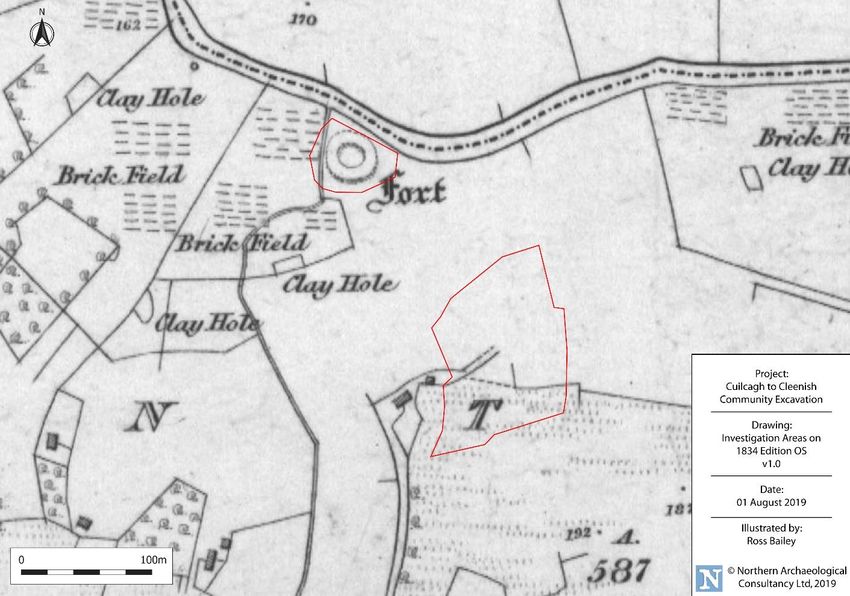
THE APPLICATION SITE ON EARLY OS MAPS
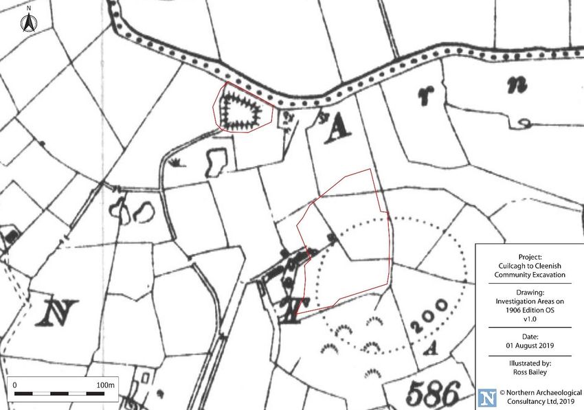
4.9 The 1st edition of the Ordnance Survey map showed the enclosure as being circular (Figure 5). In the 2 nd
edition (Figures 6) the enclosure is shown as being ‘D’ shaped. By the time of the 3 rd edition (Figure 7)
the enclosure is more accurately shown as being trapezoidal in shape.
Figure 5: Ordnance Survey 1st edition six-inch map, investigation areas in red
________________________________________________________________________________________________________________
Arney Fort, Co Fermanagh NAC Ltd
Archaeological Written Scheme of Investigation (v1) August 2019
Document No. 010819a7
Figure 6: Ordnance Survey 2nd edition six-inch map, investigation areas in red
Figure 7: Ordnance Survey 3rd edition six-inch map, investigation areas in red
________________________________________________________________________________________________________________
Arney Fort, Co Fermanagh NAC Ltd
Archaeological Written Scheme of Investigation (v1) August 2019
Document No. 010819a8
Figure 8: Ordnance Survey 1958 edition map, investigation areas in red
________________________________________________________________________________________________________________
Arney Fort, Co Fermanagh NAC Ltd
Archaeological Written Scheme of Investigation (v1) August 2019
Document No. 010819a9
5 ARCHAEOLOGICAL POTENTIAL
ARCHAEOLOGICAL POTENTIAL
5.1 Despite the categorization of Arney Fort as a rath the site is trapezoidal in shape rather than circular.
The SM7 file for the site notes that “There are no other comparable sites in the county” and, further to
this, it’s location adjacent to the river and the overall proportions of the fort make this an important
strategic site.
5.2 Recent works on settlement in late medieval Gaelic Ireland have identified a number of sub-rectangular
or trapezoidal enclosures that appear to be similar in style to/the same as the moated sites in the areas
of Ireland that were under Anglo-Norman control.
5.3 Work has been undertaken by T. Finan and K. O’Connor (2002) on the trapezoidal moated site at
Cloonfree, Co. Roscommon, in comparing the monument with the description of the site in two
contemporary bardic poems. Here the site is recorded in 1306 as belonging to Aodh O’Connor, the king
of Connacht. Descriptions within the text describe the bank with a palisade fence, a potential gatehouse
structure at the entrance, the presence of a large timber banqueting hall and other possible houses or
buildings within the interior of the fort.
5.4 While it cannot currently be stated that Arney Fort is a Gaelic moated site, its size and form is more in
keeping of this site type than that of an early medieval rath.
5.5 The drumlin located to the southeast of Arney Fort is a commanding high point that overlooks the fort
and the river. As a strategic high point there is the potential that this site was utilised throughout the
prehistoric and historic periods.
5.6 As well as the clear archaeological potential of the fort, the discovery of two Late Bronze Age artefacts,
the sword and the socketed axe, approximately 500m to the west is a clear indication of Bronze Age
activity within the local area. There is also a potential for material related to the 1594 Battle of the Ford
of the Biscuits to be uncovered, it too probably having taken place at the same approximate location as
the find of Bronze Age artefacts.
________________________________________________________________________________________________________________
Arney Fort, Co Fermanagh NAC Ltd
Archaeological Written Scheme of Investigation (v1) August 2019
Document No. 010819a10
6 ARCHAEOLOGICAL SCHEME OF INVESTIGATION
ENVIRONMENTAL GOOD PRACTICE FOR ARCHAEOLOGISTS
6.1 All archaeological works on this project by NAC Ltd, and its staff, will be undertaken in line with the
guidance contained within the NIEA Environmental Good Practice Guide for Archaeological Excavations
document:
http://www.doeni.gov.uk/niea/environmental_guide_for_archaeological_excavations_version_3-
january_2012.pdf
6.2 The client has been made aware of the following section of the NIEA Environmental Good Practice Guide
for Archaeological Excavations document (see below) and have their own environmental policies in place
to account for this risk.
Archaeological excavations, almost by definition, involve the disturbance and movement of soil
and subsoil. Disturbance and movement of these materials, however, greatly increases the risk
that they could run into and pollute surrounding watercourses. Therefore, where archaeological
excavations are to take place close to rivers, lakes or other watercourses, careful consideration
should be given before the work commences by both the contractors and the body responsible
for the excavations to ensuring that no pollution will be caused by the proposed works. If the
work to be carried out is within close proximity (less than 100m) to a watercourse of any kind
the Water Management Unit of the DAERA should be supplied with a detailed method of work
statement prior to any works commencing so that appropriate advice/consent can be given.
HEALTH AND SAFETY
6.3 A risk assessment for the archaeological works will be prepared in advance of the work proceeding on
site by NAC’s Health & Safety officer. Copies of the risk assessment will be made available to the client
and DfC: HED on request.
HAND EXCAVATED TEST TRENCHES
6.4 An archaeological, hand-excavated test trenching layout (Figure 9, Table 2) has been devised. This is
focused on the interior of Arney Fort and each trench has been situated so as to enable specific queries
about the site to be addressed.
6.5 It is proposed that five test trenches be excavated within the interior of the fort. These trenches cover
a total area of 52m2, compared to the 1494m2 area of the fort. This equates to an excavation area of
approximately 3.5% of the fort. The recommendations for each trench are as follows:
6.6 Trench 1 (5m long x 2m wide) – Although there are five breaks in the banks of the fort it is unclear which
of these may have been the original entrance. Trench 1 has been located at the entrance that would
have, most likely, provided access to and from the adjacent Arney River. The trench has been located
so as to encompass the potential entrance way and to try and identify any surfaces that are present as
________________________________________________________________________________________________________________
Arney Fort, Co Fermanagh NAC Ltd
Archaeological Written Scheme of Investigation (v1) August 2019
Document No. 010819a11
well as any potential entrance structure. Further to this it is intended that this trench will also examine
the make-up of the bank by partially excavating and straightening one of the existing eroded sections.
6.7 Trench 2 (10m long x 2m wide) – The trench has been located centrally within the fort and aligned
perpendicular to the potential entrance at the river. The aim of this trench is to establish whether there
was a central structure or hall within the fort.
6.8 Trench 3 (10m long x 2m wide) – This trench has been located at the southern side of the fort, extending
from the base of the bank towards the centre of the site. This trench will aim to identify whether there
were any structures associated with or constructed adjacent to the bank of the fort. By extending the
trench towards the centre of the site, and towards Trench 2, if a structure was present within the centre
of the fort then it should be further identified and defined within this trench.
6.9 Trenches 4 and 5 (1m long x 1m wide) – These two trenches have been located on the small ‘D’ shaped
annex located to the east of the main enclosure. The function of this annex is unclear, as it is separated
from the main fort by the ditch but is itself enclosed by a further section of ditch on its eastern side. The
excavation of these two trenches may provide evidence for the purpose of or activities that were taking
place on this annex.
Trench Area (m2)
1 10m2
2 20m2
3 20m2
4 1m2
5 1m2
Total 52m2
Table 2: Proposed test trenches
(N.B. This trench layout should be taken as indicative. Due to the presence of trees throughout the site
trenches may need to be staggered so as to avoid trees and root structures. Any alterations to the
trenching layout will be agreed with HED prior to excavation.)
________________________________________________________________________________________________________________
Arney Fort, Co Fermanagh NAC Ltd
Archaeological Written Scheme of Investigation (v1) August 2019
Document No. 010819a12
Figure 9: Proposed Test Trench and Auxiliary Test Trench layout for Arney Fort
________________________________________________________________________________________________________________
Arney Fort, Co Fermanagh NAC Ltd
Archaeological Written Scheme of Investigation (v1) August 2019
Document No. 010819a13
RESERVE EXCAVATION AREA
6.10 It is further proposed that 20m 2 be held in reserve to be utilised should it be required. The requirement
for the reserve excavation area will be determined by the nature of any archaeological material that is
uncovered within the original five proposed test trenches.
6.11 It is proposed that should archaeological evidence for structures, etc., be encountered then it may be
necessary to extend one or more of the original trenches in order to try and establish the scope or limits
of the archaeology encountered.
6.12 Should some or all of the test trenches (1 – 5) fail to uncover archaeological remains then it is proposed
that the 20m2 be utilised in opening further test trenches to try and identify whether remains are present
within the fort, providing that sufficient time allows for excavation and recording. Five test trenches (6 –
10), each measuring 2m long by 2m wide, are proposed and indicative locations are shown.
6.13 Any extension to the excavation areas or opening of new test trenches will be agreed with HED prior to
excavation being undertaken.
6.14 Trench 6 – This trench has been located towards a gap in the banks on the eastern side of the fort. This
break in the bank may have provided access to the annex that lay on the opposite side of the ditch and
the trench has been located so as to examine any potential paths or structures that may have been
present. Due to the presence of trees within the current break in the banks the trench has been located
to the west of potential entrance rather than directly over it.
6.15 Trench 7 – This trench is located in the northwest corner of the fort and has been positioned to examine
the possibility of ancillary structures, workshops, etc., being located on the periphery of the interior of
the fort.
6.16 Trench 8 – This trench is located in the southwest corner of the fort and, like Trench 7, has been
positioned to examine the possibility of structures being located on the periphery of the enclosure. It is
also positioned close beside the southern break in the banks with a view to examining the possibility that
this was an original entrance and whether any associated structures are present.
6.17 Trench 9 – This trench is located over the break in the banks at the western side of the fort. The aim of
this trench is to examine whether there is any evidence that this was an entrance and if so whether any
structure was present.
6.18 Trench 10 – This trench has been located at the southeast corner of the interior to examine the possibility
of structures being present immediately beside the bank.
________________________________________________________________________________________________________________
Arney Fort, Co Fermanagh NAC Ltd
Archaeological Written Scheme of Investigation (v1) August 2019
Document No. 010819a14
EXCAVATION METHODOLOGY
6.19 The site is currently covered in trees, though clearance of these should be undertaken prior to the start
of the excavation. On the first day Trenches 1 and 2 will be marked out and de-sodded. The volunteers
will then begin the excavation of these trenches. No further trenches will be opened until the excavation
and recording of each trench is nearing completion.
6.20 Each trench will be excavated in 5cm deep layers, until either an archaeological layer or subsoil is
reached.
6.21 The volunteers will be supervised at all times by qualified archaeologists and if or when archaeological
layers or features are encountered they will be shown how to excavate and then record what they have
found. At the start of each session there will be an explanation of the methodology of what the volunteers
have to do, and each person will be provided with a written guide on how to excavate and how to record
the archaeology. The aim is to ensure that the volunteers undertake as much of the work as possible so
that they gain a full archaeological experience and ensuring that this is a fully integrated community
excavation. During the excavation the volunteers will sieve all spoil created and, possibly, undertake the
cleaning of any artefacts that may be uncovered. The cleaning of artefacts will depend on the type and
preservation of the artefacts uncovered and any decision on this will take place if and when the time
arises.
6.22 During the course of the excavation NAC will have a staff of five experienced archaeologists present to
help and guide the volunteers and to ensure that the excavation, while still community based, is
undertaken to the highest standard.
6.23 As soon as archaeological material is uncovered the site director (Jonathan Barkley) will inform the HED
archaeological inspectors (Ken Neill and Ronan McHugh) by phone. If substantial remains are uncovered
it is proposed that the site director submit daily updates by email to Ken Neill and Ronan McHugh and
accommodate and encourage their visits to the site in order to view the progress and to discuss the best
way to proceed.
6.24 No mechanical machinery will be allowed on the site; all excavation and backfilling will be done by hand.
GEOPHYSICAL SURVEY
6.25 It is proposed that a geophysical survey of the interior of the monument and the top of the drumlin be
undertaken. The survey of the interior of the monument will be undertaken in the week prior to the
excavation taking place and, providing the data has been processed, may be used to refine the test
trenching layout. If the results of the survey require any change to the proposed test trenches this will
only be done following discussion and agreement with HED.
6.26 It is further proposed that the top of the drumlin also be subject to geophysical survey.
________________________________________________________________________________________________________________
Arney Fort, Co Fermanagh NAC Ltd
Archaeological Written Scheme of Investigation (v1) August 2019
Document No. 010819a15
6.27 The proposals for geophysical survey and the survey locations will be subject to a separate programme
of works and licence application to be submitted by Earthsound Geophysics Ltd.
METAL DETECTING METHODOLOGY
6.28 It is proposed that during the course of the excavation of the test trenches within the fort a programme
of metal detecting is also undertaken. It is proposed that a three-phase approach for metal detecting be
undertaken:
6.29 Phase 1: Metal detecting be undertaken of the arisings from the excavation of the test trenching to be
systematically undertaken to ensure that no small artefacts (pins, etc.,) are missed.
6.30 Phase 2: Metal detecting to be undertaken outside but in the immediate vicinity of Arney Fort and the
Arney River. At the location of a previously existing ford, further along the river to the west, a Bronze
Age sword was recovered. Further to this a Bronze Age socketed axe was also recovered from material
that had been dredged from the river at approximately the same location. With Bronze Age artefacts,
the potential medieval/later medieval date of the fort and the late 16 th century Battle of the Ford of the
Biscuits having taken place nearby the potential for metal artefacts to have been dropped or deposited
in or beside the river is high.
6.31 Phase 3: Metal-detecting to be undertaken in transects across the top of the drumlin.
HUMAN REMAINS
6.32 Given the proximity of the site to the location of the Battle of the Ford of the Biscuits there is a possibility
that human remains could be uncovered during the excavation. If human remains, or any suspected
grave cuts, are observed, excavation by the volunteers in that area will cease and the remains will be
covered over. The Police Service of Northern Ireland (PSNI), HED area archaeologists Ken Neill and
Ronan McHugh will be informed immediately. If the remains have to be excavated a suitable methodology
for dealing with the human remains or grave cuts will be agreed in writing with HED. Work will not
recommence in the area containing the human remains until such a methodology has been agreed, and
all works subsequently undertaken in this area will be in accordance with this methodology. Any
excavation of human remains will only be undertaken by qualified archaeologists, no volunteers will be
allowed to excavate the remains. If there is no valid reason to excavate the remains, they will be fully
recorded by a qualified archaeologist and their location surveyed. As per the Excavation Licence any
human remains which are uncovered must immediately be reported to the Police Service of Northern
Ireland.
SPOIL MANAGEMENT AND SITE RE-INSTATEMENT
6.33 NAC staff will ensure the spoil heaps are safely and sufficiently managed. The site will be backfilled, and
the de-sodded turf re-laid, which will have been set to one side at the beginning of the excavation.
________________________________________________________________________________________________________________
Arney Fort, Co Fermanagh NAC Ltd
Archaeological Written Scheme of Investigation (v1) August 2019
Document No. 010819a16
SURVEY METHODOLOGY
6.34 The location of all excavated trenches (each corner point) shall be surveyed using appropriate GPS
equipment and a digital scaled map provided as part of any subsequent report. This will allow for the
excavated test trenches and any features that are uncovered to be accurately positioned within the fort.
RECORDING AND EXCAVATION
6.35 Features discovered during test trenching will be excavated. If time does not allow for excavation and
recording of all features then preservation in-situ will be undertaken. Those features that are discovered
and excavated must be planned, sampled, recorded and written up. All archaeological works and
structural recording will be carried out in accordance with the Standard and Guidance for Archaeological
Field Evaluation prepared by the Chartered Institute for Archaeologists (CIfA) (IfA 2008), the CIfA Code
of Conduct (IfA 2012), Understanding Historic buildings – a guide to good practice prepared by English
Heritage (2006) and the Environmental Good Practice Guide for Archaeological Excavations, Version 4
(NIEA 2012).
• DfC: HED currently policy indicates that 100% excavation should be considered for most
features, however larger features (e.g. long ditches) and those features which have been
identified as modern during initial examination may require a lesser degree of excavation
and recording. Any changes to 100% excavation and recording will require prior approval
from DfC: HED.
• The discovery of possible treasure items (as defined by the Treasure Act 1996 and the
Treasure (Designation) Order 2002) must be reported at once to the DfC: HED.
• The actual areas of trenching and any features of possible archaeological concern noted
within the trenches, must be accurately located on a site plan and recorded by photographs,
summary scale drawings, and written descriptions.
• All trenches which contain archaeological features will be planned at 1:50, with individual
features being planned at 1:20 where additional detail is required. Sections and profiles of
each feature sampled will be drawn at 1:10 or 1:20, depending on the size of the feature.
All plans, sections and profiles will be related to Ordnance Datum, in metres.
ARCHAEOLOGICAL PERSONNEL
6.36 All of the archaeological measures outlined in this section will be carried out by volunteers under
supervision from five professional archaeologists. There will no be no more than 10 volunteers excavating
at any one time ensuring a ratio of one archaeologist to two volunteers. All archaeological work will be
carried out under the direction of the archaeological licence holder.
POST-EXCAVATION WORK AND FINAL REPORT
6.37 In addition to funding the fieldwork, the post-excavation analysis of the findings and the writing up of
the findings by the licensed archaeologist will be funded. Funding may also be required for specialist
archaeological services, such as radiocarbon dating, osteoarchaeology, etc., depending on the nature on
any discoveries. These services are a basic requirement for the assessment of some types of evidence.
The post-excavation process will be monitored by the client and HED. It is intended that a talk will be
________________________________________________________________________________________________________________
Arney Fort, Co Fermanagh NAC Ltd
Archaeological Written Scheme of Investigation (v1) August 2019
Document No. 010819a17
given on the results of the excavation in November 2019 to the public and interested parties. Where
significant archaeological material is encountered the results will be published as both academic and
popular reports, at a level of detail appropriate to the works, and as agreed by the client and HED.
THE LICENSED ARCHAEOLOGIST
6.38 The nominated Licence holder (Site Director) will provide the DfC: HED case officer with contact details,
i.e. mobile phone number, in advance of fieldwork. The site director will contact and inform the case
officer, in advance, of the date when archaeological works are due to begin on site. The case officer will
be given regular verbal updates regarding progress of the works and notified immediately of all new
discoveries. The site director will contact and inform the case officer, in advance, of the date when
archaeological mitigation work is due to finish on site. The site director will forward the case officer a
map (of appropriate scale) illustrating the precise area evaluated within fourteen days of the end of
archaeological works.
ARTEFACT AND MATERIAL STORAGE
6.39 Archives will be created and stored in line with best practice as defined by the Archaeological Archives
Forum of the Council for British Archaeology:
http://www.archaeologyuk.org/archives/Archives_Best_Practice.pdf
6.40 All materials (paper and artefactual) deriving from the works will be stored at a location to be agreed
with the client.
7 BIBLIOGRAPHY
Finan, T. and O'Connor, K. (2002) 'The Moated Site at Cloonfree, Co. Roscommon', Journal of the Galway
Archaeological and Historical Society, 54, pp. 72-87.
________________________________________________________________________________________________________________
Arney Fort, Co Fermanagh NAC Ltd
Archaeological Written Scheme of Investigation (v1) August 2019
Document No. 010819aYou can also read