Transport Statement for Hillmorton Primary School Warwickshire County Council
←
→
Page content transcription
If your browser does not render page correctly, please read the page content below
Transport Statement
                            for
   Hillmorton Primary School
Warwickshire County Council

               Issue Number 01
                       25/01/16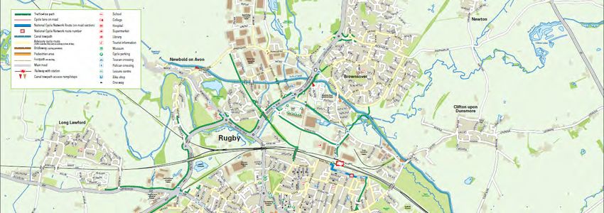
Document History
Issue   Date         Comment         Author     Chk’d
01      25/01/2016                   NJB        M-LH

                               Transport Statement
                                  Issue Number 01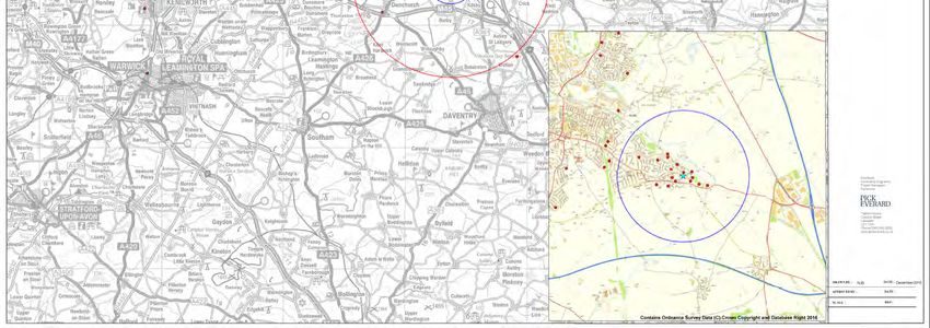
Contents
1.0     Introduction ....................................................................................................... 1

2.0     Existing Site Information .................................................................................. 1
2.1     Site Location                                                                                                1
2.2     Existing Site Operation                                                                                      2
2.3     Existing Site Access                                                                                         2
2.4     Existing School Vehicle Parking Facilities                                                                   5
2.5     Deliveries and Servicing                                                                                     6
2.6     Existing School Cycle and Scooter Facilities                                                                 7

3.0     Baseline Transport Data ................................................................................... 7
3.1     Highway Network                                                                                             7
3.2     Public Transport                                                                                          10
3.3     Pedestrian and Cycle Routes                                                                               12
3.4     Local Parking                                                                                             14

4.0     Proposed Development .................................................................................. 19
5.0     Construction .................................................................................................... 19
5.1     Construction Access                                                                                               19
5.2     Construction Parking and Compound                                                                                 20

6.0     Trip Generation............................................................................................... 20
6.1     Existing Trips                                                                                                 20
6.2     Development Trips                                                                                              22

7.0     Traffic Impact of Proposed Development ..................................................... 23
7.1     On-Site Parking                                                                              23
7.2     On-Street Parking                                                                            24
7.3     Opportunities for Modal Choice                                                               24

8.0     Conclusions ...................................................................................................... 26

Appendix A
Rugby Cycle Map

Appendix B
Postcode Plots
•       Staff Plots
•       Pupil Plots

Appendix C
Hillmorton Primary School Proposal Drawings

                                                                                           Transport Statement
                                                                                              Issue Number 01
1.0   Introduction

      As part of the programme to increase the number of school places in Warwickshire, it is
      proposed to expand Hillmorton Primary School. The school currently has one form of
      entry and it is proposed to increase to two forms of entry.

      It has been agreed in consultation with the local authority that a Transport Statement
      should be prepared for submission with the planning application for this development.
      The following Transport Statement considers the existing transport and traffic situation
      both at the school site and in the immediately surrounding area. It discusses the
      opportunities for access to all local multi-modal transport networks, the development
      proposals are discussed as is the nature of the additional trips that the development will
      generate, together with the likely transport impacts of the development.

2.0   Existing Site Information

2.1   Site Location

      The address of Hillmorton School is Watts Lane, Hillmorton, Rugby, Warwickshire CV21
      4PE. It is located within a residential area. It is a 13 minute walk (966 metres) to a
      neighbouring school, English Martyrs Roman Catholic Primary School.
      The school entrance is directly opposite a cemetery. See Figure 2.1.

      Figure 2.1 Plan of School Local Area

                      A428

                                                                       Transport Statement
                                                                                                   1
                                                      MC/MPC/M-LH/NJB/151076/17-2/R001-01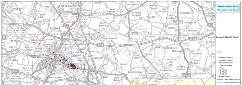
2.2     Existing Site Operation

        The school site as a whole caters for pupils aged 3 to 11 from nursery to Year 6. There are
        currently 223 pupils on roll at the school plus 41 pre-school children enrolled in the
        nursery. 44 members of full and part time staff are employed at the school and nursery.

        The nursery runs two sessions from 09:00 to 11:45 and from 12:30 to 15:30 consisting of
        around 25 and 16 children respectively. The three nursery staff members are present from
        08:30 until 16:15, covering all sessions.

        The expansion of pupils attending the school has already started from September 2015.
        There are 30 extra Reception pupils on site which equates to one additional class.

        Teachers are able to enter the school from 07:00, when the caretaker opens the building.
        Teaching assistants generally arrive around 08:30. The school opens to pupils from 08:00
        when there is a breakfast club. Around 15 children attend this. The formal school day
        begins at 08:50, and finishes at 15:30, with afterschool clubs running until 16:30 every day
        except Friday. Around 30 children stay at school and attend these clubs. Teaching assistants
        generally leave from 15:30. Teachers may stay until the caretaker locks up the school at
        18:00.

        Some pupils attend an after school club from 15:30 to 18:00 called Marty’s, which takes
        place at English Martyrs Primary School daily. Children from Hillmorton School are
        accompanied by English Martyrs staff to the club, either by car or walking.

        Hillmorton Children’s Centre is located on the site. It offers a range of services, courses
        and training from agencies and it operates on a part time basis, meeting the needs of the
        wider school community, for example, health, social services and employment. It operates a
        crèche for 8 children, running to facilitate parents or carers attending the on-site services.
        The centre is run independently by Barnardos on Monday 09:00 – 15:30 and Wednesday
        08:30 – 16:30. There are times when hours are extended and it is likely that the centre will
        be open additional hours in the future. Generally no more than three members of staff
        attend the centre at any one time during the opening hours, with no staff or their visitors
        parking on the Hillmorton School site.

2.3     Existing Site Access

2.3.1   Vehicular Access

        There are two vehicular accesses to the school. The main access is off Watts Lane where
        staff members or visitors can enter to park. This is closed all day to encourage walking
        through the pedestrian access and not on the access road. Staff can open and close the
        vehicle gate when leaving or arriving as it is not locked, but closed by a bolt. Parents are
        not permitted to park on school grounds, with the exception of those picking up children
        who may have a disability. Another vehicle access is off Browning Road. This is only open if
        specialist vehicles are required to enter the school field such as maintenance vehicles. It is
        locked when not in use. See Photos 2.1 and 2.2 on page 3.

                                                                          Transport Statement
                                                                                                         2
                                                         MC/MPC/M-LH/NJB/151076/17-2/R001-01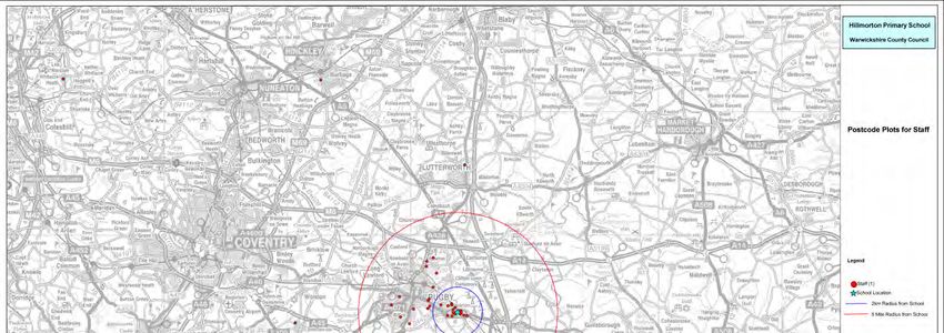
Photo 2.1 Main vehicular entrance

        Photo 2.2 Vehicular access at the rear of the field

2.3.2   Pedestrian Access

        There are two pedestrian accesses to the school. One is located adjacent to the vehicle
        access at the front of the school from Watts Lane, and the other is located at the back of
        the school, near the field vehicle access. The front school gate is closed but not locked
        throughout the day. This is the main pedestrian access. The field pedestrian access is locked
        during school time but unlocked and open at school start and finish times. This leads onto a
        footpath to Browning Road or onto Watts Lane. Street lights are present along here. Refer
        to Photos 2.3 to 2.6 on page 4 and Figure 2.2, on page 5.

        Photo 2.3 Primary school pedestrian access from Watts Lane

                            Pedestrian gate main access

                                                                         Transport Statement
                                                                                                    3
                                                        MC/MPC/M-LH/NJB/151076/17-2/R001-01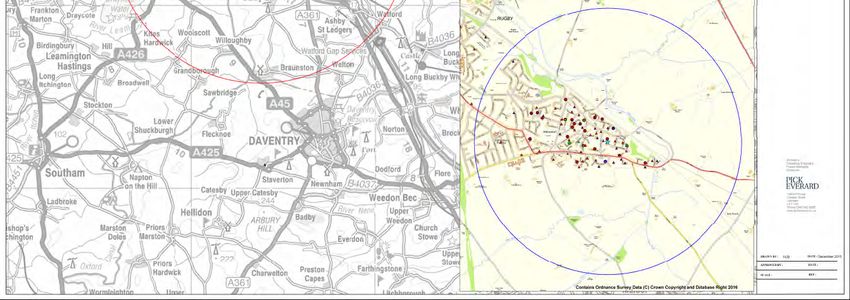
Photo 2.4 Rear access closed and locked during the school day

Photo 2.5 Rear access open at school finish time looking onto school grounds

Photo 2.6 Footpath from rear pedestrian access looking towards Browning Road.

                                                              Transport Statement
                                                                                    4
                                             MC/MPC/M-LH/NJB/151076/17-2/R001-01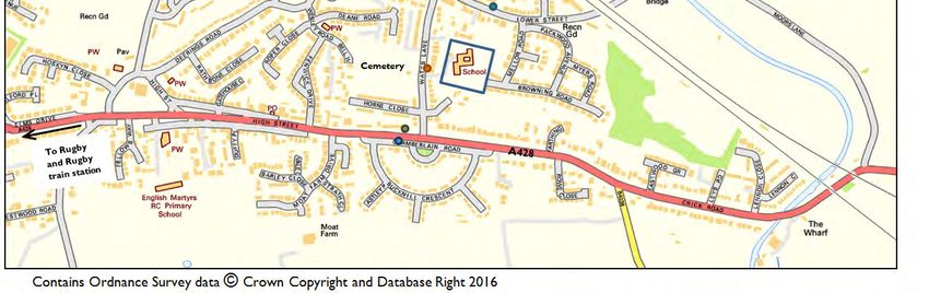
Figure 2.2 School pedestrian access

      To provide for the safety of pedestrians on the site the speed of cars is restricted by the
      use of a zebra crossing and speed bumps within the site. Refer to Photo 2.7. Tactile paving
      and dropped kerbs are present at the crossing.

      Photo 2.7 Speed bumps and zebra crossing on the school site

2.4   Existing School Vehicle Parking Facilities

      There are currently 17 marked vehicle parking spaces within the school grounds, plus one
      space for disabled users. 11 of these are located along the driveway as soon as the school is
      entered. See Photo 2.8 and 2.9 on page 6.

      A site visit and survey was carried out on Tuesday 08th December 2015. At around 13:15, it
      was observed that there were 17 cars parked in the school (the space for disabled users
      was vacant). Two of these cars were parked outside of the designated spaces within the
      school grounds, suggesting the car park was full earlier in the day and had overflowed into
      other areas. Two designated spaces were vacant.

                                                                       Transport Statement
                                                                                                  5
                                                      MC/MPC/M-LH/NJB/151076/17-2/R001-01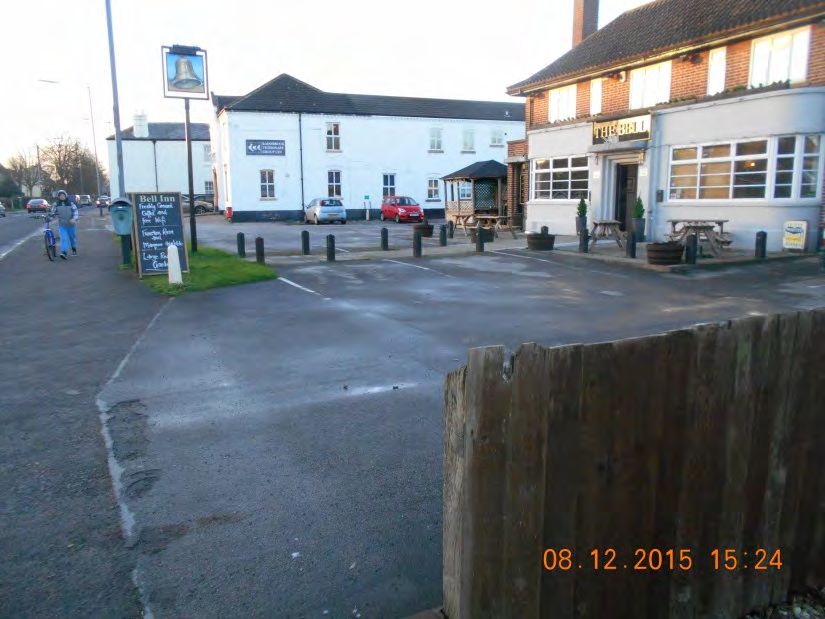
Photo 2.8 Parking just inside of main vehicle access

                            Vehicle access

      Photo 2.9 Vehicle parking in front of Children’s Centre, including one space for disabled
      users (there is no designated Children’s Centre parking)

                  Vehicle access

2.5   Deliveries and Servicing

      Deliveries and service vehicles all enter at the main vehicle access and most park at the
      front of the school outside reception. Kitchen deliveries park outside of the kitchen and
      report directly to the kitchen staff. See Photo 2.10. The photograph also shows two cars
      parked outside of designated spaces.

      Refuse and rubbish collection happens each morning at around 06:00. Keys to the school
      and refuse area are held by the people removing the refuse. Collecting early in the morning
      means that the refuse lorry would not cause impact on, or be impacted by other vehicle
      and pedestrian movements on site. Bins are located in front of the kitchen access, inside a
      gated area.
      Photo 2.10 Kitchens and refuse bins location.
               Kitchen access

                                                                      Transport Statement
                                                                                                    6
                                                     MC/MPC/M-LH/NJB/151076/17-2/R001-01
2.6     Existing School Cycle and Scooter Facilities

        There are currently no cycling or scooter facilities on site, although pupils have expressed a
        desire to cycle to school.

        The school have stated in the November 2015 Travel Plan that due to the busy roads
        bordering the school, they participate in cycling proficiency and cycle safety awareness in
        collaboration with Warwickshire County Council. This is offered to Year 6 pupils during
        the summer term.

        There are currently two members of staff who cycle to school, taken from the staff travel
        survey from November 2015. Their cycles are either left outside against the wall or in the
        Children’s Centre buggy park. See Photo 2.11. This is a sheltered area next to the building
        entrance. On the day of visiting the school, on Tuesday 08th December 2015, one cycle was
        parked here.

        Photo 2.11 Buggy park outside the Children’s Centre within Hillmorton School

3.0     Baseline Transport Data

3.1     Highway Network

3.1.1   Local Highway Network
        Refer to Figure 3.1 on page 8.

        Hillmorton Primary School is located on Watts Lane within a residential area on the east
        side of Hillmorton. Bordering the south of the area, at the end of Watts Lane, is the A428.
        The A428 is a 30mph road, however visual observations during the site visit on Tuesday
        08th December 2015 suggested that some vehicles travelled along this road at speeds in
        excess of the speed limit. These observations were also made by parents when surveyed
        for the November 2015 Travel Plan.

                                                                         Transport Statement
                                                                                                      7
                                                        MC/MPC/M-LH/NJB/151076/17-2/R001-01
Figure 3.1 Local Highway Network and Accessibility Plan
3.1.2 Wider Highway Network
Refer to Figure 3.2 on page 9.
Coventry is located 16 miles west of Hillmorton, along the A428. Continuing to travel west
beyond Coventry along the A45 leads to Birmingham, around 36 miles away from
Hillmorton. Lutterworth is around 9 miles north east of Hillmorton along the A426.
Continuing north from Lutterworth, either along the A426 or the M1, is Leicester,
approximately 25 miles away from the school. Northampton is 19 miles south east of
Hillmorton along the A428 and the M1.
Transport Statement
8
MC/MPC/M-LH/NJB/151076/17-2/R001-01Hillmorton School
Figure 3.2 Wider Highway Network
Transport Statement
9
MC/MPC/M-LH/NJB/151076/17-2/R001-013.2 Public Transport
3.2.1 Bus
There are five bus stops in close proximity to the school. These serve a range of different
bus services. See Table 3.1 and Figure 3.1 on page 8. There are regular services hourly
from the morning into the evening during the week. There are also services on Saturday
and Sunday if required. Bus service number 10 to Rugby Train station, is hourly from the
school.
Table 3.1 Bus Services in proximity to Hillmorton School
Service Distance of Stop
Route Frequency First and Last Service
Number from School
To Hillmorton To Newbold
Newbold Monday – Friday
Nearest Service Stop Glebe Estate 06:48 06:48
Every 30 minutes approx.
From Existing School Town Centre (Rugby) 19:33 19:33
Saturday
3 Access Hillmorton 07:26 07:26
16 metres, 1 minute (some reversed– always Every 30 minutes approx.
walk on Watts Lane. southbound past bus stop Sundays and Public
outside school) Holidays 09:36 17:06 09:36 17:06
Approx. every 30 minutes
To Hillmorton To Long Lawford
Long Lawford Monday – Friday
Nearest Service Stop Every 30 minutes to one 17:58 07:52 17:26
Town Centre (Rugby)
From Existing School hour
Hillmorton 08:58
3A Access
(some reversed – always Saturday
16 metres, one minute Every 30 minutes to one 18:13 08:41 17:08
southbound past bus stop
walk on Watts Lane. hour
outside school)
Sundays and Public
No Service
Holidays
One Way Loop
Nearest Service Stop Town Centre (Rugby) Eastbound
From Existing School Travelling through varied areas in Monday – Friday
11 Access Hillmorton and Woodlands 09:44, 11:06, 13:21 and 14:31 only
250 metres, 4 minute Town Centre (Rugby) Saturday
walk on Lower Street (runs in a loop) Sundays and Public
No Service
Holidays
Westbound Westbound Eastbound
Daventry Bus Station
Middlemore Monday – Friday
06:19 05:38 21:41
Kilsby Approx. every hour
200 metres, 4 minute
Hillmorton 22:13
10 walk away from
Southfields Estate Saturday
school on A428 07:58 06:45 18:10
Rugby Approx. every hour
Glebe Farm
Rugby Sundays and Public 06:20, 09:20, 18:19, 05:36, 08:36, 20:39
(bus route reversed eastbound) Holidays* 21:19 and 22:19 only and 21:39 only
Westbound Timetable 1: Westbound Eastbound
Northampton Monday – Friday
Dallington Approx. 30 minutes to an 08:10 06:05
Two active East Haddon hour
200 metres, 4 minute 19:49 18:29
Long Buckby
timetables for walk away from
West Haddon Saturday
route 96 school on A428.
Crick Approx. 30 minutes to an 08:02 07:24
Hillmorton hour
Rugby Sundays and Public
(bus route reversed eastbound) No Service
Holidays
Westbound Timetable 2: Westbound Eastbound
Northampton Monday – Friday
Dallington Approx. 30 minutes to an 08:11
Two active East Haddon hour
200 metres, 4 minute 19:44 07:24 18:29
Long Buckby Saturday
timetables for walk away from
West Haddon
school on A428. Approx. 30 minutes to an 08:02
route 96 Crick hour
Hillmorton
Rugby Sundays and Public
06:00 only 23:38 only
(bus route reversed eastbound) Holidays**
Transport Statement
10
MC/MPC/M-LH/NJB/151076/17-2/R001-01*Alternative route on Sundays and Public Holidays for route 10:
Westbound
Crick
DRIFT
Hillmorton
Rugby
Brownsover
Rugby
**Alternative route on Sundays and Public Holidays for route 96, timetable 2:
Westbound
Northampton
East Haddon
Long Buckby
West Haddon
Crick
Hillmorton
Rugby
The facilities at the bus stops in close proximity to the school vary from just a flag to a
shelter and timetables.
Located immediately outside the school, is the bus stop for services 3 and 3A southbound.
There is no bus stop opposite as the bus always travels south. The flag is mounted on a
street lamp column as shown in Photo 3.1.
Photo 3.1 Bus stop outside Hillmorton School
There is not a lay by for the bus outside the school, so when the bus stops, it can cause
congestion issues at school start and finish times. Refer to Section 3.4, Photo 3.13 on
page 16.
The bus stop on the A428 westbound, provides a shelter, seat, flag, timetables, bin and
light. There is also a bus layby and raised kerb for ease of people entering or alighting the
bus as seen in Photo 3.2 on page 12. There is a bus stop opposite for eastbound vehicles.
This bus stop has a flag, timetable and light.
Transport Statement
11
MC/MPC/M-LH/NJB/151076/17-2/R001-01Photo 3.2 Bus stop on the A428 westbound route
3.2.2 Train
Rugby train station is located 2.9 miles away from the school. It is approximately a 16
minute cycle. The only bus route served by the train station, which is in close proximity to
the school, is route 10, which runs once an hour.
Managed by Virgin Trains, Rugby train station offers routes to Crewe, London (Euston),
Birmingham (New Street), Manchester (Piccadilly), Liverpool (Lime Street), Glasgow
(Central), Blackpool, Shrewsbury, Wrexham and Holyhead.
Trains to London run around every 15 minutes whilst trains to Birmingham depart around
every 10 minutes to half an hour. Trains to Crewe run hourly.
Facilities such as ticket machines, cycle parking, car parking, CCTV, wheelchair accessible,
toilets, shops and ATM machines are available at the station itself.
3.3 Pedestrian and Cycle Routes
Directly outside the school, there is a zebra crossing across the 5.4m vehicle access, to
safely cross the vehicle entrance for access to the pedestrian gate. There are also railings
prior to this on both sides of the vehicle entrance to encourage pedestrians to stay off the
roadway and only cross where there is a crossing available. See Photo 3.3 on page 13.
Dropped kerbs are present here. The footway directly outside the pedestrian access is
3.6m wide whilst the footway on the opposite side of the zebra crossing is 2.5m wide.
From the main footway, there are dropped kerbs present to cross the vehicle entrance at
its junction with Watts Lane. The railings continue from the school gate to the main
footway. The school vehicle access is 8.5m at its widest point at the junction. See Photo
3.4 on page 13.
Transport Statement
12
MC/MPC/M-LH/NJB/151076/17-2/R001-01Photo 3.3 School vehicle and pedestrian access
Pedestrian access
Photo 3.4 Entrance to the school from Watts Lane
The public footway along Watts Lane on the side of the school is 1.7m wide. This is just
wide enough for general use but there may be some issues when groups of people and
children are passing each other at peak school times. The footway opposite the school is
2.7m wide.
To the south of the school, two sets of speed cushions are in place up to the A428. To the
north there is one set. From observation, these are all very flat. See Photo 3.5 on page 14.
Also, in both directions are school warning signs to provide information to drivers to be
aware of young pedestrians and people crossing the road.
Towards the A428, Horne Close may need to be crossed. Dropped kerbs are provided
here. Generally the footways to the A428 are in good condition. Once reaching the end of
Watts Lane and arriving at the A428, turning east provides a pelican crossing for
pedestrians, which is equipped with appropriate tactile paving and dropped kerbs. See
Photo 3.6 on page 14.
Transport Statement
13
MC/MPC/M-LH/NJB/151076/17-2/R001-01Photo 3.5 Speed cushions north of the school
Photo 3.6 Pelican crossing on the A428
Refer to Appendix A for the cycle map of Rugby. Many roads within the residential area
of Hillmorton are designated as advisory cycle routes. Of the roads classified as this, there
are many routes to take to Rugby train station and into Rugby itself. Along the Lower
Hillmorton Road (vehicles travelling westbound), there is a designated length of on-road
cycle lane. This is 0.9 miles (1448 metres) from the school.
3.4 Local Parking
During the site visit on Tuesday 08th December 2015, the effects of parents parking was
observed outside the school on Watts Lane.
During the day, staff members who are unable to park within the school, park on Watts
Lane, a 30mph road. See Photo 3.7, 3.8 and 3.9 on page 15. There were a significant
number of cars observed to be parked along the road and they were all parked part way off
the road but still allowed for pedestrians to walk along the footway. It is not known how
many of these vehicles belonged to school staff.
Photo 3.7 Parking during school lunchtime outside the school on Watts Lane
School pedestrian and vehicle access
Transport Statement
14
MC/MPC/M-LH/NJB/151076/17-2/R001-01Photo 3.8 View north of school during school lunchtime
School pedestrian and vehicle access
Photo 3.9 View towards A428 during lunchtime
At the end of the school day at 15:30, parking increased around the vicinity of the school
when parents parked to pick up their children. See Photo 3.10, 3.11 and 3.12 on page
16. Parents tended to park and leave their cars to accompany their children back. No pupils
were observed leaving the school by themselves.
Photo 3.10 Parking at 15:21
Horne Close
Transport Statement
15
MC/MPC/M-LH/NJB/151076/17-2/R001-01Photo 3.11 View north of the school at 15:30
Photo 3.12 View towards the A428 at the end of the school day
Also during this time, a bus travelled through Watts Lane causing increased congestion,
weaving around the parked and moving vehicles. See Photo 3.13. This also caused
temporary queues of traffic behind the bus from vehicles having gathered behind the bus
stopping at the bus stop, and vehicles waiting to pass in the opposite direction.
With cars parked on both sides of Watts Lane (a width of 5.9m directly outside the
school), this meant vehicles struggled to pass each other without having to wait in the gaps
available.
Photo 3.13 A bus travelling through the traffic just after school finish time
Generally during the pickup time, each car was parked sensibly in the direct vicinity of the
school, with a small number of vehicles parking so as to encroach on the cemetery access
(23m across), parking within the cemetery or parking in close proximity to junctions.
Parking is discouraged at the cemetery entrance. See Photo 3.14 and 3.15 on page 17.
Parking was not observed taking place on the 39 metres of yellow zig zag ‘School Keep
Clear’ markings.
Transport Statement
16
MC/MPC/M-LH/NJB/151076/17-2/R001-01Photo 3.14 Cemetery entrance opposite the school
Photo 3.15 Encroaching on cemetery entrance
Horne Close is a cul de sac located south of the primary school before the A428 junction.
This is fairly clear during the day with some parking from residents. Parents also park here.
There are no parking restrictions. See Photo 3.16 and 3.17 on page 18.
Photo 3.16 Parking on Horne Close during the day at 13:02
A428 Hillmorton
Primary School
Transport Statement
17
MC/MPC/M-LH/NJB/151076/17-2/R001-01Photo 3.17 Parking at 15:29 on Horne Close
Parking is offered to parents or carers at The Bell Inn pub at school start and finish times as
part of the Park and Stride scheme, to encourage walking as part of a healthy lifestyle. The
November 2015 Travel Plan states that the school promotes and encourages an
understanding of health and wellbeing. This is to also reduce ‘near miss’ accidents and
congestion. The pub is located on the A428, west of the school. The pub is a walk of
around 5 minutes away from the school (332 metres). There are 35 car parking spaces
located in front of and behind the pub, plus two spaces for disabled users. The spaces are
shared by the neighbouring vets. Spaces not accounted for are those directly in front of the
vet entrance. Spaces behind the vets and The Bell Inn pub, and to the east of the vets along
the building were counted only. Refer to Photo 3.18 and 3.19 on page 19.
During the survey on Tuesday 08th December 2015, just before school finish time at 15:24,
there were 7 vehicles parked in the vicinity of the pub. Hillmorton School finishes at 15:30.
At 15:38, there were 9 vehicles parked. This suggests the pub is not widely used for the
parking of cars whilst parents are picking up their children. The school also confirmed that
it is not actively used. The pub and school are working together to encourage this parking
habit.
Photo 3.18 Parking area at the rear of The Bell Inn pub and the vets. Photograph taken at
15:25.
Vets
The Bell Inn
pub
Car park access
Transport Statement
18
MC/MPC/M-LH/NJB/151076/17-2/R001-01Photo 3.19 Front of The Bell Inn pub at 15:24
To rear car park
To Hillmorton
School
4.0 Proposed Development
Refer to drawing in Appendix C
Proposals are for the school expansion only. The proposals are not for the on-site nursery
or Children’s Centre.
A summary of the development proposals are as follows:
• Increase of building footprint.
• Increasing classroom numbers from 8 to 14 rooms.
• Increasing vehicle parking spaces from 17 to 28. Additional spaces located outside
of the school reception and to the south of the school site in a confined car park
area.
• Increasing parking spaces for disabled users from one to three. Additional spaces
will be located outside of school reception.
• 20 proposed covered cycle parking spaces planned. 10 cycle spaces planned to be
located on the west of the site, close to the school reception. These spaces will
therefore be accessible to the nursery and Children’s Centre staff members.
Another 10 spaces proposed to be located on the east of the site in the
playground.
• 20 spaces proposed for scooters. These are also proposed to be split equally and
be located next to the cycle parking.
• Marking a new zebra crossing within the school site at access point to new car
parking area.
• Dropped kerbs to be installed at proposed parking area.
5.0 Construction
Refer to Appendix D for Proposed Site Phasing Plan.
5.1 Construction Access
Access to the school site by the contractor vehicles is proposed to be from the east of the
site, through the double gates at the end of the field off Browning Road. The south side of
the school site will be cordoned off for safety reasons for use as the construction
Transport Statement
19
MC/MPC/M-LH/NJB/151076/17-2/R001-01compound. The pedestrian access path through the field will not be in use during the
construction period. A temporary pedestrian footpath will be in use, accessed from the end
of Browning Road. The footpath will run along the perimeter of the site compound
segregated by the compound perimeter fencing.
5.2 Construction Parking and Compound
It is proposed that 8 parking spaces will be available for construction vehicles along the
south of the site within the construction compound. Also located here will be site cabins
and the material store.
6.0 Trip Generation
6.1 Existing Trips
The school carried out a pupil travel survey during November 2015 to identify how they
travelled to and from school each day. All 223 pupils responded.
During the same time, a staff travel survey was completed. 40 staff members responded
who include full time and part time staff of the total 41 staff members employed at the
school. The results are shown in Tables 6.1 and 6.2.
Table 6.1 Pupil Modal Split, November 2015.
Mode Walking Cycle Car Car Share Public Bus Total
% of Pupils 61 1 23 12 3 100%
No. of
136 2 51 28 6 223
Pupils
Table 6.2 Staff Modal Split, November 2015.
Car Public
Mode Walking Cycle Car Rail Taxi Total
Share Bus
% of
25 5 68 0 2 0 0 100%
Staff
No. of
7 1 18 0 1 0 0 27*
Staff
*The school has 27 full time staff, and 14 part time staff which are unlikely to travel during peak school times.
For the purposes of this report, this table therefore represents the 27 full time members of staff at the school
who are likely to travel at peak times.
Staff and pupil postcode plots were produced for the school and can be found in
Appendix B.
82% of pupils live within the 2km walking distance radius from school, however only 61% of
pupils stated they do actually walk to school. To add to this, from the November 2015
pupil travel survey, 72.5% of pupils would prefer to walk to school compared to the 61%
that currently do. There is therefore significant scope to increase the number of pupils who
walk to school.
18% of pupils live outside the 2km radius from the school and are likely to need to get to
school by car or bus, this is proportionally less than the 38% (car, car share and public bus)
which state they currently use these methods. However, as stated in the November 2015
Travel Plan, 49% of parents who drive their children to school said they then travel onto
Transport Statement
20
MC/MPC/M-LH/NJB/151076/17-2/R001-01work after dropping off their children and 17% said they return home. The remaining 34%
then said they travel on to carry out their shopping or said ‘other'.
68% of full time members of staff at the school (18 staff members) state they drive to work
and are likely to park within the school grounds. Currently providing 17 parking spaces,
with a small amount of room for overflow parking, there is enough space on the site to
meet demand of existing full time staff at the school.
Within the November 2015 Travel Plan, the total number of staff members shown is 53.
This includes full and part time staff from the Children’s Centre, nursery and school. The
school has 27 full time staff and 14 part time staff. The nursery has three full time members
of staff however it has been confirmed by the school that two car share and one cycles to
Work resulting in only one car being generated by the nursery staff. The Children’s Centre
tend to have no more than three staff on site at once but none use the car park. Assuming
a worst case that all full time school and nursery staff, and half of the part time school staff
that drive will require a parking space at the same time, and 68% of school staff drive (as
stated in the Travel Plan) and one member of nursery staff drives, 24 cars could potentially
require a parking space, resulting in some off-site parking by staff.
11 members of staff (41%) live within a 2km walking distance and 7 walk to the school. Also
a further 11 staff members live within the 5 mile cycle distance. One uses this mode of
transport. 18% of staff live outside this 5 mile radius and may need the use of a car or bus
(5 staff members). 70% of staff members use these modal choices. No school staff car share
to the school. Referring to the Travel Plan, staff tend to drive to school to save time,
because they believe it is cheaper than the alternatives and as a general preference.
However, there is scope for more staff members to use alternative sustainable modes of
transport to get to and from school each day.
According to the Travel Plan, 28% of pupils would prefer to travel to school by cycling
however currently only 1% cycle to school. A parent survey was carried out regarding the
school journey. Reasons stated which prevented pupils cycling to school (the question also
included walking to school), included there being nowhere to lock up cycles, wider paths
required, better lighting required and people pulling into the school entrance to drop off
their children. Reasons why parents would not consider cycling with their children were
that roads are too busy, there are no bike sheds, traffic speed, no cycle paths and
congestion outside of school gates.
Transport Statement
21
MC/MPC/M-LH/NJB/151076/17-2/R001-016.2 Development Trips
The phasing of the proposed school increase began from school year 2015/2016 by
introducing 30 more Reception children. In total there will be a further increase of capacity
of 197 pupils from Reception to year 6 (from the current existing pupil figures). This totals
420 children by September 2021.
The 27 full time members of staff during school year 2015/2016, is proposed to increase to
40 members of staff by 2021/2022. This is an increase of 13 staff members.
Table 6.3 illustrates the additional trips are likely to be generated by the additional pupils
and staff by each mode of transport.
Table 6.3 Modal split of additional pupils and staff when fully occupied (September
2021/2022)
Car Public
Mode Walking Cycle Car Rail Taxi Total
Share Bus
% of Pupils 61 1 23 12 3 0 0 100%
No. of
Additional 120 2 45 24 6 0 0 197
Pupils
% of Staff 23 9 68 0 0 0 0 100%
No. of
Additional 3 1 9 0 0 0 0 13
Staff
TOTAL
Additional 123 3 53 24 6 0 0 209
Trips
Transport Statement
22
MC/MPC/M-LH/NJB/151076/17-2/R001-017.0 Traffic Impact of Proposed Development
7.1 On-Site Parking
7.1.1 Cycle and Scooter Parking
At least two members of staff cycle to work at the school, one staff member at the school
and one at the nursery. There are also two pupils who state they cycle to school plus some
interest from pupils saying they would prefer to use that mode of transport. As the school
population increases, at least 3 additional cyclists are expected given current travel habits.
This number is likely to increase if cycling provision is improved. Within the Travel Plan, it
is stated that parents would like cycle parking to be installed and this is one of the Travel
Plan objectives. Due to no cycle parking being offered, there is currently not sufficient cycle
parking on site to meet the demand and interest. There is no set cycle parking requirement
within the Rugby Borough Council parking standards other than to say that the
requirement should be based on merit. The proposals are to install 20 sheltered cycle
parking spaces. This consists of two sets of five Sheffield stands. These will meet the
demand and interest of the school and fulfil an aim of the Travel Plan.
27.5% of pupils express a desire to cycle to school. Currently, year 6 pupils will be able to
cycle to school following cycling proficiency training that is offered by the school. 27.5% of
year 6 pupils (around 60 pupils after the development is fully occupied) is 17 pupils. The
proposed cycle parking will accommodate the number of pupils interested in cycling to
school and the expected number of staff cyclists.
There is currently no scooter parking provided at the school. It is proposed to install
scooter parking for use by all pupils, particularly those too young to cycle.
Increasing the amount of cycle and scooter parking in the future may be appropriate
depending on the level of use and demand.
7.1.2 Vehicle Parking
According to the Rugby Borough Council parking standards, 2 spaces are required per
classroom as a maximum for a primary school in this location. Referring to Hillmorton
School, this would equate to a maximum of 11 additional maximum spaces required as part
of the development. The Hillmorton School site would require a maximum of three spaces
in addition to those provided for the school to cater for the nursery. As it is established
that the Children’s Centre staff and visitors do not park on-site and parking standards are a
maximum, requirement for on-site parking for the Children’s Centre has been discounted.
Within the total area of Hillmorton School, a maximum of 31 spaces could therefore be
provided to meet the current council parking standards.
The calculations for maximum parking spaces as follows:
Type Max Requirement Low Access
School
2 spaces per classroom 28 spaces
14 classrooms
Nursery One space per full time
3 spaces
3 staff members staff member
Total - 31 vehicle spaces
Transport Statement
23
MC/MPC/M-LH/NJB/151076/17-2/R001-01As stated in Section 6.1 on page 21, it can be expected that up to 24 staff cars could
currently require a parking space on site at once. From Table 6.3 on page 22, it can be
seen that an additional 9 staff cars are expected after the expanded school is fully occupied.
This will result in a potential total parking demand for 33 spaces, 2 more than the maximum
allowance.
It is proposed to provide a total of 31 parking spaces on the site, including 3 spaces for
disabled users. This meets the maximum allowance and will reduce the number of members
of staff that will need to find off-site parking from existing levels.
7.2 On-Street Parking
Up to 45 additional parent vehicles are expected to be generated by the development when
it is fully occupied (refer to Table 6.3 on page 22).
If parents took part in park and stride with their children, (31% of parents said they would
consider this method according to the Travel Plan who do currently drive to the school)
there would be less parking in the vicinity of the school leading to reduced congestion and
increasing safety.
Section 7.3 states parking is offered at The Bell Inn pub but that it is not taken up by
parents. If parents did park here, there would be a large reduction in on-street parking.
There are currently 26 vacant spaces in the pub car park at peak school times. This would
accommodate 40% of the current number of parent vehicles, or 58% of the expected
additional parent vehicles.
Some staff members or visitors may need to park off-site. As mentioned in Section 7.1,
the increased parking provision proposed on the site will reduce the number of staff
vehicles parked off-site. If parking on-street by staff and parents was reduced, the roads
would be safer and not as congested within the direct vicinity of the school.
7.3 Opportunities for Modal Choice
Within the November 2015 Travel Plan, parents have expressed that they would like to car
share. 12% of pupils already currently car share .This method could be widely encouraged
at the school to reduce the number of vehicle trips to and from school.
Also referring to the Travel Plan, the Action Plan has stated the school wants to further
encourage more ‘park and stride’ to the school. This is already being encouraged with
parking being offered by The Bell Inn pub.
To increase the likelihood of parents taking part in the ‘park and stride’ scheme, it is
suggested an escorted pupil walk could be set up from The Bell Inn pub car park (see
Section 3.4 on page 18). It has been expressed that parents would allow their children to
join a walking bus scheme and some said they are willing to run it. A walking bus is a
method of pupil transport whereby pupils walk in a group chaperoned by at least a lead
adult and another adult following behind all pupils. The ‘park and stride’ scheme and a
‘walking bus’ scheme could be combined.
There is a covered wooden gazebo on the site of the pub car park, which could serve as a
drop off or collection point for pupils, as shown in Photo 7.1, on page 25, and referring to
Photo 3.19 in Section 3.4, on page 19. This would provide a safe, enclosed shelter away
from the road until the supervised walk to the school. Also, from the evidence of the pupil
postcode plots (see Appendix B), it may be appropriate for the supervised walk to be a
walking bus and originate from another location. For example from the Hillmorton Ex-
Transport Statement
24
MC/MPC/M-LH/NJB/151076/17-2/R001-01Service Men’s Club on High Street, west of the pub. A large car park is provided in which
children could gather. Parents potentially dropping off their children here are likely to be
living within the village and could walk to the location. The majority of the route to the pub
from here is away from the main road. The total walk from the club to the pub car park is
900 metres (0.5 miles or 11 minutes if walked with no stopping). The only crossing of a
road from the pub would be from Watts Lane outside the school. Refer to Plan 7.1.
Photo 7.1 Gazebo in front of The Bell Inn pub
Therefore, it is suggested that pupils could walk or car share to one of two locations and
take part in a walking bus. Encouraging and promoting this modal choice would reduce
school vehicle trips and congestion, encourage walking and reduce the possibilities of
accidents outside the school. It would also allow parents to leave and drive for work as this
has been stated as one of the reasons why ‘parking and striding’ is not a viable option for
some (69% of parents stated in the Travel Plan that they were unable to consider parking
and walking due to work pressure).
It will be necessary for the school to negotiate the use of the Ex-Service Men’s Club car
park with the club managers.
Plan 7.1 Suggested walking bus route.
Transport Statement
25
MC/MPC/M-LH/NJB/151076/17-2/R001-018.0 Conclusions
It is concluded that if more parents and pupils were encouraged to car share, park and
stride, take part in the potential walking bus or leave their car at home and walk, there
would be a large reduction in vehicle traffic at the school. This would be safer and
encourage healthy walking behaviours. This would also reduce conflict with the buses when
they are travelling past the school at peak start and finish times and combat the
unauthorised parking within the cemetery access. It has been shown that there is potential
for increased usage of all these modes.
Cycling may be a travelling option for staff and visitors however due various reasons, it may
not always be a viable option for pupils, especially younger pupils who may have little
cycling experience. However, there is considerable in interest cycling to school so cycle
parking has been proposed and can therefore be an option for year 6 pupils, staff and
visitors.
There will be an increase in cars visiting the site to drop off or pick up children after the
proposed development however if other modal options were considered and carried out,
even if for a few days a week, the school will be a safer and less congested area at peak
school times.
The combination of encouraging more parents and pupils to work together and take part in
the ‘park and stride’ scheme, setting up a proposed walking bus scheme, the opportunity to
cycle or scoot to school and less staff members parking on the road all lead to more
sustainable travelling, reduced congestion and increased safety outside the school. Some of
these measures can begin now and be incorporated into the weekday routine, before
development and the increase of staff and pupils progress, thus bringing about new travel
habit culture and setting a good precedent for the future additional staff, pupils and parents
to follow.
It has been shown that there is an interest by school users to try more sustainable modes
of transport and that the locations and distances that pupils travel from will facilitate this. It
has also been shown that it should be possible to implement realistic measures to bring
about a change in travel habits. The school travel plan includes measures to encourage and
facilitate modal shift and its active implementation and monitoring will be essential.
The proposed provision of cycle and scooter parking in the school site where currently
there is none is a very positive first step in addressing barriers to choice of travel mode at
this site.
Transport Statement
26
MC/MPC/M-LH/NJB/151076/17-2/R001-01Appendix A
Rugby Cycle Map
Transport Statement
Issue Number 01Hillmorton School
Appendix B

Postcode Plots

   •   Staff Plots
   •   Pupil Plots

                     Transport Statement
                        Issue Number 01
Appendix C
Hillmorton Primary School Proposal Drawings
Transport Statement
Issue Number 01Appendix D
Proposed Site Phasing Plan
Transport Statement
Issue Number 01You can also read