LICENSED PROSPECTUS TOUR OPERATOR - Grampians Peaks Trail August 2020 - Parks Victoria
←
→
Page content transcription
If your browser does not render page correctly, please read the page content below
LICENSED
TOUR OPERATOR
  PROSPECTUS
  Grampians Peaks Trail
     August 2020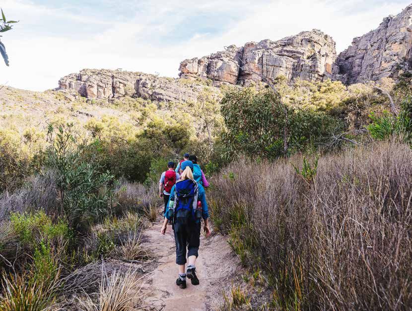
Acknowledgement of Country
Grampians National Park is part of the Gariwerd Aboriginal cultural landscape, which spans
the ancestral lands of the Djab Wurrung and Jadawadjali Peoples.

Parks Victoria respects Traditional Owners’ deep and continuing connection to these lands
and waters and we recognise their ongoing role in caring for Country.

Parks Victoria is working with the Traditional Owners of Gariwerd through the Barengi Gadjin
Land Council Aboriginal Corporation, Eastern Maar Aboriginal Corporation and Gunditj
Mirring Traditional Owners Aboriginal Corporation to protect and manage the landscape.

As of July 2020, Parks Victoria will manage Brambuk: The National Park and Cultural Centre
(Brambuk) in collaboration with these Traditional Owner corporations, and it will become
a significant trail head for the Grampians Peaks Trail.

Front cover: Mt Stapylton, Grampians National Park

Authorised and published by Parks Victoria
L10, 535 Bourke Street, Melbourne VIC 3000
ABN: 95 337 637 697
parks.vic.gov.au

Copyright © Parks Victoria 2020

2
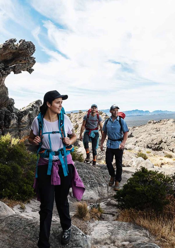
Grampians Peaks Trail
World class long distance walking trail
The Grampians National Park is a major Australian attraction and the third most visited park in the state with over
1.3 million visitors per year. To showcase the beauty and majesty of the park, Parks Victoria is developing the Grampians
Peaks Trail (GPT).

The GPT will traverse the length of the Grampians National Park along the Gariwerd mountain range. From Mt Zero
in the north through to Dunkeld in the south, when complete in December 2020, the GPT will offer mountain vistas,
peaks, spectacular scenery, dazzling wildflower displays and diverse wildlife.

Positioned as the longest of the four long distance walks in the Walk Victoria’s Icon portfolio, the GPT is a $33m initiative
funded by State and Federal governments for 100km of new tracks, 60km of improved tracks, 11 hike-in campgrounds,
a group camp and trail heads along its spine.

In addition, as a part of GPT optimisation, Parks Victoria is creating two (2) signature hike-in campgrounds that will
feature hut accommodation and large tent pads, to further support a diversified walker market.

Parks Victoria Licensed Tour Operators (LTOs) offer invaluable visitor experiences across the state that connect people
and parks and contribute to local visitor economies.

This prospectus outlines LTO opportunities associated with the GPT and details to aid in tour and itinerary development.
In particular, the opportunity for exclusive bookings of on-park hut accommodation by LTOs.

                                                                                      160   kilometres
                                                                                      13    days walk
                                                                                      12    overnight hike-in campgrounds
                                                                                      20+   GPT walker trail options
                                                                                      4     grade walk
                                                                                      2     signature hike-in campgrounds

             35,000                           975                             90                       $6.39m
           targeted                       native plant
                                                                      wildlife species             local benefit p.a.
      walking visitors p.a.                 species

                                                                                 GPT Licensed Tour Operator Prospectus      3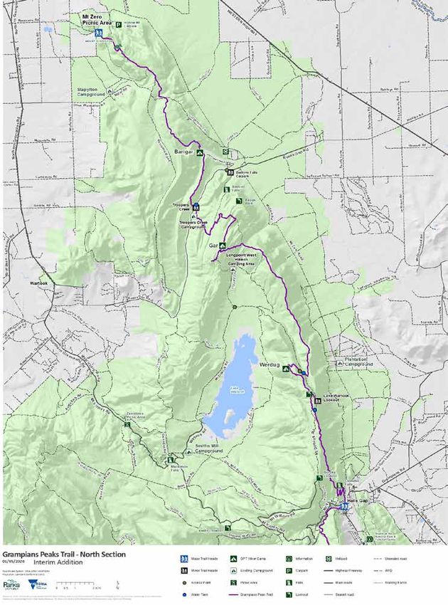
Grampians Peaks Trail
To Horsham
15 km
Mt Zero Picnic Area
Mt Stapylton
Dadswells Glenorchy
Bridge
N1
Roses
HE
W
Barigar Gap RD ES
NT
P
ES GA T ER
Y
ROS N
Troopers Creek
N2 HW
To St Arnaud
60 km
Y
Gar
M T
HW
Y
Lake
Mt Difficult Lonsdale
Wartook
D I
N3
Brimpaen Valley
F F
I C
Stawell
U L
Werdug
T
Lake
Wartook
R A N
N4 RD
NS
G E
PI A To Ararat
Cherrypool AM 16km
Chatauqua GR
Lake Fyans
(Djarabul) Peak
Halls Gap
Black Ran ge
Brambuk the
State Park National Park
Pinnacle C1 & Cultural Centre
Stony Creek
Group Camp SI Bugiga
LV
Mt Rosea ER BA
N
Lake
Bellfield
Pomonal
D RD
C2
Barri Yalug
Glenisla Moora Moora
Reservoir
M Redman
Bluff
T W
Rocklands
Reservoir
IL L
IA M R C3
D
G ra mp ia ns Mt
William
N a tio na l Pa rk Duwul Moyston
G E
To Ararat
5 km
R A N
Major Mitchell
Durd Plateau
Durd C4
RD
R A
RIST
C5
S E R
Mirranatwa
TO U
R A N G E
Yarram
HWY
RD
Y
LE
L
VA
YARRAM
A
A
RI
GAP
O
S1
CT
V I C T O R I
RD Lake
Wannon
VI
Buninjon
Lake
Y Muirhead
NT
HE
RD Griffin Trail Sections Distance *
segment (km)
INT
PO N1 Mt Zero to Barigar 12.9
NS
Cavendish
PIA
S2 N2 Barigar to Gar Willaura 11.3
AM
Victoria N3 Gar to Werdug 14
GR
Valley N4 Werdug to Halls Gap 13
IA
Bryan
Djardji-djawara C1 Halls Gap to Bugiga 8.6
TOR
Swamp
C2 Bugiga to Barri Yalug 14.2
VIC
Signal Peak
C3 Barri Yalug to Duwul 12
S3 C4 Duwul to Durd Durd 15.6
Mt Abrupt C5 Durd Durd to Yarram 12.5
S1 Yarram to Wannon 11.9
S4 Mud-Dadjug S2 Wannon to Djardji-djawara 15.4
Mt Sturgeon S3 Djardji-djawara
GLENELG to Mud-Dadjug 10.4
S4 Mud-Dadjug to Dunkeld 12.1
To Hamilton
Dunkeld Total 163.9
10 km To Hamilton
25 km * Distances are approximate until track construction is complete
Grampians Peaks Trail - Project Overview (As at July 2020)
Hiker camps Highway 4WD track GPT Grampians National Park
Major trail heads Main road Seasonal closure Other park/reserve
Minor trail heads Sealed road Management vehicle Waterbody V I CT ORI A
only
Mountain/peak Unsealed road Wetland/Swamp
www.parks.vic.gov.au
Disclaimer: Parks Victoria does not guarantee that this data is without flaw of any
kind and therefore disclaims all liability which may arise from you relying on this information.
Cartography by Parks Victoria April 2020. 0 10 Km
4
GPT Sections
The Grampians Peaks Trail project is made up of 13 key sections, classified into the Northern (N), Central (C)
and Southern (S) Grampians. LTO’s have the ability to combine any or all of them. With multiple entry and exit
points, LTO’s will also have the ability to access the trail via multiple major and minor trail heads.
NORTHERN GRAMPIANS
N1: Mt Zero to Barigar 12.9 km. Medium with some hard climbs
From the far north of the park, hike through a rock amphitheatre to the summit of Mt Stapylton.
Here the trail overlooks the Wimmera Plains, follows rocky escarpments and descends into Barigar.
N2: Barigar to Gar 11.3km. Medium - hard
Enjoy a gentle walk along low ridge lines with views to Briggs Bluff and Mt Difficult, crossing Roses
Gap Road, then hike an ascending track past seasonal cascading waterfalls before a hard climb to
Gar; perched below Mt Difficult.
N3: Gar to Werdug 14km. Medium with some hard pinches
Hike up and down the Mt Difficult eastern escarpment, leading to great views to the east of
the Pyrenees and the Black Range, and to the west of the Wartook basin, finishing at Werdug,
overlooking Lake Wartook.
N4: Werdug to Halls Gap 13km. Medium
This leg involves; weaving through rocky outcrops, a spectacular view from the Lake Wartook
lookout and descending below Boroka lookout to Chatauqua Peak into Halls Gap.
CENTRAL GRAMPIANS
C1: Halls Gap to Bugiga 8.6km. Medium - hard
A good climb from Halls Gap via Venus Baths, Elephant Hide, the Grand Canyon, and the popular
Pinnacle lookout, through unique geological formations past Lake View to Bugiga.
C2: Bugiga to Barri Yalug 14.2km. Medium-hard
Leaving Bugiga the trail weaves to the summit of Mt Rosea, via the Gate of the East Wind, descends
through tall forest past Borough Huts campground, crosses Grampians Road into Barri Yalug.
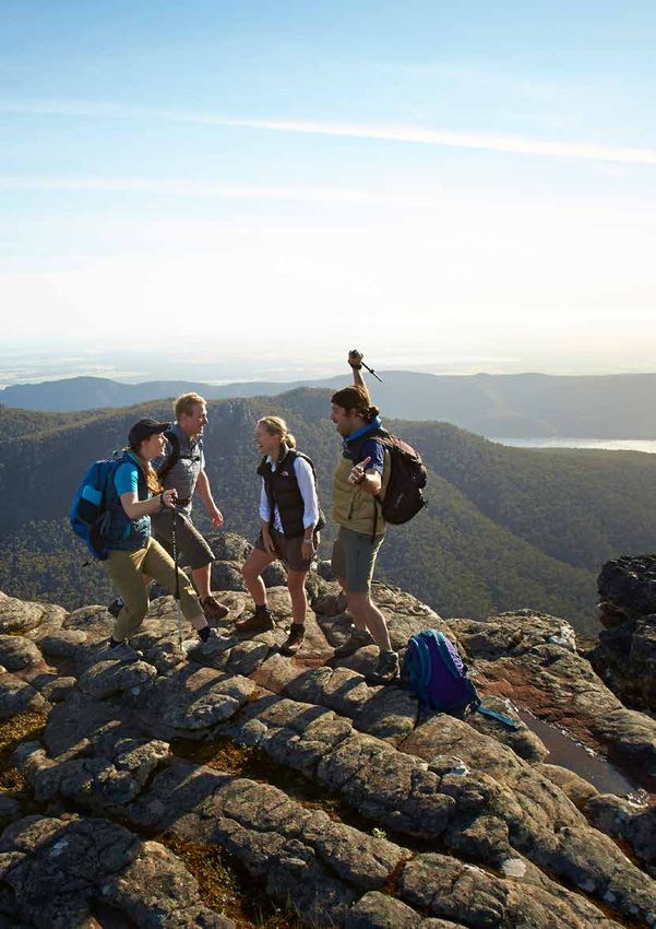
C3: Barri Yalug to Duwul 12km. Hard
Ascend through rocky terraces, over the Seven Dials, onto Redman Bluff offering 360 degree views,
followed by big descents and ascents to the Duwul, in the shadow of Mt William.
C4: Duwul to Durd Durd 15.6km. Medium with some hard spots
Traverse the Mt William range. Firstly with an ascent to Mt William (highest peak in the Park),
followed by a steep section to Boundary Gap, across the magnificent Major Mitchell Plateau,
and into Durd Durd.
C5: Durd Durd to Yarram 12.5km. Medium - hard
A long descent to Jimmy Creek Road, climbing back up a challenging ridge line with views to the
east and into Yarram. This is the most remote part of the GPT, with sunset views.
SOUTHERN GRAMPIANS
S1: Yarrum to Wannon 11.9km. Medium
The trail descends through the Hidden Valley, crosses Yarram Gap Road, follows a ridge line with
views west of the Sierra Range, leading to Wannon nestled in a grassy valley.
S2: Wannon to Djardji-djawara 15.4km. Medium
A short flat section through the Wannon Fan, crossing Grampians Road, a gentle ascent, an
undulating track along the Sierra Range and into Djardji-djawara.
S3: Djardji-djawara to Mud-Dadjug 10.4km. Hard
Shorter than others this section has several steep ascents / descents, crossing Signal Peak and Mt
Abrupt, leading to the dramatic Mud-Dadjug, perched on a high plateau below Mt Abrupt.
S4: Mud-Dadjug to Dunkeld 12.1km. Medium - hard
Descends from Mt Abrupt, crosses the Piccaninny, has a strong climb up and down to Mt Sturgeon,
and meanders through red gums along the Wannon River, finishing in Dunkeld.
GPT Licensed Tour Operator Prospectus 5
GPT Walker Experiences
    FULL GPT
      13 days / 12 nights

    DAY WALKS
       Northern Grampians
    * Mt Stapylton
    * Troopers Creek - Mt Difficult

       Central Grampians
    ^ Venus Baths - Pinnacle - Sundial Carpark
    * Mt Rosea
      Mt Rosea - Borough Huts

       Southern Grampians
      Mt Abrupt
      Piccaninny - Mt Sturgeon
    ^ Mt Sturgeon - Dunkeld

    SHORTER MULTI-DAY WALKS
      Northern Grampians
      1 night / 2 day Mt Zero - Troopers Creek
      2 night / 3 day Troopers Creek - Halls Gap
      3 night / 4 day Mt Zero - Halls Gap

      Central Grampians
      1 night / 2 day Halls Gap - Mt Rosea carpark
      1 night / 2 day Kalymna - Jimmy Creek
    * 2 night / 3 day Wonderland & Rosea
      2 night / 3 day Mt Rosea - Mt William
      2 night / 3 day Halls Gap - Mt William
      2 night / 3 day Mt William - Jimmy Creek
      3 night / 4 day Mt William - Griffin
    * 3 night / 4 day Major Mitchell Plateau
      4 night / 5 day Halls Gap - Jimmy Creek

      Southern Grampians
      1 night / 2 day Mt Abrupt - Dunkeld
      1 night / 2 day Jimmy Creek - Yarram Gap
      1 night / 2 day Yarram Gap - Griffin
      2 night / 3 day Griffin - Dunkeld
      3 night / 4 day Jimmy Creek - Mt Abrupt
      3 night / 4 day Yarram Gap - Dunkeld
      4 night / 5 day Jimmy Creek - Dunkeld

    * Loop trail / return walk
    ^ Trail Rider all terrain wheelchair access for portion of trail
6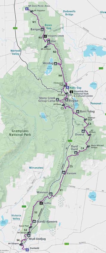
How is the GPT being optimised
                                                                                      and accessible to park users beyond
                                                                                      the fit, 13 day independent walker?

                                                                                      Parks Victoria is expanding GPT
                                                                                      walker experiences to meet
                                                                                      the needs of different visitor
                                                                                      markets, optimising trail and
                                                                                      hike-in campgrounds and off park
                                                                                      servicing.

GPT Product Optimisation
To support a diversified walker market, the Grampians Peaks Trail will target six key user segments. including free
and independent walkers, facilitated walkers, guided walkers, day walkers, the education market and event participants.

1.   Multiple GPT entry and exit point options                 13. Raised camp pads and larger camp pads suitable
2.   6 x major and minor way finding trail heads                   for 3 persons
3.   Alternative campground access routes for servicing,       14. Delineation between walker market spaces in
     while balancing the desire for hiker remoteness               shared use camp grounds
4.   Dedicated group camp                                      15. Covered shelters, including food preparation,
                                                                   dining and storage areas at designated hike-in
                                                                   campgrounds
                                                               16. Hike-in campground spaces for coming
                                                                   together, sharing and interpretation
                                                               17. Hike-in campground designs that offer a view
5.   Development of shorter multi day walks, loop trails           from every ‘room’
     and trail sections accessible by Trail Rider
6.   Walk diversity with different degrees and lengths
     of trail difficulty
7.   Wider trail sections for group access and side by
     side walking
8.   Connections to National Park attractions, visitor         18. Environmentally sensitive hut accommodation
     hubs, activities and off park services                        suitable for groups and families
                                                               19. Utilisation of long lasting trail materials that are
                                                                   sensitive to the environment
                                                               20. Rainwater collection and on trail water tank
                                                                   access
                                                               21. Trail alignment that maximises national park
                                                                   iconic highlights while preserving cultural and
9. Famed Aboriginal heritage connections                           biodiversity sites
10. Development of Brambuk the National Park and
    Cultural Centre (Brambuk) as a significant GPT
    trailhead, in collaboration with Traditional Owners
11. Diverse hike-in campground landscape locations
12. Signature hike-in campgrounds with enhanced
    facilities

                                                                            GPT Licensed Tour Operator Prospectus         7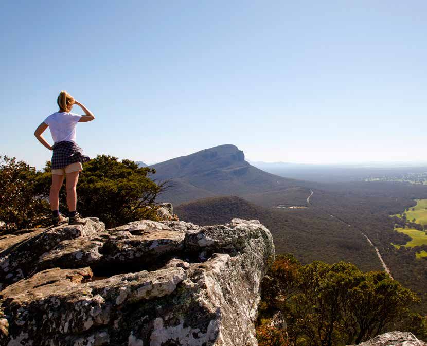
GPT LTO Licensing Opportunities
Parks Victoria has developed a number of multi day walks, circuits and loops trails of varying lengths and degrees
of difficulty. Some of these are featured on page 6. There are opportunities for LTOs to package any of the suggested
walk itineraries under a standard GPT LTO licence.

In addition, two Northern Grampians hike-in campgrounds at Gar and Werdug will feature hiker hut accommodation.
Proposed to open in December 2020, the huts will only be bookable by LTOs. In addition, LTOs will receive preferential
access to large tent pads (with standard tent pads and hike-in campground access available to independent walkers).

    STANDARD                                      STANDARD                                      SIGNATURE
    Grampians NP                                  GPT                                           GPT Northern Peaks
    LTO Licence                                   LTO Licence                                   LTO Licence

    For: Various activities                       For: Bushwalking                               Exclusive LTO access**
    Term: 1,3*,5 & 10 year                        Term: 1,3*,5 & 10 year                         Term: 1,3*, 5 year
    Timelines: Applications open                   1. Full GPT, any multi day                    Huts (only bookable by
    July for 2020 / 2021 licensing                    walks or day walks                         LTOs) and preferential
    season+                                           (excluding Gar & Werdug                    bookings for large tent
    Standard Grampians NP
                                                      hike-in campgrounds)                       pads at Gar and Werdug.‡
    licence.                                       2. Dedicated group camp                       Timelines: Applications
                                                      at Stony Creek ∆                           open from July 2020.
                                                  Timelines: Applications                        Bookings from December
                                                  open from July 2020.                           2020 (date TBC)

                                                  Note: Full GPT opens                           Will be issued as a special
                                                  December 2020                                  condition in a standard
                                                                                                 GPT licence.

 * 3 year licenses only available to compliant LTO’s licensed for three consecutive years
 + Excludes new rock climbing applications in Grampians NP (until the Landscape Management Plan has been completed)
 ∆ Stony Creek group camp ground will be issued as a special condition to a standard GPT licence
 ** 4 x standard tent pads and access to shelter and toilet facilities will be retained for independent walkers
 ‡ Large tent pads not booked by LTOs will become available to independent walkers

8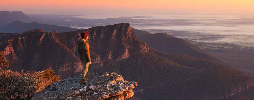
GPT Camp
Facilities
Signature Hike-in Campgrounds are
located at Gar and Werdug and include:
  • large enclosed shelter
  • 2 unisex toilets
  • 4 x standard timber tent pads
  • 5 x large timber tent pads
  • 3 x 4 person huts
  • group gathering area
  • landscape delineations
  • ceremonial fire place (for Traditional
      Owner ceremonies)

Standard Hike-in Campgrounds are
located at Barigar, Bugiga, Djardji-djawara
and Mud-Dadjug and include:
  • large enclosed shelter (Bugiga - open
      shelter)
  • 2 x unisex toilets
  • 12 timber camp pads

Back Country Hike-in Campgrounds are
located at Barri Yulug, Duwul, Durd Durd,
Yarram and Wannon and include:
  • open shelter (Yarrum - large shelter)
  • 1 x unisex toilet
  • 10 camp pads (6 timber)

A dedicated Group Camp is located at
Stony Creek and includes:
  • large enclosed shelter
  • 2 unisex toilets
  • 8 camp pads
  • group gathering area

Further Parks Victoria Group Camps in close
proximity to the GPT are located at Stapylton,
Coppermine, Troopers Creek, East and West
Longpoint, Borough Huts, Jimmy Creek
and Kalymna.

                                                 9
LTO Camp Access
                  Depicted are GPT access points, major
                  and minor trail heads, water tank
                  locations, hike-in campgrounds and
                  other GPT features.
                  1. Barigar. 4WD* via private land
                      (Parks Victoria arranged) 15 min.
                  2. Gar. 4WD* + 1.25 hr walk
                  3. Werdug. 30 min walk
                  4. Bugiga. 2WD + 5 min walk or
                      4WD* 5 min
                  5. Stony Creek. 2WD
                  6. Barri Yalug. 30 min walk
                  7. Duwul. 15 min walk
                  8. Durd Durd – 4WD* 30 min
                  9. Yarram. 1 hr walk
                  10. Wannon. 4WD* 20 min
                  11. Djardji-djawara – 2WD + 15 min
                      walk or 4WD* 5min
                  12. Mud-Dadjug – 45 min walk
                  * Denotes Management Service Vehicle
                  only tracks via secured locked gates. LTO’s
                  may qualify for access to relevant areas
                  **Detailed section maps are also available
                  for Central and Southern Grampians

10
LTO BOOKINGS
Trail fees: covered under the GPT, licence and
use fees
Accommodation: cost per hut and large tent
pad per night TBC.
LTO bookings: Parks Victoria online
accommodation bookings system Park Stay,
Parks Victoria call centre, Brambuk The National
Park and Cultural Centre.
Conditions:
• LTO bookings by hut and large tent pad,
rather than by bed.
• GPT is only bookable one-way (north
to south).
• Maximum 4 persons per hut.
• LTO exclusivity does not apply to the
entire hike-in campground, tent pads for
independent walkers and their access to
toilets and shelter will apply.
• LTO’s will be responsible for cleaning,
rubbish removal and maintaining
access areas.
• Other GPT licence conditions as outlined
in Parks Victoria’s tour operator licence.
GPT LTO opportunity – Northern Peaks
The availability of Gar and Werdug hike-in campgrounds for LTO only bookings provides the flexibility for differentiated
GPT LTO itineraries. A few suggestions are outlined below. Parks Victoria encourages LTO’s to create their own itineraries.
4 day / 3 night
• DAY 1: Hike Mt Zero to Barigar standard hike-in campground (12.9km)
• DAY 2: Hike Barigar to Gar signature hike-in campground (11.3km)
• DAY 3: Hike Gar to Werdug signature hike-in campground (14km)
• DAY 4: Hike Werdug to Halls Gap (13km)
3 day / 2 night
• DAY 1: Hike Troopers Creek to Gar signature hike-in campground (7.5km)
• DAY 2: Hike Gar to Werdug signature hike-in campground (14km)
• DAY 3: Hike Werdug to Halls Gap (13km)
2 day / 1 night
• DAY 1: Hike from Mt Difficult Rd to Werdug signature hike-in campground (1.5km)
• DAY 2: Hike Werdug to Halls Gap (13km)
2 day / 1 night
• DAY 1: Hike Troopers Creek to Gar signature hike-in campground (7.5km)
• DAY 2: Hike to Mt Difficult to Briggs Bluff to Beehive Car Park (12.5km)
GPT Licensed Tour Operator Prospectus 11Signature Hike-in Campground Designs
Grampians Peaks Trail
Each hike-in campground is unique and sympathetic to the surrounding landscape with orientation and amenities carefully
Gar HikerforCamp
designed and located to provide the optimal experience hikers–settling
Site Plan
in for the night.
Raised Timber Tent Pads
Hikers will set up tents on 3.5 x 3.5m timber pads
Raised Timber Tent Pads
Tents on 5 x 5m timber pads
Timber Platform Break-out Space
Toilets
Waste water will be collected
in pods and periodically Ceremonial Fire Place
air-lifted out.
Rain water will be collected
from shelter roof into a
tank.
Communal Shelter
Where hikers will be able to sit and relax,
prepare food and enjoy the views, all while The Trail
being protect from the elements. Stone Step Pathway
Rain water will be collected from shelter
roof into a tank and available for hikers to
treat and drink.
Steel Boardwalks
Above: Gar hike-in campground design Camp Huts
Produced by GPT Project Team – 1 May 2020
Above: Artist’s rendition of hike-in campground and shelter
Above: Werdug hike-in campground design
12Gar and Werdug Hike-in Campgrounds
Camp features
Hike-in Campground
• 2 unisex toilets
• 4 standard timber tent pads (3.5m x 3.5m)
• Communal shelter with kitchen bench, dining tables, seating, storage, phone charging points and water tank
• Landscaping to delineate campground zones
• Steel boardwalks and stone step paths
LTO access only
• 3 huts with 4 beds each
• 5 large (2-3 person) raised timber tent pads (5m x 5m) for larger tents (LTO preferential access)
• Ceremonial fire place (for Traditional Owner ceremonies only)
• Timber platform break out / interpretation space
• Potential licence privileges on management service vehicle only tracks for closer hike-in campground service access
Above: Artist’s rendition of hike-in campground huts
GPT Licensed Tour Operator Prospectus 13Next Steps
Parks Victoria invites you to apply for a tour operator Parks Victoria plans to organise site visits to Gar and
licence to conduct bushwalking activities on the Werdug in late 2020 for those licensed to book the hike-in
Grampians Peaks Trail. More specifically, to submit an campgrounds in the 2020/2021 season. Site visits may also
application to be licensed to book hut accommodation include a Traditional Owner induction program.
and large tent pads at Gar and Werdug hike-in
campgrounds. Further information will be available to tour operators
as the Grampians Peaks Trail progresses.
The 2020/2021 licensing season opens July 2020.
Gar and Werdug hike-in campgrounds will be bookable GPT information sessions will be scheduled in Spring
by December 2020. 2020. Tour operators interested in becoming licensed
to use Parks Victoria’s public land will be invited to attend.
CONTACT:
Tour operator licencing: parks.vic.gov.au
GPT LTO packaging: Tourism Partnerships 03 8427 2403
GPT status, maps, plans and designs:
parks.vic.gov.au/projects/grampians-peaks-trail
14Disclaimer
This GPT LTO prospectus is intended to provide Parks Victoria does not take responsibility for Grampians
background information. Peaks Trail or hike-in campground impediments such as
access or approvals.
Parks Victoria does not give any warranty, expressed
or implied, as to the accuracy or completeness of All information given to an applicant by Parks Victoria or
information contained in this prospectus or which may its respective officers or agents will be given on an ‘all
be provided in association with it, before this date, or in care and no responsibility’ basis.
future by Parks Victoria, its officers or agents.
Applicants acknowledge and agree that a Licensed Tour
Parks Victoria does not accept any responsibility to any Operator application does not create a process contract.
applicant or third party under the law of contract, tort
By submitting an application, the applicant agrees,
or otherwise for any loss or damage which may arise
without qualifications, to have acknowledged and
from anything contained in this prospectus, any matter
accepted this disclaimer.
deemed to form part of it, or any information supplied
on behalf of Parks Victoria.You can also read