LIGHTNING JUMP ALGORITHM AND RELATION TO THUNDERSTORM CELL TRACKING, GLM PROXY AND OTHER METEOROLOGICAL MEASUREMENTS
←
→
Page content transcription
If your browser does not render page correctly, please read the page content below
https://ntrs.nasa.gov/search.jsp?R=20130000644 2018-10-21T08:17:17+00:00Z

LIGHTNING JUMP ALGORITHM AND
RELATION TO THUNDERSTORM CELL
TRACKING, GLM PROXY AND
OTHER METEOROLOGICAL MEASUREMENTS
      Chris Schultz1,2, Larry Carey1, Dan Cecil2, Monte
       Bateman3, Geoffrey Stano4, Steve Goodman5

  1 Department of Atmospheric Science, UAHuntsville
  2 NASA MSFC
  3 USRA/NASA MSFC
  4 ENSCO/NASA SPoRT
  5 NOAA NESDIS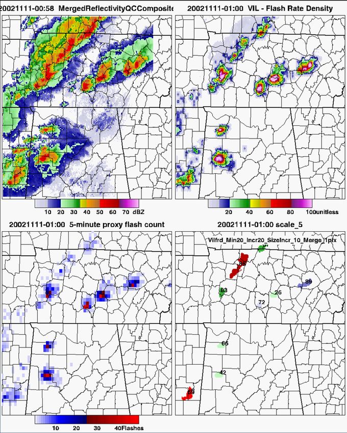
Goal of LJA Project
Objective ‐ To refine, adapt and demonstrate
the LJA for transition to GOES‐R GLM
(Geostationary Lightning Mapper) readiness
and to establish a path to operations
Ongoing work – reducing risk in GLM lightning
proxy, cell tracking, LJA algorithm automation,
and data fusion (e.g., radar + lightning).
The Lightning Jump Concept
Several studies in the past
have correlated increases
in total flash rates within
a storm to severe weather
occurrence , e.g.,
Goodman et al. 1988
Williams et al. 1989
Williams et al. 1999
Schultz et al. (2009)
Gatlin and Goodman (2010)
The correlation is
between the following
Updraft strength and
modulation of
electrification
Updraft strength and ability
to produce severe and
hazardous weather.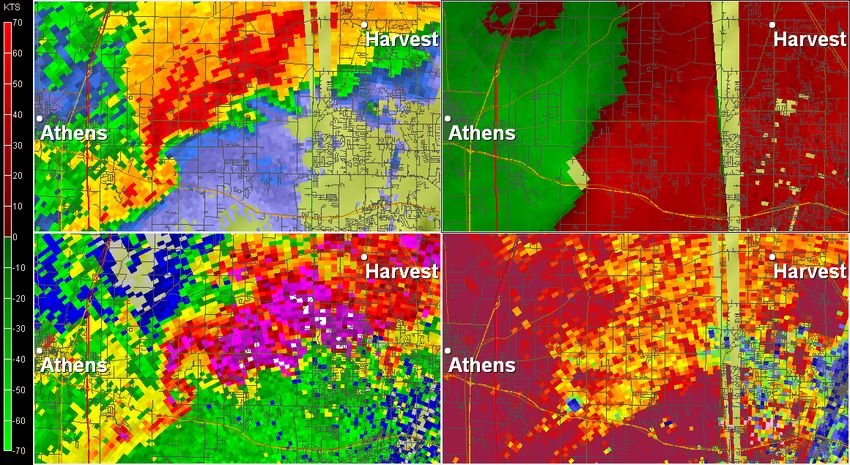
Recent LJA Work Schultz et al. (2011) recently demonstrated the feasibility of the 2 lightning jump algorithm (LJA) on a large sample of 711 thunderstorms (severe and non‐severe) from across the country. POD 79%, FAR 36%, CSI 55%, HSS 0.71. Avg. Lead time 20.65 minutes +/‐ 15.05 minutes Schultz et al. (2009, 2011) used native LMA total lightning and TITAN cell tracking, with manual changes when needed Storm splits, mergers Cells change shape/size
Real Time Situation Awareness
Utility
The LJA Can: The LJA Cannot:
Indicate when an Predict severe weather
updraft is strengthening potential in every severe
or weakening on shorter storm environment.
timescales than current Discern severe weather
radar and satellite types
Identify when severe or i.e., a certain jump does
hazardous weather not mean there will be a
potential has increased certain type of severe
weather
“Tip the scales” on
Issue specific types of
whether or not to issue a
severe warnings
severe warning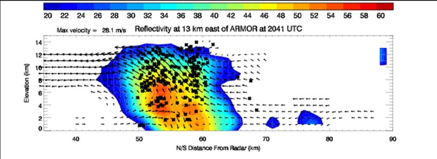
March 2, 2012
“...MS/AL/GA LATE THIS AFTERNOON
INTO TONIGHT... THE MOIST/UNSTABLE
WARM SECTOR IS ALREADY
ESTABLISHED ACROSS THE GULF COAST
STATES THIS MORNING. THIS AREA WILL
REMAIN A LITTLE S OF THE STRONGEST
DEEP‐LAYER FLOW...AND THE
STRONGEST LLJ CORE WILL DEVELOP
NEWD TO THE OH VALLEY IN
CONJUNCTION WITH THE UPPER JET
STREAK AND SURFACE CYCLONE.
STILL...INSTABILITY AND VERTICAL
SHEAR WILL BE FAVORABLE FOR
SUPERCELLS WITHIN IN ONE OR MORE
BANDS OF CONVECTION ALONG AND
AHEAD OF THE COLD FRONT BEGINNING
LATER THIS AFTERNOON AND
CONTINUING INTO TONIGHT. RISKS WILL Main threat for AL targeted for the
INCLUDE A FEW afternoon in association with trailing
TORNADOES...DAMAGING WINDS...AND
LARGE HAIL THROUGH TONIGHT.” front
SPC 13Z outlook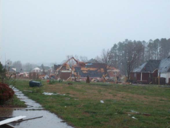
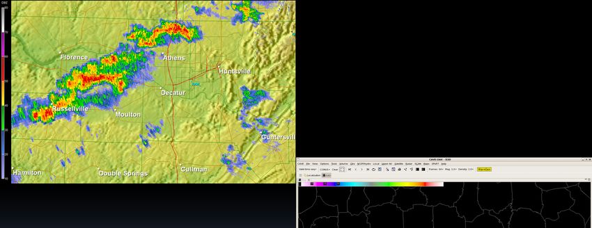
1432 – 1452 UTC
KHTX ( every 5 minutes )

                           NALMA FED ( every 2 minutes )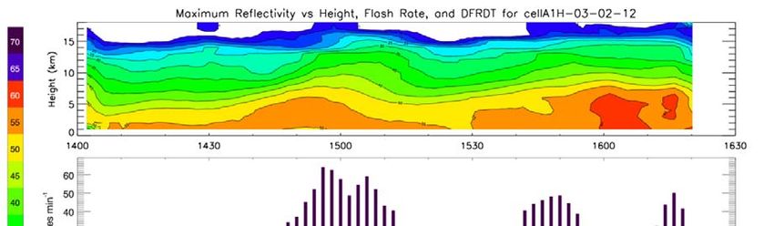
1451 UTC – NWS Huntsville Issues Warning
Lightning jump        ‐ Forecaster notes increase in lightning
                      ‐ First reports of severe weather 1520 UTC

“tips the scale”      ‐ Debris signature observed on ARMOR at 1513 UTC
                      ‐ Lead time on event 19 minutes (touchdown 1510)

                   ARMOR 1517 UTC 3/2/2012

    Zh               Vr

    ZDR              CC

                                        TDS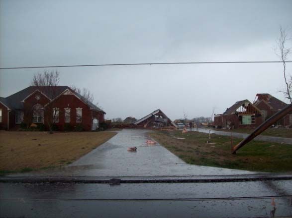
Lightning
Jump,
lightning
Flash
rates, and Rate
comparisons
to radar DFRDT
derived TORNADO
products,
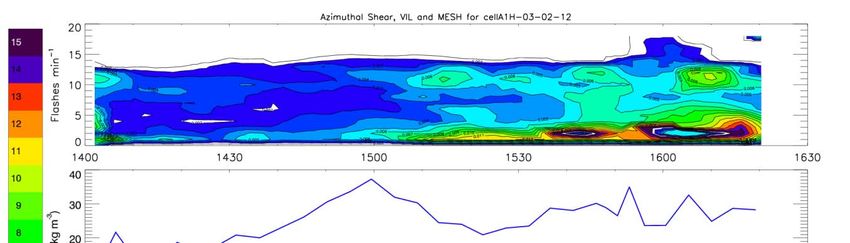
March 2, 2012 Azimuthal Shear
Top – Reflectivity
2 down – total flash rate
Middle – DFRDT, LJ VIL
4 down – VIL trend
Bottom – MESH trend
MESH
More Feedback from Users WFO Nashville: "The LMA often helps 'tip the scales' towards warning an issue.” WFO Huntsville: "This was a particularly good case (March 2, 2012), in which the LMA data helped the warning forecaster to realize that a storm of interest was likely to undergo rapid strengthening, and that a warning was necessary." WFO Morristown: “…based on the big jump in source density values and the slight jump in POSH (and the favorable storm environment), I decided to issue a SVR.” 20 minutes after warning issued, damaging winds occurred near Jasper, TN (April 24, 2010) http://nasasport.wordpress.com/2010/04/27/use‐of‐lma‐data‐tips‐the‐scales‐toward‐a‐warning/ WFO Huntsville: "I believe the density rates were the primary factor in holding off on a warning." Spring Program Participant: "Not necessarily going to be the main warning product, but it will be a good confirmation tool. If I had paid more attention and been more aware I could have issued my tornado warning one scan earlier." (24 May 2008 case event)
Development is more than
   just an algorithm

        Thunderstorm
          Tracking

 LJA             GLM Lightning Proxy
Transition from LMA to GLM
Proxy
Observations from LMA
≠ GLM
Different instrument
Different frequency
Different part of flash
Must transition product
from LMA to GLM proxy
data stream
First step, using current
GLM ProxyTransition LJA to GLM Proxy
Compared 1‐minute
flash rates in LMA and
GLM for 131 storms
20+ sources per flash
threshold
GLM Proxy flash count is
~88% of the LMA flash
count
Correlation in the trends
are strong
R= 0.9
GLM flash rates have a
ceiling at ~100 flashes
per minuteTransition to GLM Proxy:
GLM Proxy vs. LMA trends
2011‐04‐27 Cell A1H 2012‐03‐02 Cell A1H 2012‐03‐02 Cell B1H
Lightning trends are still present in the GLM proxy data.
Magnitudes of lightning flash rates and jumps are not as pronounced
in GLM proxy as LMA
But the standard deviation (2) approach is still robustFields Used for Cell Tracking 2002‐11‐11 00:58 UTC
Flct5: 5-minute GLM proxy flash count,
updated every minute
VIL: Vertically Integrated Liquid (radar)
VILFRD: VIL combined with 5-minute Flash
Rate Density
VILFRD = 100 * ( ((VIL/45) ≤ 1) +
(sqrt(Flct5/45) ≤ 1) )
Track values where VILFRD ≥ 20, using
increments of 20, with anything over 100 set
to 100.
Tracker (WDSSII w2segmotionll) builds cells
until a minimum size threshold is met.
Several sizes tested; we use ~200 km2 for
large storms, ~80 km2 for smaller storms.
First see if values exceeding 100 cover large
enough area (e.g., cells 26, 42, 72, 83)
If not, include values exceeding 80 (e.g., cells 66, 89) Tra
If not, include values exceeding 60 (e.g., cell 66, 89), 40
(e.g., cell 69), or 20 (e.g., cell 36).Cell Tracking Left: GLM Proxy Flash Count Middle: Combined VIL‐Flash Density Field Right: Tracked Features Tracking uses WDSSII w2segmotionll, with maximum overlap approach for associating cells from one time step to the next. Cells are projected forward from time t to t+1 (1-minute increments, so projected motion has very little effect) If an observed cell at t+1 matches a cell location projected forward from t, within (5 km) or (1 x Size of Cell), then it is associated with that previously identified cell’s history. If a cell disappears in one time step, it cannot re-appear later. Outside WDSSII, “broken tracks” are objectively merged. If WDSSII has a new cell begin at t+1 within 20 km of where a previous cell track ended at time t, those cell histories are tied together. (This last step is not reflected in animation, but is in flash rate time series .)
LMA vs. GLM Proxy Flash Rate and Jumps
Cell 4 / Cell D 11‐11‐02

GLM Jump:     LMA Jump:    Tornado:   Hail:   Wind:
The Next Step: Understanding the Physics Behind the Jump
Key points this analysis will address:                      KHTX‐ARMOR dual‐Doppler analysis July 19, 2006

1) What physically is going on in the cloud
   when there is a jump in lightning?
    ‐ Updraft variations, Ice fluxes
2) How do these processes fit in with severe
   storm conceptual models?
3) What would this information provide an
   end user?
   ‐ Relate LJA to radar observations, like changes
   in reflectivity, MESH, VIL, etc. based multi‐
   Doppler derived physical relationships

                                                      Time height of reflectivity (top) flash rate w/ lightning jumps (red
                                                      asterisks; middle) and VIL (blue; bottom) and MESH (green; bottom)
         Adapted from Deierling et al. 2008, JGR
Summary of Ongoing Work
Refining and developing GLM lightning proxy database
Transformed VHF‐based NA‐LMA to optical lightning proxy using
LIS and statistical‐physical methods
Developed representative proxy lightning (e.g., GLM resolution,
8 km) for 37 events (100’s of cells) from 2002‐2010 over NA‐LMA.
Turn‐key for new cases, as needed.
Improving multi‐sensor (GLM proxy, radar) cell
(object)‐oriented tracking
Optimized current WDSS‐II/K‐means cell tracking algorithm to
reduce tracking ambiguity for LJA
Developing LJA as an automated objective system
Began adaptation of LJA (rules, thresholds) to GLM proxy and
multi‐sensor object tracking improvements
Investigated environmental controls on LJA for identification and
mitigation of known LJA biases during low topped convectionSummary of Ongoing Work
Studying fusion of LJA with radar data and products
Reflectivity‐based, dual‐Doppler, dual‐polarization
For operational use and solidifying the LJA conceptual model
Exploring use of LJA and LJA/radar in forecasting
process and operational situational awareness
User interactions and feedback within NASA SPoRT and local
NWS officesYou can also read