MAPPING FOR RIGHTS: PUTTING RAINFOREST COMMUNITIES ON THE MAP - BRIEFING OCTOBER 2018
←
→
Page content transcription
If your browser does not render page correctly, please read the page content below

MAPPING FOR RIGHTS:
  PUTTING RAINFOREST
  COMMUNITIES ON
  THE MAP

BRIEFING
OCTOBER 2018
1. SUMMARY
MappingforRights, an initiative of RFUK and civil society organisations in the Congo Basin,
aims literally to put forest communities on the map. Since its launch in 2011 it has supported
more than a thousand communities to map and share highly detailed geographical
information about their lands and resources so that decisions on forests do not neglect those
who depend on them most.

This series of short information briefs looks at some of the community maps in more detail
and explores the wider implications for various forest policy processes and programmes
underway in the region. It covers community forestry, conservation, industrial logging,
agribusiness expansion, participatory land use planning and REDD+. In this introductory
briefing, we address the root causes land-based conflict in Central African forests, how
MappingForRights aims to help tackle these and why such initiatives are essential to
sustainable and equitable forest management.

2. BACKGROUND TO FORESTS AND LAND RIGHTS IN THE
CONGO BASIN
With virtually all land in the Congo Basin countries either under state ownership (DRC,
CAR) or custody (Congo, Cameroon, Gabon), forest communities are largely absent from
official government geographical data. This has led to a situation whereby thousands of
communities have seen their traditional lands handed out for extractive industries, for
biodiversity conservation and increasingly for commercial agriculture. Such policies have
essentially left them as either squatters on their own lands or entirely landless, but have not
brought about the expected wealth creation or environmental benefits in forest areas.

In recent years, there has been a growing                    However, in practice, the goal of turning paper
acknowledgement that recognition of forest peoples’          policies into tangible change on the ground has so
rights and role in the management of forests is              far proved elusive. Deep-rooted resistance to rights-
essential to avoid conflict and ensure long-term             based approaches to forest management from
sustainability. Internationally accepted norms - such        business interests, conservationists and high-level
as on community land rights, human rights, free,             officials, weak government institutions to monitor
prior and informed consent (FPIC), and others -              and enforce laws as well as perceived high costs of
have become increasingly evident in the policies             documenting customary rights and forest uses at
of international donors, the large conservation              scale mean that most decisions on forests continue
agencies and national ministries in charge of forests        to be made in ignorance of communities that live
in recent years.                                             and depend on them.

2 | Putting Rainforest Communities on the Map October 2018
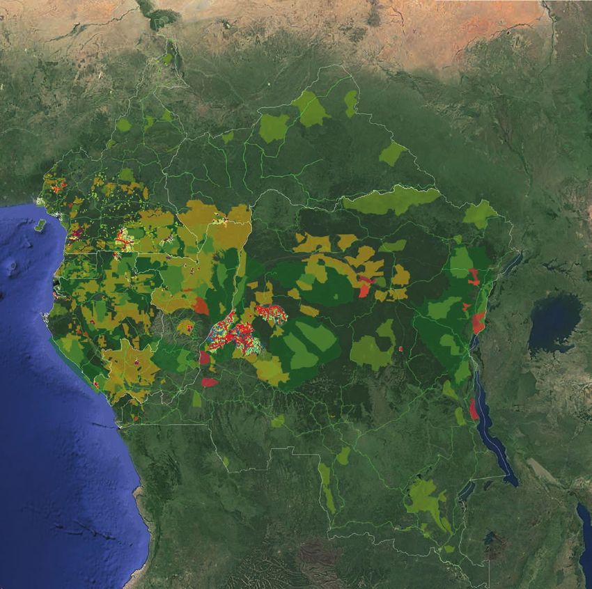
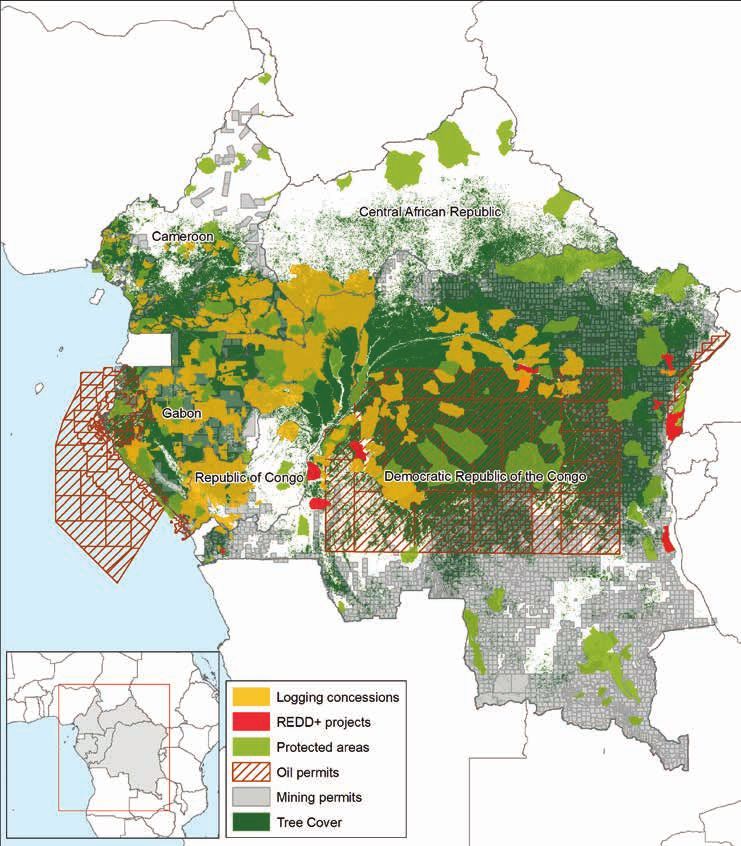
MAP 1 - LAND ALLOCATIONS IN THE CONGO BASIN

Large-scale allocations for commercial logging, the extractive industries and strict nature conservation have generally
not delivered the expected economic, social and environmental benefits in forest areas. Their overlap with areas under
customary ownership has led to widespread land and resource-related conflict in the region and a growing realisation
among policy makers that new approaches to land and forest management are needed. Source: MappingForRights, WRI

                                                                                              www.rainforestfoundationuk.org | 3
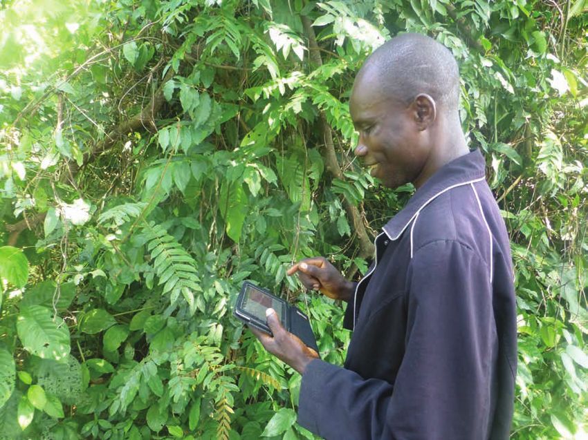
3. MAPPINGFORRIGHTS – PUTTING COMMUNITIES
ON THE MAP
MappingForRights aims to help change this by both simplifying the process of community
mapping of forests and by making the data collected about their presence, claims and use of
these areas easily accessible to decision-makers.

At the village level, communities are supported                 These advances have made the participatory
through RFUK’s MappingForRights programme to                    mapping process much more responsive to local
map their lands according to a specific methodology             needs but have also broken down costs to such an
to ensure effective participation in the mapping                extent that it is now possible to map community use
process developed on the back of more than                      of forests for less than a US$1 per hectare. Since
15 years’ experience in this field. Mappers are                 2013 alone, the programme has supported nearly
equipped with easy-to-use, low-cost technologies                1,000 communities to produce highly accurate maps
which enable them to record geographical features               of their lands and resources covering more than five
they themselves define as important such as clan                million hectares - an area one quarter the size of
tenure boundaries, fishing areas and sacred sites.              Great Britain.
The mobilisation of mobile mapping support units
(teams of mapping facilitators and GIS technicians
from local civil society organisations) support the
process, by conducting technical GIS work inside
the villages alongside local people rather than in a
remote town or city.

The use of icon-based applications allows even those who can’t read or write to participate, producing maps that more
accurately reflect the whole community’s interests.

4 | Putting Rainforest Communities on the Map October 2018
MAP 2 - EXAMPLE OF PARTICIPATORY COMMUNITY MAPPING IN DRC

This map shows how clan-based customary rights run contiguously across the area mapped, and are generally very
well defined and understood locally, even if they are not yet formally recognised. This provides an alternative vision
of forest management to the industrial logging and strict nature conservation paradigm of recent decades. Source:
MappingForRights.

                                                                  Once validated by the community and its
                                                                  neighbours, the community map is then made
                                                                  available to authorized users via an online
                                                                  interactive database. The results provide important
                                                                  insights into customary claims and forest usages
                                                                  that are likely to extend across the entire Congo
                                                                  Basin region, and also show where conflict may
                                                                  be occurring with other land users such as logging
                                                                  concessions, REDD+ projects and protected areas.
                                                                  Not only does this work challenge long-held
                                                                  assumptions that these forests are mostly empty
                                                                  wildernesses – and therefore available for resource
                                                                  extraction and strict nature conservation – but it
                                                                  also has profound implications for the governance
                                                                  of forests.

Using a participatory approach can bring different
segments of the community together and helps capture a
more accurate and complete view of the community’s land
and resource use.

                                                                                                 www.rainforestfoundationuk.org | 5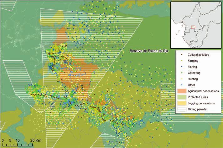
MAP 3 - EXAMPLE OF CONFLICTING LAND USE IN CAMEROON

This map illustrates overlapping land use in southern Cameroon. It shows resources used by local communities as compared
to other land designations, such as logging concessions, palm oil plantations and a wildlife reserve in Dja et Lobo. Such
overlapping land uses are common throughout the Congo Basin and illustrate the need for reliable data and effective land-use
planning.

In this series of short information briefs we will take a closer look at the data collected so far in the
MappingForRights initiative – exploring what this means for various reform processes and programmes in the
region; what it says about where existing laws and policies protecting communities may not have been applied
or need reform; and also how these kind of tools and approaches can be harnessed to promote more equitable
and sustainable use of forests in the future. Issues that are explored include:

REDD+ and Mai Ndombe. How extensive forest                        arrangements as well as for carrying out due
tenure and resource mapping by local communities                  diligence and consent processes for proposed
in Mai Ndombe province has major implications for                 protected areas or to serve as a basis for more
DRC’s flagship jurisdictional REDD+ programme,                    progressive models such as indigenous and
especially in terms of land and carbon rights, land               community conserved areas (ICCA).
management, and distribution of benefits from
anticipated emissions reductions activities.                      Community forests. There is growing consensus
                                                                  on the social and environmental benefits of
Protected areas. How community maps reveal deep                   community based forest management. However,
flaws in the treatment of land and resource rights                too many community forest models fail because
in protected areas’ creation and management,                      they are not well adapted to local contexts. In DRC,
contributing to highly conflictual relations between              detailed mapping of customary tenure and forest
people and parks in many areas. This particular                   management systems is providing a logical starting
brief will show how community mapping should                      point for some of the first community forest pilots in
be incorporated into existing management                          the country, with some promising early signs.

6 | Putting Rainforest Communities on the Map October 2018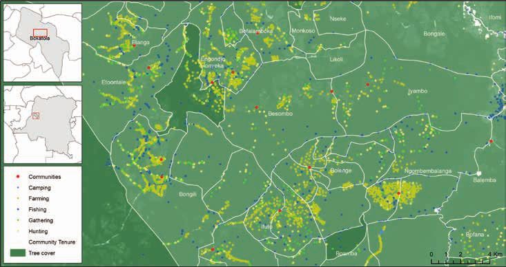
Participatory land-use planning. While there is          Agribusiness expansion. The expansion of
general agreement on the need for participatory          commercial agriculture in the Congo Basin poses
land-use planning in forest areas of the Congo           risks to both forests and people. There have been
Basin, there is much less so on how to actually          various palm oil suitability mapping initiatives
do this in practice. This info brief explores how        aiming to divert agribusiness away from forests,
community mapping is feeding into innovative land-       but far less attention has been paid to the potential
use planning, and captures some of the key lessons       social impacts. Community mapping in Cameroon
from pilot initiatives in south-west Cameroon and        and elsewhere shows how such impacts are already
Maniema and Equateur provinces, DRC.                     starting to be felt, and highlights the need for more
                                                         robust responses to these threats.
DRC logging moratorium. Community maps
prepared in different parts of DRC show that
any process to consider a potential lifting of the
country’s national logging moratorium must first
include thorough documentation and clarification of
customary rights in forests in order to avoid future
conflict in these areas.

   Important note: The absence of community presence, tenure or livelihoods in some of the maps
   displayed in this series of MappingForRights information briefs does not indicate that such presence
   or activities do not exist in that area. Due to limitations of resources, RFUK’s mapping work has only
   taken place in selected areas, so the resulting maps should be taken as an indication where community
   activities occur, not where they do not occur.

                                                                                    www.rainforestfoundationuk.org | 7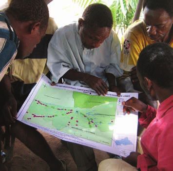
SUPPORTED BY:
This briefing was funded by UK aid from the UK government.
The views expressed do not necessarily reflect the UK
government’s official policies.

The Rainforest Foundation UK would also like to thank the
Anthony Rae Foundation for its generous support.

PARTNERED BY:
The community mapping data featured in this briefing was
collected as part of RFUK’s Mapping and Forest Governance
programme (2012 - 2017) with the support of:

Some data for Cameroon was collected by Le Centre
pour le Développement et l’Environnement (CED).
Data for DRC was collected with support from Réseau
Ressources Naturelles (RRN).

2-4 The Atelier, The Old Dairy Court,
17 Crouch Hill, London, N4 4AP,
United Kingdom
+44 (0) 20 7485 0193
info@rainforestuk.org

Rainforestfoundationuk.org                                        Printed on 100% post-consumer waste
twitter.com/RFUK – @RFUK                                          recycled paper

Registered Charity No. 1138287 | Registered Company No. 7391285
You can also read