Mapping the First World War Forgotten Material Heritage: A Multi-proxy and GIS-based Proposal for the Trentino Alps - RiuNet
←
→
Page content transcription
If your browser does not render page correctly, please read the page content below
Defensive Architecture of the Mediterranean / Vol XI / Navarro Palazón, García-Pulido (eds.)
© 2020: UGR ǀ UPV ǀ PAG
DOI: https://dx.doi.org/10.4995/FORTMED2020.2020.11397
Mapping the First World War Forgotten Material Heritage: A
Multi-proxy and GIS-based Proposal for the Trentino Alps
Elena Dai Prà a, Nicola Gabellieri b
Departimento di Studi Umanistici - Università di Trento, Trento, Italy
a
elena.daipra@unitn.it; b n.gabellieri@unitn.it
Abstract
The material remains of the First World War field-battles are gradually disappearing, especially in mar-
ginal mountain areas, due to negligence and changes in land coverage. The paper presents the first stage
of an ongoing project, devoted to identifying the forgotten material features of war landscapes on the
Trentino Alps, using a wide range of historical sources, such as cartography, aerial and ground photos,
textual descriptions and field surveys. The case study chosen to test the methodology is a small area of
the municipality of Trambileno, in the south of the Province of Trento. Different data from different
sources are integrated in a GIS platform, in order to safeguard the memory and the location of cultural
heritage, as well as to support future enhancement plans.
Keywords: Historical geography, First World War, multi-proxy approach, war trenches.
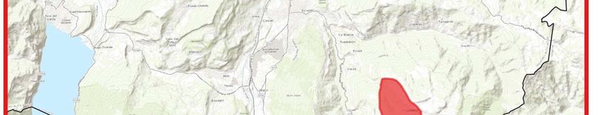
1. Objective
This paper presents the first step of an ongoing peared, to support future educational and dis-
project carried on by the Centro Geo- semination initiatives and to remind future gen-
Cartografico di Studio e Documentazione erations of the horrors of the war. In order to de-
(GeCo) of the University of Trento, that aims to velop and assess the methodology, the area of
identify, locate and analyse the landscape mate- Malga Cheserle - Corno Battisti, in the Munici-
rial features related to the First World War1. It pality of Trambileno (south of the Province of
focuses especially on fortifications, intended as Trento) has been chosen as case study (Fig. 1).
material cultural heritage that risks to disappear, The paper presents the method and some prelim-
and which must be preserved as a physical inary outputs.
memory of one of the most terrible moments in
human history. The identification of these sites 2. Background
has a double objective. The first is the recon-
The centenary of the First World War has been
struction of the proelium, the battle fields, by
the occasion to promote a series of cultural initi-
identifying the position of trenches, bunkers,
atives to recover the historical memory of the
walkways, etc., for a better understanding of the
conflict, and has provided an opportunity for the
war dynamics and the daily life of the soldiers at
historical, social, geographical and archaeologi-
front. The second purpose is the creation of a da-
cal sciences to deal with such a watershed mo-
tabase of the existing artefacts and material her-
ment for the history of humanity and of science
itage related to the war, as well as of those that
and technology (Fox, 2018). As pointed out by
are at risk of obliteration or have already disap-
Imre Demhardt, the First World War was a “ter-
883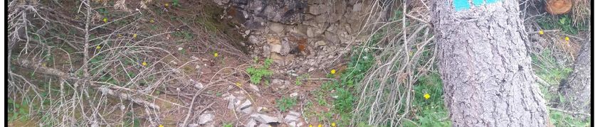
rible mother of invention” (Demhardt, 2018): the After the awareness of the WWI space as re-
needs given by the conflict have led to signifi- search theme of the 1990s, and the subsequent
cant technical advances, both in the war praxis definition of scientific problems, the study of the
and in related sciences. In the field of geogra- landscapes of the Great War has gradually ac-
phy, the last five years have seen numerous pub- quired legitimacy and the recognition of histori-
lications –both at Italian and European level– cal, archaeological and geographical disciplines
concerning various aspects of the Great War (Francis, 2014; Medri, 2018). In this context, at-
(Liebenberg, Demhardt, Vervust, 2016; tempts to identify the material cultural heritage
Demhardt, 2018; Chirico, Conti, 2018; Masetti, of the First World War and rediscover the land-
2018), which can be aggregated into four main scapes of war have multiplied in recent decades;
research lines: 1) the study of the role of geogra- a whole new field of research, named “First
phers and geographic societies in the conflict, in World War Archaeology”, is being developed,
the public debate, in intelligence operations, in based on field surveys and stratigraphic analysis
the development of maps and aerial photos, or as of the trenches (Saunders, 2002; Desfossés,
mere soldiers in military operations; 2) the study Jacques, Prilaux, 2007). The development of
of the impact of war on geographic and carto- tourism linked to celebrations, the spread of re-
graphic practices, caused by technical advances membrance museums and the necessity of
and by the demand for information and data preservation and enhancement of this heritage
from the Army; 3) the critical review of geo- now also impose-on geographers the develop-
historical sources produced during the conflict, ment of methods to reconstruct the effects of the
such as cartography, aerial or terrain photos, re- passage of the Great War and of millions of sol-
ports, writings and memorials, and their poten- diers on Alpine spaces. These spaces are config-
tial for studying both war events and war spaces ured as material custodians and places for pre-
and landscapes; 4) the identification of battle- serving the collective memory of the tragedy
fields and the assessment of their change over (Jansen-Verbeke, George, 2005; Piva, Agostini,
time. 2018). Except for some carefully restored and
highly valued sites, many material traces of the
conflict in the Alps are gradually disappearing.
Some experience has been developed, such as,
the small-scale WEB-GIS on the “Great War
Places” elaborated by the Italian CNR
(http://luoghi grandeguerra.iia.cnr.it/, cfr.; Plini,
Villari, Cailotto, 2018). To reconstruct these
traces, the researcher can benefit from a wide
number of archival, iconographic and field
sources; historical geography, as a carrefour sci-
ence, can carve out a fundamental role in the
documentation and characterization of the herit-
age of almost obliterated landscapes (Wood-
ward, 2014).
3. The case study
The selected case study is located in the Leno
Valleys, in the territory of the municipalities of
Trambileno, Terragnolo and Vallarsa (with an
extension of approximately 168 km²), placed be-
tween the city of Rovereto and the Pasubio mas-
sif (Fig. 1). These valleys are mostly inaccessi-
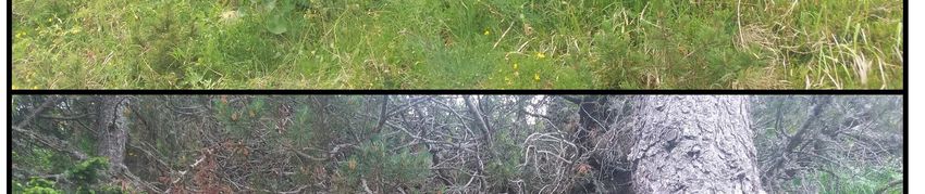
Fig. 1. Localisation of the case study. ble and characterized by steep slopes, as well as
884
by large flat areas or areas with a slight slope.           tire Pasubio area. During the operations, three
The latter are concentrated in the upper part of            Trentino volunteers in the Italian army –
the valleys. The altitude varies between 300 and            Damiano Chiesa, Cesare Battisti and Fabio Fil-
1800 m (Gorfer, 1977).                                      zi– were captured by the Austrians, and execut-
                                                            ed.
This area has been chosen for various reasons.
First, the research outputs can be used to enrich           About 100 000 Italian and Austro-Hungarian
the network of tourist itineraries on the Great             soldiers have lived on the Pasubio for more than
War heritage in Vallagarina, which is already               three years. On the front line, thousands of sol-
widely developed (Museo Storico Italiano della              diers have died in combat, or from wounds,
Guerra, 2018). Secondly, this area, although                killed by the cold and by avalanches. The high
strategically quite marginal during the conflict,           losses imposed the construction of numerous
is very well known since it was the place of the            military hospitals and cemeteries. The Corno di
capture of Cesare Battisti, the socialist-                  Vallarsa, now Corno Battisti, was one of the
irredentist from Trentino, who was put to death             most contested peaks. The Italians conquered it
by the Austrian Empire, and later assumed as                in 1915, lost it in the spring of 1916 and re-
iconic figure of the martyr of the Italian nation2;         gained it in the summer of 1918 with spectacular
every July, local authorities and national institu-         action (Lichem, 1997). Today, the tunnels
tions organize a ceremony and an excursion to               carved into the rock have been made accessible
this place to commemorate the figure of Battisti.           by the work of the Grotte Group “E. Roner”.
Thirdly, it was the scene of strong clashes during          Further restoration interventions promoted by
the Great War, but has been substantially mar-              the “Pasubio100anni” association have been
ginal in the course of the other wars fought be-            planned.
tween the Hapsburg Empire, the French army
and the Kingdom of Italy in the eighteenth cen-             4. Sources and methods
tury; for this reason, most of the fortifications
                                                            To map the landscape of the First World War,
are related only to the Great War, unlike many
                                                            the widest range of possible sources has been
areas of the rest of Trentino (Bortot, 2005; Dai
                                                            used, so as to develop a multi-proxy approach
Prà, Allegri, 2018).
                                                            “model” of investigation; these sources include
Until the end of the First World War, Trentino              historical maps, text documents, current aerial
was part of the Habsburg Empire. In Vallagari-              photos, historical aerial or ground photos, and
na, at the beginning of the 1900s, a defensive              field surveys (Gheyle, et al., 2014). The data
system was built, based on five large fortresses,           collected from each source will be integrated
several bunkers, walkways and defensive sys-                and compared with the others, in order to assess
tems. Between the autumn of 1914 and the                    and to criticize the information potential of each
spring of 1915, the Austro-Hungarian army                   type of source. Clearly, a research model based
strengthened its defences by building the Tiroler           on such a wide range of data needs to be large-
Widerstandlinie (Tyrolean resistance line), a sys-          scale, and to focus on a limited case study, in
tem of trenches and military positions that ex-             contrast to other models of research that use a
tended from Passo del Tonale through the Leno               small scale and focus on large areas (Master,
Valleys to the Marmolada. In the first months of            Stichelbaut, 2009; Stichelbaut, 2006).
the war the Austrian troops withdrew and the
                                                            Most of the mapping projects of material re-
Italian troops occupied without difficulty large
                                                            mains and fortifications of WWI are based on
territories till Rovereto and the Leno Valleys.
                                                            the analysis of aerial photographs taken by mili-
There, both armies focused on the construction
                                                            tary air force during the war. Aerial photography
of roads and paths, trenches, positions for ma-
                                                            has been one of the main advances in intelli-
chine guns and artillery, barracks, deposits and
                                                            gence of the Great War. Zenithal or oblique aer-
cableways. In May 1916 the Austro-Hungarian
                                                            ial photos, taken during reconnaissance expedi-
army launched a major offensive (known as
                                                            tions, were interpreted in the rear areas and used
Strafexpedition) and reoccupied almost the en-

                                                      885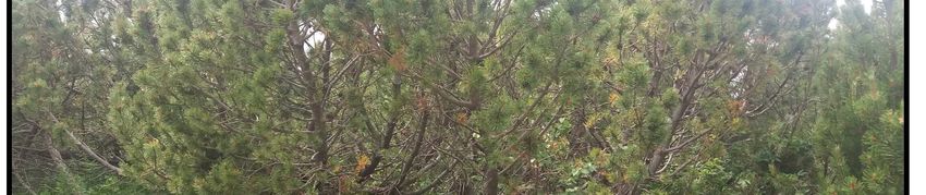
to continuously update tactical and strategic                the great potential, one limitation is that the pho-
maps, both for spying on enemy positions and                 to only shows a small part of the area of interest.
for detecting and monitoring one's own forces
(Chasseaud, 2018).
The use of aerial photos through GIS software
processing is effective in the identification and
mapping of trench systems, as well as bunkers,
roads and barracks (Stichelbaut, 2005, 2006).
Anyway, despite their great potential, these
sources present some problems; because of the
technical limitations of these years, most pic-
tures are oblique, and it is quite difficult to geo-
reference and precisely overlap them with cur-
rent maps.
A new solution for this problem is the recently
developed Monoplotting Tool software created
by the WSL research group. This software works
with DTM and allows to geo-reference the pic-
ture, to vectorize some of its elements and to
import them into a GIS software (Bozzini,
Conedera, Krebs, 2012)3.
During the war, numerous photos were taken in
                                                             Fig. 2. Monte Corno Battisti visto dallo Spiz, no date
the front line, from the trenches or from hight              (Photographic Historical Archive, Museo Storico Ita-
places, to obtain information on the characteris-            liano della Guerra di Rovereto, f. 125).
tics of no man's land, on the trenches and on the
weak and strong points of the deployment. Many               Moreover, the aerial photographs and surveys
of them are large panoramic photographs; this                made by officials were used to elaborate tactical
type of documents was used both to allow im-                 maps, or maps that were updated daily with
mediate recognition of the territory on the part of          manuscript information regarding troops, artil-
front-line commands, and to provide appropriate              lery, the location of fortifications and trenches,
cognitive tools to the commands in the rear to               marked with conventional symbology. Picture nº
help them understand the situation on the battle-            3 shows a tactical map of the Austro-Hungarian
field.                                                       Army, the Spezialkarte 1:75 000, “Rovereto und
                                                             Riva” sheet, that reproduced the trench situation
This software opens new perspectives for the use
                                                             in Trentino on the 5th of May 1918. Manuscript
of photos taken from the ground; until now, they
                                                             information has been added to the basis of the
have been used qualitatively, as a memory of the
                                                             Spezialkarte: the Austro-Hungarian line (blue
daily life in the trench or of fortification archi-
                                                             ink), the Italian line (red ink) and special infra-
tecture; using the Monoplotting Tool, it is possi-
                                                             structures behind the Italian front, such as roads
ble to quantitatively process the landscape pho-
                                                             and cableways (black ink). Maps like this can be
tos, to identify trenches or bunkers, and to geo-
                                                             georeferenced and vectored in order to collect all
locate     them      in    a     GIS      platform.
                                                             the metadata inscribed on them in a geodatabase.
Picture nº 2 shows a photo without date, shot
during the conflict, that represents Monte Corno             Compared with aerial photos, maps provide dif-
Battisti. The trenches and paths between Italian             ferent information: first, they represent the bat-
and Austro-Hungarian lines are quite visible.                tlefield on a particular date, and the integration
Fortification elements have been vectorized and              of a number of them can allow to reconstruct
integrated in the geodatabase in Qgis. Despite               day-by-day events on the front. Secondly, sym-
                                                             bols are more easily understandable than aerial

                                                       886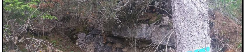
photos, especially for hidden positions, or for
recognizing different types of artefacts (i.e., mil-
itary road, road, path, etc.). On the other hand,
maps, as selected reproduction of real spaces,
have some inherent limitation: often car-
tographies recorded only some of the elements,
and contain unavoidable imprecision of location.
Sometimes, this imprecision in trench patterns
was intentional, as commanders didn’t want to
share too much information with the enemy in
the case maps would be stolen.

                                                              Fig. 4. Some trenches and fortification remains sur-
Fig. 3. Austro-Hungarian “tactical map” with trenches         veyed in the area of Monte Corno, completely covered
position (5.V.1918); the base is the Spezialkarte,            by neo-formation of Pinus mugo.
1:75000, sheet “Rovereto und Riva”.
                                                              “Credevo d’aver avuto nell’anno decorso, sul
A different type of sources to be used are textual            Tonale, sul Bado, una visione ampia della guer-
descriptions. Useful documents can be reports                 ra. Ma mi accordo d’essermi illuso. Quello era
written by battle officials or by the intelligence            sport, dilettantismo. Quella cui assisto oggi è
service, soldier’s memories or correspondence.                guerra e non tanto per l’azione a cui partecipo,
For the case study, inter alia we have the last               quanto per le tracce dell’invasione feroce, e della
letters that Cesare Battisti, wrote to his wife dur-          fuga precipitosa, e del rinato spirito di vendetta
ing the fights for Monte Trappola, Monte Corno                nel nemico, che cerca e non trova la linea della
and Quota 1801. Battisti was a volunteer and a                sua resistenza” (Letter from Cesare Battisti to
politician, but also a geographer; his letters con-           Ernesta Battisti, 7th July 1916; in Pieri, 1965, p.
tain many geographic descriptions.                            82).
“Cara Ernesta, Ricevo la tua del 29. Mi vien re-              On the 4th of July, Battisti was close to Monte
capitata sulla cime Est di Monte Corno, una                   Corno, “horrible and infamous mountains”,
montagnaccia infame, tutta franante, che con-                 where he was settled, “clinging to the slopes,
tendiamo da giorni agli austriaci […] La contesa              without tents, food and water”. Two days later,
è accanita. Noi vinciamo, ma con quanti sacrifi-              he wrote about “the savage invasion” and the
ci, con quali sforzi! Si vive aggrappati ai monti,            “revenge spirit of the enemy”. While it is quite
senza tende, spesso senza cibo, sempre                        difficult to geo-reference this kind of sources,
senz’acqua” (Letter from Cesare Battisti to Er-               especially the mail written by first line soldiers
nesta Battisti, 4th of July 1916; in Pieri, 1965, p.          can be useful to transmit emotions and percep-
79).

                                                        887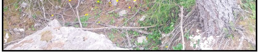
tions of the war (and of the war landscape) by                  field surveys made with a GPS tool (Gheyle, et
people who lived it daily.                                      al., 2014). The area has been surveyed two
                                                                times: the first time, tracks of past defence sys-
                                                                tems and trenches, as well as other landscape
                                                                features related to the passage of the front, have
                                                                been identified; in the second survey s, the local-
                                                                ization of past artefacts has been controlled on
                                                                the field. As a result of field work, and of the
                                                                analysis of current orthophotos, it has been pos-
                                                                sible to verify that the whole area that in histori-
                                                                cal photos appears to be grassland is actually
                                                                completely covered by recent formation of Pinus
                                                                mugo. During the surveys, some elements such
                                                                as trenches, walkways, holes in the ground for
                                                                artillery placement, excavated galleries for host-
                                                                ing troops and pits in the ground made by bom-
                                                                bardments have been localized. Many of them,
                                                                however, are difficult to identify, due to new
                                                                trees, shrub and ground coverage (Fig. 4).
                                                                Figure nº 5 shows some of the first results of the
                                                                digitization process and of the geodatabase that
                                                                has been developed. A division has been made
                                                                according to the different sources that were used,
                                                                such as historical maps, historical photos and
                                                                field surveys. During the next phases, the data-
                                                                base will be developed with new sources; differ-
                                                                ent databases will be integrated, and different
                                                                data will be compared.

                                                                Note
                                                                1
                                                                 The paper is the output of a team work. Anyway, E.
                                                                Dai Prà is the main author of paragraphs 1 and 2, N.
                                                                Gabellieri of paragraphs 3 and 4.
                                                                2
                                                                  Cesare Battisti was a key player in the political and
                                                                civil debate of both Italian Kingdom and Hapsburg
                                                                Empire from 1898 to 1915 (Pieri, 1965; Gatterer,
Fig. 5. Localisation of WWI remains in the studied ar-          1975), as well as a brilliant researcher in the geograph-
eas as result of different source (map; photo) analysis         ic field (Dai Prà, 2018). About the post-war debate and
and field surveys.                                              his mythologizing from a nationalist perspective, see
                                                                Tiezzi, 2007.
Data collected from historical sources can be
                                                                3
compared with autoptic observation, through                       In https://www.wsl.ch/en/projects/monoplotting.html
                                                                (10-7-2019).

Bibliography
Bortot, P. (2005). I forti del Kaiser: opere corazzate nel Sud-Tirolo italiano 1900-1915, Tassotti Ed., Bassano del
    Grappa, p. 197.

                                                          888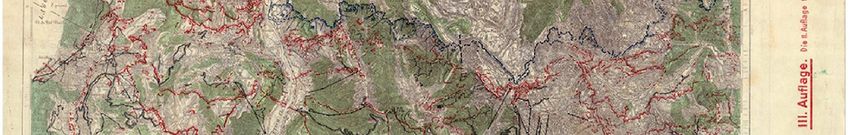
Bozzini, C.; Conedera, M.; Krebs, P. (2012). “A New Monoplotting Tool To Extract Georeferenced Vector Data and
   Orthorectified Raster Data From Oblique Non-Metric Photographs”, International Journal of Heritage In The
   Digital Era, 1, 3, pp. 500-518.
Chasseaud, P. (2018). “British military mapping on the Western Front 1914–18”, International Journal of Cartog-
   raphy, 4 (3), pp. 245-271.
Chirico, M.L.; Conti, S., eds. (2018). La Grande Guerra. Luoghi, eventi, testimonianze, voci, Aracne Ed., Rome, p.
    820.
Dai Prà, E., coord. (2018). Cesare Battisti geografo e cartografo di frontiera, CISGE, Rome, p. 240.
Dai Prà, E.; Allegri, D. (2018). “L’occhio indiscreto del nemico. Spionaggio francese sul confine italo-austriaco”, in
    Masetti, C. coord., Per un Atlante della Grande Guerra, Laboratorio geocartografico “Giuseppe Caraci”, Rome,
    pp. 11-20.
Demhardt, I.J. (2018). “A terrible mother of invention: cartographic progress during World War I”, International
   Journal of Cartography, 4 (3), pp. 241-244.
Desfossés, Y.; Jacques, A.; Prilaux, G. (2007). “Quelle archéologie pour les traces de la Grande Guerre?”, in De-
    moule, J.P. coord., L’archéologie préventive dans le monde, La Découverte, Paris, pp. 151-162.
Fox, A. (2018). Learning to Fight. Military Innovation and Change in the British Army, 1914-1918, Cambridge Uni-
    versity Press, Cambridge, p. 278.
Francis, R.A. (2014). “On war (and geography): Engaging with an environmental frontier”, Progress in Physical Ge-
    ography, 38 (3), pp. 265-270.
Gatterer, C. (1975). Cesare Battisti. Ritratto di un “alto traditore”, La Nuova Italia, Firenze, p. 296.
Gheyle, W., et al. (2014). “Integratin Archaeology and Landscape Analysis for the Cultural Heritage Management of
   a World War I Militarised Landscape: The German Field Defences in Antwerp”, Landscape Research, 39, 5, pp.
   502-522.
Gorfer, A. (1977). Le valli del Trentino. Trentino Orientale, Manfrini, Calliano, p. 1118.
Jansen-Verbeke, M.; George, W. (2015). “Memoryscapes of the Great War (1914-1918): A paradigm shift in tourism
    research on war heritage”, Via. Tourism Review, 8.
Lacoste, Y. (1976). La geographie ca sert d’abord à faire la guerre, Francois Maspero, Paris.
Lichem, H. von. (1997). La guerra in montagna: 1915-1918. vol. II. Il fronte trentino e dolomitico da Rovereto al
    Passo Monte Croce Comelico, Athesia, Bolzano, p. 337.
Liebenberg, E.; Demhardt, I.J.; Vervust, S., coords. (2016). History of Military Cartography, Springer International,
    Heidelberg, p. 375.
Masetti, C., coord. (2018). Per un Atlante della Grande Guerra, Laboratorio geocartografico “Giuseppe Caraci”,
   Rome, p. 304.
Master, P.; Stichelbaut, B. (2009). “From the air to beneath the soil – revealing and mapping great war trenches at
   Ploegsteert (Comines-Warneton), Belgium”, Archaeological Prospection, 16, 4, pp. 279-285.
Medri, M. (2018). “Archeologia della Grande Guerra: metodi e ricerche recenti”, in Masetti C. coord., Per un Atlante
   della Grande Guerra, Laboratorio geocartografico “Giuseppe Caraci”, Rome, pp. 129-134.
Museo Storico Italiano della Guerra (2018). I luoghi della Grande Guerra in Vallagarina, Comunità della Vallagari-
   na, Provincia Autonoma di Trento, Rovereto, p. 40.
Pieri, P. (1965). Cesare Battisti nella storia d’Italia, Temi, Trento, p. 120.
Piva, M.; Agostini, D. (2018). “Progetto di sperimentazione didattica: geolocalizziamo la Grande Guerra. Percorsi e
    trincee sul fronte del Monte Grappa e del Fiume Piave”, in Masetti, C. coord., Per un Atlante della Grande
    Guerra, Laboratorio geocartografico “Giuseppe Caraci”, Rome, pp. 109-122.
Plini, P.; Villari, A.; Cailotto, L. (2018). “Un GIS sui luoghi della grande guerra”, in Masetti C. coord., Per un At-
     lante della Grande Guerra, Laboratorio geocartografico “Giuseppe Caraci”, Rome, pp. 175-180.
Saunders, N.J. (2002). “Excavating memories: archaeology and the Great War, 1914-2001”, Antiquity, 76, pp. 101-
    108.
Stichelbaut, B. (2005). “The application of Great War aerial photography in battlefield archaeology: the example of
    Flanders”, Journal of Conflict Archaeology, 1, pp. 235-243.

                                                           889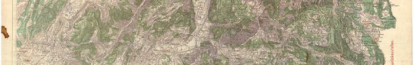
Stichelbaut, B. (2006). “The application of First World War aerial photography to archaeology: the Belgian images”,
    Antiquity, 80, pp. 161-172.
Tiezzi, M. (2007). L’eroe conteso. La costruzione del mito di Cesare Battisti negli anni 1916-1935, Fondazione Mu-
    seo Storico del Trentino, Trento, p. 291.
Woodward, R. (2014). “Military landscapes: Agendas and approaches for future research”, Progress in Human Ge-
   ography, 38, 1, pp. 40-61.

                                                       890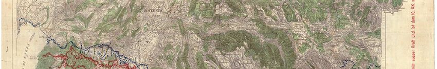
You can also read