TOWARDS FINE-GRAINED ROAD MAPS EXTRACTION USING SENTINEL-2 IMAGERY
←
→
Page content transcription
If your browser does not render page correctly, please read the page content below
ISPRS Annals of the Photogrammetry, Remote Sensing and Spatial Information Sciences, Volume V-3-2021
                                              XXIV ISPRS Congress (2021 edition)

          TOWARDS FINE-GRAINED ROAD MAPS EXTRACTION USING SENTINEL-2
                                  IMAGERY

                                                    C. Ayala1, ∗, C. Aranda1 , M. Galar2
                1
                    Tracasa Instrumental, Calle Cabárceno, 6, 31621 Sarriguren, Navarra - (cayala, caranda)@itracasa.es
                                     2
                                       Institute of Smart Cities (ISC), Public University of Navarre,
                              Campus de Arrosadı́a s/n, 31006, Pamplona, Spain - mikel.galar@unavarra.es

KEY WORDS: Sentinel-2, Remote Sensing, Road Network Extraction, Deep Learning, Convolutional Neural Networks.

ABSTRACT:

Nowadays, it is highly important to keep road maps up-to-date since a great deal of services rely on them. However, to date, these
labours have demanded a great deal of human attention due to their complexity. In the last decade, promising attempts have been
carried out to fully-automatize the extraction of road networks from remote sensing imagery. Nevertheless, the vast majority of
methods rely on aerial imagery (< 1 m), whose costs are not yet affordable for maintaining up-to-date maps. This work proves
that it is also possible to accurately detect roads using high resolution satellite imagery (10 m). Accordingly, we have relied on
Sentinel-2 imagery considering its freely availability and the higher revisit times compared to aerial imagery. It must be taken
into account that the lack of spatial resolution of this sensor drastically increases the difficulty of the road detection task, since the
feasibility to detect a road depends on its width, which can reach sub-pixel size in Sentinel-2 imagery. For that purpose, a new deep
learning architecture which combines semantic segmentation and super-resolution techniques is proposed. As a result, fine-grained
road maps at 2.5 m are generated from Sentinel-2 imagery.

                       1. INTRODUCTION                                  with the European Space Agency (ESA). Moreover, informa-
                                                                        tion produced in the framework of Copernicus is being made
In recent years, there has been a growing research interest in          available free-of-charge to the public. Under the Copernicus
extracting valuable insights from remote sensing imagery. Oc-           programme ESA is currently developing seven Sentinel mis-
casionally assisted by semi-automatic tools, experts carefully          sions to monitor different Earth aspects. In this work we focus
observe aerial and satellite products to extract high-level fea-        on Sentinel-2 (S2), a multi-spectral sensor that provides high-
tures. Since, those labours demand a great deal of human atten-         resolution optical images composed of thirteen bands, princip-
tion, many attempts have been carried out to automatize them            ally in the visible/near infrared (VNIR) and short-wave infrared
(Zhang et al., 2016).                                                   spectral range (SWIR). Among the thirteen bands, only the Red,
                                                                        Green, Blue and Near Infrared ones are provided at the greatest
Among the different objects that could be detected in remote
                                                                        resolution of 10 m. It must be noted that, the high revisit times
sensing imagery, road networks have gained popularity in the
                                                                        provided by S2 allows one to monitor an specific zone up to 70
last decade (Nachmany and Alemohammad, 2019). Ranging
                                                                        times per year in the equator.
from urban planning and cadastral activities to route optimiza-
tion, there are a plethora of services that rely on up-to-date road     Aiming at showing that using high resolution imagery (10 m)
maps to properly work. However, nowadays it is practically im-          it is possible to accurately detect road networks, this paper pro-
possible to keep road maps updated due to the great amount of           poses a novel deep learning architecture which fuses semantic
resources demanded by those labours.                                    segmentation and super-resolution techniques. As a result, not
In recent years, deep learning has received a lot of attention in       only associated costs could be reduced but also, the cartography
both scientific research and practical application. As a result,        update frequency could be increased due to the high revisit
a great deal of automation attempts combining remote sensing            times of high resolution satellites.
imagery with deep learning models have been proposed (Zhu
et al., 2017). Nevertheless, the feasibility to detect complex          The experimental study to validate the proposed approach con-
objects such as road networks, still largely depend on the spatial      sists of a set of 20 cities spread across the Spanish territory.
resolution of the imagery used. That is, the higher the spatial         The data-set has been handcrafted combining S2 imagery with
resolution is, the easier it will be to detect tricky objects.          OpenStreetMap (OSM) annotations. Taking into account that
                                                                        OSM is generated by volunteers, labeling errors may be present.
The vast majority of works employ aerial imagery (< 1 m) to             However, OSM has been widely used to label remote sensing
detect roads, whereas there are few who approach the prob-              data-sets proving that it is possible to achieve a high perform-
lem using very high resolution imagery (< 10 m) (Hoeser and             ance using OSM noisy labels (Kaiser et al., 2017). Additionally,
Kuenzer, 2020). However, increasing the spatial resolution res-         labelling errors in roads are fewer compared to other elements
ult in higher costs, hindering its application on a daily basis.        such as buildings. Our approach has been evaluated using the
                                                                        intersection over union (IoU) and F-score metrics, which are
In Europe, remote sensing data is becoming more accessible              commonly used in semantic segmentation tasks.
and affordable thanks to the Copernicus programme coordin-
ated and managed by the European Commission in partnership              The rest of this work is organized as follows. Firstly, previ-
∗   Corresponding author                                                ous works that uses deep learning techniques to detect roads are

           This contribution has been peer-reviewed. The double-blind peer-review was conducted on the basis of the full paper.
                       https://doi.org/10.5194/isprs-annals-V-3-2021-9-2021 | © Author(s) 2021. CC BY 4.0 License.                      9
ISPRS Annals of the Photogrammetry, Remote Sensing and Spatial Information Sciences, Volume V-3-2021
                                             XXIV ISPRS Congress (2021 edition)

briefly recalled in Section 2. Thereafter, our proposal for detect-   to detect road networks. A benefit of employing high resolution
ing road networks using high resolution imagery is presented in       imagery is that the revisit times are higher, making it possible to
Section 3. Afterwards, the experiments are carried out and dis-       keep road maps updated on a regular basis. However, the lim-
cussed in Section 4. Finally, Section 5 concludes this work and       ited resolution of high resolution imagery drastically increases
present some future research.                                         the complexity of this task.

                                                                      Traditional fully convolutional neural networks (FCNs) (Long
                   2. RELATED WORKS                                   et al., 2015) output segmentation masks maintaining the resol-
                                                                      ution given at the input. That is, if we use a S2 image as input
Nowadays, deep learning-based methods have become the stand-          (10 m) the resulting road segmentation mask will have a spa-
ard for image processing and computer vision tasks (Goodfel-          tial resolution of 10 m. However, it must be taken into account
low et al., 2016). Accordingly, to deal with images, Convolu-         that in a pixel may coexist both (road and no-road) classes since
tional Neural Networks (CNNs) (Lecun et al., 1998) are often          roads can have sub-pixel width.
considered. Remote sensing labours, such as generating road
maps, have taken advantage of that breakthrough.                      This work aims at showing that it is possible to generate se-
                                                                      mantic segmentation masks with greater spatial resolution than
The road network extraction problem can be seen as a semantic
                                                                      the input. Moreover, enhancing the output resolution allows one
segmentation task, since the aim is to assign a label (road or
                                                                      to detect roads whose width, depending on the sensor, could
no-road) to every pixel in a image, thereby allowing the object
                                                                      reach sub-pixel size. For that purpose, a novel deep learning
to be extracted from the image.
                                                                      architecture has been developed combining semantic segment-
The use of deep learning techniques to extract road networks          ation and super-resolution techniques.
from aerial images dates back to 2010 when Mnih et al. (Mnih
                                                                      The most widely used architecture in semantic segmentation
and Hinton, 2010) proposed to utilize restricted Boltzmann ma-
                                                                      tasks is the U-Net fully convolutional network (Ronneberger et
chines (RBMs) to address this problem. Moreover, to refine the
                                                                      al., 2015). Despite, the U-net was originally invented and first
output mappings, they incorporated semantic structures such as
                                                                      used for biomedical image segmentation, it has been adapted
the road connectivity trough the inclusion of a post-processing
                                                                      for a wide variety of segmentation problems. The model pro-
network. Shortly thereafter, in 2012, Mnih and Hinton im-
                                                                      posed in this work is based on the U-Net as it can be seen in
proved their methodology, making use of CNNs (Mnih and Hin-
                                                                      Figure 1.
ton, 2012).

Promising road detection attempts started to emerge as research
in CNNs progressed. Saito et al. (Saito et al., 2016) proposed
a new technique to train CNNs efficiently for extracting roads
and buildings simultaneously. Zhang et al. (Zhang et al., 2018)
relayed on a modified version of the U-Net with residual con-
nections to segment roads. Zhou et al. (Zhou et al., 2018) com-
bined a LinkNet with a pretrained encoder and dilated convolu-
tions to handle this task.

It must be noted that aforementioned works make use of aer-
ial imagery (< 1 m). This is due to the complexity of detect-          Figure 1. U-Net architecture with ResNet-34 as encoder and a
ing roads considering that tree occlusions, building shadows,             bicubic interpolation layer prior to the feature extractor.
and atmospheric and ground conditions can drastically increase
its difficulty. However, the high cost and limited availability       The model consist of a contracting path to capture context in-
of aerial products hinders the possibility of applying proposed       formation, and a symmetric expanding path that enables pre-
methodologies on a daily basis.                                       cise localization. In classical fully convolutional architectures
                                                                      coarse segmentation masks are generated due to the loss of loc-
High resolution sensors (10 m) are not a priori the proper ones       ation information in the encoding path. The lack of fine detail
for detecting complex elements due to their limited spatial res-      is alleviating by the U-Net model, whose main contribution is
olution (Hoeser and Kuenzer, 2020). For this reason few works         to add skip connections. That is to combine high resolution fea-
have assessed their capabilities for the road detection task (Oehm-   tures of the contracting path with the up-sampled output in the
cke et al., 2019, Radoux et al., 2016).                               expanding path, avoiding losing pattern information.
However, high resolution satellite imagery must be taken into         In order to increase the resolution at the output of the network,
account given not only their low cost but also their high revisit     deconvolutional layers are often used. However, when append-
times. Since information produced in the framework of Coper-          ing deconvolutional layers to the U-Net network, they cannot
nicus is available free-of-charge, in this work we make use of        take advantage of the skip connections. For that reason, in this
S2 imagery. Moreover, S2 provides an average revisit interval         work, two main modifications have been made to the vanilla
of 4.5 days at the equator enabling a great deal of monitoring        U-Net architecture:
activities.
                                                                        • An up-scaling layer has been included before the encoder.
      3. TOWARDS FINE-GRAINED ROAD MAPS                                   As a result, the resolution at the input is quadrupled us-
       EXTRACTION USING SENTINEL-2 IMAGERY                                ing the bicubic classical interpolation algorithm. This new
                                                                          outlook allows the network to provide an enhanced version
Considering the elevated costs of using aerial imagery (< 1 m)            of the input, making the most of the U-Net’s skip con-
we have opted for using high resolution satellite imagery (10 m)          nections and thus avoiding the loss of pattern information.

         This contribution has been peer-reviewed. The double-blind peer-review was conducted on the basis of the full paper.
                     https://doi.org/10.5194/isprs-annals-V-3-2021-9-2021 | © Author(s) 2021. CC BY 4.0 License.                      10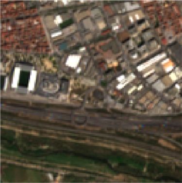
ISPRS Annals of the Photogrammetry, Remote Sensing and Spatial Information Sciences, Volume V-3-2021
                                             XXIV ISPRS Congress (2021 edition)

      However, it must be noted that the increase in the input        Table 1 have been aggregated to build up the label road. Since
      resolution has a negative effect on the computational cost      OSM only provides coordinates of road center-lines, they were
      since the number of parameters is also quadrupled. In the       buffered to match S2 spatial resolution (10 m) before raster-
      experiments we will compare this alternative with the tra-      izing (transforming to pixel coordinates). However, other ap-
      ditional approach of adding deconvolutional layers at the       proaches could have been considered such as determining an
      output.                                                         average road width for each category (Kaiser et al., 2017). No-
                                                                      tice that when rasterizing vector data from OSM one can select
  • The base encoder has been replaced with a ResNet-34 (He           the desired output resolution. In this case, we have both raster-
    et al., 2016). Given the increase in the number of para-          ized to 10 m and 2.5 m to compare the vanilla U-Net with 1x
    meters due to the up-scaling layer, residual connections          output with the modified versions with 4x output.
    are included aiming at reducing the computational cost.
    Moreover, features extracted by residuals models are more             Code   Fclass           Description
    precise than the ones extracted by the vanilla U-Net en-              5111   motorway         Motorway/freeway
    coder, because residual connections exploit all the inform-           5112   trunk            Important roads, typically divided
                                                                          5113   primary          Primary roads, typically national
    ation available along the down-sampling process efficiently.          5114   secondary        Secondary roads, typically regional
                                                                          5115   tertiary         Tertiary roads, typically local
                                                                          5121   unclassified     Smaller local roads
                 4. EXPERIMENTAL STUDY                                    5122   residential      Roads in residential areas
                                                                          5123   living street    Streets where pedestrians have priority
                                                                          5124   pedestrian       Pedestrian only streets
4.1   Data-set                                                            5131   motorway link    Roads connections (same of lower category)
                                                                          5132   trunk link       Roads connections (same of lower category)
                                                                          5133   primary link     Roads connections (same of lower category)
Since open road network extraction data-sets consist of hand-             5134   secondary link   Roads connections (same of lower category)
labeled aerial imagery (Demir et al., 2018, Cheng et al., 2017,
Bastani et al., 2018), we have opted for generating our own               Table 1. OSM classes from the Road layer that have been
data-set. Considering the free availability of their products as                    aggregated to build up the label road.
well as the high revisit times provided, S2 was chosen as high
resolution sensor. Additionally, we have relied on OpenStreet-        For this study, we have selected 20 cities spread across the
Map (OSM) to annotate the imagery on account of the quality           Spanish territory, which have been divided in two sets accord-
of the road labels.                                                   ing to the machine learning standar guidelines (Ripley, 1996).
                                                                      That is, each whole city is assigned to either the training set
Overall, the pipeline for a generic area of interest is depicted      or test set in order to prevent data leakage, as it is indicated
in Figure 2. Firstly, S2 products are queried and downloaded          in Table 2. Figure 3 shows how the data-set is geographically
from the Sentinels Scientific Data Hub (SciHub). Despite 13           distributed.
bands are offered by S2, we will only make use of the Red,
Green, Blue and Near Infrared bands, since they are the only                     City               Dimensions           Set
ones provided at the greatest resolution of 10 m. Additionally,                  A coruña           704 × 576           Training
the Normalized Difference Vegetation Index (NDVI) is com-                        Alicante           1216 × 1472          Training
puted and concatenated to the other bands.                                       Barakaldo          1088 × 896           Training
                                                                                 Barcelona N.       1152 × 1728          Test
                                                                                 Barcelona S.        896 × 1088          Test
                                                                                 Castellón         1024 × 1024          Training
                                                                                 Córdoba           1088 × 1792          Training
                                                                                 Girona             1536 × 1216          Training
                                                                                 León              1216 × 768           Training
                                                                                 Logroño            768 × 960           Training
                                                                                 Madrid N.          1920 × 2688          Training
                                                                                 Rivas-vacı́a       1088 × 1088          Training
                                                                                 Salamanca           832 × 960           Training
                                                                                 San Sebastián      512 × 768           Test
                                                                                 Santander          1152 × 1216          Training
                                                                                 Sevilla            2176 × 2368          Training
                                                                                 Palma              1024 × 1344          Test
                                                                                 Pamplona           1600 × 1536          Test
                                                                                 Vitoria             576 × 896           Training
                                                                                 Zaragoza           2304 × 2752          Training

                                                                          Table 2. Summary of the data-set. Overall, training set is
                                                                         composed by 15 zones (75%) whereas test set consists of 5
                                                                                              zones (25%)

                                                                      It must be noted that open databases such as OSM usually con-
                                                                      tains labeling errors. Despite there is an evident lack of pre-
                                                                      cision in rural areas annotations, OSM has been widely used
  Figure 2. Data-set generation pipeline for a generic area of        to automatically annotate remote sensing data-sets. Moreover,
                           interest.                                  deep learning-based models have been proved capable of learn-
                                                                      ing from noisy data (Mnih and Hinton, 2012). Although in the
Regarding OSM, as a great deal of layers are provided it needs        future we plan to find ways for improving the generated data, in
to be reclassified. That is, several road elements outlined in        this work we rely on OSM annotations without performing any

          This contribution has been peer-reviewed. The double-blind peer-review was conducted on the basis of the full paper.
                      https://doi.org/10.5194/isprs-annals-V-3-2021-9-2021 | © Author(s) 2021. CC BY 4.0 License.                              11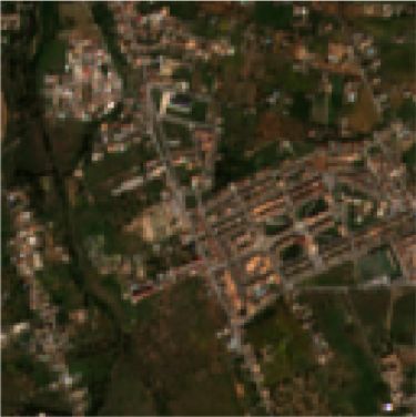
ISPRS Annals of the Photogrammetry, Remote Sensing and Spatial Information Sciences, Volume V-3-2021
                                               XXIV ISPRS Congress (2021 edition)

                                                                         In Table 3, we show the result in terms of IoU and F-score for all
                                                                         the models in the road detection task. Despite metrics are com-
                                                                         puted for each city from the test set individually, the overall per-
                                                                         formance is also included. Moreover, the best results achieved
                                                                         are presented in boldface.

                                                                         In summary, the vanilla U-Net achieves an average IoU of 0.36
                                                                         and F-score of 0.53. However, when the resolution at the out-
                                                                         put is enhanced, both metrics increase. Accordingly, the IoU
                                                                         gets almost doubled (0.61 and 0.68 for the Deconv and Bicubic
                                                                         models respectively) and the F-score also increases (0.75 and
                                                                         0.81, respectively). This is mainly due to the coexistence of
                                                                         multiple classes in a single pixel derived from the limited spa-
      Figure 3. Geographical distribution of the data-set (green         tial resolution. Moreover, as it can be observed, the results are
                     training set / red test set).                       consistent across all the cities in the test set.

pre-processing step.                                                     Table 3 also reveals that up-scaling the input prior to the feature
                                                                         extractor results in a better performance compared to perform-
4.2    Experimental framework
                                                                         ing the up-scaling at the output trough the use of deconvolu-
Keras (Chollet et al., 2015) has been chosen as deep learn-              tional layers (0.68 vs. 0.61 in terms of IoU and 0.81 vs. 0.75
ing framework to implement the architectures proposed in this            in terms of F-score). Therefore, increasing the resolution at
work. All the models have been trained for 100K iterations tak-          the input makes it possible for the U-Net network to learn not
ing batches of 24 samples of 128 × 128 S2 pixels. Moreover,              only how to semantically segmentate the images but also how
samples have been randomly taken considering only samples                to super-resolve them internally. Moreover, since our approach
containing at leas 5% of road pixels. Adam (Kingma and Ba,               keeps the vanilla U-Net architecture intact, shared connections
2015) was chosen as optimizer using a learning rate of 1e-3.             between the encoder and the decoder can refine the resulting
                                                                         segmentation masks. As a result, pattern information is con-
Regarding the loss function, we use a combined loss function             served diminishing the lack of fine detail in the predictions.
(Equation (1)) of Binary Cross-entropy (Ma Yi-de et al., 2004)
and Dice Loss (Sudre et al., 2017). Briefly, the Dice loss con-          Figure 4 visually compares the performance of the proposed
trols the trade-off between false-negatives and false-positives          architecture in some samples taken from the test set. Closely
whereas, the binary cross-entropy is used for curve smoothing.           looking at this figure one draws the same conclusions as those
                                                                         looking at Table 3, with some additional information. Standard
           L(y, ŷ) = 0.5LBCE (y, ŷ) + 0.5LDICE (y, ŷ)                 semantic segmentation models such as the U-Net struggle to
         LBCE (y, ŷ) = −(y log(ŷ) + (1 − y) log(1 − ŷ))               detect sub-pixel sized elements. Therefore, when the output
                                                                   (1)   resolution is increased, models have more room for accurately
                                     2y ŷ + 1
                    LDICE (y, ŷ) =                                      defining small objects. However, when dealing with complex
                                    y + ŷ + 1
                                                                         scenarios such as rural areas, only adding the deconvolutional
The different approaches have been evaluated using both the in-          layers produces a behaviour similar to the usage of Conditional
tersection over union (IoU) and F-score metrics. Closely related         Random Fields, removing noise and better defining the roads.
to the Dice coefficient, the IoU quantifies the percent overlap          On the contrary, the bicubic interpolation at the input allows one
between the target mask and the predicted output. Both IoU               not only to remove noise, but also to detect roads with sub-pixel
and F-score (F1) are computed as indicated in Equation (2).              width.

                           y ∩ ŷ                      2y ŷ             Finally, to assess the generalization capability of the proposed
           IoU (y, ŷ) =               F 1(y, ŷ) =                (2)   architecture to other areas different from the training and testing
                           y ∪ ŷ                     y + ŷ
                                                                         ones, road networks have been extracted for the main cities in
Like other works (Mnih and Hinton, 2010, Zhang et al., 2018)             the Iberian peninsula. Accordingly, the complete map is avail-
we have performed precision relaxation aiming at reducing the            able at our web page. 1
impact of the low spatial resolution on the metrics. That is,
we have discarded doubtful pixels located on the edges of the
roads.                                                                             5. CONCLUSIONS AND FUTURE WORK

The experiments have been run on a computing node with an                In this paper a new deep learning architecture to detect road net-
Intel Xeon E5-2609 v4 @ 1.70 GHz processor with 64 GB of                 works in S2 imagery has been presented. Moreover, our model
RAM memory and 4x NVIDIA RTX2080Ti GPUs with 11 GB                       is capable of detecting roads regardless of their width. Results,
of RAM.                                                                  demonstrates that increasing the resolution at the input of the
                                                                         feature extractor using a classical interpolation algorithm such
4.3    Results and discussion
                                                                         as bicubic can boost both the IoU and F-score metrics.
As we have already mentioned in Section 3, the most widely
used technique to increase the resolution at the output of a fully       Nevertheless, there are still several research lines on this topic
convolutional network is to append deconvolutional layers. Ac-           that should be addressed in the future. The data-set could be
cordingly, the architecture proposed in this work has been com-          1   https://tracasa.es/sin-categoria-en/tracasa-succeeds-in-identifying-
pared not only to the vanilla U-Net but also to an evolved ver-              roads-and-highways-using-images-from-sentinel-satellites-super-
sion with two extra deconvolutional layers.                                  resolved-with-artificial-intelligence/

           This contribution has been peer-reviewed. The double-blind peer-review was conducted on the basis of the full paper.
                       https://doi.org/10.5194/isprs-annals-V-3-2021-9-2021 | © Author(s) 2021. CC BY 4.0 License.                                  12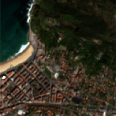
ISPRS Annals of the Photogrammetry, Remote Sensing and Spatial Information Sciences, Volume V-3-2021
                                            XXIV ISPRS Congress (2021 edition)

                                           U-Net x1                U-Net + Deconv x4              U-Net + Bicubic x4 (ours)
                   City                IoU         F-score           IoU           F-score          IoU              F-score
                   Barcelona N.       0.2957       0.4564          0.6250          0.7692         0.7066             0.8280
                   Barcelona S.       0.3409       0.5085          0.5231          0.6869         0.6812             0.8103
                   San Sebastián     0.4044       0.5759          0.6199          0.7654         0.6966             0.8212
                   Palma              0.3956       0.5670          0.6430          0.7827         0.6677             0.8007
                   Pamplona           0.3921       0.5633          0.6400          0.7804         0.6950             0.8200
                   Overall            0.3657       0.5345          0.6102          0.7569         0.6894             0.8161

                                      Table 3. Results obtained in test set with metric relaxation.

          S2 RGB                    Ground Truth             U-Net x1 (0.4654 / 0.5066)      Deconv x4 (0.7353 / 0.8039)   Bicubic x4 (0.8297 / 0.9105)

          S2 RGB                    Ground Truth             U-Net x1 (0.4299 / 0.4809)      Deconv x4 (0.6360 / 0.6970)   Bicubic x4 (0.7153 / 0.7884)

          S2 RGB                    Ground Truth             U-Net x1 (0.5776 / 0.7323)      Deconv x4 (0.5992 / 0.7494)   Bicubic x4 (0.7258 / 0.8411)

          S2 RGB                    Ground Truth             U-Net x1 (0.4794 / 0.6481)      Deconv x4 (0.5416 / 0.7027)   Bicubic x4 (0.8108 / 0.8955)

 Figure 4. Visual comparison between the vanilla U-Net (col. 3), a modified version with two deconvolutional layers (col. 4), and the
proposed architecture which applies a bicubic interpolation prior to the feature extractor (col. 5). The relaxed IoU and F-score metrics
                                               have been also included (IoU / F-Score).

         This contribution has been peer-reviewed. The double-blind peer-review was conducted on the basis of the full paper.
                     https://doi.org/10.5194/isprs-annals-V-3-2021-9-2021 | © Author(s) 2021. CC BY 4.0 License.                                   13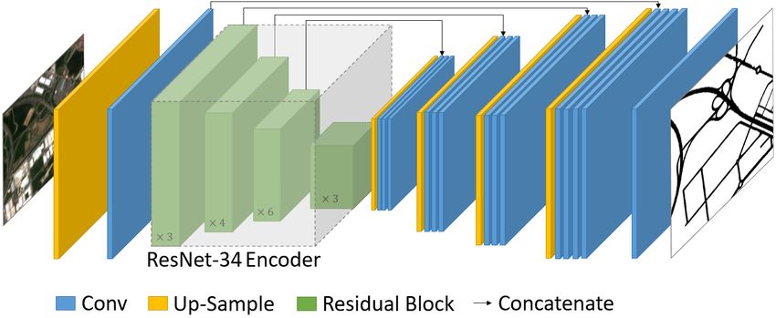
ISPRS Annals of the Photogrammetry, Remote Sensing and Spatial Information Sciences, Volume V-3-2021
                                             XXIV ISPRS Congress (2021 edition)

improved including more images for training and testing. Ad-         Ma Yi-de, Liu Qing, Qian Zhi-bai, 2004. Automated image seg-
ditionally, the location of these images should cover different      mentation using improved pcnn model based on cross-entropy.
parts of the world to make the network more robust. Moreover,        Proceedings of 2004 International Symposium on Intelligent
different images could be considered for a single zone taking        Multimedia, Video and Speech Processing, 2004., 743–746.
advantage of the higher revisit times of S2.
                                                                     Mnih, V., Hinton, G., 2010. Learning to detect roads in high-
With respect to the deep learning architecture, we would like        resolution aerial images. Computer Vision – ECCV 2010, 6316,
to compare the proposed model with other state-of-the-art ap-        210–223.
proaches such as HRNet. Likewise, it would be interesting to
try out other feature extractors different from ResNet-34.           Mnih, V., Hinton, G., 2012. Learning to label aerial im-
                                                                     ages from noisy data. Proceedings of the 29th International
                                                                     Coference on International Conference on Machine Learning,
                6. ACKNOWLEDGEMENTS                                  ICML’12, Omnipress, Madison, WI, USA.

Christian Ayala was partially supported by the Goverment of          Nachmany, Y., Alemohammad, H., 2019. Detecting roads from
Navarra under the industrial PhD program 2020 reference 0011-        satellite imagery in the developing world. Proceedings of the
1408-2020-000008. Mikel Galar was partially supported by             IEEE/CVF Conference on Computer Vision and Pattern Recog-
Tracasa Instrumental S.L. under projects OTRI 2018-901-073,          nition (CVPR) Workshops.
OTRI 2019-901-091 and OTRI 2020-901-050.
                                                                     Oehmcke, S., Thrysøe, C., Borgstad, A., Salles, M. A. V.,
                                                                     Brandt, M., Gieseke, F., 2019. Detecting hardly visible roads
                         REFERENCES                                  in low-resolution satellite time series data. 2019 IEEE Interna-
                                                                     tional Conference on Big Data (Big Data), 2403–2412.
Bastani, F., He, S., Abbar, S., Alizadeh, M., Balakrishnan, H.,
Chawla, S., Madden, S., DeWitt, D., 2018. Roadtracer: Auto-          Radoux, J., Chomé, G., Jacques, D. C., Waldner, F., Bellemans,
matic extraction of road networks from aerial images. 2018           N., Matton, N., Lamarche, C., D’Andrimont, R., Defourny, P.,
IEEE/CVF Conference on Computer Vision and Pattern Recog-            2016. Sentinel-2’s Potential for Sub-Pixel Landscape Feature
nition Workshops (CVPRW), 4720–4728.                                 Detection. Remote Sensing, 8(6).

Cheng, G., Wang, Y., Xu, S., Wang, H., Xiang, S., Pan, C.,           Ripley, B. D., 1996. Pattern Recognition and Neural Networks.
2017. Automatic Road Detection and Centerline Extraction via         Cambridge University Press.
Cascaded End-to-End Convolutional Neural Network. IEEE
                                                                     Ronneberger, O., Fischer, P., Brox, T., 2015. U-net: Convo-
Transactions on Geoscience and Remote Sensing, PP, 1–16.
                                                                     lutional networks for biomedical image segmentation. Lecture
Chollet, F. et al., 2015. Keras. https://keras.io.                   Notes in Computer Science (including subseries Lecture Notes
                                                                     in Artificial Intelligence and Lecture Notes in Bioinformatics).
Demir, I., Koperski, K., Lindenbaum, D., Pang, G., Huang, J.,
Basu, S., Hughes, F., Tuia, D., Raskar, R., 2018. Deepglobe          Saito, S., Yamashita, Y., Aoki, Y., 2016. Multiple Object Ex-
2018: A challenge to parse the earth through satellite images.       traction from Aerial Imagery with Convolutional Neural Net-
2018 IEEE/CVF Conference on Computer Vision and Pattern              works. Journal of Imaging Science and Technology, 60, 10402–
Recognition Workshops (CVPRW), 172–17209.                            1/10402.

Goodfellow, I., Bengio, Y., Courville, A., 2016. Deep Learning.      Sudre, C. H., Li, W., Vercauteren, T., Ourselin, S., Jorge Car-
MIT Press. http://www.deeplearningbook.org.                          doso, M., 2017. Generalised dice overlap as a deep learning loss
                                                                     function for highly unbalanced segmentations. Lecture Notes in
He, K., Zhang, X., Ren, S., Sun, J., 2016. Deep residual learn-      Computer Science (including subseries Lecture Notes in Artifi-
ing for image recognition. Proceedings of the IEEE Computer          cial Intelligence and Lecture Notes in Bioinformatics).
Society Conference on Computer Vision and Pattern Recogni-
tion.                                                                Zhang, L., Zhang, L., Du, B., 2016. Deep Learning for Re-
                                                                     mote Sensing Data: A Technical Tutorial on the State of the
Hoeser, T., Kuenzer, C., 2020. Object detection and image seg-       Art. IEEE Geoscience and Remote Sensing Magazine, 4(2), 22-
mentation with deep learning on Earth observation data: A            40.
review-part I: Evolution and recent trends. Remote Sensing.
                                                                     Zhang, Z., Liu, Q., Wang, Y., 2018. Road Extraction by Deep
Kaiser, P., Wegner, J. D., Lucchi, A., Jaggi, M., Hofmann, T.,       Residual U-Net. IEEE Geoscience and Remote Sensing Letters,
Schindler, K., 2017. Learning Aerial Image Segmentation from         15(5), 749–753.
Online Maps. CoRR.
                                                                     Zhou, L., Zhang, C., Wu, M., 2018. D-linknet: Linknet with
Kingma, D. P., Ba, J. L., 2015. Adam: A method for stochastic        pretrained encoder and dilated convolution for high resolution
optimization. 3rd International Conference on Learning Rep-          satellite imagery road extraction. 2018 IEEE/CVF Conference
resentations, ICLR 2015 - Conference Track Proceedings.              on Computer Vision and Pattern Recognition Workshops (CV-
                                                                     PRW), 192–1924.
Lecun, Y., Bottou, L., Bengio, Y., Ha, P., 1998. LeNet. Pro-
ceedings of the IEEE.                                                Zhu, X. X., Tuia, D., Mou, L., Xia, G., Zhang, L., Xu, F., Fraun-
                                                                     dorfer, F., 2017. Deep Learning in Remote Sensing: A Compre-
Long, J., Shelhamer, E., Darrell, T., 2015. Fully convolutional
                                                                     hensive Review and List of Resources. IEEE Geoscience and
networks for semantic segmentation. Proceedings of the IEEE
                                                                     Remote Sensing Magazine.
Computer Society Conference on Computer Vision and Pattern
Recognition.

         This contribution has been peer-reviewed. The double-blind peer-review was conducted on the basis of the full paper.
                     https://doi.org/10.5194/isprs-annals-V-3-2021-9-2021 | © Author(s) 2021. CC BY 4.0 License.                   14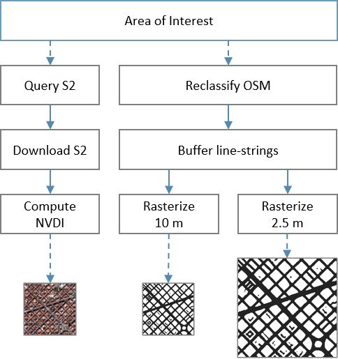
You can also read