March 2021 Tennessee State Climate Summary - East ...
←
→
Page content transcription
If your browser does not render page correctly, please read the page content below
March 2021 Tennessee State Climate Summary
March 2021 Tennessee State Climate Summary
Tennessee Climate Office * East Tennessee State University
Prepared by William Tollefson and Dr. Andrew Joyner
With contributions by Climate Data Representatives at University of Memphis, University of Tennessee-
Martin, Vanderbilt University, University of Tennessee-Institute of Agriculture,
and University of Tennessee-Knoxville
Monthly Temperature Summary:
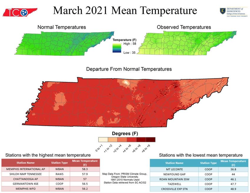
In a major turn-around from February, temperatures across the state in March were well above normal,
with most areas averaging 4-6°F above the normal mean temperature for the month. The month began
close to normal, with a few regions reporting slightly below mean temperatures, but the middle and end
of the month brought temperatures that were consistently warmer than the 30-year climate normal for
March. Looking at the mean temperatures for the month, only the Oak Ridge climate-reporting weather
station recorded temperatures in the top-ten for March (8th warmest March mean temperature). However,
based on the average daily high temperatures it was the 4th warmest March in the Tri-Cities, 8th warmest
March at Oak Ridge, Memphis tied for the 9th warmest, and Chattanooga tied for the 10th warmest. Overall,
temperatures ranged from 11°F at Mt. LeConte on March 7, to 82°F at Woodbury on March 15, Shiloh
National Military Park on March 16, and the Memphis National Weather Service Office on March 17.
1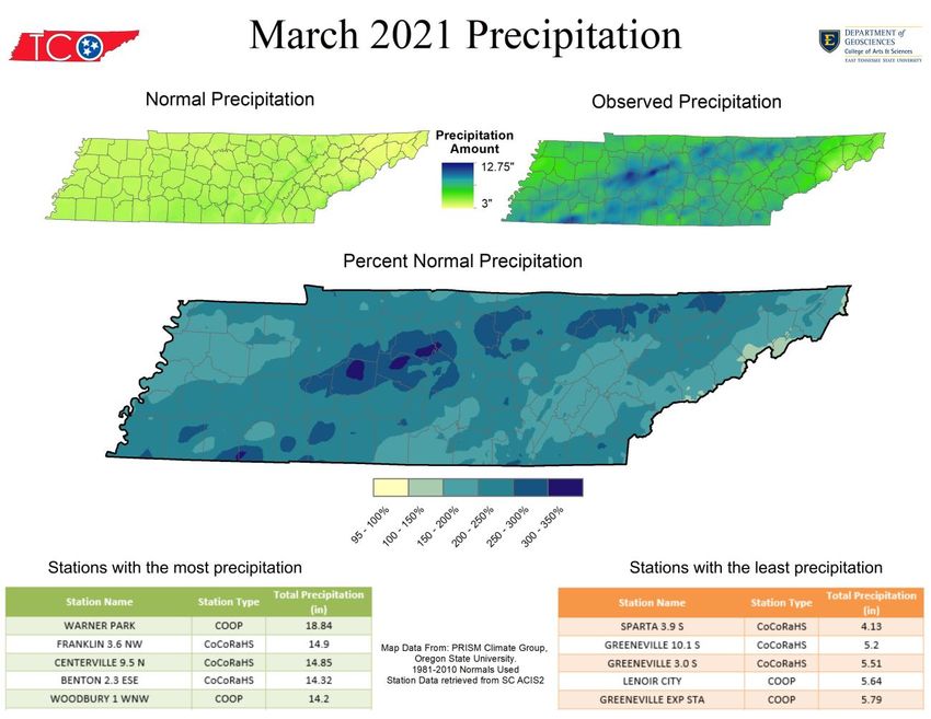
March 2021 Tennessee State Climate Summary

Monthly Precipitation Summary:
Similar to temperatures, precipitation across the state was well above average during March, with a large
portion of the state recording over double the normal March monthly totals. Much of this precipitation
fell as rain during the second half of the month, which produced flash flooding and river flooding across
the state. March 2021 was the 2nd wettest March recorded in the Nashville area, 6th wettest in the Tri-
Cities, 7th wettest in Chattanooga, and 8th wettest in Oak Ridge. Averaged over the entire state, the total
precipitation for the month was 10.06 inches, making it the 4th wettest March for the state as a whole.
Daily rainfall records were set for at least one weather station in the state on March 15, 17, 25, and 27.
The heaviest rainfall occurred on the 27th and overnight into the 28th when a band of flooding rains set up
near the I-40 corridor in Middle Tennessee, with several rain gauges reporting over 6 inches of rain. The
Nashville airport recorded 5.75 inches of rain on March 27, which is the 4th highest daily rainfall total
recorded in the city. The two-day rainfall total in Nashville, at 7.01 inches, was the 2nd highest two-day
total recorded in the city (behind only the rainfall event that produced the May 2010 flooding event).

                                                                                                         2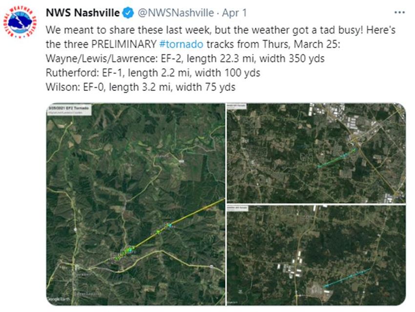
March 2021 Tennessee State Climate Summary

Station Data and Top Tenn. (warmest/wettest, coldest/driest stations of the month):
Station data for airports across the state using WBAN weather stations:
                                         Temperatures (˚F)                                 Precipitation (inches)
 Station Name               Averages                           Extremes                            Totals
                Max      Min      Mean   Depart    High      Date      Low     Date    Obs         Depart    %Norm
   Memphis      68.8     47.9     58.3    +4.3      81       3/27      31       3/3    9.37        +4.21      182%
   Jackson      66.8     42.6     54.7    +3.7      77       3/16      26       3/8    8.44        +3.69      178%
  Clarksville   65.0     41.6     53.3    +4.5      77       3/30      26       3/7    6.76        +2.69      166%
   Nashville    66.7     44.7     55.7    +5.7      79       3/16      28       3/7    12.28       +8.17      299%
 Chattanooga    68.5     45.5     57.0    +4.8      81       3/26      31       3/8    12.06       +7.08      242%
   Crossville   60.8     39.3     50.0    +2.8      71       3/24      22       3/7    9.63        +4.65      193%
   Knoxville    65.7     42.5     54.1    +3.8      77       3/24      27       3/8    9.12        +4.78      210%
   Bristol      64.8 37.2    51.0     +4.3     76     3/24    20     3/8      6.94    +3.50      202%
Departures and %Norm Key: Warmer than Normal, Cooler than Normal; Wetter than Normal, Drier than Normal
                            Hottest Stations (highest maximum temperature)
                                                                               Highest
                                                             Station
                                Station Name                                 Temperature   Date
                                                              Type
                                                                                 (F)
                          WOODBURY 1 WNW                      COOP               82           15
                         SHILOH NMP TENNESSEE                 RAWS               82           16
                                MEMPHIS WFO                   WBAN               82           17
                           AMES PLANTATION                    COOP               81           17
                            SAVANNAH 6 SW                     COOP               81           15
                                WAYNESBORO                    COOP               81           31
                           GERMANTOWN 4SE                     COOP               81           17
                   MOUSETAIL LANDING STATE PARK               COOP               81           31
                           CHATTANOOGA AP                     WBAN               81           26
                       MEMPHIS INTERNATIONAL AP               WBAN               81           27

                                                                                                                     3
March 2021 Tennessee State Climate Summary

                           Coldest Stations (lowest minimum temperature)
                                                       Station        Lowest
                           Station Name                                                Date
                                                        Type       Temperature (F)
                           MT LECONTE                   COOP            11              7
                             TAZEWELL                   COOP              16            9
                        PICKETT STATE PARK              COOP              18            9
                       ROAN MOUNTAIN 3SW                COOP              18            7
                       GREENEVILLE EXP STA              COOP              19            8
                           GAINESBORO                   COOP              19            8
                         NEWFOUND GAP                   COOP              19            7
                          MAYNARDVILLE                  COOP              19            8
                            ERWIN 1 W                   COOP              20            8
                          ELIZABETHTON                  COOP              20            8
                              ONEIDA                    COOP              20            9
                  CROSSVILLE AREA OFFICE TENNESS        RAWS              20            7
                            BRISTOL AP                   WBAN             20            8
                            Five stations tied for 9th coldest temperature (20°F).

                           Warmest Stations (highest mean temperatures)
                                                                        Mean Temperature
                           Station Name                Station Type
                                                                               (F)
                    MEMPHIS INTERNATIONAL AP              WBAN                58.3
                      SHILOH NMP TENNESSEE                 RAWS                 57.9
                         CHATTANOOGA AP                   WBAN                   57
                        GERMANTOWN 4SE                     COOP                 56.5
                          MEMPHIS WFO                     WBAN                  56.2
                    CAMDEN TOWER TENNESSEE                 RAWS                 56.1
                         WINCHESTER 5SE                    COOP                  56
                         AMES PLANTATION                   COOP                 55.9
                  MOUSETAIL LANDING STATE PARK             COOP                 55.9
                   LEWISBURG TOWER TENNESSEE               RAWS                 55.8

                                                                                              4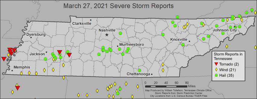
March 2021 Tennessee State Climate Summary

                            Coolest Stations (lowest mean temperatures)
                                                                    Mean Temperature
                           Station Name             Station Type
                                                                           (F)
                            MT LECONTE                  COOP              36.8
                          NEWFOUND GAP                  COOP                  44
                       ROAN MOUNTAIN 3SW                COOP              46.1
                             TAZEWELL                   COOP              47.7
                        CROSSVILLE EXP STN              COOP              48.9
                         CROSSVILLE 7 NW               WBAN                   49
                              NORRIS                    COOP              49.1
                              ONEIDA                    COOP              49.1
                        PICKETT STATE PARK              COOP              49.2
                       CHEROKEE TENNESSEE              RAWS               49.4

                            Wettest Stations (highest precipitation totals):
                                                                    Total Precipitation
                            Station Name             Station Type
                                                                            (in)
                           WARNER PARK                   COOP              18.84
                          FRANKLIN 3.6 NW             CoCoRaHS                14.9
                          CENTERVILLE 9.5 N           CoCoRaHS            14.85
                           BENTON 2.3 ESE             CoCoRaHS            14.32
                         WOODBURY 1 WNW                  COOP                 14.2
                          CENTERVILLE 4NE                COOP             14.13
                          ANTIOCH 4.3ENE              CoCoRaHS            13.64
                   FAIRVIEW BOWIE NATURE CENTER          COOP             13.63
                           CHRISTIANA 5W                 COOP             13.55
                          FAIRVIEW 1.9 ENE            CoCoRaHS            13.52

                             Driest Stations (lowest precipitation totals):
                                                                    Total Precipitation
                            Station Name             Station Type
                                                                            (in)
                            SPARTA 3.9 S              CoCoRaHS             4.13
                         GREENEVILLE 10.1 S           CoCoRaHS                5.2
                          GREENEVILLE 3.0 S           CoCoRaHS                5.51
                             LENOIR CITY                 COOP                 5.64
                        GREENEVILLE EXP STA              COOP                 5.79
                        ROAN MOUNTAIN 3SW                COOP                 5.91
                      COLONIAL HEIGHTS 0.6 SSE        CoCoRaHS                5.96
                         CLARKSVILLE WWTP                COOP                 5.97
                         LIMESTONE 5.0 NNE            CoCoRaHS                5.98
                  SPRINGFIELD EXPERIMENT STATION         COOP                 5.99

                                                                                          5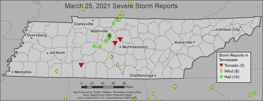
March 2021 Tennessee State Climate Summary

                          Snowiest Stations (highest snowfall accumulations):
                              Station Name              Station Type   Total Snowfall (in)
                              MT LECONTE                   COOP               1.2
                            NEWFOUND GAP                   COOP                T

The Month in Comparison:
Comparing the monthly mean temperature and precipitation totals for March 2021 to the past thirty years
of data for March at automated airport weather stations across the state also shows the wet and warm
pattern; all stations recorded temperature and precipitation above the average values of the last thirty
years. The Nashville and Chattanooga airports stand out in precipitation, both recording a little over a foot
of rain during the month, making this the wettest March in the last thirty years at both stations. Looking
at the longer-term records for both areas, this was the 2nd wettest March in Nashville’s 147-year station
history, coming in just 0.07 inches below the March 1975 record of 12.35 inches of rain. For Chattanooga
it was the 7th wettest March in the station’s 138-year station history, well below the March 1980 record
of 16.32 inches of rain.

                                                                                                           6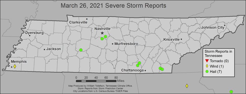
March 2021 Tennessee State Climate Summary

                                             7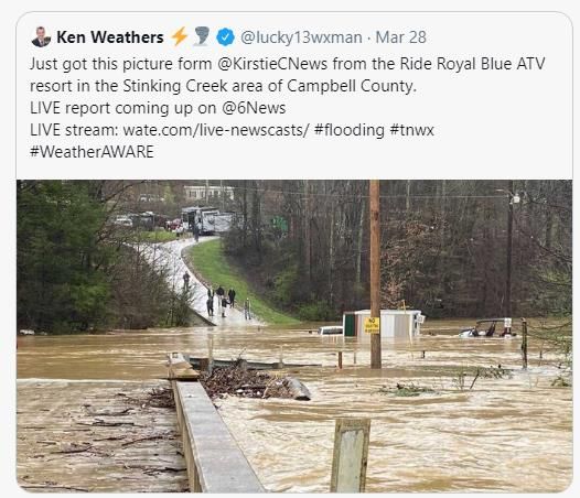
March 2021 Tennessee State Climate Summary

                                             8
March 2021 Tennessee State Climate Summary

Drought Monitor:
Heavy rains at the end of February led to major reductions in Abnormally Dry (D0) conditions across the
state in the first drought monitor release in March, and the well above normal rainfall throughout the rest
of March helped to eliminate the last two areas of D0 in the state this month.

                                                                                                         9
March 2021 Tennessee State Climate Summary

Soil Moisture:
Well above normal rainfall this month also led to major soil moisture recharge across the state, with soil
moisture averages increasing to over 600mm across much of Tennessee, for some locations this was an
increase of 80mm over the levels from the start of the month. This put the average monthly soil moisture
readings close-to or above normal across the state for the month. For the week ending March 28, soil
moisture statistics from the USDA rated topsoil moisture as 47% surplus, 52% adequate, and only 1% short
across the state. Subsoil moisture was rated as 38% surplus, 61% adequate, and 1% short.

                                                                                                       10
March 2021 Tennessee State Climate Summary
11March 2021 Tennessee State Climate Summary
Streamflow:
Streamflow averaged over the month was above normal to much-above normal by the end of March,
and sixteen stream gauges reported above flood stage on Monday, March 29.
12March 2021 Tennessee State Climate Summary
Miscellaneous:
Crop Conditions from USDA: Heavy rains and flooding in the second half of the month was a major
concern for agriculture in the state, and is expected to delay spring planting in some areas. Hay and
roughage supplies were reported as mostly adequate, and cattle condition is currently reported as mostly
good. Winter wheat was also reported with mostly good condition.
Fire Danger: The Interagency Fire Center significant wildland fire outlook shows all of Tennessee, and
surrounding regions, with normal potential for fires during April.
13March 2021 Tennessee State Climate Summary
Snow: After the major winter storms of February, March brought virtually no snow to the state, with the
Mt. LeConte COOP station in the Great Smoky Mountains National Park being the only weather station
that reported measureable snowfall this month. The only other report of snow was a trace at Newfound
Gap, also in the Great Smoky Mountains National Park.
Spring Green-Up: The strong cold spell in February led to a late start to spring across much of the state in
the first few weeks of March. Based on data from the USA National Phenology Network’s “First Leaf Index,”
much of the state recorded a spring that started a few days, to a week later than the 1981-2010 normal
date. However, by the end of March the green-up was well underway and the growing season had started
across the state.
14March 2021 Tennessee State Climate Summary
Story of the Month:
The major story of March was the return of severe weather and flooding during the second half the month.
Severe storms were reported from March 25 to 27, and flooding from March 27 to the end of the month.
There were six injuries reported on March 25 associated with tornadoes or severe thunderstorm winds.
Overnight flooding in Nashville from March 27 into March 28 led to four fatalities, with an additional 130
people being rescued from vehicles or homes. Many smaller rivers had flash floods, like the one recorded
on the Harpeth River at Kingston Springs, which recorded an almost 30-foot rise in stage height over just
24 hours. Even larger rivers, like the Cumberland River at Nashville entered flood stage later in the day on
March 28. For the month of March, Tennessee had five of the six wettest counties in the contiguous United
States! In order, those were Cannon County (13.10”), Rutherford County (12.92”), Williamson County
(12.51”), Maury County (12.46”), and Lewis County (12.35”).
15March 2021 Tennessee State Climate Summary
16March 2021 Tennessee State Climate Summary
Severe storms and flooding also impacted areas in East Tennessee, especially northern sections of the
Cumberland Plateau, including Campbell County which recorded severe flooding. And a powerful hail
storm that impacted Jonesborough and Johnson City in Washington County created ice accumulation
that looked similar to snow.
17March 2021 Tennessee State Climate Summary
18March 2021 Tennessee State Climate Summary
Storm Reports:
*Storm Reports are based on filtered NOAA Storm Prediction Center data or local NWS storm reports. Future quality
control checks may change the official record of severe events, please see spc.noaa.gov for any updates.
There were six days in March with severe weather reports, resulting in a total of 5 tornadoes, 31 reports
of severe wind damage, and 59 reports of hail 1-inch or larger in diameter.
March 15:
Hail:
Time (UTC) Size (in) Location County Lat Lon Comments
7:40 1.00 1 S ST. JOSEPH LAWRENCE 35.02 -87.51 (OHX)
March 17:
Wind:
Time Speed
Location County Lat Lon Comments
(UTC) (mph)
TREES DOWN AND LIKELY POWER LINES TOO ALONG
18:53 -- MEDON MADISON 35.46 -88.87
RIVERSIDE AND ROCHELL ROAD IN MEDON. (MEG)
19March 2021 Tennessee State Climate Summary
March 18:
Hail:
Time Size
Location County Lat Lon Comments
(UTC) (in)
ESTIMATES FROM PEA TO QUARTER SIZE
19:05 1.00 TAZEWELL CLAIBORNE 36.46 -83.58
HAIL ACROSS TAZEWELL. (MRX)
3 NNE
QUARTER SIZED HAIL NEAR THE
19:25 1.00 HOWARD CLAIBORNE 36.51 -83.39
CLAIBORNE/HANCOCK COUNTY LINE. (MRX)
QUARTER
March 25:
Tornados:
Time
Strength Location County Lat Lon Comments
(UTC)
*** 1 INJ *** A STRONG EF-2 TORNADO
TOUCHED DOWN NORTHEAST OF
3 ENE WAYNESBORO. A FEW TREES AND
0:30 EF2 WAYNE 35.34 -87.71
WAYNESBORO OUTBUILDINGS WERE BLOWN DOWN
BEFORE IT MOVED NORTHEAST INTO
AREAS ALONG HWY 99 (OHX)
20March 2021 Tennessee State Climate Summary
Time
Strength Location County Lat Lon Comments
(UTC)
A BRIEF EF-1 TORNADO TOUCHED
DOWN BETWEEN LA VERGNE AND
4E SMYRNA THEN MOVED NORTHEAST
1:11 EF1 RUTHERFORD 35.95 -86.59
NOLENSVILLE THROUGH A RESIDENTIAL AREA OFF
ROCK SPRINGS ROAD. DOZENS OF
HOUSES SUSTAINED MINOR T (OHX)
A BRIEF EF-0 TORNADO TOUCHED
DOWN JUST NORTH OF THE NASHVILLE
4S SUPERSPEEDWAY AND CONTINUED
1:25 EF0 WILSON 36.05 -86.42
GLADEVILLE NORTHEAST BEFORE LIFTING JUST
PRIOR TO REACHING HIGHWAY 231
AND THE CEDARS OF (OHX)
Wind:
Time Speed
Location County Lat Lon Comments
(UTC) (mph)
3 S CHAPEL BOX TRUCK FLIPPED 2.5 MILES SOUTH OF
20:45 -- MARSHALL 35.59 -86.7
HILL HENRY HORTON STATE PARK (OHX)
A SWATH OF VERY DAMAGING STRAIGHT LINE
WINDS STRUCK FROM THE NAPIER AREA JUST
2 SE
21:30 -- DAVIDSON 36.15 -86.76 SOUTHEAST OF DOWNTOWN NASHVILLE NNE
NASHVILLE
ACROSS EAST NASHVILLE AND INGLEWOOD.
NUMEROUS LARGE TR (OHX)
EAST LARGE TREE DOWN ON 19TH AND EASTSIDE.
21:49 -- DAVIDSON 36.17 -86.77
NASHVILLE (OHX)
*** 4 INJ *** VERY DAMAGING STRAIGHT LINE
WINDS STRUCK AN AREA AROUND COOK ROAD
5 ENE
22:00 -- SUMNER 36.61 -86.44 AND HIGHWAY 259 NORTHEAST OF PORTLAND.
PORTLAND
NUMEROUS TREES WERE UPROOTED AND
SEVERAL BARNS AN (OHX)
TSPOTTER REPORT OF A LARGE TREE DOWN ON
1 WNW
22:07 -- DAVIDSON 36.12 -86.78 A HOME OFF OF ELLIOTT AND INVERNESS.
BERRY HILL
(OHX)
2E LARGE TREES DOWN IN EAST NASHVILLE OFF OF
22:22 -- DAVIDSON 36.17 -86.75
NASHVILLE RIVERSIDE AND CARTER. (OHX)
DOWNED TREE KNOCKED DOWN SOME POWER
23:38 -- 4 E SELMER MCNAIRY 35.17 -88.52
LINES ON BYRD. (MEG)
8 SSW TREE AND POWER LINES DOWN ON
2:22 -- BEDFORD 35.38 -86.5
SHELBYVILLE HAWTHORNE HILL ROAD (OHX)
21March 2021 Tennessee State Climate Summary
Hail:
Time Size
Location County Lat Lon Comments
(UTC) (in)
6 WSW TSPOTTER REPORT OF QUARTER SIZE HAIL IN
21:15 1.00 WILLIAMSON 35.86 -87.1
LEIPERS FORK BENDING CHESTNUT (OHX)
4 NNW PRIMM TSPOTTER REPORT OF QUARTER SIZE HAIL IN
21:15 1.00 HICKMAN 35.87 -87.29
SPRINGS BENDING CHESTNUT (OHX)
1 NE HARPETH TSPOTTER REPORT OF HALF DOLLAR SIZED
21:23 1.25 WILLIAMSON 36 -86.89
HILLS HAIL IN GRASSLAND (OHX)
TSPOTTER 1.5" HAIL REPORT FROM GREEN
21:30 1.50 GREEN HILLS DAVIDSON 36.1 -86.82
HILLS (OHX)
TSPOTTER REPORT OF 1.5" HAIL IN
21:58 1.50 COTTONTOWN SUMNER 36.45 -86.54
COTTONTOWN (OHX)
TSPOTTER REPORT OF HAIL NEAR THE
1 WNW
22:00 1.50 DAVIDSON 36.18 -86.8 INTERSECTION OF BRIGHTWOOD AVE.
NASHVILLE
LOMBARDY AVE. (OHX)
2 N WHITE LARGE HAIL REPORT FROM 37048 ABOVE
22:14 2.00 ROBERTSON 36.5 -86.65
HOUSE RIDGE. (OHX)
TSPOTTER REPORT OF 1.5" ESTIMATED HAIL
22:19 1.50 PORTLAND SUMNER 36.59 -86.52
FROM PORTLAND. (OHX)
23:22 1.25 FINGER MCNAIRY 35.35 -88.62 (MEG)
HAIL UP TO THE SIZE OF QUARTERS AT
23:25 1.00 2 SSE SELMER MCNAIRY 35.14 -88.57
WALMART. (MEG)
23:40 1.00 STANTONVILLE MCNAIRY 35.16 -88.43 TIME ESTIMATED FROM RADAR. (MEG)
23:53 1.00 SAVANNAH HARDIN 35.22 -88.24 TIME ESTIMATED FROM RADAR. (MEG)
3 SE
4:28 1.25 MONROE 35.45 -84.14 (MRX)
TARIFFVILLE
3 NE
4:51 1.00 BLOUNT 35.76 -83.79 (MRX)
WALLAND
22March 2021 Tennessee State Climate Summary
March 26:
Wind:
Time Speed
Location County Lat Lon Comments
(UTC) (mph)
EAST LARGE TREE DOWN ON CHERRY ROAD NEAR PARK IN
10:35 -- SHELBY 35.13 -89.87
MEMPHIS MEMPHIS. (MEG)
Hail:
Time Size
Location County Lat Lon Comments
(UTC) (in)
1N
9:30 1.50 MARION 35.22 -85.52 (MRX)
WHITWELL
1 NNW
9:35 1.25 SEQUATCHIE 35.29 -85.46 FROM SOCIAL MEDIA PICTURE. (MRX)
CARTWRIGHT
8N TWITTER PHOTO OF HALF DOLLAR SIZE HAIL
10:18 1.25 HICKMAN 35.66 -87.54
HOHENWALD ON ARNOLD ROAD (OHX)
NICKEL TO QUARTER SIZED HAIL NEAR POLK
10:55 1.00 OCOEE BRADLEY 35.13 -84.72
COUNTY LINE. (MRX)
HAIL FELL AT THE TVA OCOEE HYDRO PLANT
11:00 1.00 PARKSVILLE POLK 35.1 -84.65
ALONG US HWY 64. (MRX)
11:36 1.00 BRENTWOOD WILLIAMSON 36 -86.79 REPORTED AT 9475 SMITHSON LANE (OHX)
11:48 1.00 ANTIOCH DAVIDSON 36.06 -86.67 REPORTED ON ANDERSON ROAD (OHX)
23March 2021 Tennessee State Climate Summary
March 27:
Tornadoes:
Time Strength Location County Lat Lon Comments
5 STRUCTURES WITH MAJOR DAMAGE
AND 3 WITH MINOR DAMAGES.
21:35 -- LEXINGTON HENDERSON 35.65 -88.39
NUMEROUS TREES AND POWER LINES
DOWN. (MEG)
3E VIDEO OF A BRIEF TORNADO EAST OF
22:12 -- DECATUR 35.58 -88.06
DECATURVILLE DECATURVILLE. (MEG)
Wind:
Time Speed Location County Lat Lon Comments
5 NW LARGE BARN DESTROYED AT THE END OF
15:30 -- SULLIVAN 36.59 -82.39
BLOUNTVILLE SILVERS CHAPEL ROAD. (MRX)
5 SE BRISTOL MULTIPLE TREES DOWN ALONG BRISTOL
17:10 -- SULLIVAN 36.52 -82.13
TN CAVERNS HIGHWAY. (MRX)
3 W JACKS SEVERAL LARGE TREES DOWN BETWEEN
21:30 -- CHESTER 35.46 -88.59
CREEK JACKS CREEK AND HENDERSON. (MEG)
HOUSE PARTIALLY DESTROYED AND
SW
21:35 -- HENDERSON 35.65 -88.39 SEVERAL TREES DOWN HWY 22 SOUTHWEST
LEXINGTON
OF LEXINGTON. POSSIBLE TORNADO. (MEG)
SEVERAL TREES DOWN AND POWER LINES
21:50 -- JACKS CREEK CHESTER 35.47 -88.53 DOWN ON HIGHWAY 22A AND MIDDLEFORK
ROAD. (MEG)
STRUCTURAL DAMAGE NEAR TOWN OF
22:02 -- REAGAN HENDERSON 35.52 -88.35
REAGAN. POSSIBLE TORNADO. (MEG)
BARN DAMAGED IN FAR WESTERN
LAUDERDALE COUNTY. MAY BE ASSOCIATED
5 NNW
23:42 -- LAUDERDALE 35.68 -89.9 WITH THE TORNADO THAT CROSSED THE
FULTON
MISSISSIPPI RIVER SOUTH OF OSCEOLA.
(MEG)
23:45 -- SPRING HILL MAURY 35.74 -86.92 5 POWER POLES SNAPPED (OHX)
0:27 -- 3 E DUFF CAMPBELL 36.45 -84.01 A FEW TREES DOWN. (MRX)
4 SW
1:01 -- HOWARD CLAIBORNE 36.43 -83.46 A COUPLE TREES DOWN. (MRX)
QUARTER
24March 2021 Tennessee State Climate Summary
Time Speed Location County Lat Lon Comments
LARGE TREE FELL AND KNOCKED DOWN
1 SE
3:45 -- SHELBY 35.04 -89.67 POWERLINES NEAR COLLIERVILLE SQUARE.
COLLIERVILLE
(MEG)
4:03 -- MOSCOW FAYETTE 35.06 -89.4 TREES DOWN IN MOSCOW. (MEG)
A MOBILE HOME WAS BLOWN OFF ITS
2 ENE
FOUNDATION ON ZINNIA LANE. ANOTHER
4:18 -- GRAND HARDEMAN 35.05 -89.16
NEARBY MOBILE HOME SUSTAINED ROOF
JUNCTION
DAMAGE. (MEG)
6N
4:33 -- HARDEMAN 35.15 -88.89 TREES UPROOTED. (MEG)
MIDDLETON
3 SW
4:46 -- CAMPBELL 36.38 -84.08 SEVERAL TREES DOWN. (MRX)
FINCASTLE
NUMEROUS TREES AND POWER LINES
4:55 -- SELMER MCNAIRY 35.17 -88.59
DOWN ACROSS SELMER. (MEG)
PORCH BLOWN OFF A MOBILE HOME...
5 SSW NUMEROUS TREES DOWN OR UPROOTED...
5:15 -- HARDIN 35.31 -88.25
SALTILLO AND A UTILITY POLE KNOCKED DOWN.
(MEG)
2 ESE
6:16 -- MOUNT HAWKINS 36.54 -82.63 SEVERAL TREES DOWN. (MRX)
CARMEL
1 S LA
9:31 -- CAMPBELL 36.36 -84.13 SEVERAL TREES DOWN. (MRX)
FOLLETTE
11:00 -- CLEVELAND BRADLEY 35.18 -84.87 TREE DOWN BLOCKING ROADWAY. (MRX)
CORRECTS PREVIOUS FLASH FLOOD REPORT
4 SSE BIG FROM 4 SSE BIG SPRING. TREE DOWN AND
11:50 -- BRADLEY 35.34 -84.87
SPRING BLOCKING ROADWAY AT LOWER RIVER RD
NW & CANDIES CREEK RIDGE RD. (MRX)
Hail:
Time Size Location County Lat Lon Comments
2 NW HIGH PICTURE OF HAIL ON SOCIAL MEDIA.
12:05 1.50 MORGAN 36.17 -84.86
POINT (MRX)
12:09 1.00 LEBANON WILSON 36.21 -86.32 (OHX)
13:00 1.00 FARRAGUT KNOX 35.88 -84.18 FROM SOCIAL MEDIA VIDEO. (MRX)
13:04 1.00 SPRING HILL MAURY 35.74 -86.92 (OHX)
THOMPSON'S
13:05 1.00 WILLIAMSON 35.81 -86.91 (OHX)
STATION
3 WNW
14:05 1.00 JEFFERSON 36.03 -83.47 (MRX)
DANDRIDGE
14:15 1.00 ONEIDA SCOTT 36.51 -84.52 VIA SOCIAL MEDIA PICTURE. (MRX)
14:20 1.50 WHITE PINE JEFFERSON 36.1 -83.3 (MRX)
REPORT FROM MPING: HALF DOLLAR
14:55 1.25 1 E GREENEVILLE GREENE 36.17 -82.8
(1.25 IN.). (MRX)
4 W CHURCH
14:55 1.00 HAWKINS 36.53 -82.78 (MRX)
HILL
3 ESE
15:20 1.00 SULLIVAN 36.56 -82.46 (MRX)
BLOOMINGDALE
15:30 1.50 JOHNSON CITY WASHINGTON 36.33 -82.37 TVA CREDIT UNION STADIUM. (MRX)
25March 2021 Tennessee State Climate Summary
Time Size Location County Lat Lon Comments
15:30 1.00 3 E TAZEWELL CLAIBORNE 36.46 -83.52 (MRX)
1E REPORT FROM MPING: QUARTER (1.00
15:41 1.00 CARTER 36.34 -82.22
ELIZABETHTON IN.). (MRX)
GOLF BALL SIZED HAIL IN THE PINE LAKE
21:43 1.75 3 S LEXINGTON HENDERSON 35.61 -88.39
AREA. (MEG)
GOLFBALL SIZED HAIL IN SHADY HILL
21:59 1.75 REAGAN HENDERSON 35.52 -88.35
AREA. (MEG)
22:15 1.00 PARSONS DECATUR 35.65 -88.12 QUARTER SIZED HAIL. (MEG)
23:33 1.00 3 E HUNTSVILLE SCOTT 36.41 -84.44 (MRX)
23:41 1.25 COLUMBIA MAURY 35.62 -87.05 (OHX)
23:55 1.75 2 E SPRING HILL WILLIAMSON 35.74 -86.89 (OHX)
3 NW
0:03 2.25 WILLIAMSON 35.77 -86.69 IN COLLEGE GROVE (OHX)
EAGLEVILLE
7 NW CHAPEL
0:04 1.50 MARSHALL 35.7 -86.78 (OHX)
HILL
0:05 1.50 EAGLEVILLE RUTHERFORD 35.74 -86.65 (OHX)
7 W MARTIN
0:20 1.00 MARION 35.18 -85.67 (MRX)
SPRINGS
6 SSE 1.25 HAIL ON BUZZARD BRANCH DRIVE IN
0:24 1.25 RUTHERFORD 35.77 -86.35
MURFREESBORO CHRISTIANA (OHX)
0:40 1.50 BEECHGROVE COFFEE 35.63 -86.24 (OHX)
3 SSE QUARTER SIZE HAIL REPORT ON HWY 53
1:05 1.00 CANNON 35.78 -86.05
WOODBURY IN SOUTHERN CANNON COUNTY. (OHX)
1:20 1.00 2 N JACKS CREEK CHESTER 35.5 -88.53 MPING REPORT (MEG)
NICKEL TO QUARTER SIZED HAIL BETWEEN
1:31 1.00 MEDON MADISON 35.46 -88.87
JACKSON AND MEDON. (MEG)
5 ESE PING PONG SIZE HAIL NEAR HOLLOW
1:32 1.50 CANNON 35.71 -86.09
BRADYVILLE SPRINGS. (OHX)
2S
1:35 1.00 HAWKINS 36.38 -83.01 (MRX)
ROGERSVILLE
1:45 1.75 BEECH BLUFF MADISON 35.6 -88.63 GOLFBALL SIZED HAIL. (MEG)
2:01 1.00 2 N LEESBURG WASHINGTON 36.33 -82.54 (MRX)
QUARTER SIZED HAIL BETWEEN
2:16 1.00 MIFFLIN CHESTER 35.55 -88.58
HENDERSON AND MIFFLIN. (MEG)
QUARTER SIZED HAIL NEAR COMMUNITY
2:43 1.00 2 N PARSONS DECATUR 35.68 -88.12
OF JEANNETTE. (MEG)
26March 2021 Tennessee State Climate Summary
CPC Outlooks for the Next Month:
Looking ahead to April, the NOAA Climate Prediction Center outlooks show all of Tennessee with a
likelihood of continuing the warmer than normal pattern from March. Luckily they show that wetter than
normal conditions are not very likely to continue. Portions of East Tennessee are shown with chances for
below normal precipitation, while the majority of the state will have equal chances for a normal, wetter,
or drier month.
27You can also read