January 2020 Tennessee State Climate Summary - East ...
←
→
Page content transcription
If your browser does not render page correctly, please read the page content below
January 2020 Tennessee State Climate Summary

      January 2020 Tennessee State Climate Summary
                       Tennessee Climate Office * East Tennessee State University
                          Prepared by William Tollefson and Dr. Andrew Joyner
   With contributions by Climate Data Representatives at University of Tennessee-Martin, Vanderbilt
   University, University of Tennessee-Institute of Agriculture, University of Tennessee-Knoxville, and
                                         University of Memphis

Monthly Temperature Summary:
Mean temperatures for January ran well above normal across the state, with most areas observing
temperatures 4-6°F warmer than normal for the month. The first half of the month was the warmest
period, with many areas recording temperatures 6-10°F above average. January 10th brought record-
high low temperatures across the state, with low temperatures only dropping to 60°F in Memphis, 59°F
in Jackson & Nashville, and 58°F in Clarksville, all of which were about twenty degrees above the normal
high temperature for the date! Then on the 11th, record high temperatures were recorded in the eastern
two-thirds of the state, with high temperatures reaching 77°F in Knoxville, 76°F in the Tri-Cities, 73°F in
Oak Ridge, and 71°F in Nashville. A short cool spell brought temperatures below normal for a few days
around the 19th-23rd, but temperatures for the end of the month returned to above normal conditions.

                                                                                                          1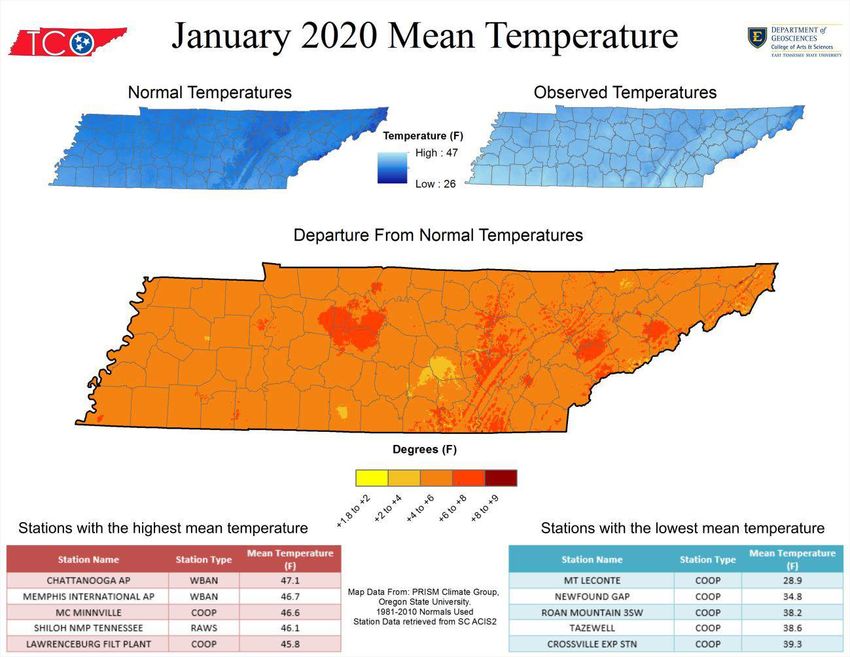
January 2020 Tennessee State Climate Summary
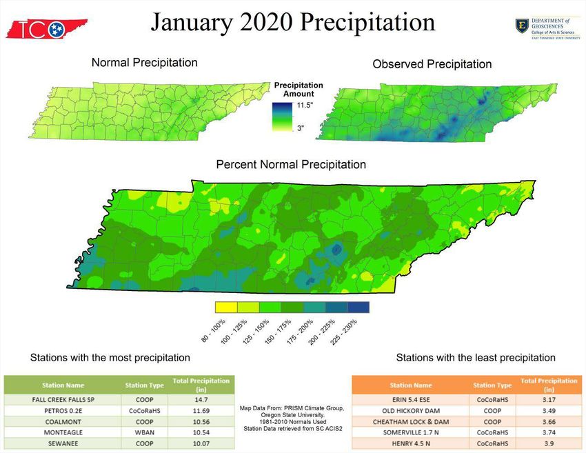
Monthly Precipitation Summary:
Almost all areas of the state recorded above normal precipitation for the month, with a majority of the
state recording 125-175% of normal January precipitation totals. Most of that precipitation occurred as
rainfall in the first half of the month, with widespread rainfall totals of more than four inches, or double
the normal amount for the first two weeks of January. In the second half of the month, precipitation
patterns were more varied, with most areas recording below normal precipitation; however, some
smaller portions of the state did record above normal precipitation during the third or fourth weeks of
the month. With the much above normal temperatures observed, almost all precipitation for the month
came in the form of rainfall. Most locations in the state recorded no measurable snow accumulations,
but light snow showers or flurries occurred at almost all locations across the state on the 20th or 21st on
the tail end of a strong cold front that swept the state.
2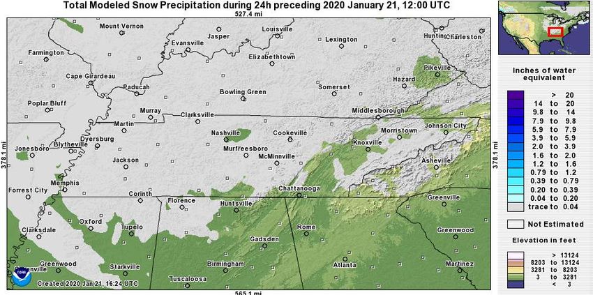
January 2020 Tennessee State Climate Summary

Station Data and Top Tenn. (warmest/wettest, coldest/driest stations of the month):
Station data for airports across the state using WBAN weather stations:
                                             Temperatures (˚F)                                Precipitation (inches)
  Station Name                 Averages                                Extremes                      Totals
                 High   Low       Mean    Depart      High       Date       Low     Date    Obs    Depart     %Norm
   Memphis       54.7   38.6       46.7      +5.5      73        01/11       23    01/20    6.44    +2.46      162%
   Jackson       52.6   35.4       44.0      +5.8      68        01/15       20    01/22    5.31    +1.24      130%
   Clarksville   49.8   33.7       41.8      +6.0      70        01/15       16    01/21    5.04    +1.73      152%
   Nashville     53.2   36.9       45.0      +7.3      71        01/11       20    01/22    5.08    +1.33      135%
 Chattanooga     55.5   38.7       47.1      +6.6      73        01/11       22    01/22    5.97    +1.06      122%
   Crossville    49.0   33.9       41.5      +5.7      65        01/11       16    01/22    7.04    +2.28      148%
   Knoxville     53.3   37.2       45.2      +7.0      77        01/11       18    01/22    7.26    +2.94      168%
    Bristol     51.2 33.8    42.5     +7.3      76     01/11    14     01/22 4.36 +0.99          129%
Departures and %Norm Key: Warmer than Normal, Cooler than Normal; Wetter than Normal, Drier than Normal
                           Hottest Stations (highest maximum temperature)
                                                       Station      Highest
                              Station Name                                         Date
                                                        Type    Temperature (F)
                         NEWPORT 1 NW                   COOP          79             11
                          KNOXVILLE AP                 WBAN           77             11
                    HAMBLEN CO HQ TENNESSEE             RAWS          77             11
                    MORRISTOWN RADIO WCRK               COOP          77             12
                        MORRISTOWN WFO                  COOP          77             11
                           BRISTOL AP                  WBAN           76             11
                       GREENEVILLE EXP STA              COOP          76             12
                        ROGERSVILLE 1 NE                COOP          76             12
                          DECATUR 7NE                   COOP          74             12
                     10-way tie for 10th warmest highest maximum temperature of 73°F

                               Coldest Stations (lowest minimum temperature)
                                                             Station         Lowest
                               Station Name                                                 Date
                                                              Type        Temperature (F)
                             MT LECONTE                       COOP              2            22
                          CENTERVILLE 4NE                     COOP              5            20
                         PICKETT STATE PARK                   COOP              7            22
                           NEWFOUND GAP                       COOP              7            22
                        ROAN MOUNTAIN 3SW                     COOP             10            22
                              TAZEWELL                        COOP             10            23
                   UT MARTIN BRANCH EXP STATION               COOP             11            21
                               ONEIDA                         COOP             12            22
                        BIG SOUTH TENNESSEE                   RAWS             13            22
                        CHEROKEE TENNESSEE                    RAWS             13            21
                       COKER CREEK TENNESSEE                  RAWS             13            22
                           MAYNARDVILLE                       COOP             13            22

                                                                                                                       3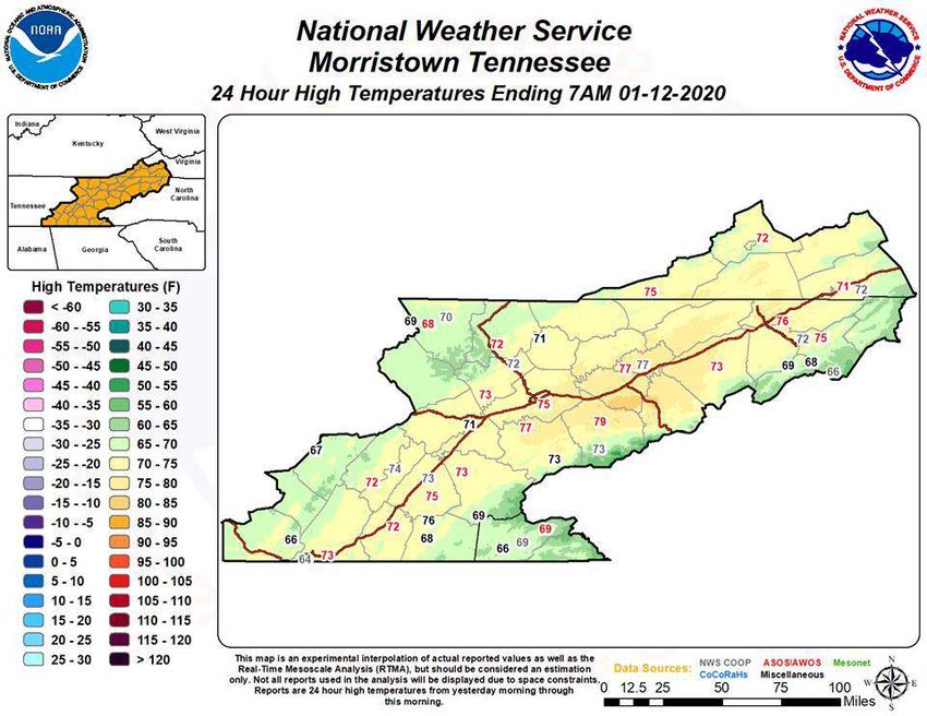
January 2020 Tennessee State Climate Summary

                           Warmest Stations (highest mean temperatures)
                                                                    Mean Temperature
                            Station Name           Station Type
                                                                           (F)
                        CHATTANOOGA AP                WBAN                47.1
                    MEMPHIS INTERNATIONAL AP          WBAN                46.7
                          MC MINNVILLE                COOP                46.6
                      SHILOH NMP TENNESSEE            RAWS                46.1
                    LAWRENCEBURG FILT PLANT           COOP                45.8
                    FAYETTEVILLE WATER PLANT          COOP                45.4
                        GERMANTOWN 4SE                COOP                45.3
                           KNOXVILLE AP               WBAN                45.2
                        NASHVILLE INTL AP             WBAN                 45
                             PIKEVILLE                COOP                 45

                             Coolest Stations (lowest mean temperatures)
                                                                    Mean Temperature
                            Station Name            Station Type
                                                                           (F)
                           MT LECONTE                  COOP               28.9
                         NEWFOUND GAP                  COOP               34.8
                       ROAN MOUNTAIN 3SW               COOP               38.2
                             TAZEWELL                  COOP               38.6
                        CROSSVILLE EXP STN             COOP               39.3
                            COALMONT                   COOP               39.8
                          MAYNARDVILLE                 COOP               39.9
                   UT MARTIN BRANCH EXP STATION        COOP                40
                              ONEIDA                   COOP               40.1
                       CHEROKEE TENNESSEE              RAWS               40.2
                           BETHPAGE 1 S                COOP               40.2

                            Wettest Stations (highest precipitation totals)
                                                                    Total Precipitation
                            Station Name             Station Type
                                                                            (in)
                         FALL CREEK FALLS SP            COOP               14.7
                             PETROS 0.2E              CoCoRaHS             11.69
                             COALMONT                   COOP               10.56
                             MONTEAGLE                  WBAN               10.54
                              SEWANEE                   COOP               10.07
                      LAWRENCEBURG FILT PLANT           COOP               9.92
                        LAWRENCEBURG 1.4 E            CoCoRaHS             9.59
                            MT LECONTE                  COOP                9.5
                          FAYETTEVILLE 8.6 S          CoCoRaHS             9.37
                              KINGSTON                  COOP               9.11

                                                                                          4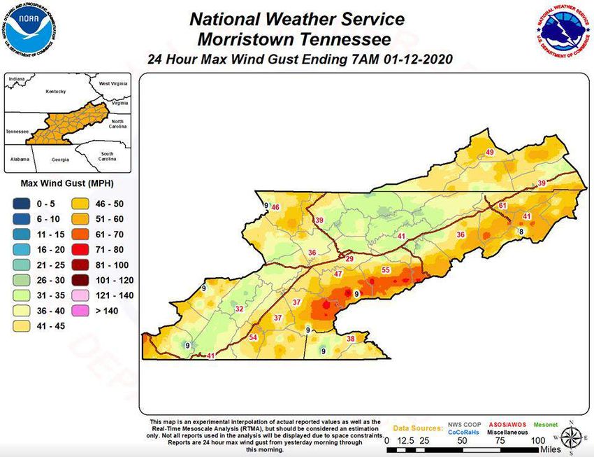
January 2020 Tennessee State Climate Summary

                              Driest Stations (lowest precipitation totals)
                                                                        Total Precipitation
                             Station Name               Station Type
                                                                                (in)
                             ERIN 5.4 ESE                CoCoRaHS              3.17
                          OLD HICKORY DAM                  COOP                3.49
                       CHEATHAM LOCK & DAM                 COOP                3.66
                          SOMERVILLE 1.7 N               CoCoRaHS              3.74
                             HENRY 4.5 N                 CoCoRaHS               3.9
                           OAK GROVE 3.0 E               CoCoRaHS              4.31
                         GERMANTOWN 4SE                    COOP                4.33
                             BRISTOL AP                    WBAN                4.36
                            LEBANON 7 N                    COOP                4.43
                         CLARKSVILLE 4.9 NW              CoCoRaHS              4.49

                                            Snowiest Stations
                             Station Name                Station Type Total Snowfall (in)
                             MT LECONTE                      COOP                20.5
                           NEWFOUND GAP                      COOP                 4.5
                        ROAN MOUNTAIN 3SW                    COOP                 1.1
                         CROSSVILLE EXP STN                  COOP                 0.6
                          GATLINBURG 2 SW                    COOP                 0.5
                           KYLES FORD 1.0 N                CoCoRaHS               0.4
                         CLARKRANGE 6.0 NE                 CoCoRaHS               0.3
                       NASHVILLE BERRY FIELD                 COOP                 0.2
                           GREEN HILL 0.3 N                CoCoRaHS               0.2
                           GALLATIN 5.7 SSE                CoCoRaHS               0.2
                           CROSSVILLE 4.7 S                CoCoRaHS               0.1
                           RICKMAN 3.8 ESE                 CoCoRaHS               0.1
                   An additional 86 stations reported a trace of snowfall during the month.

                                                                                              5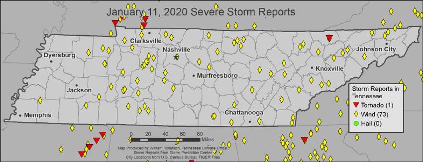
January 2020 Tennessee State Climate Summary

Drought Monitor:
Due to the abundant rainfall at the beginning of the month, and in previous months, Tennessee remained
clear of any drought conditions during January.

The Month in Comparison:
As noted in the monthly temperature and precipitation summaries, January 2020 was warmer and
wetter than normal. Comparing this month to the previous 30 years of data for January we can see that
Chattanooga had its second warmest January in this time period (only 2017 was warmer), Nashville,
Knoxville, and the Tri-Cities airports had their third warmest Januaries for this period (with only 2017
and 2006 being warmer), and Memphis and Jackson had their fourth warmest January for this period.
While precipitation was above normal, several other years had even wetter Januaries; only Memphis
had one of its top 5 wettest Januaries.

                                                                                                           6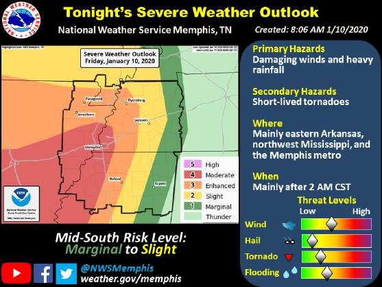
January 2020 Tennessee State Climate Summary

                                               7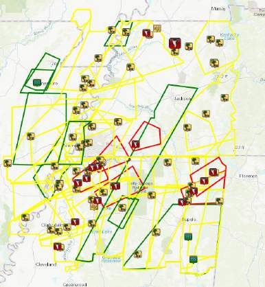
January 2020 Tennessee State Climate Summary

                                               8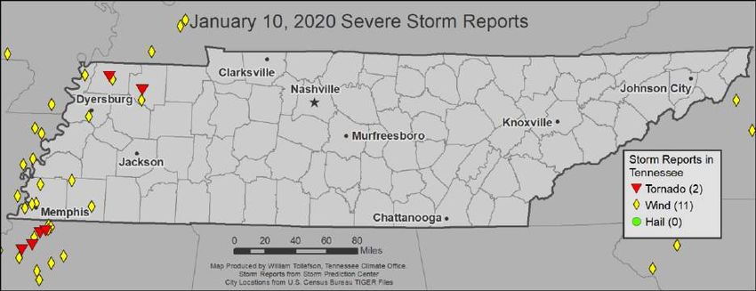
January 2020 Tennessee State Climate Summary

Soil Moisture:
Soil moisture levels across Tennessee were above normal for January, with soil moistures in the 500 to
600mm range. Most of the state recorded an increase in soil moisture levels over the month, but some
areas in Northeast Tennessee saw minor drops in soil moisture levels (about a 10mm decrease from the
end of December to the end of January).

                                                                                                     9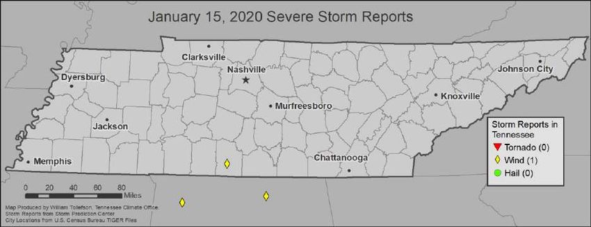
January 2020 Tennessee State Climate Summary

                                               10
January 2020 Tennessee State Climate Summary
Streamflow:
Streamflow levels across the state were generally above, to much above normal for this time of year;
with a few stream gauges in northeast Tennessee and one station each in Middle and West Tennessee
being in the normal range.
11January 2020 Tennessee State Climate Summary
Miscellaneous:
Crop Conditions from USDA: Crop progress and condition reports have ended for the season, and the
USDA will resume issuing the reports for the state in April 2020.
Fire Danger:
The significant wildland fire outlook for February from the Interagency Fire Center shows all of Tennessee
will have a below normal risk for wildfires next month.
Snow: Outside of the highest mountain elevations only minor snowfall occurred this month. The Mt.
LeConte COOP weather station (the highest elevation weather station in the state, located at 6,493 ft in
the Great Smoky Mountains National Park) recorded 20.5” of snow over the month. The next highest
monthly snow total at Newfound Gap (also in GSMNP, but about 1,500 ft lower in elevation) was only 4.5”.
Outside of the mountains, snow totals for the month were less than one inch. The biggest coverage of
snowfall occurred on the 20th-21st with almost statewide mixed precipitation or light snowfall, resulting in
many locations with a trace to 0.3 inches of snow accumulation.
12January 2020 Tennessee State Climate Summary
Story of the Month:
The major story of the month was the much above normal warmth, particularly the first half of the month
when severe storms, intensified by the warmth, occurred on the 10th and 11th. Severe weather was well
forecasted along a strong cold front that swept the state on the 10th and 11th. The storm system first
brought southerly winds and a surge of warm, moist air to the state, followed by a strong squall line with
isolated tornadoes, and several reports of severe wind across the state (more detailed storm reports are
given in the Storm Reports section).
Posts from the NWS Memphis Facebook page highlighting the potential severe weather (left), and showing the
warnings issued paired with storm reports (right).
The eastern portion of the state had another day in the warm sector of the storm on the 11 th, and with
southerly winds leading to downslope warming in the Tennessee Valley temperatures surged into the mid
to upper 70’s across the region. The 11th also brought high winds and high temperatures, with high winds
produced by both a mountain wave event and severe storms, wind gusts of 30-60mph were recorded
throughout East Tennessee.
13January 2020 Tennessee State Climate Summary
14January 2020 Tennessee State Climate Summary
Storm Reports:
Severe storms occurred on three days during the month. Most severe weather reports were associated
with the strong frontal system that moved across the state on January 10th and 11th, while there was one
other isolated severe wind report on January 15th. For the month, the state reported three tornadoes, 85
severe wind occurrences, and no severe hail.
*Storm Reports are based on unfiltered Storm Prediction Center data. Future quality control checks may change the
official record of severe events, please see spc.noaa.gov for any updates.
January 10:
Tornadoes:
Time
Strength Location County Lat Lon Comments
(UTC)
3 NW EF-1 TORNADO DESTROYED SEVERAL BARNS
10:38 EF-1 OBION 36.37 -89.19
TROY AND OUTBUILDINGS. (MEG)
2 NE SHORT TRACK EF-0 TORNADO. OUTBUILDINGS
11:58 EF-0 WEAKLEY 36.25 -88.8
SHARON AND SHEDS DESTROYED. (MEG)
Wind:
Time Speed
Location County Lat Lon Comments
(UTC) (mph)
9:21 -- TIPTONVILLE LAKE 36.38 -89.47 TREES SNAPPED / UPROOTED (MEG)
9:44 -- TIPTONVILLE LAKE 36.38 -89.47 LARGE TREE LIMBS SNAPPED. (MEG)
IN THE FOWLKES AREA... NUMEROUS
UPROOTED AND DOWNED TREES. ONE
4 SSW
10:15 -- DYER 35.99 -89.41 CARPORT SEVERELY DAMAGED AND ONE
DYERSBURG
HOME SUSTAINED MINOR ROOF DAMAGE.
(MEG)
4 NW APPROXIMATELY 2 DOZEN UTILITY POLES
10:25 -- SOUTHWEST SHELBY 35.1 -90.11 WERE DOWN ACROSS THE ROAD ON
MEMPHIS PRESIDENT'S ISLAND. (MEG)
1 NNE STRUCTURAL DAMAGE TO BUILDINGS.
10:33 -- MIDTOWN SHELBY 35.15 -89.98 ROOFING BLOWN OFF... DAMAGING NEARBY
MEMPHIS VEHICLES (MEG)
NUMEROUS TREES DOWN AND A HOME WAS
10:40 -- 1 NE TROY OBION 36.35 -89.15 DAMAGED ON KEY ROAD. POWERLINES DOWN
IN THE AREA. (MEG)
15January 2020 Tennessee State Climate Summary
Time Speed
Location County Lat Lon Comments
(UTC) (mph)
1 ENE
TREES DOWN AT BAPTIST COLLEGE OF HEALTH
10:45 -- DOWNTOWN SHELBY 35.14 -90.03
SCIENCE ON UNION AVE (MEG)
MEMPHIS
BIG TREES DOWN ON BRADEN ROAD AND
1 NNW
11:00 -- FAYETTE 35.38 -89.58 HWY 59. 4 UTILITY POLES DOWN AT MACON
BRADEN
SUBSTATION NEAR GAINESVILLE ROAD. (MEG)
3W
11:15 -- SHELBY 35.33 -89.94 TREES SNAPPED AND UPROOTED. (MEG)
MILLINGTON
CONCENTRATED TREE DAMAGE NEAR THE
2 ESE
11:37 -- FAYETTE 35.14 -89.34 INTERSECTION OF EBENEZER LOOP AND
WILLISTON
DUSCOE ROAD. (MEG)
DAMAGE TO ROOFS... UTILITY POLES... AND
11:55 -- GREENFIELD WEAKLEY 36.16 -88.8
TREES. (MEG)
January 11:
Tornadoes:
Time
Strength Location County Lat Lon Comments
(UTC)
THE TORNADO INITIALLY TOUCHED DOWN
ON PINE AVENUE TO THE NW OF NEW
22:55 UNK TAZEWELL CLAIBORNE 36.46 -83.58 TAZEWELL BLOWING OFF HALF OF THE ROOF
OF A BARN AND UPROOTING OR SNAPPING
SEVERAL TREES. THE TORNADO (MRX)
Wind:
Time Speed
Location County Lat Lon Comments
(UTC) (mph)
BIG TREES DOWN ON BRADEN
ROAD AND HWY 59. 4 UTILITY
12:00 -- 1 NNW BRADEN FAYETTE 35.38 -89.58 POLES DOWN AT MACON
SUBSTATION NEAR GAINESVILLE
ROAD. (MEG)
STRUCTURAL DAMAGE TO A FEW
12:05 -- GLEASON WEAKLEY 36.22 -88.61 HOMES IN THE GLEASON AREA. A
FEW TREES DOWN AS WELL. (MEG)
16January 2020 Tennessee State Climate Summary
Time Speed
Location County Lat Lon Comments
(UTC) (mph)
MULTIPLE TREES AND POWERLINES
12:30 -- MCNAIRY MCNAIRY 35.32 -88.63 DOWN ACROSS MCNARY COUNTY.
(MEG)
ROADS BLOCKED BY DOWNED
TREES ACROSS THE COUNTY...
12:35 -- PARIS HENRY 36.3 -88.31 SCATTERED POWER OUTAGES.
TIME ESTIMATED FROM RADAR.
(MEG)
6 INCH DIAMETER TREE LIMBS
BROKEN... HEAVY TREE DAMAGE
12:43 -- BRUCETON CARROLL 36.03 -88.25
THROUGHOUT THE CITY... FENCES
UPROOTED (MEG)
A TREE DOWN ACROSS CENTER
12:47 -- 4 SSW REAGAN CHESTER 35.47 -88.37 POINT ROAD IN FAR EASTERN
CHESTER COUNTY. (MEG)
TWO TREES FELL ON HOUSE IN
12:50 -- BRUCETON CARROLL 36.03 -88.25
BRUCETON. (MEG)
BARN DAMAGED... TREES AND
12:50 -- HOLLOW ROCK CARROLL 36.04 -88.27 POWER LINES DOWN. TIME
ESTIMATED. (MEG)
2 WNW TREE DOWN ON HIGHWAY 69A AT
12:50 -- HENRY 36.26 -88.19
SPRINGVILLE NEW HARMONY CHURCH. (MEG)
TREES DOWN AND MINOR ROOF
13:00 -- PARSONS DECATUR 35.65 -88.12
DAMAGE (MEG)
NUMEROUS TREES AND POWER
LINES WERE BLOWN DOWN ON
LEATHERWOOD ROAD WITH THE
13:11 -- 3 SSW DOVER STEWART 36.44 -87.86
ROADWAY BLOCKED IN SEVERAL
PLACES NEAR KEEL SPRINGS. 730
HOMES WITHOUT POWER (OHX)
JUST SOUTH OF
DOVER...NUMEROUS TREES AND
13:15 -- 1 S DOVER STEWART 36.47 -87.84
POWER LINES DOWN. 730 HOMES
WITHOUT POWER (OHX)
9 SSE NEW TREE REPORTED DOWN ON
13:18 -- HUMPHREYS 35.9 -87.88
JOHNSONVILLE ROBERTS CREEK ROAD (OHX)
OUTBUILDING AT PERRY COUNTY
13:25 -- 2 SSW LINDEN PERRY 35.59 -87.85 SHERIFF OFFICE WAS HEAVILY
DAMAGED (OHX)
TREE DOWN ON MARSH CREEK RD.
13:30 -- 2 SW LINDEN PERRY 35.59 -87.87 SCATTERED TREE DAMAGE
THROUGHOUT THE COUNTY. (OHX)
WINDOW BLOWN OUT AT DOLLAR
GENERAL. SEVERAL OTHER
13:30 -- LINDEN PERRY 35.61 -87.84 BUSINESSES SUFFERED
SIGN...ROOF...AND EXTERIOR
DAMAGE. (OHX)
TREES CAME DOWN ONTO POWER
13:42 -- ERIN HOUSTON 36.32 -87.7
LINES ON BOONE STREET (OHX)
17January 2020 Tennessee State Climate Summary
Time Speed
Location County Lat Lon Comments
(UTC) (mph)
8 WSW SCATTERED TREE DAMAGE ACROSS
13:45 -- HICKMAN 35.76 -87.58
CENTERVILLE THE COUNTY (OHX)
OUTBUILDING DESTROYED ON HWY
48 S AT GRINDSTONE HOLLOW
6 SSE TENNESSEE
13:52 -- DICKSON 36.01 -87.47 ROAD. WELL HOUSE CRUSHED BY
CITY
FALLEN TREE ON MOORE HOLLOW
RD. (OHX)
CARPORT TORN APART AND
13:57 -- DICKSON DICKSON 36.08 -87.38
BLOWN INTO FRONT YARD (OHX)
CONSIDERABLE WIND DAMAGE AT
DICKSON HIGH SCHOOL. SOFTBALL
SCOREBOARD WAS
13:57 -- 1 NNW DICKSON DICKSON 36.09 -87.38 DAMAGED...SEVERAL FENCES WERE
BLOWN DOWN...A TRAILER WAS
BLOWN ONTO ITS SIDE...AND
SEVERAL TREE (OHX)
TREE DOWN ON ROADWAY AT
13:58 -- CEDAR HILL ROBERTSON 36.55 -87 JONES CHAPEL AND DRAKE ROAD
(OHX)
14:00 -- 5 SW DICKSON DICKSON 36.03 -87.44 TREES DOWN (OHX)
PICTURE OF TREES DOWN IN
1 WNW
14:00 -- DICKSON 36.09 -87.4 HENSLEE PARK. TIME ESTIMATED
DICKSON
VIA RADAR. (OHX)
PICTURE OF SEVERAL TREES DOWN.
14:00 -- CHARLOTTE DICKSON 36.18 -87.35
TIME ESTIMATED VIA RADAR. (OHX)
9W TREES DOWNED IN THE
14:04 -- MONTGOMERY 36.54 -87.51
CLARKSVILLE WOODLAWN AREA (OHX)
LARGE OPEN AIR BARN AT SPANN
BROTHERS SAWMILL ON PETTY
ROAD HAD ROOF PARTIALLY
4 NW WHITE
14:07 -- DICKSON 36.15 -87.25 BLOWN OFF AND COLLAPSED. AT A
BLUFF
NEARBY BOAT COMPANY AN
AWNING WAS BLOWN INTO AND
BLOCKED PE (OHX)
SCATTERED TREE DAMAGE ACROSS
14:10 -- WAYNESBORO WAYNE 35.32 -87.76
THE COUNTY (OHX)
SHEET METAL ROOFING BLOWN
3 ENE BON
14:12 -- DICKSON 35.96 -87.28 OFF HOME ON MOSS BRANCH
AQUA
ROAD AT LEE BROWN ROAD (OHX)
TREES DOWN ACROSS THE COUNTY
14:24 -- HOHENWALD LEWIS 35.55 -87.56
(OHX)
TREES DOWN IN THE CEDAR HILL
14:30 -- CEDAR HILL ROBERTSON 36.55 -87
AREA (OHX)
TREES DOWN ACROSS THE CITY.
ONE TREE FELL ON A HOME BUT
14:34 -- SPRINGFIELD ROBERTSON 36.5 -86.88
THE HOME DID NOT SUSTAIN
DAMAGE. (OHX)
10 W ROOF BLOWN OFF BARN IN
14:40 -- LAWRENCE 35.25 -87.52
LAWRENCEBURG WESTERN PART OF COUNTY (OHX)
18January 2020 Tennessee State Climate Summary
Time Speed
Location County Lat Lon Comments
(UTC) (mph)
NW LARGE TREE BLOWN DOWN
14:48 -- LAWRENCE 35.25 -87.34
LAWRENCEBURG ACROSS TURNPIKE(TN 240) (OHX)
PICTURE OF A CAR ROLLED OFF
6 WNW SPRING ROAD DUE TO WIND ON B.
15:15 -- MAURY 35.77 -87.02
HILL DODSON ROAD. TIME ESTIMATED
VIA RADAR. (OHX)
PICTURE OF A TREE BLOCKING THE
15:18 -- LEIPERS FORK WILLIAMSON 35.9 -87 ROAD ON LEIPERS FORK. TIME
ESTIMATED VIA RADAR. (OHX)
15:30 -- EAST NASHVILLE DAVIDSON 36.17 -86.76 TREE DOWN ON JONES AVE (OHX)
SCATTERED TREES REPORTED
15:45 -- 7 W CHAPEL HILL MAURY 35.64 -86.83 DOWN ACROSS MAURY COUNTY
(OHX)
NUMEROUS TREES DOWN IN THE
16:20 -- 4 NW NORENE WILSON 36.09 -86.3
2200 BLOCK OF HWY 265 (OHX)
4N TREES DOWN ALONG 9000 BLOCK
16:45 -- WILSON 36 -86.09
AUBURNTOWN OF STATESVILLE ROAD (OHX)
A GARAGE WAS DESTROYED ON
HORSESHOE BEND ROAD WITH
16:48 -- 1 E CARTHAGE SMITH 36.26 -85.92
DEBRIS BLOWN INTO THE
ROADWAY (OHX)
FACEBOOK VIDEO SHOWED HIGH
WINDS BLEW SKIRTING OFF A
MOBILE HOME ON SUGAR CREEK
6 NE
17:13 -- JACKSON 36.41 -85.57 ROAD AT PLEASANT HILL CEMETERY
GAINESBORO
LN. NUMEROUS TREES WERE
BLOWN DOWN AROUND THE
CEMETERY. (OHX)
NUMEROUS SNAPPED/DOWNED
TREES SOUTH OF CELINA. A FEW
17:15 -- 7 S CELINA CLAY 36.45 -85.5 BARNS AND OUTBUILDINGS
EXPERIENCED ROOF AND WALL
DAMAGE. (OHX)
TREE DOWN ACROSS S HWY 52
6 NNW
17:29 -- OVERTON 36.47 -85.37 NORTH OF ALLONS. TREE WAS
LIVINGSTON
CLEARED FROM ROAD. (OHX)
DELAYED REPORT. TSPOTTER
COORDINATOR REPORTED
6 WSW
17:30 -- OVERTON 36.36 -85.43 MULTIPLE TREES BLOWN DOWN AT
LIVINGSTON
RIVER VIEW LANE AND HWY 136.
(OHX)
MULTIPLE TREES REPORTED DOWN
IN THE COWAN AREA. SEVERAL
REPORTS OF SHED AND LIGHTLY
19:51 -- COWAN FRANKLIN 35.16 -86.01 CONSTRUCTED PORCHES BEING
DAMAGED. MULTIPLE POWER
OUTAGES IN THE COWAN AREA.
(HUN)
FEW TREES AND POWER LINES
20:20 -- JASPER MARION 35.06 -85.63
DOWN. (MRX)
19January 2020 Tennessee State Climate Summary
Time Speed
Location County Lat Lon Comments
(UTC) (mph)
TREES AND POWER LINES DOWN IN
20:27 -- PALMER GRUNDY 35.36 -85.57 NORTH-CENTRAL AND EASTERN
PORTIONS OF THE COUNTY. (OHX)
NUMEROUS TREES AND POWER
20:50 -- OOLTEWAH HAMILTON 35.08 -85.06
LINES DOWN. (MRX)
TREES AND POWER LINES DOWN
21:00 -- PIKEVILLE BLEDSOE 35.61 -85.2
ACROSS THE COUNTY. (MRX)
MULTIPLE TREES DOWN ACROSS
21:20 -- ATHENS MCMINN 35.44 -84.59
THE COUNTY. (MRX)
REPORT FROM MPING: TREES
21:31 -- 4 SE WARTBURG MORGAN 36.06 -84.53 UPROOTED OR SNAPPED; ROOF
BLOWN OFF. (MRX)
21:35 -- KINGSTON ROANE 35.87 -84.52 NUMEROUS TREES DOWN. (MRX)
TREES AND POWER LINES WERE
4 ESE CRAB BLOWN DOWN THROUGHOUT THE
21:35 -- CUMBERLAND 35.88 -84.81
ORCHARD COUNTY WITH SEVERAL ROADS
BLOCKED (OHX)
CORRECTS PREVIOUS TSTM WND
21:50 -- DUCKTOWN POLK 35.04 -84.39 DMG REPORT FROM DUCKTOWN.
MULTIPLE TREES DOWN. (MRX)
CORRECTS PREVIOUS TSTM WND
21:50 -- TURTLETOWN POLK 35.13 -84.36 DMG REPORT FROM TURTLETOWN.
MULTIPLE TREES DOWN. (MRX)
SHINGLES BLOWN OFF ROOF OF
21:50 -- VONORE MONROE 35.6 -84.23
HOME. (MRX)
CORNER OF ROOF LIFTED OFF
COMMERCIAL BUILDING. TREES
22:05 -- CROSSVILLE CUMBERLAND 35.95 -85.04
AND POWERLINES DOWN IN
AREA... TOO. (OHX)
22:15 -- JACKSBORO CAMPBELL 36.33 -84.19 FEW TREES DOWN. (MRX)
22:15 -- LA FOLLETTE CAMPBELL 36.38 -84.12 FEW TREES DOWN. (MRX)
NUMEROUS TREE DOWN ACROSS
22:20 -- MARYVILLE BLOUNT 35.76 -83.97
THE COUNTY. (MRX)
MULTIPLE TREES DOWN ACROSS
22:30 -- MAYNARDVILLE UNION 36.24 -83.81
THE COUNTY. (MRX)
22:40 -- TOWNSEND BLOUNT 35.68 -83.76 SEVERAL TREES DOWN. (MRX)
22:50 -- JEFFERSON CITY JEFFERSON 36.13 -83.49 NUMEROUS TREES DOWN. (MRX)
ROOFING MATERIAL AND
22:55 -- TAZEWELL CLAIBORNE 36.46 -83.58 SHUTTERS BLOWN OFF OF HOUSE.
POSSIBLE TORNADO. (MRX)
DAMAGE TO TREES AND AT LEAST
ONE REPORT OF ROOFING PEELED
OFF. POSSIBLE TORNADO DAMAGE
22:55 -- TAZEWELL CLAIBORNE 36.47 -83.58
WHICH COINCIDES WITH A
VELOCITY COUPLET ON RADAR.
TIME ESTIMATED BY RADAR. (MRX)
ROOFING DAMAGED ON BUILDING
22:56 -- TAZEWELL N CLAIBORNE 36.46 -83.57
ON RICHARDSON ROAD. (MRX)
20January 2020 Tennessee State Climate Summary
Time Speed
Location County Lat Lon Comments
(UTC) (mph)
3 ESE WEARS RECORDED AT COVE MOUNTAIN
23:00 79 SEVIER 35.7 -83.61
VALLEY TOWER. TIME ESTIMATED. (MRX)
23:00 -- MORRISTOWN HAMBLEN 36.21 -83.3 SEVERAL TREES DOWN. (MRX)
23:10 -- RUSSELLVILLE HAMBLEN 36.26 -83.2 FEW TREES DOWN. (MRX)
WIDESPREAD WIND DAMAGE
BETWEEN CHURCH HILL AND MT
2 SSW MOUNT
23:45 -- HAWKINS 36.54 -82.68 CARMEL WHICH COINCIDES WITH A
CARMEL
BOWING/SURGING AREA OF WIND
ABOUT 2345Z. (MRX)
TRI-CITIES
23:59 61 SULLIVAN 36.48 -82.41 (MRX)
AIRPORT
REPORT FROM MPING: 3-INCH
3 SW
0:00 -- GREENE 36.14 -82.85 TREE LIMBS BROKEN; POWER
GREENEVILLE
POLES BROKEN. (MRX)
1 NW NUMEROUS TREES DOWN ACROSS
0:05 -- SULLIVAN 36.54 -82.34
BLOUNTVILLE THE COUNTY. (MRX)
4 WNW AT LEAST 15 TREES BLOWN DOWN
0:27 -- MACON 36.54 -86.1
LAFAYETTE ON FOX RUN LANE (OHX)
January 15:
Wind:
Time Speed
Location County Lat Lon Comments
(UTC) (mph)
3 SSW A FARM OUTBUILDING WAS DESTROYED ON
3:11 -- GILES 35.15 -87.05
PULASKI CURRY ROAD AT HIGHWAY 166 (OHX)
21January 2020 Tennessee State Climate Summary
CPC Outlooks for the Next Month:
The Climate Prediction Center outlooks show all of Tennessee will likely continue to see above normal
temperatures for February. Most of Tennessee will likely continue to see above normal precipitation for
the month as well, however the confidence is a little lower in the western two thirds of the state.
22You can also read