Matsalu National Park - Keskkonnaamet
←
→
Page content transcription
If your browser does not render page correctly, please read the page content below
Matsalu National Park
Matsalu National Park
      Lääne County
Administrative authority of protected area
Environmental Board
Penijõe, Lihula vald, Läänemaa
ESTONIA
Ph +372 472 4234
penijoe@keskkonnaamet.ee
www.keskkonnaamet.ee

Matsalu Nature Centre
Penijõe, Lihula vald, Läänemaa
ESTONIA
Ph +372 472 4236
matsalu.looduskeskus@rmk.ee
www.loodusegakoos.ee
www.matsalu.ee

Responsible for visiting arrangements
RMK (State Forest Management Centre)
Nature Management Department
Penijõe, Lihula vald, Läänemaa
ESTONIA
Ph +372 513 8783
matsalu.looduskeskus@rmk.ee
www.loodusegakoos.ee

Compilers: Ave Huugen, Krista Kallavus,
Anni Kurisman, Ilona Lepik, Kaja Lotman.
Thank You to the following persons who contributed: Julia Kropatševa,
Imbi Kõiv, Margit Turb.

Cover page photo: Swans, Mati Kose
Back page photo: Coastal meadow, Mati Kose
Layout design: Areal Disain OÜ
Layout: Regio OÜ
Maps: Regio OÜ
Translation: Luisa Translation Agency
Printing: Ecoprint (booklet); K-Print (map)

Paper: RecyStar Polar (booklet) and Cyclus Offset (map)
RecyStar Polar and Cyclus Offset are uncoated printing papers made
from 100% recycled fibres.

Production of publication supported by the Environmental
Investment Centre.
© Keskkonnaamet, 2016
ISBN 978-9949-582-14-3 (booklet)
ISBN 978-9949-582-15-0 (map)
CONTENTS

    Welcome to Matsalu National Park!............................4
    Natural values.............................................................5
               Meadows..............................................................5
               Tree stands and wooded meadows ......................7
               Matsalu Bay, the Väinameri Sea and Islands........8
               Reed beds.............................................................8
    Cultural heritage.........................................................9
    Hiking in Matsalu National Park...............................13
               Hiking trails, observation towers and
               recreational areas...............................................13
               Hiking routes......................................................15
    Instructions for visitors.............................................16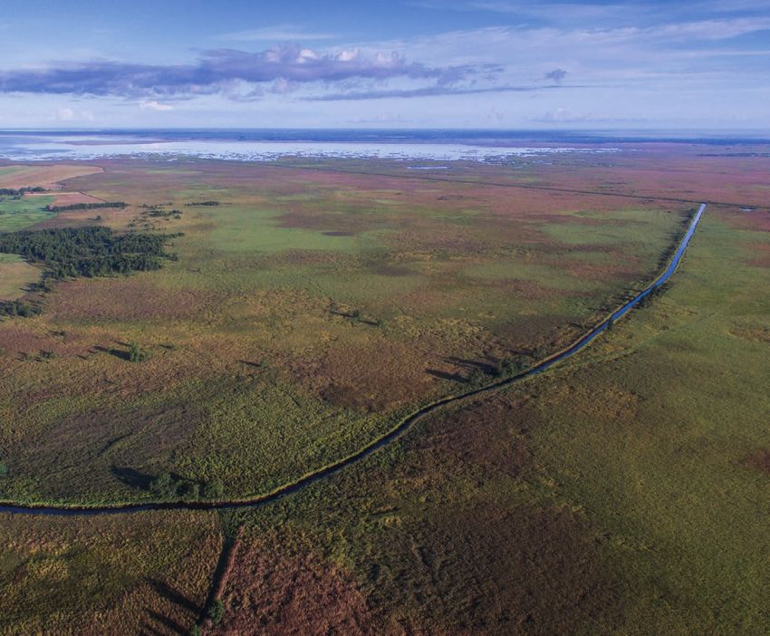
WELCOME TO MATSALU NATIONAL PARK!
    The predecessor of this national park, Matsalu Nature Reserve, was established in
    1957 to protect birds and their nesting, moulting and stopover sites. In 1976, Matsalu
    was added to the List of Wetlands of International Importance, or the Ramsar List. The
    Ramsar Convention recognises nature reserves where wetlands are preserved and
    used sustainably. In 2004, the reserve was given the status of a national park.
    Besides birds, Matsalu National Park aims to protect landscapes characteristic of
    Western Estonia and the cultural heritage of the Väinameri Sea region.
    Matsalu National Park (surface area: 48,610 ha) incorporates the shallow Matsalu
    Bay, some 50 marine islands and islets, the surrounding portion of the Väinameri
    Sea, the delta and tributaries of the Kasari River, reed beds, various semi-natural
    communities and forest stands. A significant part of the national park features man-
    made landscapes (fields, parks, buildings and so on).
    The national park spans the territories of four rural municipalities in Lääne County and
    in terms of management planning is divided into strict nature reserves, conservation
    zones and limited management zones.
    The main sources of livelihood in the area include maintenance of semi-natural
    communities, agriculture, fishing and nature tourism.
    Matsalu National Park has been awarded the European Diploma of Protected Areas by
    the Council of Europe in recognition of its efforts to protect biological, geological and
    landscape diversity in the area.

     Tuudi River, Mati Kose
4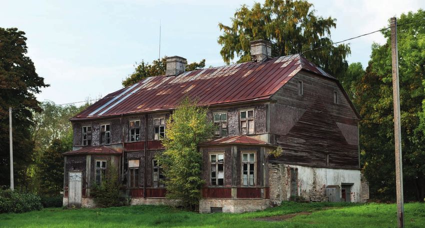
NATURAL VALUES
Meadows
In Matsalu, various types of meadow communities cover some 9,700 hectares. The
most common are flood and coastal meadows. Other types represented in the area are
alvar grasslands, wooded meadows, paludified meadows and dry grasslands.
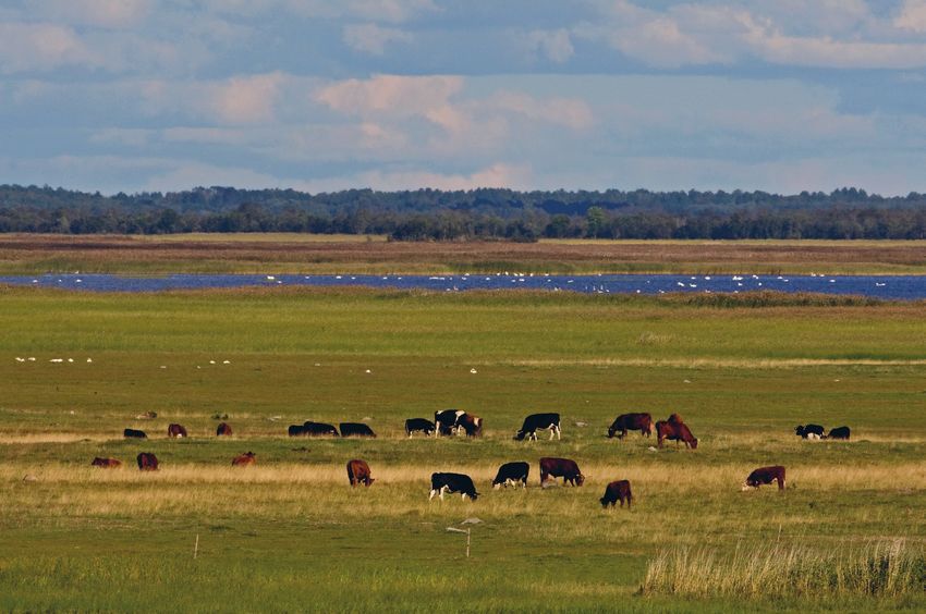
A coastal meadow is an area of grassland which is subject to regular flooding by sea
water and where vegetation is very low-lying due to livestock grazing. Coastal meadows
often feature salt flats and halophilic plants.
In Matsalu National Park, coastal meadows cover approximately 3,000 hectares, being
among the largest of their kind in Europe. The most representative coastal meadows
in Matsalu are those in the village of Haeska on the northern shore of Matsalu Bay,
the Põgari-Sassi coastal meadow by Topu Bay and the Salmi coastal meadow on the
southern shore of Matsalu Bay.
Matsalu’s coastal meadows are among its richest areas in terms of bird life, being
particularly invaluable to Charadriiformes (waders), which need low-lying vegetation,
puddles turned muddy by livestock and an open shoreline. During the migration period,
the community serves as an important feeding and resting place for cranes and geese.
A flood meadow is an area of grassland beside a river which is subject to seasonal
flooding by high waters and generally characterised by high vegetation. Flooded
meadows remain open only when mowed or used for grazing livestock.
The easternmost part of Matsalu National Park is a 4,000-hectare flood meadow – the
largest of its kind in Northern Europe – alongside the Kasari River and its tributaries.
During the spring floods, Kasari’s flood meadow is transformed into an extension of
Matsalu Bay, forming a huge field of water. The high waters typically do not subside for a
couple of weeks until the ice cover in the bay has melted and the floodwater runs off into
the sea. It is interesting to note that this meadow can be flooded as a result of storms
coming in from the west or winds blowing persistently from the same direction, which
can make the river flow backwards. A flooded meadow is an ideal spawning ground for
fish. In spring, this meadow serves as a feeding ground for swans, geese and ducks,
and later, once the water level has subsided, for species in the Tringa genus and the ruff.
Kasari’s flood meadow is also an invaluable nesting site for the corn crake, spotted crake
and great snipe. In summer, roe deer and elk tend to gather in the area, while cranes use
it as a moulting site.
Kasari’s flood meadow, Toomas Tuul
5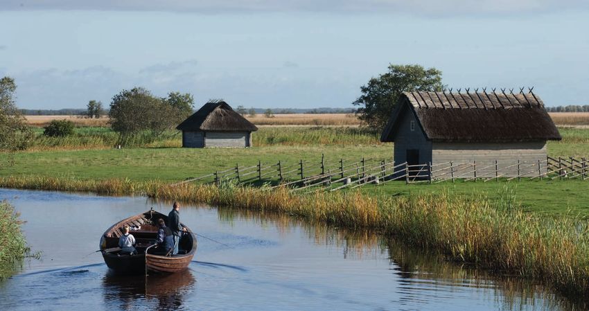
Alvar, Arne Ader

    Wooded meadow, Kaarel Kaisel
6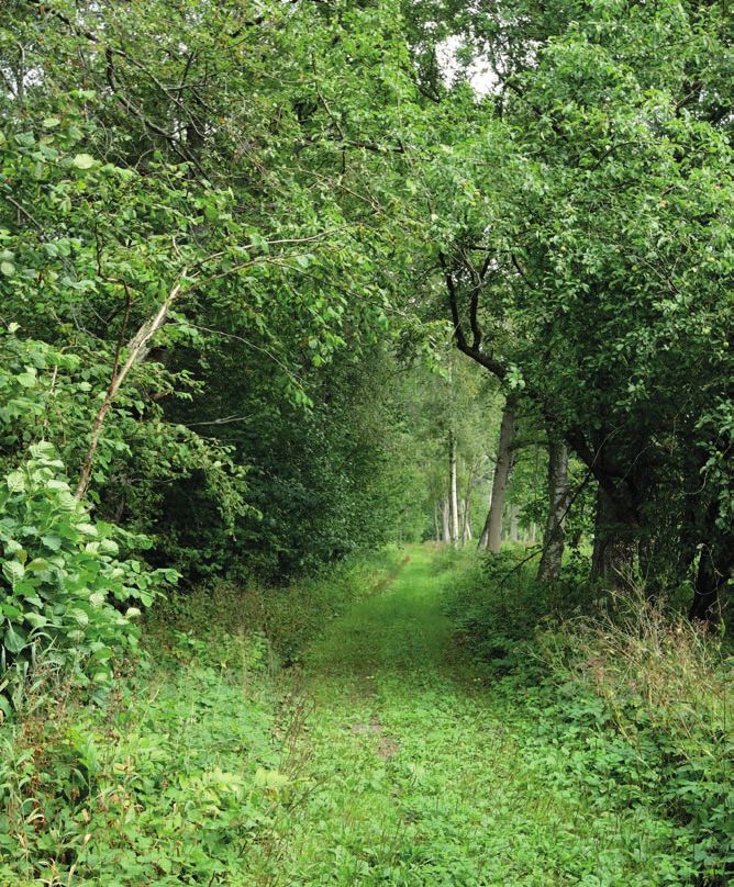
Natural conditions throughout the delta
    were profoundly affected by dredging
    operations carried out in the 1920s and
    1930s with a view to promoting the mowing
    and gathering of hay on flood grasslands.
    To this end, straight channels were dug into
    the lower reaches of the Kasari River and its
    tributaries and extended so as to flow into
    the shallow Matsalu Bay. As a result, high
    waters subside more quickly in the flooded
    meadow and more sediment is carried off
    into the sea.
    An alvar is a dry area of grassland on
    limestone bedrock covered with a thin
    layer of soil. It is characterised by low-lying
    vegetation, but is rich in plant species.
    Alvar grasslands feature shrubs such as
    juniper, hazel, hawthorn and honeysuckle.
    Such open areas dotted with shrubs host
    an unusual mix of bird species, providing
    an abundance of nesting sites (as well
    as a supply of berries and nuts in the
                                                    Fly orchid, Kaarel Kaisel
    autumn). Here you may spot the red-backed
    shrike, barred warbler, common linnet and
    common rosefinch. Alvars can gradually become overgrown – a process which causes
    the loss of their biodiversity. Alvars are quite common in Matsalu. The largest alvar
    grasslands are found in Puise, Rannaküla, Ullaste and Saastna.

    Tree stands and wooded meadows
    Traditionally, the forests in the national park have been used as wooded grasslands
    for mowing or grazing. Wooded meadows are among the plant communities with the
    highest levels of biodiversity. Here over 60 plant species can be found per square
    metre. Due to trees being sparsely scattered in wooded meadows, shade-loving and
    light-loving plants can grow side by side. The surface area of wooded meadows started
    rapidly declining in the 1950s when small-scale wooded grasslands and pastures
    were rendered obsolete by the transition to mass production. Wooded meadows,
    which once took up 4,500 hectares, now cover an area of just 50 hectares. A few
    clearings and lonely trees with broad crowns (typically twisted oaks) growing in the
    middle of forests stand witness to the former extent of wooded meadows. In Matsalu
    National Park the largest wooded meadows are those in Allika, Viita and Kiideva-Puise
    and in Matsalu forest itself. These meadows are home to various orchids, such as
    the common spotted orchid, lesser butterfly orchid, military orchid and early marsh-
    orchid.
    Former wooded grasslands have evolved into boreo-nemoral forests, often found
    alongside the fen and mire forests characteristic of the region. Large, unfragmented
    forest areas include the Puise and Saardo forests on the northern shore of Matsalu
    Bay and the Võigaste and Matsalu forests on the southern shore of the bay. Alluvial
    forests, quite rare in Estonia, can be found in the delta of the Kasari River. These forests
    are very rich in bird species: over a hundred species use them as nesting grounds, and
    the density of bird populations is also exceptionally high. Among the more exotic bird
    species found here are the white-backed woodpecker, black woodpecker, grey-headed
7   woodpecker and Eurasian golden oriole.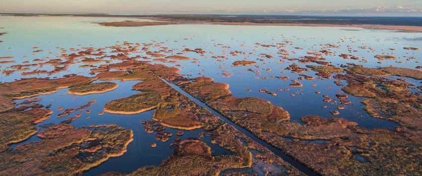
Short-billed dunlin, Kaarel Kaisel             Ruff, Kunter Tätte

    Matsalu Bay, the Väinameri Sea and Islands
    Matsalu Bay is the most important site on the coast of Estonia in which migrating
    ducks, swans, geese and cranes gather. Matsalu is situated on the East Atlantic
    Flyway and more than two million waterfowl pass over the national park annually. Of
    these birds, more than 230,000 stop in Matsalu for longer or shorter periods of time.
    It is the shallow waters and large, well-maintained coastal meadows that attract the
    birds. The largest number of waterfowl and shorebirds flock here in spring (from mid-
    April to mid-May) and in autumn (from September to mid-October).
    Matsalu Bay and the portion of the Väinameri Sea forming part of the National Park
    include around 50 marine islands and islets. The latter are a safe haven for nesting birds
    because of their inaccessibility to predators. Here, the density of bird populations is
    exceptionally high – the islets serve as nesting grounds for the great black-backed gull,
    European herring gull, common gull, common eider, velvet scoter, greylag goose, mute
    swan, tern, Eurasian oystercatcher, common ringed plover and many other bird species.

    Reed beds
    It is estimated that reed beds cover more than 20,000 hectares of Estonia’s territory.
    The largest, approximately 2,000-hectare area of reed beds is located in the delta of the
    Kasari River, on the eastern shore of Matsalu Bay.
    Reed beds are mostly formed from the common reed. In some places they include sea-
    clubrush, reed mace, bulrush and others. Reeds favour shallow waters, but can grow on

     Reed beds in Matsalu Bay, Mati Kose
8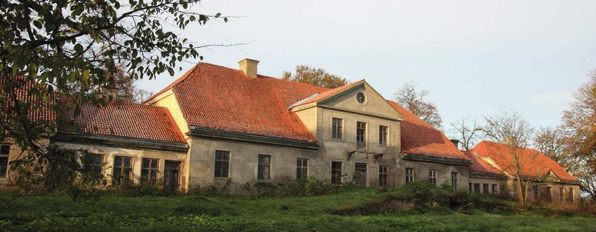
Puise beach, 1926, Source: Haapsalu ja Läänemaa Muuseumid SA

    dry land as well. The portions of reed beds exhibiting the greatest level of biodiversity
    and being otherwise highly valuable are found around pools of open water.
    The reed beds in Matsalu serve as nesting grounds for the Eurasian bittern, Western
    marsh-harrier, greylag goose, great crested grebe, Eurasian coot, spotted crake, water
    rail, Savi’s warbler, great reed warbler and many other birds. In late summer, when ducks
    moult and are unable to fly, the reed beds provide much-needed safety from predators
    and birds of prey. In autumn, large flocks of starlings and swallows use the reed beds
    as a resting site, while in winter they are inhabited by blue tits and lesser spotted
    woodpeckers.
    High walls of reeds are also valued by mammals: elk and wild boar have been seen
    roaming the reed beds, while beavers, otters and American mink have been spotted on
    reeded shores.

    CULTURAL HERITAGE
    Throughout history, the landscapes of Matsalu have been shaped by human activity. In
    ancient times, farmers and those raising livestock readily used dry land that emerged
    from the sea. Over the centuries, human activity has given rise to open cultural
    landscapes and meadows rich in species. Culture as a factor affecting people’s way
    of life also depends on the local natural conditions. Here, landscapes are enriched
    by old stone fences and low-lying farmhouses with thatched roofs made from reeds.
    Livelihoods come from fields, fishing, reed-gathering and crafts.
    To attentive observers, the landscapes here tell many stories of times gone by. Ancient
    hoe-cultivated fields as well as settlements and burial sites are signs of early human
    activity. Slide, healing and sacrificial stones, as well as sacred trees and sites, speak of
    the worldview of former settlers. Remembering old work practices and types of land
    use helps us comprehend the co-existence of man and nature. The main purpose of
    protecting the national park’s cultural heritage is to ensure that we recognise the value
    of human activity, give it meaning and are able to apply it in the modern world.
    Visitors can learn about the region’s cultural heritage at Hanila Museum (which is
    named after August Tampärg), Lihula Museum, Matsalu Nature Centre and Rõude
    Village Hall.
    Traditional methods of farming and raising livestock. In the 20th century, the average
    size of farmsteads on manor estates was around 20 hectares, and there were typically a
    few cows, horses and pigs and up to 10 or so sheep and chickens. Farmers usually grew
9
only enough food to feed themselves and
their families. Fishing provided an additional
food source and the little that may have
been left over from a catch was sold. In
spring, livestock usually grazed on the shore,
after the hay-making period in hayfields and
elsewhere; arable land was used to cultivate
grain, potatoes and flax. Grain was milled
locally, and village landscapes were dotted
with post mills which have since perished.
Modern-day cultural landscapes originate
from the Soviet period, when agriculture
was dominated by collective farms.
Fishing. Matsalu basin, significantly
affected by fresh river water as well as salty
sea water, has provided its inhabitants with
a source of livelihood through fishing in
rivers and reed beds, as well as offshore. In
Floral embroidery characteristic each area, slightly different fishing gear and
of Lääne County, Kaarel Kaisel methods were used.
Crafts. Simpler clothing and everyday items
were typically made locally on farms. For more advanced designs, people would turn to
specialised craftsmen in their own village or in nearby villages. In the southern part of
Lääne County, an abundant heritage of textile items has been preserved – for example,
folk costumes and carpets decorated with floral embroidery, and woven checked
blankets.
Built heritage. All of the manor ensembles in the national park are of different styles
and vary as to the degree they have been preserved. Threshing-room dwellings were
built until World War II and a great number have survived to this day. Similarly to the
farmers who migrated to Matsalu, builders were often from Muhu Island, which is why
older architectural structures sometimes exhibit certain elements characteristic of said
island. Another local feature is using timber from deciduous trees (especially oak) for
making log walls.
Intangible cultural heritage. Also, the oral traditions of the inhabitants of the Matsalu
region require preservation: documented work practices; skills; folk songs and stories;
folklore and myths; place names; and more. This region stands out for its great number
of healing trees and stones as well as natural sites to which a specific meaning was
assigned.
Matsalu Manor, Kaarel Kaisel
10SIGHTS
1 Matsalu Manor was first mentioned in 1560 when it belonged to the order master
of Lihula as an auxiliary manor. In the 1880s, the writer Eduard Bornhöhe (Brunberg)
worked here as a private teacher. The building dates back to the second half of the 19th
century, but may incorporate still older sections. Currently, the manor is privately owned.
2 Metsküla primary school is the only school operating in the national park. Everyone
in the school makes an effort to learn about and preserve natural environment and
cultural heritage.
3 Näärikivid is a protected group of three large erratic boulders. The two larger stones
are over 6 metres across, while the height of the largest stone is almost 2.7 metres.
These boulders are associated with a number of local legends. There is a study trail
leading to the boulders, but it is prohibited to use the trail during the nesting period of
birds (from the breaking up of ice until July 1).
4 Sauemeri and Lake Teorehe. Where Saastna Peninsula joins the mainland there are
two small coastal lagoons − Sauemeri (19.3 ha) and Lake Teorehe (6.8 ha). These are
relics of a strait from when Saastna was an island (the 17th century). Sauemeri is for
the most part overgrown with reeds. Various warblers of the Acrocephalus genus can
be spotted here. The area between the road and the sea is called Lake Teorehe. Due to
livestock grazing, the meadow has low-lying grass cover and serves as an ideal habitat
for birds. When water levels are exceptionally low, both lakes dry up.
5 Saastna Manor was built on Saastna Peninsula in the second half of the 17th
century. In the late 18th century, an impressive main building in the late Baroque style
was erected. The manor was nationalised in 1919. In the 1950s and 1960s the building
fell out of use and into ruin. Later, much of these ruins was demolished. Sadly, a small
corner structure is all that survives to our day of this once-impressive building.
6 Kirikuküla is situated on a gently sloping coastal escarpment. Some 1,000 years
ago, Matsalu Bay reached as far as here. Hundreds of years of livestock grazing have
produced beautiful landscapes which survive to the present day. Old farmhouses with
thatched roofs made from reeds can be seen by the road running alongside the Suitsu
River and elsewhere. Tika farmstead, located in the former village of Äärenurga, is
protected as an architectural monument under the Heritage Conservation Act.
7 Kloostri Manor was established in the Middle Ages as an auxiliary manor to a
Cistercian nunnery. In the early 17th century it came under the ownership of Johann
von Derfelden, who erected a two-storey main building from stone in Baroque style. The
manor survived without major reconstructions until 1939, when the wooden parts of
the building – which by then had fallen out of use – were demolished. Its ruined stone
sections can still be found on the site. The ruins are in danger of collapsing.
Näärikivid, Kaarel Kaisel
118 Memorial stone to Professor Eerik Kumari. A memorial stone dedicated to Eerik
Kumari (born Sits, 1912-1984), an advocate of nature protection and a professor of
ornithology, is located on Kirbla escarpment. Here, as a young boy, Kumari would watch
birds, and these vivid experiences instilled in him a keen interest in the natural world. He
was the first to propose (in 1936) the establishment of a Matsalu bird reserve, but his
suggestion was rejected due to opposition from the hunting community. Since 1989, the
Eerik Kumari Award has been presented annually in recognition of individuals for their
long-term and outstanding contribution to nature protection in Estonia.
9 The Church of St Nicholas in Kirbla was built in the 16th century. It is one of
the smallest stone churches in Estonia (measuring just 30 metres by 11 metres).
Characteristically of Western Estonia, it was built in late Gothic style. Its cemetery
features grave markers dating back to the 18th century. In 2008, the remains of Jüri
Uluots – the last prime minister of the pre-war Republic of Estonia – were reinterred in
the churchyard.
10 Suure-Rõude Manor. The single-storey wooden building in Old Baltic style with its
centrally-placed mantle chimney and hip roof dates back to the 18th century. The manor
is privately owned and used as a dwelling.
11 Rõude cemetery is a burial site with a long history. The oldest stone cross bearing
a date indicates 1460 as the year of burial. There was once a chapel in the middle of
the cemetery; four old lindens grow in its place today. The boundaries of the cemetery
were moved due to road-building operations in the 1950s, during which a mass grave of
plague victims was uncovered.
12 Väike-Rõude Manor was established in the late 16th century. The main building was
most likely erected in the late 18th or early 19th century. The building is unique due to
the majority of rooms on the main storey being decorated with murals. After World War
II the building was converted into flats, but was abandoned in the 1960s because of
extensive dilapidation. The building collapsed in the 1970s. Today, only its side walls
remain standing.
13 Haeska Manor was first mentioned in 1560. Its single-storey limestone main building
was completed in 1805. The building was renovated in 1981 and hosted an exhibition
on the bird species found in the Matsalu reserve. Today, the main building is privately
owned and used as an accommodation establishment.
Kiideva Manor, Toomas Tuul
1214 Kiideva Manor was separated from Haeska Manor in the early 17th century. Its
two-storey main building is thought to date back to the 19th century. The walls of the
building are lined with round-edged wooden shingles reminiscent of fish scales. Such a
technique is very rare in Estonia. The building was last used as a schoolhouse.
15 Põgari chapel was used for the last session of Otto Tief’s government on 22
September 1944. The chapel is still used by Baptists for sermons.
16 Breti’s stones are one of the symbols of Ridala municipality. These were hewn by
Breti (real name: Albert Kallasmaa), a solitary village artist whose life was marked by cruel
twists of fate. The most well-known of the stones is in Puise, by the Kalaspordibaas bus
stop. It bears the text: “Oh, how beautiful a person is when the blood of love flows in his veins.”
17 Memorial stone to Sven Onno. Sven Onno (1932-1974) was an ornithologist who
studied the birds breeding in Matsalu from 1957-1963. It was on his initiative that
studies of the breeding ecology of the common gull, which continue to the present day,
commenced in 1972 in Kakrarahu on Cape Puise. Onno perished in a storm, heading out
to sea unaccompanied to do field work. The memorial stone was erected a year later by
his colleagues.
HIKING IN MATSALU NATIONAL PARK
Hiking trails, observation towers and recreational areas
18 Penijõe Manor – the centre of Matsalu National Park. Penijõe Manor was built in
the early 17th century. The single-storey stone country house was completed in the
early 18th century. In the 19th century the manor was renovated in Classical style: one
wooden storey was added and the middle section of the façade came to have a portico
with four pillars two storeys high.
In the 1930s the manor was owned by the Ministry of Agriculture. A school for crop and
livestock farmers was opened here in 1935. After the school was closed, the manor
served first as the centre of the Lihula state farm and from 1958-1961 as the office
of Matsalu Nature Reserve. Later the building was converted into flats. In 1998, Lihula
municipality donated the manor to the Ministry of the Environment. The building was
renovated in 2000 and is now used as the central offices of the Matsalu protected area.
Penijõe Manor hosts offices of the Environmental Board, the Environment Agency and
the State Forest Management Centre (RMK). The Environment Agency also coordinates
the operations of the Bird Ringing Centre located in the manor. Employees from the
centre organise nature protection, research
and monitoring efforts and promote nature
reserves among the general public. Matsalu
Nature Centre is on the first floor of the
manor. Here visitors can take a look at
an exhibition on the natural values of the
national park. There is also a seminar room
and study room where the Environmental
Board and RMK host nature education
programmes. An outbuilding hosts a
rehabilitation centre for endangered species
where efforts are made to reintroduce
threatened animal and plant species to their
natural environment.
19 Penijõe observation tower and hiking
trail. Penijõe hiking trail starts at the centre Penijõe observation tower, Kaarel Kaisel
13of Matsalu National Park. There are four routes to choose from (measuring 3.6 km,
4.7 km, 6 km and 7 km). There are signposts and information boards along the route,
and additional information is available from Matsalu Nature Centre. The trail has an
8-metre observation tower and a 2.5-metre observation deck. The tower offers excellent
views of reed beds, and on spring evenings you can enjoy the booming calls of the
Eurasian bittern. The trail winds its way through wet meadows and forests and an alvar
grassland. Viita wooded meadow is located on the trail, which goes through an area
used for livestock grazing – you may come upon cows, horses and sheep.
20 Suitsu observation tower and hiking trail. The highest observation tower in Matsalu
(21 metres) is in Suitsu. From here, visitors can enjoy great views over the forest, Matsalu
Bay with reed beds, as well as a flood meadow along the Suitsu River and grasslands.
The trail, which starts from the observation tower and ends in a flood grassland, is an
830-metre boardwalk winding its way through a mire forest of alders. In the grassland
is a renovated hay barn. Here, on the fringes of a flood grassland, you can spot the
Eurasian woodcock or common snipe. The bog violet, a protected species, blooms in
early May in the mire forest of alders at the start of the trail.
21 Kloostri observation tower. The 16-metre Kloostri observation tower is an excellent
spot to gain an overview of the extent of the communities found in flood plain meadows.
The tower offers the most impressive views during the season of spring high waters,
which take a couple of weeks to subside. During this period you should be prepared to
wade through the water to get to the tower. The observation tower is also worth visiting
in late summer and autumn, when you can see roe deer and elk.
22 Keemu observation tower. The 6-metre observation tower located next to Keemu’s
harbour offers views over the islets in the centre of Matsalu Bay and the shallow
middle part of the bay with its reed beds and coastal meadows. For those interested
in ornithology, there are exciting species to watch from early spring through to late
autumn, when ice cover starts to form. In spring, swans, waders, ducks and geese flock
to Matsalu Bay. In summer, more exciting aspects of bird life converge on the small
islands off the coast. From September, the corners of Matsalu Bay once again fill with
geese, cranes and ducks. By the tower there is also a village square with a large swing.
23 Salevere hiking trail. This 1.5-kilometre trail winds its way through an alvar grassland
and a broad-leaved boreo-nemoral forest growing along a 5-metre escarpment. At the
foot of the escarpment is a klint forest and Silmaallikas (Eye Spring). According to legend,
washing your eyes with water from the spring at midnight on Midsummer will restore
Salumägi Hill, Toomas Tuul Silmaallikas (Eye Spring), Kaarel Kaisel
14vision even to the blind. Also, on Salumägi
Hill you can take a look at the remains of
ancient fortifications, and at another point
on the trail you will spot a low-lying bulwark.
24 Rannajõe observation tower. This
4-metre observation tower in Rannajõe is
accessible to wheelchair users. Great views
over a flood meadow open up from the
tower. The best time to visit is during the
spring floods and in autumn, i.e. September
and October. Here you can watch cranes
and geese passing overhead as well as wild
animals roaming the flood meadow.
25 Haeska observation tower. Haeska
observation tower (10 metres) offers
excellent views over a coastal meadow and
most of the inner part of Matsalu Bay. For
those interested in ornithology, the best Kiideva hiking trail, Kaarel Kaisel
time to visit is in April and May or September
and October, because these are the migratory stopover periods when birds abound here.
However, summer is also a good time to watch birds and enjoy the views over the well-
maintained coastal meadow. Nearby are two islands – known as Haeska rahud – where
people once used to make hay. The tower is privately owned, but open to the public.
26 Kiideva observation tower and hiking trail. This observation tower and hiking trail
were constructed on the initiative of locals. Cape Puise and Matsalu Bay can be seen
from the harbour building and observation deck in Kalaküla. The hiking trail (5 km)
follows an old wagon road between the villages of Kiideva and Puise. The trail winds its
way through a boreo-nemoral forest and a restored wooded meadow. Halfway along the
trail in Nurga is a restored hay barn where visitors can take a break. The trail ends at the
Lõpre Oak, which is the oldest tree in the area.
Hiking routes
The best starting point is Penijõe Manor, where you can obtain additional informa-
tion on various routes from the RMK information centre. The following routes include
observation towers and hiking trails owned by the RMK as well as others that are
privately owned, but open to the public. For each route, the indicated distance includes
visits to all of the objects given in the description.
Penijõe and surroundings (ca 17 km).
Penijõe Manor and Matsalu Nature Centre, Kloostri Manor and observation tower,
Penijõe hiking trail and observation tower, Viita wooded meadow, Kirikuküla village
and Suitsu observation tower and hiking trail.
Southern shore of Matsalu Bay and Salevere (ca 23 km)
Matsalu Manor, Keemu observation tower, Metsküla village, Näärikivid boulders,
Saastna, Lake Teorehe and Sauemeri and Salevere.
Northern shore of Matsalu Bay (ca 79 km).
Kirbla escarpment, Kirbla church, Suure-Rõude Manor, Rõude cemetery, Väike-Rõude
Manor, Rannajõe tower, Haeska Manor and observation tower, Kiideva Manor and
observation tower, Kiideva-Puise hiking trail, Põgari, Breti’s stones and memorial stone
to Sven Onno.
15INSTRUCTIONS FOR VISITORS
Please note:
••You are in a national park. Familiarise yourself with the conservation rules of the
protected area prior to visiting it.
••In conservation zones with restrictions on movement, moving around is only allowed
with the permission of the manager of the protected area.
••When driving a motor vehicle, use the designated roads and car parks only.
••Moving around on private land is regulated by the Law of Property Act and the Nature
Protection Act.
••Camping and making fires is allowed in specially arranged and designated places only.
Camping and making fires in home yards is allowed with the permission of the owner.
••Fishing is only allowed in the territory of the national park with a fishing permit, which
also serves as a permit to access the fishing areas designated thereon.
Hiking trails may run through grazing areas. As such:
••do not disturb the livestock;
••use the specially arranged places or crossings to pass grazing enclosures (if these do
not exist, make sure you close all gates);
••keep dogs on a leash when in the national park and do not bring dogs onto trails
crossing grazing land.
Upon leaving:
••do not leave any garbage behind – take it with you and place it in a garbage bin.
For additional information on the nature and cultural heritage of the national park, go to:
••www.matsalu.ee
••www.loodusegakoos.ee
If you become aware of activities that are potentially harmful to the environment or
visitor facilities, call the Environmental Inspectorate hotline on 1313
For emergency services, call 112
The following source has been used:
Valker, M. (2014). Matsalu teejuht. [Manuscript].
Suitsu River, Toomas Tuul
16Did you know? ••The nature reserve, established in 1957, was given the status of a national park in 2004. ••The national park’s surface area is 48,610 ha. ••The national park was established to protect birds and their nesting, moulting and stopover sites as well as landscapes characteristic of Western Estonia and the cultural heritage of the Väinameri Sea region. ••More than 780 species of vascular plants, 280 species of birds and 40 species of mammals as well as five species of amphibians and four species of reptiles have been recorded here. ••Rare species include the frog orchid, natterjack toad, short-billed dunlin, ruff, white-tailed eagle, Eurasian eagle-owl and lesser white-fronted goose. ••Matsalu is one of the most important nesting and stopover sites for waterfowl in Europe. ••In 2013, the first sighting of a jackal in Estonia was documented in the National Park.
You can also read