Migration ecology of western gray catbirds
←
→
Page content transcription
If your browser does not render page correctly, please read the page content below
Mancuso et al. Movement Ecology (2021) 9:10
https://doi.org/10.1186/s40462-021-00249-7
RESEARCH Open Access
Migration ecology of western gray catbirds
Kristen A. Mancuso1* , Megan A. Fylling2, Christine A. Bishop3, Karen E. Hodges1,
Michael B. Lancaster4 and Katharine R. Stone5
Abstract
Background: For many songbirds in North America, we lack movement details about the full annual cycle, notably
outside the breeding season. Understanding how populations are linked spatially between breeding and
overwintering periods (migratory connectivity) is crucial to songbird conservation and management. We assessed
migratory connectivity for 2 breeding populations of Gray Catbirds (Dumetella carolinensis) west of and within the
Rocky Mountains by determining migration routes, stopover sites, and overwintering locations. Additionally, we
compared apparent annual survivorship for both populations.
Methods: We deployed 39 archival light-level geolocators and 21 Global Positioning System (GPS) tags on catbirds
in the South Okanagan Valley, British Columbia, Canada, and 32 geolocators and 52 GPS tags in the Bitterroot River
Valley, Montana, USA. These devices allowed us to determine migration routes, stopover sites, overwintering
locations, and migratory connectivity. Migratory connectivity was quantified using Mantel’s correlation. We used
mark-recapture of colour banded catbirds in both sites to estimate apparent annual survivorship.
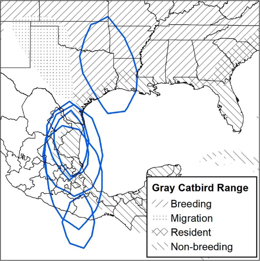
Results: We retrieved 6 geolocators and 19 GPS tags with usable data. Gray Catbirds from both populations passed
through the Rocky Mountains eastward before heading south towards their overwintering locations in northeastern
Mexico and Texas. Stopover sites during fall migration occurred primarily in Montana, Kansas, Oklahoma, and
Arkansas. Overwintering locations spanned Texas and 5 states in northeastern Mexico. Individual catbirds used up
to 4 distinct sites during the overwintering period. Catbirds separated by almost 500 km during the breeding
season overlapped during the non-breeding season, suggesting weak migratory connectivity among western
populations (Mantel’s correlation = 0.013, P-value = 0.41). Catbird apparent annual survivorship estimates were
higher in British Columbia (0.61 ± 0.06 females; 0.64 ± 0.05 males) than in Montana (0.34 ± 0.05 females; 0.43 ± 0.04
males), though the main driver of these differences remain unclear.
Conclusions: Our results provide high precision geographic details during the breeding, migration, and
overwintering phases of the annual cycle for western Gray Catbirds. Notably, we found that western catbirds
followed the Central Flyway as opposed to the Pacific Flyway. We document that catbirds used multiple sites over
winter, contrary to the popular belief that this phase of the annual cycle is stationary for most songbirds.
Keywords: Dumetella carolinensis, Full annual cycle, Migration, Migratory connectivity, GPS tracking
* Correspondence: kmancuso88@gmail.com
1
Department of Biology, University of British Columbia Okanagan, Kelowna,
British Columbia, Canada
Full list of author information is available at the end of the article
© The Author(s). 2021 Open Access This article is licensed under a Creative Commons Attribution 4.0 International License,
which permits use, sharing, adaptation, distribution and reproduction in any medium or format, as long as you give
appropriate credit to the original author(s) and the source, provide a link to the Creative Commons licence, and indicate if
changes were made. The images or other third party material in this article are included in the article's Creative Commons
licence, unless indicated otherwise in a credit line to the material. If material is not included in the article's Creative Commons
licence and your intended use is not permitted by statutory regulation or exceeds the permitted use, you will need to obtain
permission directly from the copyright holder. To view a copy of this licence, visit http://creativecommons.org/licenses/by/4.0/.
The Creative Commons Public Domain Dedication waiver (http://creativecommons.org/publicdomain/zero/1.0/) applies to the
data made available in this article, unless otherwise stated in a credit line to the data.
Mancuso et al. Movement Ecology   (2021) 9:10                                                                 Page 2 of 16

Background                                                   Louisiana, eastern Mexico, and Central America [14]. In
The decline of North American songbirds is a conserva-       the eastern and central portion of the breeding range,
tion concern in the Anthropocene [1, 2]. There are           Ryder et al. [13] found catbirds breeding in the mid-
major knowledge gaps in the ecology of most migratory        Atlantic overwintered in Cuba and Florida, and those
bird species, with deficits evident especially during mi-    breeding in the Midwest overwintered in Central Amer-
gration and winter because most research is focused on       ica. Likewise, stopover ecology is limited to eastern pop-
breeding birds [2–5]. The link through space and time        ulations; one mark-recapture study in coastal Alabama
between breeding and overwintering periods is import-        during fall migration reported adult catbirds stayed on
ant to address, in part because the effects in one season    average for 4.1 days before departure [15].
can influence events in another season, such as habitat        The migration ecology of western Gray Catbirds, in-
quality influencing body condition and migration timing      cluding how they travel through or around the Rocky
[5, 6]. The full annual cycle of migrant songbirds gener-    Mountain Range, remains unexplored. Most migratory
ally includes breeding, fall migration, overwintering, and   birds breeding west of the mountains migrate using the
spring migration. To identify potential threats through-     Pacific Flyway, whereas most birds east of the mountains
out the annual cycle, it is important to understand          follow the Central Flyway [16–19]. However, studies
where, when, and how long a bird is present at each          from central and coastal British Columbia tracked
stage of the cycle [7, 8].                                   breeding Veeries (Catharus fuscescens) and Swainson’s
  Conservation and management efforts for songbirds          Thrushes (C. ustulatus) across the Rocky Mountains to
require an understanding of how populations are geo-         the Central Flyway towards overwintering sites in South
graphically linked through different phases of the annual    America [20–22]. In 1964, it was postulated that western
cycle – a concept termed migratory connectivity [7, 9].      Gray Catbirds may migrate east before heading south,
Individuals from populations of species with strong mi-      implying that these birds have to cross the Rocky Moun-
gratory connectivity show minimal geographic spread          tains [23]. Similarly, the analyses of stable hydrogen iso-
and little overlap with other populations through differ-    tope ratios of catbird feathers linked overwintering birds
ent phases of the annual cycle, whereas individuals from     in Mexico to inferred breeding sites located in the
populations of species with weak migratory connectivity      northwestern part of their breeding range [24].
show greater geographic spread and may co-occur with           The goals of our research on Gray Catbirds were to:
individuals from different populations [7, 9]. Conse-        (1) track migration routes; (2) identify stopover sites; (3)
quently, a threat on the overwintering grounds may have      determine overwintering locations; (4) assess migratory
diffuse effects among multiple populations if weak mi-       connectivity; and (5) compare apparent survivorship for
gratory connectivity exists [7, 10]. However, it may be      populations breeding in western Montana, USA, and
more challenging to implement effective conservation         southern British Columbia, Canada. Our research will
strategies across the annual cycle for populations with      verify whether western Gray Catbirds migrate using the
weak migratory connectivity.                                 Pacific Flyway or the Central Flyway. In addition, we will
  In addition to studying population-level characteristics   advance our understanding of the full annual cycle of
of a species, apparent annual survivorship is a valuable     western catbird populations and their migration ecology
demographic rate because it can indicate the health of a     which may help ensure this species remains abundant
population, life cycle stages at risk, and identify high-    on the landscape.
quality habitat [11, 12]. Survivorship is sensitive to
short-term and local environmental changes and, there-       Methods
fore, can help elucidate the underlying mechanisms to        Study areas
changes in population size [11, 12]. However, robust an-     We examined breeding Gray Catbirds in two locations:
nual survivorship estimates can be challenging to obtain     (1) the South Okanagan Valley, British Columbia,
as they require multiple years of data on marked             Canada (49.200° N, 119.552° W), and (2) the Bitterroot
individuals.                                                 River Valley, Montana, USA (46.668° N, 114.023° W).
  In this study, we examined the migration behaviour         These two study areas were 495 km apart, with the Brit-
and estimated apparent annual survivorship of Gray Cat-      ish Columbia population occurring west of the Rocky
birds (Dumetella carolinensis) breeding west of and          Mountains and the Montana population occurring
within the Rocky Mountain Range. Gray Catbirds are           within the Rocky Mountains. Catbirds were locally abun-
the only species within the Mimidae family whose mi-         dant in both study sites.
gratory behaviour has been studied in detail but only in
the eastern portion of its extensive North American          Tracking devices
range [13]. The known overwintering range of Gray Cat-       Gray Catbirds were captured in mist-nets passively or
birds includes Florida, southeastern Texas, southeastern     with the aid of call-playback in the breeding seasons
Mancuso et al. Movement Ecology   (2021) 9:10                                                                 Page 3 of 16

from 2013 to 2018. Each bird was given a standard              scheduled fix, however, in all cases should be better than
USGS band and a unique combination of colour-bands             300 m [33]. We tested the GPS tags before deployment
to aid in future identification. Birds were aged and sexed     in British Columbia at a stationary location and found
according to Pyle (1997) [25]. Adult male and female           that 90% of the points were within 100 m of the test lo-
catbirds were outfitted with an M-Series light-level geo-      cation, and many within a few meters. GPS tags were
locator, Lotek, Newmarket, Canada (mass between 0.3–           pre-programmed to obtain GPS coordinates at specific
1.0 g, hereafter “geolocator”) or PinPoint GPS tag, Lotek,     dates, which varied by location and year but generally
Newmarket, Canada, (mass 1.0 g, hereafter “GPS tag”            were 1–5 days apart during migration and 10–30 days
[26, 27]). Geolocators were used only to infer general         apart during winter.
movement patterns whereas GPS tags were used for
movement patterns plus quantitative analyses.                  Repeat tracking
   Tracking devices were fitted onto birds by creating a       Three Montana birds were tracked in multiple years
leg-loop harness which allowed the device to sit on the        with separate devices. One female catbird was given a
lower back of the bird, an optimal position for sunlight       geolocator in 2012, another geolocator in 2013, and a
and satellite communication [28]. The harness was made         GPS tag in 2014. One male catbird was given a geoloca-
of Stretch Magic jewelry cord manufactured by Pepperell        tor in 2013 and a GPS tag in 2014. Another male catbird
Braiding Company, MA. Stretch Magic is an elastic-like,        was given a GPS tag in 2016 and another GPS tag in
transparent, monofilament made of polyurethane and             2017.
polyester and was ideal for accommodating fluctuations
in size throughout the year. The harnesses were closed         Analyses of tracking devices
either by using a crimp bead or melting with a soldering       Geolocator files (.lig) were downloaded and light data
iron, allowing harnesses to be custom fit to birds of          were processed using R (v 3.5.1 [35]). Methods for the
varying sizes. Throughout the project, we checked recap-       analyses of the geolocators followed Lisovski et al.
tured birds for any sign of wear, abrasion, or feather loss    (2020) [36]. We used the GeoLight (v. 2.0.1 [37]),
and found minimal undesirable effects, however, some           TwGeos (v.0.1.2 [38]), and adehabitatHR (v. 0.4.16 [39])
birds had evidence of light chafing on their thighs. Har-      packages. Twilights were determined using the prepro-
nesses were durable and we had no instances of birds           cessLight function in the TwGeos package using a
losing their geolocators or GPS tags with this method.         threshold value of 0.5 because there did not appear to be
This technique was adopted from other researchers who          any nighttime light interference. Twilights were edited
used the method successfully for attaching geolocators         using the twilightEdit function from the TwGeos pack-
to songbirds [29, 30].                                         age (with ‘window’ set to 4, ‘outlier.mins’ set to 45, and
   The average mass of Gray Catbirds was 36.3 g, there-        ‘stationary.mins’ set to 25). Overwintering dates were de-
fore, tracking devices were < 3% of body mass, which is        fined as November 15 – March 1 to avoid the equinox
the preferred maximum for tracking birds and within            by 3 weeks and to include times when birds would be on
the < 5% recommendation by animal care committee               their wintering grounds [40]. The Hill-Ekstrom method
standards [31, 32]. Due to the small size of the devices,      was used to determine the sun elevation angle during
the number of GPS fixes were limited, with up to 8 fixes       winter months using the findHEZenith function from
advertised for PinPoint-8 tags, up 10 fixes advertised for     the TwGeos package [41, 42]. The Hill-Ekstrom method
PinPoint-10 tags, and up to 80 fixes advertised for Swift      determines the correct sun elevation angle for stationary
PinPoint-10 tags [33]. Devices were retrieved in subse-        periods at unknown locations by determining a sun ele-
quent breeding seasons by targeting individuals identi-        vation angle that minimizes variance in latitude esti-
fied by their unique colour-band combination. Captured         mates [43]. Winter latitude and longitude estimates were
birds had the harness and device removed then released         calculated using the coord function of Geolight. To
unharmed. We deployed 39 geolocators and 21 GPS tags           summarize the overwintering locations used by Gray
in British Columbia, and 32 geolocators and 52 GPS de-         Catbirds, 50% Kernel Density estimates were calculated
vices in Montana.                                              from coordinates using the kernelUD function from the
   The average accuracy (± standard deviation) of the M-       adehabitatHR package. A shapefile compatible with Arc-
Series geolocator is 185 (±115) km, but many factors           Map 10.7.1 [44] was created by using the getverticeshr
may affect the accuracy of geolocators, including shad-        function.
ing, clouds, sensor degradation, and artificial lights [34].      The location coordinates from the GPS tags were vet-
The shrubby riparian habitat inhabited by Gray Catbirds        ted by removing points that had low accuracy, defined as
may be an additional source of shade and further limit         those with dilution of precision values greater than 20
geolocator accuracy. The accuracy of GPS tags varies de-       [33]. The remaining points were plotted using Arc-
pending on the number of satellites available during a         Map 10.7.1. Points were connected to create migration
Mancuso et al. Movement Ecology   (2021) 9:10                                                                Page 4 of 16

tracks and to calculate distances, although we caution        Apparent annual survivorship
that these straight-line paths are our best approximation     We included both recaptured and resighted birds in our
of migration route as the exact path is unknown. We de-       apparent annual survivorship analyses. In British
fined stopover sites as locations with 2 or more consecu-     Columbia, the data set spanned 2015 to 2019 and a total
tive fixes during migration outside of the mapped non-        of 537 birds were colour-banded. Two study sites in
breeding range in September and early October. GPS            British Columbia were used and effort included (1) inter-
fixes were programmed to be taken between 1 and 5             mittent target and passive mist-netting in conjunction
days apart, therefore, the minimum stationary period          with deploying and retrieving tracking devices; and (2) a
during migration that we considered a stopover was 24         standardized approach. Target and passive netting in-
h. Overwintering locations were defined as the first sta-     volved setting up 1–8 nets from before sunrise to early
tionary period of consecutive fixes in the known over-        afternoon at the latest and occurred intermittently (~ 1–
wintering range. However, for the older generation GPS        3 times a week) between May–August. Concurrently, 1–
tags where 8 or fewer fixes were obtained, we assume          3 biologists searched for birds using binoculars and con-
that the points occurring from mid-October onwards            firmed colour-band combinations using high-zoom
correspond to overwintering locations, as most GPS-           digital cameras or binoculars. Effort was increased dur-
tagged birds from both sites had reached their overwin-       ing the last year of the study in 2019, where at least 5
tering locations by early October based on the later          days a week, catbirds were resighted or recaptured from
model Swift GPS tags. To visualize potential travel           the end of May to early July. The standardized approach
routes around or within the Rocky Mountains, tracks           occurred once a week between May 1–September 15
and points were overlaid on a 30 arc-second digital ele-      using 10 mist-nets in a fixed location for 6 h and oc-
vation model of North America in ArcMap 10.7.1 [44].          curred in the first site only.
To better contextualize habitat and elevation at stopover        In Montana, the dataset spanned 2006 to 2018 and a
locations and overwintering locations, we overlaid satel-     total of 741 catbirds were colour-banded. Two study
lite imagery using ArcMap 10.7.1 for each catbird during      sites in Montana were used and effort included (1) inter-
stopovers and in the non-breeding period.                     mittent target and passive mist-netting in conjunction
                                                              with deploying and retrieving tracking devices; (2) a
Migratory connectivity                                        standardized approach, (3) intermittent banding for edu-
Migratory connectivity was quantified with a Mantel’s         cational purposes (5 days total). Target and passive net-
correlation (rM) which involves comparing two matrices        ting included 1–3 technicians working most weekdays
and their random permutations [45]. A significant posi-       between May 25–July 15 from sunrise to approximately
tive correlation in the distances between breeding indi-      11:30 AM to resight and target net colour-banded cat-
viduals and overwintering individuals suggests strong         birds between 2012 and 2018 at the first site only. Stan-
migratory connectivity [46]. Our matrices included (1)        dardized MAPS banding efforts occurred from 2011 to
the geographic distances between all individuals on the       2018 at the first site and 2006–2018 at the second site
breeding ground and (2) the geographic distances be-          and involved 10 mist nets open 6 h a day for 7 sample
tween all individuals on the overwintering grounds. Be-       periods during the breeding season [49]. Educational
cause some catbirds moved around during the                   banding occurred only at the second site.
overwintering period and we did not have data for the            Apparent annual survivorship was calculated using
full overwintering period for all birds, we used the first    RMark (v. 2.2.7 [50]) in R. Cormack-Jolly-Seber models
overwintering location for the second matrix. Note that       [51, 52] were used, which included the apparent annual
only geographic locations from GPS tags were included         survivorship (ϕ) and detection probability (p) as model
in the distance matrices and not locations obtained by        parameters. Assumptions of Cormack-Jolly-Seber
geolocators due to the inherent low precision associated      models are that (1) every bird has the same probability
with geolocators. Matrices were created using the r.dis-      of being recaptured/resighted at the next sampling
t.earth function of the fields package (v.9.8.6 [47]) in R.   period; (2) every bird has the same probability of surviv-
The Mantel correlation coefficient was calculated using       ing to the next sample period; (3) Colour-bands are not
the mantel.rtest function of the ade4 package (v.1.7.13       lost or missed, and; (4) sampling time is short (or in-
[48]). A P-value associated with the correlation coeffi-      stantaneous) relative to the interval in between sampling
cient was calculated based on 9999 random permuta-            times. To assess the goodness-of-fit of our data to the
tions. In addition to Mantel’s correlation, we calculated     assumptions of Cormack-Jolly-Seber models, we used
the average pairwise distances between all individuals        the program RELEASE via RMark using the function
within the breeding and overwintering locations separ-        ‘release.gof’. Goodness-of-fit was assessed by examining
ately for Montana and British Columbia birds to quan-         the fit of the global model. Because we were comparing
tify the geographic spread of each population.                the fit of multiple models with varying parameters, we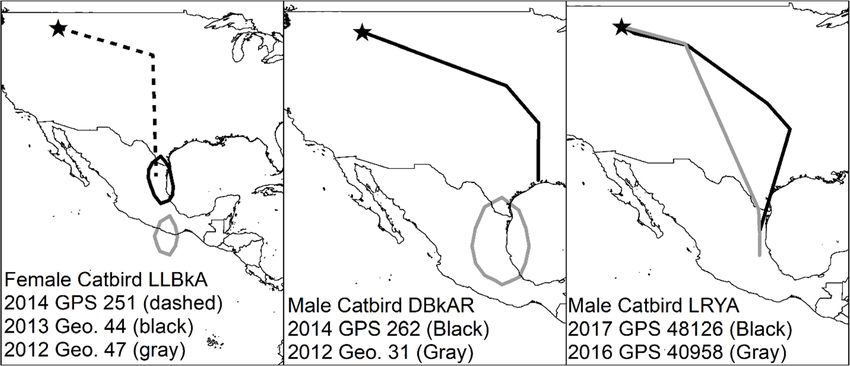
Mancuso et al. Movement Ecology   (2021) 9:10                                                                 Page 5 of 16

used the model with the highest number of parameters         Migration routes
as the global model, which contained sex as a covariate.     The migration route identified from GPS tags showed
There was no evidence of a lack of fit of the global         catbirds from Montana and British Columbia heading
model to Cormack-Jolly-Seber model assumptions (χ2 =         east across the Rocky Mountain Range, then south to-
27.35, df = 25, P-value = 0.34).                             wards overwintering locations in Mexico and Texas
   Birds of all ages (except nestlings) were used in the     (Fig. 1). While navigating the Rocky Mountain Range,
analyses. Sex was included as a covariate for both sur-      Gray Catbirds from British Columbia appear to have
vivorship and detection. To account for potential local      traveled through lower elevation corridors; the elevation
differences between sites within each study area, site was   of points occurring within the Rocky Mountain
included as a covariate. Because the first encounter is      Range were 1939, 849, 1020, 917, 497, 392, 662, 886,
likely to include young or transient birds who are           and 1034 m whereas the mountainous peaks within
more likely to permanently leave the study area              British Columbia, Washington, Idaho, and reach
through death or immigration and thereby have a              heights > 3000 m above sea level (Fig. 1). The fixes
lower apparent annual survivorship in this first year        for Montana Gray Catbirds occurred too far east of
after being colour-banded, we included a time-since-         the Rocky Mountain Range to assess their specific
marking covariate where the first encounter is sepa-         paths through the mountains.
rated from subsequent encounters [53, 54]. Multiple            In 5 cases from Montana, we have at least part of the
models that contained different combinations of co-          spring migration route. These birds followed the same
variates were compared using an Akaike Information           general routes in fall and spring (Fig. 2). Migration speed
Criteria (AIC) approach adjusted for small sample            averaged 113 km/day and we saw no difference between
sizes (Table 1, Burnham and Anderson 2002). We               spring and fall (t = − 1.3, df = 10, P-value = 0.24, 95% CI:
considered models with ΔAICc values of less than 2           − 43.7, 12.2; Table 1). No spring migration data was
to have substantial support [55]. We also calculated         available from British Columbia catbirds due to GPS tag
AICc weight and considered any model with a weight           battery exhaustion.
of greater than 0.90 as a clear top model [55]. For all
analyses, mean and standard error are reported unless        Stopover sites
otherwise noted.                                             We identified 20 fall stopover sites and one spring stop-
                                                             over site from our two catbird populations combined
                                                             (Fig. 3). None of the tagged Gray Catbirds stopped at
Results                                                      the same stopover site, and the closest sites were 24.7
In British Columbia, the return rate of birds with           km apart. Stopover sites for British Columbia Gray Cat-
geolocators was 8 out of 39 (20.5%), and 7 geoloca-          birds were in Montana, Kansas, Oklahoma, Missouri,
tors were retrieved. The return rate of catbirds with        and Arkansas (Fig. 3). Stopover sites for Montana Gray
GPS tags was 6 out of 20 (30.0%), excluding one de-          Catbirds were in Kansas, Oklahoma, and Arkansas. The
ceased catbird found in the same year of deployment.         amount of time spent at each stopover site ranged be-
All 6 GPS tags were retrieved. We experienced poor           tween 1 to 16 days, but our estimate of stopover dur-
performance in the geolocator technology. One geo-           ation is limited by the sampling interval of the GPS tag
locator had light data for only 2 months, but all            ranging from 1 to 5 days during migration. From satellite
other geolocators contained data for the full year.          imagery, stopover habitat generally included patches of
Light levels recorded on the geolocators were low            trees or shrubby habitat, often within 500 m to water
and inconsistent, making the determinations on sun-          (satellite imagery of stopover sites can be found in add-
rises and sunsets spurious (an example of low-quality        itional file 2). The exception to the pattern of riparian
geolocator data can be found in additional file 1). All      habitat use was one stopover in an urban environment.
location estimates were severely outside known over-         The elevation of stopover sites varied widely, from 74 to
wintering distributions (examples of erroneous loca-         1060 m above sea level.
tion estimates can be found in additional file 1). All
GPS tags contained data but fewer than the adver-            Overwinter sites
tised maximum number of 80 fixes.                            Gray Catbirds that bred in British Columbia and Mon-
   In Montana, the return rate of birds with geolocators     tana had overlapping overwintering areas in Texas and
was 10 out of 32 (31.3%), and 6 geolocators were re-         Mexico. Gray Catbirds breeding in British Columbia
trieved. The return rate of catbirds with GPS tags was       overwintered in Texas, Tamaulipas, San Luis Potosi, Hi-
18 out of 52 (34.6%), and 14 GPS tags were retrieved.        dalgo, and Nuevo Leon, Mexico (Fig. 4 and Table 2).
All geolocators contained usable data, but 2 GPS tags        Gray Catbirds breeding in Montana overwintered in
did not contain usable data.                                 Texas, San Luis Potosi, Tamaulipas, Veracruz, Puebla,
Mancuso et al. Movement Ecology (2021) 9:10 Page 6 of 16
Table 1 Movement summary of Gray Catbirds (Dumetella carolinensis) fitted with GPS tags
Fall Spring
Tag ID Bird ID Sex Year Fix Loc. Depart Arrive Length Distance Speed Depart Arrive Length Distance Speed
(Days) (km) (km/ (Days) (km) (km/day)
day)
British Columbia
YRGX M 2017 23 NLE Sep 6 Oct 36 3905 108 – – – – –
42000 12
YROX M 2017 53 TX Sep 10 Oct 32 3236 101 – – – – –
42005 12
BBRX M 2018 46 SLP Sep 10 Oct 36 4686 130 – – – – –
48964 16
BBXB M 2018 48 TAM Sep 12 Oct 32 4098 128 – – – – –
48961 14
BBYX M 2018 51 TAM, SLP, Sep 16 Oct 36 4171 116 – – – – –
48965 HID 22
BBXD F 2018 28 TAM* Sep 6 Oct 40 4192 105 – – – – –
48963 16
Mean ± SE 35 ± 1.2 4048 ± 115 ±
193.5 4.9
Montana
251 LLBkA F 2014 3 TAM – Dec 7 – 3235 – – – – – –
262 DBkAR M 2014 4 TX – Dec 7 – 2746 – – – – – –
245 RAWW M 2014 2 TAM – Jan 7 – 3507 – – – – – –
LRYA M 2016 8 TAM, HID – Oct – 3072 – – – – – –
40958 18
LRYA M 2017 38 TAM, Sep 14 Oct 35 3390 97 Apr 26 May 35 3501 100
48126 HID 19 31
ODAS M 2017 41 TAM, VER, Sep 9 Oct 33 3358 102 May 3 May 28 3424 122
48120 HID 14 31
OOAS F 2017 22 VER Sep 4 Oct 55 3911 71 – – – – –
48121 29
DOGA F 2017 36 TAM, HID Sep 9 Oct 35 3579 102 Apr 26 May 28 3764 134
48123 14 24
GOAS F 2017 40 TAM, VER Sep 19 Oct 30 3407 114 May 3 May 28 3677 131
48124 19 31
WWAS M 2017 36 TAM, SLP, Sep 9 Oct 35 4032 115 – – – – –
48131 VER 14
RLGA F 2017 37 TAM, PUE Sep 9 Oct 35 3401 97 May 3 – – – –
48133 14
ADBkW M 2017 37 VER, HID Sep 9 Oct 4 25 3760 150
48134
Mean ± SE** 35 ± 3.2 3604 ± 106 ± 29 ± 2 3591 ± 78 122 ± 7.7
76.2 7.8
*Last fix on October 16, assuming overwintering site but could potentially still be on migration
**Mean (± Standard Error) but not including length or speed for units with less than 10 fixes
Summary of GPS tags attached to Gray Catbirds in the South Okanagan Valley, British Columbia, Canada, and in the Bitterroot River Valley, Montana, USA with an
emphasis on migration. Year is year GPS tag deployed. The fall depart date represents the last fix at the breeding site and the arrival date represents the first fix
at the overwintering site. The spring depart date represents the last fix at the overwintering site and the arrival date represents the first fix back at the breeding
site. Locations (Loc.) are abbreviated as Nuevo Leon (NLE), San Luis Potosi (SLP), Tamaulipas (TAM), Veracruz (VER), Hidalgo (HID), Puebla (PUE), and Texas (TX).
Dashes indicate missing data: fall depart date is unclear from three Bitterroot River Valley catbirds due to first fixes occurring mid-migration; lack of spring
migration data is due to premature battery exhaustion
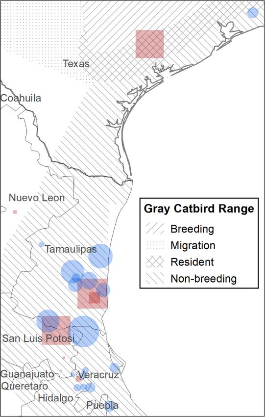
and Hidalgo. Gray Catbirds breeding in British Columbia Overwintering location estimates from birds with geolo-
traveled an average of 4048 ± 193 km to overwintering cators were less precise than GPS tags but also encom-
locations, and Gray Catbirds breeding in Montana passed San Luis Potosi, Tamaulipas, and Veracruz
traveled 3604 ± 76 km to overwintering locations. (Fig. 5). One exception is a Gray Catbird with aMancuso et al. Movement Ecology (2021) 9:10 Page 7 of 16 Fig. 1 Gray Catbird (Dumetella carolinensis) fall migration route. Southward migration path from GPS tags retrieved from Gray Catbirds breeding in the South Okanagan Valley, British Columbia, Canada, and in the Bitterroot River Valley, Montana, USA. Gray tracks are from GPS tags retrieved from catbirds in the Bitterroot River Valley (n = 12) and black tracks are from GPS tags retrieved from catbirds in the South Okanagan Valley (n = 6). World Terrain Base Map provided by ESRI, USGS, and NOAA within ArcMap 10.7.1. Map created in ArcMap 10.7.1 (ESRI 2019) using the GCS WGS 1984 coordinate system. The elevation map was created in ArcMap 10.7.1 using the 30 arc-second digital elevation model of North America (ESRI 2019) geolocator whose overwintering estimate was centered From GPS tags, we found that several Gray Catbirds over Oaxaca, Mexico, and the Pacific Ocean - the from Montana and British Columbia populations used longitude of this estimate is in accordance with all more than one overwintering location, with up to four other Gray Catbird overwintering estimates but the distinct locations documented (Table 2). Each subse- latitude appears suspect (Fig. 5). quent overwintering location was farther south than the Fig. 2 Comparing north vs. south migration routes for Gray Catbirds (Dumetella carolinensis). A comparison of southward (black) and northward migration (gray) GPS tracks from 5 different Gray Catbirds marked in their breeding site in the Bitterroot River Valley, Montana, USA. All birds were heading north by May 10, except for catbird with GPS 41820, who headed north by May 3. Map created in ArcMap 10.7.1 using the GCS WGS 1984 coordinate system (ESRI 2019)
Mancuso et al. Movement Ecology          (2021) 9:10                                                                                        Page 8 of 16

 Fig. 3 Migration stopover sites identified for Gray Catbirds (Dumetella carolinensis). Stopover sites identified using GPS tags. Crosses represent
 birds tagged in the South Okanagan Valley, British Columbia, Canada, and exes represent birds tagged in the Bitterroot River Valley, Montana,
 USA. Stars represent study site locations. All sites are from fall migration, except for the asterisk in Texas, which was a spring stopover site for a
 Gray Catbird that bred in the Bitterroot River Valley. Points are scaled relative to the amount of time spent at a site and range between 1 and 16
 days. Gray Catbird range map provided by IUCN (2016). Map created in ArcMap 10.7.1 using the GCS WGS 1984 coordinate system (ESRI 2019)

previous one, except one Gray Catbird who moved slightly                      above sea level (satellite imagery of overwintering loca-
farther north for his second overwintering location, then                     tions can be found in additional file 2).
south for subsequent locations. Distance between over-
wintering locations ranged from 5 to 353 km. The length                       Multiple years of tracking
of stay at any one overwintering location ranged from 17                      Some birds tracked over multiple years in Montana showed
to 169 days. During winter, Gray Catbirds occupied nat-                       fidelity to overwintering locations (Fig. 6). One female Gray
ural areas with dense vegetative cover, often in association                  Catbird had two similar overwintering locations based on
with edges or riparian habitats, at elevations of 9–678 m                     one GPS tag and one geolocator. This individual also had
Mancuso et al. Movement Ecology           (2021) 9:10                                                                                        Page 9 of 16

 Fig. 4 Gray Catbird (Dumetella carolinensis) overwintering sites. Overwintering points were determined from GPS tags retrieved from Gray Catbirds
 breeding in the South Okanagan Valley, British Columbia, Canada (red squares), and the Bitterroot River Valley, Montana, USA (blue circles). The size of
 the symbol represents how long the bird stayed at the site, ranging from 4 to 169 days. Most birds had more than one overwintering site. Gray
 Catbird range map provided by IUCN (2016). Map created in ArcMap 10.7.1 (ESRI 2019) using the GCS WGS 1984 coordinate system

the potentially unreliable geolocator where latitude estimates                 Mexico and one GPS tag showing Texas. Another male Gray
appeared unlikely. One male Gray Catbird had likely differ-                    Catbird showed strong overwintering fidelity over two years
ent overwintering estimates, with one geolocator showing                       based on data from two GPS tags.
Mancuso et al. Movement Ecology             (2021) 9:10                                                                                          Page 10 of 16

Table 2 Summary of Gray Catbird (Dumetella carolinensis) overwintering locations identified using GPS tags
            Winter Location 1                 Winter Location 2                      Winter Location 3                      Winter Location 4
Tag ID      Dates             State Days Dates                 State Days KM Dates                    State Days KM Dates                     State Days KM
British Columbia
  42000     Oct 12-Nov 1      NLE     20
  42005     Oct 12-Mar 9      TX      158
  48964     Oct 16-Mar 27 SLP         162     Mar 31-Apr 10 SLP        10      109
  48961     Oct 14-Apr 2      TAM     169
  48965     Oct 22-Oct 26 TAM         4       Dec 1-Feb 1      TAM     62      32    Mar 1-Mar 17     SLP     16      178 Mar 19-Apr 20 HID           32     67
  48963     Oct 16            TAM
Bitterroot River Valley
  251       Dec 7-Jan 7       TAM     30
  262       Dec 7-Feb 7       TX      62
  245       Jan 7             TAM
  40958     Oct 18-Jan 5      TAM     79      Feb 4            TAM             19    Mar 1            HID             278
  48126+ Nov 1-Nov 21         TAM     20      Dec 1-Feb 19     TAM     80      5     Mar 15-Apr 26 HID        42      275
  48120     Oct 14-Nov 11 TAM         28      Dec 1-Feb 19     TAM     81      114 Mar 8-Apr 19       VER     41      234 Apr 26-May 3        VER     7      8
  48121     Oct 29-Dec 21 VER         53      Dec 31           VER             6
  48123     Oct 14-Mar 1      TAM     138     Mar 15-Apr 26 HID        42      353
  48124     Oct 19-Mar 1      TAM     133     Mar 8-May 3      VER     56      313
  48131     Oct 14-Jan 20     TAM     98      Feb 19-Mar 8     SLP     17      168 Mar 22-Apr 26 VER          35      79
  48133     Oct 14-Feb 19 TAM         128     Mar 29-May 3     PUE     63      275
  48134     Oct 14-Mar 29 VER         176     Apr 5-May 3      HID     28      119
+This bird moved around in Tamaulipas between Oct 19 and Nov 1
Details of overwintering sites obtained from GPS tags placed on Gray Catbirds in the South Okanagan Valley, British Columbia, Canada, and the Bitterroot River
Valley, Montana, USA. Abbreviations include minimum length of stay (Days), the distance between current and previous overwintering site (KM). States are
abbreviated as Nuevo Leon (NLE), San Luis Potosi (SLP), Tamaulipas (TAM), Veracruz (VER), Hidalgo (HID), Puebla (PUE), and Texas (TX)

Migratory connectivity                                                                The top model for apparent annual survivorship of Brit-
We observed weak migratory connectivity for British                                 ish Columba Gray Catbirds included sex and had a weight
Columbia and Montana catbird populations; there was                                 of 98% and no other model had an ΔAICc value of < 2.
no significant correlation between the distances of birds                           Therefore, parameter estimates for this model alone are
in the breeding grounds and the distances of birds in the                           reported. The top model for apparent annual survivorship
overwintering grounds (rM = 0.013, P-value = 0.41). Add-                            in British Columbia included sex as a covariate for both
itionally, the average pairwise distances in the overwin-                           survivorship and detection probability (Table 1). Males
tering grounds (British Columbia: 347.2 ± 68.3 km, n =                              had greater detection probability (p = 0.72 ± 0.07) than fe-
15, Montana: 255.8 ± 34.7 km, n = 66) were greater than                             males (p = 0.25 ± 0.07) and birds of unknown sex (p =
the average pairwise distances in the breeding grounds                              0.35) but males and females had similar survivorship (ϕ =
(British Columbia: 0.74 ± 0.11 km, n = 15, Montana:                                 0.64 ± 0.05 and 0.61 ± 0.06, respectively, Table 4).
0.02 ± 0.002 km, n = 66), highlighting the degree of
spread between different phases of the annual cycle.                                Discussion
                                                                                    This study represents the first published information on
Apparent annual survivorship                                                        migration, overwintering locations, and survival rates of
The top model for apparent annual survivorship of                                   western populations of Gray Catbirds. As such, it con-
Montana Gray Catbirds included sex and site and had a                               tributes to our collective knowledge of the species and
weight of 93% and no other model had an ΔAICc value                                 provides baseline information against which to monitor
of < 2, suggesting that this model had the greatest sup-                            future population change.
port (Table 3). Therefore, parameter estimates for this                               Our findings support past suspicions that western cat-
model alone are reported. The apparent annual survivor-                             birds follow the Central Flyway, despite breeding loca-
ship was greater for males (ϕ = 0.43 ± 0.04) than females                           tions within the Pacific Flyway. The Rocky Mountains
(ϕ = 0.34 ± 0.05, Table 4).                                                         did not appear to be a barrier during fall and spring
Mancuso et al. Movement Ecology (2021) 9:10 Page 11 of 16 Fig. 5 Overwintering locations of Gray Catbirds (Dumetella carolinensis) breeding in the Bitterroot River Valley, Montana, USA. Each polygon represents the 50% Kernel Density Estimates from locations obtained from archival light-level geolocators between November 15 – March 1 for 1 year from 2014 to 2018. Gray Catbird range map provided by IUCN (2016). Map created in ArcMap 10.7.1 (ESRI 2019) using the GCS WGS 1984 coordinate system migration. GPS data from British Columbia catbirds fur- Catbirds likely originated in eastern North America and ther highlight that low-elevation corridors are likely used then slowly expanded their range northward and then to cross the mountainous landscape. westward as the continental glaciers receded [22]. The The migration route for western Gray Catbirds may absence of this species in most of the Pacific Northwest, reflect the evolution of migration in these populations such as coastal Washington, Oregon, and California, is during historical range expansion, similar to Veeries in consistent with this hypothesis. The relicts of historical British Columbia [22]. As is postulated for Veeries, Gray range expansions are recapitulated in migration and can Fig. 6 Repeat tracking of 3 separate Gray Catbirds (Dumetella carolinensis) in different years. Tracking devices were deployed in the Bitterroot River Valley, Montana, USA. The year that the track was recorded is shown. Map created in ArcMap 10.7.1 (ESRI 2019) using the GCS WGS 1984 coordinate system. Geolocator abbreviated as Geo
Mancuso et al. Movement Ecology              (2021) 9:10                                                                      Page 12 of 16

Table 3 Gray Catbird (Dumetella carolinesis) apparent annual                  their range [40, 61]. Riparian habitats identified at our
survivorship model comparison                                                 stopover locations suggest these cover types may be of
Model                 Parameters     AICc     ΔAIC     Weight     Deviance    particular importance during migration by providing
Montana (n = 741)                                                             both food and water, as has been documented for other
  ϕ (sex) p (site)    5              496.4    0.00     0.93       159.9       bird species [4, 62, 63]. Indeed, fall stopover sites appear
                                                                              concentrated after migrating along the edge of the semi-
  ϕ (sex) p (.)       4              503.0    6.56     0.04       130.5
                                                                              arid great plains and reaching the temperate forest eco-
  ϕ (site) p (sex)    5              503.7    7.27     0.02       167.2
                                                                              region, replete with wetlands, forests, and a temperate
  ϕ (sex) p (sex)     6              506.8    10.36    0.01       130.2       climate [64]. Therefore, catbirds taking the easterly route
  ϕ (.) p (sex)       4              511.3    14.91    0.00       138.9       may have experienced an evolutionary advantage by
  ϕ (TSM) p (sex)     5              513.3    16.94    0.00       138.9       spending more time in higher quality stopover habitat
  ϕ (TSM) p (.)       3              552.4    56.00    0.00       65.2        even as their range expanded westward.
                                                                                 In addition to confirming that catbirds use riparian
  ϕ (site) p (.)      3              596.4    100.00   0.00       124.3
                                                                              and edge habitats for stopovers, we also found stopover
  ϕ (.) p (site)      3              596.5    100.14   0.00       124.4
                                                                              locations dispersed on the landscape and not used re-
  ϕ (site) p (site)   4              598.2    101.76   0.00       124.0       peatedly or by the same birds, though we acknowledge
  ϕ (TSM) p (site)    4              598.6    102.17   0.00       124.4       we have a relatively small sample size and this topic
  ϕ (.) p (.)         2              600.7    104.20   0.00       115.4       merits further study. Dispersed and abundant stopover
British Columbia (n = 537)                                                    sites pose a challenge for conservation as the persistence
                                                                              of many small riparian areas along the migration route
  ϕ (sex) p (sex)     6              709.2    0.00     0.98       119.2
                                                                              may be necessary to support current Gray Catbird popu-
  ϕ (sex) p (.)       4              718.1    8.91     0.01       132.1
                                                                              lations. Alternatively, perhaps the loss of any one patch
  ϕ (sex) p (site)    5              719.4    10.16    0.01       164.3       of habitat is less consequential as long as a certain
  ϕ (site) p (sex)    5              724.0    14.82    0.00       169.0       threshold of suitable habitat is maintained at the land-
  ϕ (.) p (sex)       4              724.2    15.00    0.00       138.2       scape scale. We suggest additional study into important
  ϕ (TSM) p (sex)     5              726.1    16.91    0.00       138.1       features of stopover locations and to what extent cat-
                                                                              birds are plastic in their use of such sites. Conserving a
  ϕ (TSM) p (.)       3              813.4    104.24   0.00       51.1
                                                                              network of riparian habitats across the landscape is a
  ϕ (TSM) p (site)    4              815.4    106.22   0.00       76.4
                                                                              valuable conservation approach for not just Gray Cat-
  ϕ (.) p (.)         2              836.7    127.48   0.00       76.4        birds, but other wildlife, as it allows for landscape-level
  ϕ (site) p (.)      3              838.5    129.34   0.00       101.6       connectivity and the retention of movement corridors.
  ϕ (.) p (site)      3              838.6    129.45   0.00       101.7          Birds from both of our study populations overwintered
  ϕ (site) p (site)   4              839.7    130.48   0.00       100.7       along the Gulf Coast of Texas south into northeastern
Models for the apparent annual survivorship of Gray Catbirds in the South
                                                                              Mexico, with the highest concentration in the Tamau-
Okanagan Valley, British Columbia, Canada, and the Bitterroot River Valley,   lipas region. These sites do not overlap with known
Montana, USA. Cormack-Jolly-Seber models were used, which include annual      overwintering locations of Midwestern and mid-Atlantic
survivorship (ϕ) and detection probability (p). TSM is a time-since-marking
approach whereby the first encounter is separated from separate encounters    catbirds [13] and thus represent a major advance in our
to factor in young and transient individuals. Intercept only models are       understanding of the precise geographic linkages be-
designated by (.)
                                                                              tween breeding and overwintering catbird populations.
                                                                              We also saw some evidence of overwintering site fidelity,
be observed in other species whose breeding and over-                         though potentially erroneous geolocator data limits our
wintering grounds are continents apart, such as North-                        ability to confirm this behaviour across many individ-
ern Wheatear (Oenanthe oenanthe [56]), Bar-tailed                             uals. In any case, repeated tracking of individual song-
Godwit (Limosa lapponica [57]), and Blackpoll Warbler                         birds over multiple years is rare and, even if limited by
(Setophaga striata [58]). In British Columbia, ancestral                      sample size and technology, represents a major accom-
routes similar to what we have found in the western                           plishment of our study.
Gray Catbird have also been observed in Swainson’s                               Our study is the first to document Gray Catbird’s use
Thrushes [20, 59], but our study is the first to document                     of multiple overwintering locations; we found individuals
this phenomenon in the Mimidae family.                                        used multiple overwintering locations and moved farther
  Ancestral relicts of range expansion may also work in                       south as the winter progressed into spring. The use of
conjunction with ecological limitations to explain why                        more than one overwintering location has been observed
the migratory routes we documented are indirect and                           in a few other neotropical migrants (e.g. Prothonotary
farther east than we expected [60]. Gray Catbirds oc-                         Warblers (Protonotaria citrea), Veeries, and Swainson’s
cupy riparian habitat and shrubby edges throughout                            Thrushes [22, 65–67]). Future tracking studies on
Mancuso et al. Movement Ecology (2021) 9:10 Page 13 of 16
Table 4 Gray Catbird (Dumetella carolinensis) apparent annual survivorship model parameter estimates
Model Parameter Group Estimate Standard Error
Montana
ϕ (sex) p (site) ϕ Female 0.34 0.05
ϕ (sex) p (site) ϕ Male 0.43 0.04
ϕ (sex) p (site) ϕ Unknown 0.06 0.01
ϕ (sex) p (site) p MPG Ranch 0.77 0.07
ϕ (sex) p (site) p Other 0.34 0.10
British Columbia
ϕ (sex) p (sex) ϕ Female 0.61 0.06
ϕ (sex) p (sex) ϕ Male 0.64 0.05
ϕ (sex) p (sex) ϕ Unknown 0.20 0.20
ϕ (sex) p (sex) p Female 0.25 0.07
ϕ (sex) p (sex) p Male 0.72 0.07
ϕ (sex) p (sex) p Unknown 0.35 0.13
Parameter estimates for the top apparent annual survivorship models for Gray Catbirds in British Columbia and Montana. Cormack-Jolly-Seber models were used,
which include annual survivorship (ϕ) and detection probability (p)
additional species would help us understand if this behav- British Columbia Gray Catbirds overwintering in similar
iour is rare or common amongst neotropical migrants. The areas across northeastern Mexico. Birds that bred close
mechanisms driving overwinter movement warrants further to one another dispersed up to 1000 km apart during the
research; plausible explanations may be that birds follow a overwintering period. Weak migratory connectivity may
shift in seasonal food resources or avoid weather events. A be advantageous for the persistence of western catbird
better understanding of overwintering habitat use and how populations because individuals are dispersed across a
it may vary by age and sex is a priority for future Gray Cat- large geographic region during the overwintering period
bird research [40]. The ability of individuals to exhibit some are unlikely to be affected by local threats.
plasticity in overwintering locations, suggests a life-history One challenge in comparing migratory connectivity
strategy adapted to landscape change. From a conservation between studies is the scale in which it is examined. If
perspective, the potential plasticity of overwintering site use we consider both breeding sites from British Columbia
may be an adaptive strategy that will bode well for the fu- and Montana as one population, and the span of Texas
ture of catbird populations to persist as habitats shift due to to Veracruz as one overwintering population, it would
anthropogenic or natural causes. be perceived as strong migratory connectivity. Ryder
That Gray Catbirds use multiple overwintering loca- et al. [13] reported strong migratory connectivity for
tions and vary in their degree of overwintering location eastern and central populations of Gray Catbirds. Re-
fidelity question important assumptions of overwintering gardless, the results of our study and previous studies on
monitoring programs, such as Monitoreo de Sobrevi- migration patterns of Gray Catbirds result in a compre-
viencia Invernal (MoSI), which uses standardized mist- hensive picture of population connectivity across their
netting efforts during the overwintering period to assess range. Gray Catbirds breeding in the west overwinter in
overwintering survivorship [68]. The MoSI protocol in- Texas and northeastern Mexico [this study and 94]. Cat-
volves 5 monthly overwinter mist-netting pulses from birds breeding in the mid-west overwinter in Central
November to the end of March where each pulse occurs America [13], Catbirds breeding near the Great Lakes
over 2–3 days [69]. The Gray Catbird was one target overwinter in Guatemala [70] and Catbirds breeding in
species for the MoSI program but their overwintering the Atlantic overwinter in Cuba and the Caribbean
survivorship estimates will likely be underestimated Islands [13].
given their overwinter movements [69]. A better under-
standing of songbird overwintering movement and site Apparent annual survivorship
fidelity in other species is crucial to assessing the accur- Establishing demographic rates for species, such as ap-
acy of vital rate metrics derived from MoSI data. parent annual survivorship, are important for identifying
populations at risk of decline and informing conserva-
Migratory connectivity tion efforts [11, 71]. The estimates for Gray Catbirds in
We found weak migratory connectivity for the two Gray British Columbia (0.61 ± 0.06 female, 0.64 ± 0.05 males)
Catbird populations we examined, with Montana and exceed reported adult average survivorship values in theMancuso et al. Movement Ecology (2021) 9:10 Page 14 of 16
Northern Rockies bird conservation region (which spans From a conservation perspective, the detail we now
both study areas) of 0.54 ± 0.02 between 1992 and 2006 have on the full annual cycle of Gray Catbirds may help
[72]. For comparison, apparent annual adult survivorship in ensuring the species remains a common species on
for other common songbirds in the Northern Rockies the landscape well into the future. Preserving key areas
bird conservation region ranges between 0.50–0.59 [72]. of suitable habitat in the central and southern portions
Why the apparent annual survivorship estimates for of Tamaulipas would benefit both Montana and British
Montana Gray Catbirds (0.34 ± 0.05 females, 0.41 ± 0.04 Columbia Gray Catbirds because our study identified
males) are lower is unclear. However, when averaged Tamaulipas as a key overwintering area. Additionally,
across both sites, survivorship values match those of the with the predicted effects of climate change impacting
general Northern Rockies conservation region, so per- the persistance and quality of riparian habitats, pro-
haps the range of values we are documenting at local actively protecting and monitoring riparian areas along
sites are in line with regional trends. Because birds from their migration route and stopover areas may allow us to
both study areas traveled along similar routes and over- detect changes early [76, 77]. Moreover, should a popu-
wintered in similar locations, differences are likely attrib- lation decline occur in the future, the baseline informa-
uted to breeding locations. Breeding site fidelity in tion on the survivorship and migratory connectivity of
catbirds is linked with reproductive success, where birds these populations we describe in detail will be valuable
that successfully reproduce are more likely to return to for conservation efforts [78].
the same territory, therefore probing deeper into nest
success in Montana might provide more insight into ap- Abbreviations
AIC: Akaike’s Information Criteria; GPS: Global Positioning System;
parent annual survivorship trends [73]. Additionally, the MoSI: Monitoreo de Sobreviviencia Invernal; rM: Mantel’s correlation;
degree of urbanization between the two sites may be USA: United States of America
relevant, as eastern catbirds exhibit lower survival in
rural than urban areas (suspected due to food availabil- Supplementary Information
ity), and our Montana site was more rural than our Brit- The online version contains supplementary material available at https://doi.
org/10.1186/s40462-021-00249-7.
ish Columbia site [74]. Both study areas had resighting
efforts, which when combined with recapture methods,
Additional file 1. Low-quality geolocator results. Additional file 1 shows
improves apparent annual survivorship estimates [75]. an example of low-quality archival light-level geolocator data and the as-
However, overall resighting effort in Montana was sociated geographic assignment locations.
slightly lower than in British Columbia, and therefore, Additional file 2 Aerial imagery of stopover and overwintering sites.
could have skewed the results. As technology advances, Shows satellite imagery of stopover and overwintering site locations as
determined from GPS tags attached to Gray Catbirds (Dumetella
we are hopeful that one day we will be better able to carolinensis).
understand whether birds that do not return to the site
in subsequent years are dispersing to new areas, remain Acknowledgements
undetected, or are dying. We thank all the skilled field technicians and volunteers who deployed and
retrieved tracking devices as well as resighting and recapturing colour-
banded catbirds, including T. Forrester, A. Huang, K. Owen, M. Bieber, M.
Aubertin-Young, S. Hudson, K. Hick, A.M. Bezener, H. Hall, A. Gonzalez, S. Eng-
Conclusions lish, S. Fuller, M. Ruggles, A. Spidal, C. Taft, L. Fried, and A. Meyer. T. Rodriguez
Our study represents the first description of full annual helped prepare data files for M. Blake who modelled the coding in RMark for
cycle movements of western populations of Gray Cat- analysis of the survivorship of Montana Catbirds. M. Blake and L. Fried also
substantially increased our sample size during the 2018 field effort. We thank
birds, revealing that catbirds breeding in two disparate the En’owkin Centre and the Penticton Indian Band for their collaborative ef-
populations followed similar migratory routes eastward forts with this research. J. Pither, J. Alexander, and A. Ford suggested im-
across the Rocky Mountain Range then southward to- provements to a draft of this manuscript. We thank K. Hobson and S. Van
Wilgenburg for initiating the study of Gray Catbirds in British Columbia and
wards overwintering locations in northeastern Mexico for technical help with fitting geolocators.
and Texas, following a putative ancestral route. During
the non-breeding season, individuals from both breeding Authors’ contributions
CAB, MAF, KEH, and KRS conceived the project idea and contributed
populations spread out across overlapping geographic substantial materials, resources, and funding. Field data were collected by
areas, a case of weak migratory connectivity. Unexpect- MAF, KAM, and MBL. KAM performed data analyses, created all figures and
edly, Gray Catbirds used multiple overwintering loca- tables, and wrote the manuscript with guidance from KEH, CAB, MAF, and
KRS. All authors read and approved the final manuscript.
tions which suggests some plasticity in movement that
may help catbirds remain adaptable if landscapes Funding
change. Like many previous catbird studies, our research Funding was provided by Environment and Climate Change Canada, the
found that western catbird populations use riparian and University of British Columbia Okanagan, Natural Sciences and Engineering
Research Council of Canada for the study design, data collection in Canada,
shrubby plant communities for breeding, stopover sites, analysis, interpretation, and writing of the manuscript. Funding was provided
and overwintering sites. by Montana State University, and MPG Ranch for the study design, dataMancuso et al. Movement Ecology (2021) 9:10 Page 15 of 16
collection in the USA, survivorship analysis for catbirds in the USA, and 16. Vermeer K. Comparison of white pelican recoveries from colonies east and
editorial advice. west of the Canadian rocky mountains. Murrelet. 1977;58:79–82.
17. Toews DPL, Heavyside J, Irwin DE. Linking the wintering and breeding
Availability of data and materials grounds of warblers along the Pacific flyway. Ecol Evol. 2017;7:6649–58.
The datasets supporting the conclusions of this article will be available in the 18. Knight SM, Bradley DW, Clark RG, Gow EA, Bélisle M, Berzins LL, et al.
Open Science Framework repository. Constructing and evaluating a continent-wide migratory songbird network
across the annual cycle. Ecol Monogr. 2018;88:445–60.
19. Lisovski S, Németh Z, Wingfield JC, Krause JS, Hobson KA, Seavy NE, et al.
Ethics approval and consent to participate Migration pattern of Gambel’s white-crowned sparrow along the Pacific flyway.
All research on birds was approved by the University of British Columbia J Ornithol [internet]. Springer Berlin Heidelberg; 2019;160:1097–107. Available
Okanagan Animal Care Committee (application number A16–0079) and the from: http://link.springer.com/https://doi.org/10.1007/s10336-019-01685-4
University of Montana Institutional Animal Care and Use Committee (022–
20. Delmore KE, Fox JW, Irwin DE. Dramatic intraspecific differences in
17). Federal bird banding permits (10761 L,10761Q, 10761R, 23206) and
migratory routes, stopover sites and wintering areas, revealed using light-
Montana Fish, Wildlife, and Parks permits were acquired for bird banding
level geolocators. Proc R Soc B Biol Sci. 2012;279:4582–9.
activities in Montana.
21. Hobson KA, Kardynal KJ, Van Wilgenburg SL, Albrecht G, Salvadori A,
Cadman MD, et al. A Continent-Wide Migratory Divide in North American
Consent for publication Breeding Barn Swallows (Hirundo rustica). Brigham RM, editor. PLoS One
Not applicable. [Internet]. 2015;10:e0129340. Available from: https://dx.plos.org/https://doi.
org/10.1371/journal.pone.0129340
Competing interests 22. Kardynal KJ, Hobson KA. The pull of the central flyway? Veeries breeding in
The authors declare that they have no competing interests. western Canada migrate using an ancestral eastern route. J F Ornithol
[Internet]. 2017;88:262–273. Available from: http://doi.wiley.com/https://doi.
Author details org/10.1111/jofo.12207
1 23. Phillips AR, Marshall JT Jr, Monson GB. The birds of Arizona. Tuscon, Arizona:
Department of Biology, University of British Columbia Okanagan, Kelowna,
British Columbia, Canada. 2Division of Biological Sciences, University of University of Arizona Press; 1964.
Montana, Missoula, MT, USA. 3Science and Technology Branch, Environment 24. Garcia-Perez B, Hobson KA. A multi-isotope (δ2H, δ13C, δ15N) approach to
and Climate Change Canada, Delta, British Columbia, Canada. 4Oliver, establishing migratory connectivity of barn swallow (Hirundo rustica).
Canada. 5MPG Ranch, Florence, MT, USA. Ecosphere. 2014;5:1–12.
25. Pyle P. Identification guide to north American birds - part I. Bolinas,
Received: 16 November 2020 Accepted: 24 February 2021 California: Slate Creek Press; 1997.
26. British Antarctic Survey and Biotrack. Light-level geolocators: M-Series
geolocator models [Internet]. 2012. Available from: http://www.birdtracker.
References co.uk/geolocators_2.html. Accessed 7 Apr 2020.
1. Rosenberg KV, Dokter AM, Blancher PJ, Sauer JR, Smith AC, Smith PA, et al. 27. Lotek Wireless Inc. PinPoint GPS store-on-board loggers [Internet]. 2020. Available
Decline of the North American avifauna. Science (80- ). 2019;366:120–4. from: https://www.lotek.com/products/pinpoint-gps. Accessed 7 Apr2020.
2. Sauer JR, Pardieck KL, Ziolkowski DJ, Smith AC, Hudson MR, Rodriguez V, 28. Rappole JH, Tipton AR. New harness design for attachment of radio
et al. The first 50 years of the north American breeding bird survey. Condor. transmitters to small passerines. J F Ornithol. 1991;62:335–7.
2017;119:576–93. 29. Bridge ES, Kelly JF, Contina A, Gabrielson RM, MacCurdy RB, Winkler DW.
3. Lovejoy TE. Foreward. In: Elphick J, editor. Atlas Bird Migr. Richmond Hill, Advances in tracking small migratory birds: a technical review of light-level
Ontario: FireFly Books Ltd.; 2007. p. 4. geolocation. J F Ornithol [Internet] 2013;84:121–137. Available from: http://
4. Carlisle JD, Skagen SK, Kus BE, van Riper C, Paxton KL, Kelly JF. Landbird doi.wiley.com/https://doi.org/10.1111/jofo.12011
migration in the American west: recent progress and future research 30. Helms JA, Godfrey AP, Ames T, Bridge ES. Predator foraging altitudes reveal
directions. Condor. 2009;111:211–25. the structure of aerial insect communities. Sci Rep Nature Publishing Group.
5. Marra PP, Cohen EB, Loss SR, Rutter JE, Tonra CM. A call for full annual cycle 2016;6:1–10.
research in animal ecology. Biol Lett. 2015;11:20150552. 31. Care Canadian Council on Animal. Species-specifc recommendation on:
6. Marra PP, Holberton RL. Corticosterone levels as indicators of habitat quality: Birds. 2008.
effects of habitat segregation in a migratory bird during the non-breeding 32. Geen GR, Robinson RA, Baillie SR. Effects of tracking devices on individual
season. Oecologia. 1998;116:284–92. birds – a review of the evidence. J Avian Biol. 2019;50:1–13.
7. Webster MS, Peter P, Haig SM, Bensch S, Holmes RT, Webster MS, et al. Links 33. Lotek Wireless Inc. PinPoint Host User Manual, rev. 10. PinPoint Host
between worlds: unraveling migratory connectivity. Trends Ecol Evol. 2002; Application for PinPoint GPS Tags. 2018.
17:76–83. 34. Biotrack Limited. M-series geolocator user manual. Wareham, Dorset, United
8. Faaborg J, Holmes RT, Anders AD, Bildstein KL, Dugger KM, Gauthreaux SA, Kingdom: Biotrack; 2013.
et al. Conserving migratory land birds in the New World: do we know 35. R Core Team. R: A language and environment for statistical computing
enough? Ecol Appl. 2010;20:398–418. [Internet]. R Found. Stat. Comput. Vienna, Austria. 2018. Available from:
9. Boulet M, Norris RD. Introduction: the past and present of migratory https://www.r-project.org/. Acccessed 8 Nov 2020.
connectivity. Ornithol Monogr. 2006;61:1–13. 36. Lisovski S, Bauer S, Briedis M, Davidson SC, Dhanjal-Adams KL, Hallworth MT,
10. Finch T, Butler SJ, Franco AMA, Cresswell W. Low migratory connectivity is et al. Light-level geolocator analyses: a user’s guide. J Anim Ecol. 2020;89:
common in long-distance migrant birds. J Anim Ecol. 2017;86:662–73. 221–36.
11. DeSante DF, Nott MP, Kaschube DR. Monitoring, modeling And 37. Lisovski S, Hahn S. Geo light - processing and analysing light-based
management: why base avian monitoring on vital rates and how should it geolocator data in R. Methods Ecol Evol. 2012;3:1055–9.
be done? USDA Forest Service Gen. Tech. Rep. PSW-GTR-19; 2005. 38. Lisovski SS, Wotherspoon SJ, Sumner MD. TwGeos: Basic data processing for
12. Saracco JF, Desante DF, Kaschube DR. Assessing landbird monitoring light-level geolocation archival tags. R package version 0.1.2. 2016.
programs and demographic causes of population trends. J Wildl Manag. 39. Calenge C. The package “adehabitat” for the R software: a tool for the
2008;72:1665–73. analysis of space and habitat use by animals. Ecol Model. 2006;197:516–9.
13. Ryder TB, Fox JW, Marra PP. Estimating migratory connectivity of gray 40. Smith RJ, Hatch MI, Cimprich DA, Moore FR. Gray Catbird (Dumetella
catbirds (Dumetella carolinensis) using geolocator and mark–recapture data. carolinensis), version 1.0. In: Poole AF, editor. Birds of the World [Internet].
Auk. 2011;128:448–53. Ithaca, New York: Cornell Lab of Ornithology; 2020. Available from: https://
14. IUCN. Dumetella carolinensis. Data downloaded on December 16, 2016. doi.org/https://doi.org/10.2173/bow.grycat.01. .
[Internet]. 2016. Available from: www.iucnredlist.org. Accessed 16 Dec 2016. 41. Hill RD, Braun MJ. Geolocation by light level. The next step: latitude. In:
15. Woodrey MS, Moore FR. Age-related differences in the stopover of fall Sibert JR, Nielsen JL, editors. Electron Tagging Track Mar Fish. Dordrecht,
landbird migrants on the coast of Alabama. Auk. 1997;114:695–707. Netherlands: Springer; 2001. p. 315–30.You can also read