A Teachers Guide and Lesson Plans for:
An Adventure in Time: the Gault Project
←
→
Page content transcription
If your browser does not render page correctly, please read the page content below
A Teachers Guide and Lesson Plans for: An Adventure in Time: the Gault Project

Gault School of Archaeological Research

Teacher’s Guide for GSAR DVD
   1. Introduction –
              A hypothesis about the peopling of the Americas began when, in 1590, Fr. Jose
      de Acosta first proposed a walking migration from Asia to the Americas. Since that time,
      scientists have honed this hypothesis with little room for other ideas or discussion. In
      1929 distinctive stone projectile points were found along with extinct Pleistocene
      animals at Blackwater Draw near Clovis, New Mexico; this discovery led to the definition
      of the “Clovis culture,” currently known as the earliest tool technology and
      representative of the first peoples in the Americas.

              The leading hypothesis had nearly become theory, one in which people migrated
       across Beringia from Asia about 13,500 years ago following the mammoth herds that
       they hunted. Upon arrival in what is now Alaska, they were confronted with an ice-free
       corridor more than 2,000 miles long. These people walked through this passage, which
       ran between the Cordilleran and Laurentian glaciers, and then rapidly spread out
       throughout the Americas.

               As plausible as this hypothesis seemed, there have always been problems with
       the idea. For instance, there has never been any geological or archaeological proof for
       the existence of an ice-free corridor. Research has provided data in the form of scatter
       plots of all known Clovis point finds across the Americas and shows the greatest
       concentrations in the southeast and not the northwest—a stark contrast to what the
       model would predict. Another factor to consider is that Clovis stone tool technology is
       defined as a broad, complex, and highly sophisticated technology, which would have
       made it highly unlikely to have been utilized by pioneers.

               In the 1970s archaeologists discovered a site called Monte Verde, in southern
       Chile, that was reliably dated to 14,500 years ago, or more than 1,000 years prior to the
       hypothesized land migration. Other sites such as Meadowcroft Rockshelter
       (Pennsylvania, 16-19,000 years ago), Cactus Hill (Virginia, 15-17,000 years ago), and the
       recent discovery of human coprolites (fossilized excrement) at Paisley Cave (Oregon,
       14,300 years ago) have reinforced the argument that Clovis technology does not
       represent the first peoples.

The Gault Project: An Adventure In Time

Teacher Study Guide                                                                       Page 1
Gault School of Archaeological Research
Scientists have also taken a closer look at Clovis technology and associated
remains. The culture is not one of big game hunters but of generalized foragers (like
those who came after them) who used all the resources at hand to survive. Their
technology and resource utilization suggests a complete knowledge of their
surroundings and a complex culture including numerous organic (bone, wood, leather,
basketry) components.
Based on this evidence, we are now in what is termed a “paradigm shift” in
science —the old hypothesis has been thrown out, and there are no sure frontrunners
among the numerous new hypotheses being proposed. These include migration routes
along the Pacific Coast, Atlantic, across northern North America, as well as combinations
of multiple routes.
The Gault Site has assumed a great deal of importance in this debate. First, if one
is looking at Clovis materials for clues as to earlier cultures, then it is necessary to look
at the collections from Gault, where more than half of all Clovis-excavated materials
from Canada to Venezuela, have been scientifically collected. Secondly, there are
indications, specifically stone tools predating the Clovis people, of another culture at
Gault. The evidence being gathered at Gault could mean that it will become the defining
site for this earlier culture.
2. Outline of the segments of “The Gault Project: An Adventure in Time”
(DVD Player marker 00:00) I. Introduction What is archaeology?
Archaeology is a way to understand the past and study the origins and behavior
of early humans. The Gault site, in Bell County, TX, serves as an important
window into a crucial period in North American prehistory roughly 9,000 to
14,000 years ago.
Archaeology is study of past (and present) human cultures through their
material artifacts and environmental data. Much of what is regarded and taught
as history is in fact archaeology, or the understanding of the event/peoples has
been enhanced through archaeology. Unlike the Indiana Jones image,
archaeologists are only interested in artifacts so far as they are able to fill in
parts of a larger story. Like any good detective, archaeologists try to find lots of
The Gault Project: An Adventure In Time
Teacher Study Guide Page 2Gault School of Archaeological Research
materials in context in order to reconstruct what went on at a site and then learn
what that might reveal about the people involved.
(2:10) II. Stone: the ultimate time capsule (stone tools)
Prehistoric cultures made tools out of many materials such as
wood, bone, and stone, but due to poor preservation, archaeologists often have
only stone tools to study. Stone tools in Texas are often made out of chert or
flint, a hard rock that splinters with sharp edges. The manufacture of stone tools
is a sophisticated form of sculpture and finding tools in context, buried in the
ground, allows archaeologists to reconstruct human
actions in their manufacture, providing clues about
past behavior.
Stone tools have been used
throughout the world for a very long time, and
today there are still some cultures utilizing them.
The first known stone tools (Olduwan) are up to 2.6
million years old in East Africa. Stone tools may be
made from ground stone (mortars, querns, manos,
and metates) or from chipped stone. The process of
making stone tools is called knapping, and the
people who do it are generically called flintknappers
(even if they aren’t knapping flint). Chert or flint is
among the best materials for making stone tools,
and the Edwards Plateau in Texas is one of the
largest sources of chert in North America. Edwards chert can be found 1,500
miles away from the plateau in archaeological sites.
(4:07) III. Preserving a rare treasure (heritage stewardship)
The Gault Site has been known to science since 1929, but it was
often visited by collectors and looters during the next 70 years. Through the
efforts of the landowners and archaeologists working together the site has been
preserved and will be protected by the Archaeological Conservancy, a national
non-profit dedicated to acquiring and preserving archaeological sites.
The Gault Project: An Adventure In Time
Teacher Study Guide Page 3Gault School of Archaeological Research
Archaeological laws in the United States cover artifacts and sites
found on public property and in those projects that receive public funding.
Private property owners may do as they please on their own land. There are
many ways to be a good steward of cultural resources, including documentation
of sites or finds, stabilization, and protection from looting and vandalism.
Granting archaeological easements or even outright donation of land to
nonprofits that protect these resources, such as the Archaeological Conservancy,
are other responsible ways of protecting the past.
(5:11) IV. An embarrassment of riches (Gault’s importance)
Gault is scientifically important because of the large quantities of
data discovered there, including more than 2 million artifacts. Included in this
count is a huge collection, approximately more than 50% of all excavated Clovis
artifacts, that provide a new look at this ancient culture. Gault also serves as an
educational laboratory where professionals, students, and the public can learn
about archaeology and the first peoples in Texas.
There are many possible explanations for the large quantities of
artifacts at Gault. Although unlikely, the reason could be that the combinations
of resources—water, environment, flora, fauna, and chert—were unique.
Another possibility is that Gault may be a site at which multiple hunting and
gathering groups came together periodically to share information, resources,
and genetics. There may also be other sites like Gault, but if there are,
archaeologists have not yet found them.
(6:30) V. Understanding Clovis (the Clovis culture)
The Clovis culture is defined from an artifact collection found at
Blackwater Draw near Clovis, New Mexico. Beginning in 1929, at the same time
as the first excavations at Gault, Clovis projectile points were found at the New
Mexico site with the skeletons of animals that became extinct 10,000 years ago.
The Clovis culture was later dated to around 13,500 to 13,000 years ago and was
originally thought to represent the first people in the Americas. Their tools, it
was believed, exemplified a culture of highly mobile big game hunters who
entered North America from Asia 13,500 years ago.
The Gault Project: An Adventure In Time
Teacher Study Guide Page 4Gault School of Archaeological Research
The Clovis culture may or may not represent a single people.
Think of an iPod or Coke culture where these items are shared by large numbers
of people who may share nothing else in common. Keep in mind, too, that we
are also looking at just one small part of an overall tool kit. This would be much
like defining your life and culture by looking at just your everyday tableware. This
culture (or cultures) would also have had bone, wood, leatherwork, basketry,
clothing, and other material artifacts that no longer exist.
(8:02) VI. A new perspective on an old theory (Clovis first model vs. new)
There have always been some apparent flaws in the Clovis-first
hypothesis. The Clovis culture exhibits a complex technology, sophisticated
understanding of the environment and, broad spectrum of hunting and
gathering. The large quantities of materials at Gault also suggest that these early
people stayed in one place
for quite a while. While the
old hypothesis called for a
single migration of people
from Asia, many scientists
today are looking at the
possibility of multiple
migrations using different
routes at different times.
The old
model—that people walked from Asia following mammoth herds 13,500 years
ago—is dead. Part of the reason that the theory has been debunked is because
there are now a number of documented archaeological sites in the Americas
dating to more than 14,000 years ago and older. As a result, there are a number
of new hypotheses circulating that archaeologists must test; they must also find
a type site for the culture predating Clovis on which they can all agree. Clovis was
defined from artifacts found in context in New Mexico (Blackwater Draw) in
1932, yet Lewis & Clark had found Clovis points (without context) in 1804.
(11:06) VII. What lies Beneath (preClovis cultures)
The Gault Project: An Adventure In Time
Teacher Study Guide Page 5Gault School of Archaeological Research
Most archaeologists no longer believe that Clovis represents the
first peoples, and Gault may provide evidence of this. Deep below Gault’s Clovis
strata lies evidence of an earlier occupation that current excavations are trying
to uncover and understand.
Sites such as Monte Verde (Chile, 14,500 years old) and Paisley
Cave (Oregon, 14,300 years old) indicate that people were in the Americas prior
to the Clovis culture. The questions being asked now by scientists are, who were
these people, where did they come from, and what did their material culture
look like? Was it one group or several, from only one place or more, and did they
arrive all at one time or in multiple migrations? The Gault site may provide
insight into some of these questions and help archaeologists define the next set
of challenges.
(12:19) VIII. Digging, Details, Data (the science of archaeology)
Archaeology is a painstaking, slow, and detailed science. Not only
must excavators record all of the artifacts and objects that will be removed, but
they must also document the things that that are intangible – changes in soil
color, texture, presence of rocks, etc. The
goal is to build up enough data so that future
researchers could exactly reconstruct an
excavation. Archaeologists interested in the
earliest peoples in the America pay close
attention to soil stratification, the layers of
soils, and geological changes that can provide
clues as to changes over time. Understanding
cultural change helps scientists understand
past human behavior.
Society’s picture of
archaeologists is usually either that of the
dashing treasure hunter (Indiana Jones, Lara
Croft) or the dirt digging, absent-minded
professor. Rarely are archaeologists portrayed in the place where they spend
most of their time: the laboratory. Archaeology is painstaking detective work
that today involves complex scientific instruments and processes as well as much
The Gault Project: An Adventure In Time
Teacher Study Guide Page 6Gault School of Archaeological Research
old-fashioned study. There is no one right way to conduct an archaeological
excavation or laboratory study; this is determined by the circumstances and the
scientific questions being asked.
(15:13) IX. Analyzing the tools (how we know what we know, use wear)
In order to understand cultural change, archaeologists must
carefully analyze recovered artifacts and their context, the circumstances and
surroundings of their find spot. One useful way to study stone tools is through
microscopic usewear analysis. When a tool is used on a material in a specific
way, marks and residues are left behind that can be seen under a microscope.
This microscopic detail allows archeologists to determine how the tool was used
in the past and on what.
For archaeologists, the artifact is not the Holy Grail; it is only part
of an ancient puzzle to be re-constructed. Finding a large number of artifacts in
context with other data allows scientists to piece together stories of the past
that will help explain how people lived and responded to change.
(16:43) X. It’s more than archaeology (collaborative science)
Modern science is no
longer a lone wolf effort of one
pioneering scientist. Collaboration
with a wide range of sciences helps
piece together a much more
complete and complex story
regarding early peoples.
Archaeologists utilize
the knowledge of many other
sciences such as genetics (examining
the DNA from tools or ancient
remains), physics (most
archaeological absolute dating
techniques as well as material
sourcing), microscopy (from usewear study to looking at cell structures), soil
science, geology, botany, physical anthropology, paleoclimatology, etc. This is
The Gault Project: An Adventure In Time
Teacher Study Guide Page 7Gault School of Archaeological Research
one of the reasons that for an archaeologist there is such a high ration, at least
20:1, of days in the lab versus days spent in the field.
(18:58) XI. The adventure continues (GSAR, responsibility to the public)
Archaeological clues to the peoples of the past are all around, if
we look closely enough. Modern archaeological excavations have a responsibility
not only to the scientific community but also to the general public. The Gault
School of Archaeological Research was founded to teach both archaeology and
the current understanding of archaeological data to students and the public.
The GSAR is a nonprofit dedicated to research and education
regarding the earliest peoples in the Americas. The organization is committed to
defining and refining scientific knowledge as well as the dissemination of that
information to the public.
3. A glossary of terms used in the movie (and perhaps others that will come up in
discussions or the activities):
Absolute dating – dates expressed as specific units of measurement such as days, years etc. as
opposed to relative dating
Archaeophysics – the application of physics to archaeology which includes most absolute dating.
Archaic – in the U.S generally a period of time from the disappearance of Pleistocene big game
animals and ending with sedentary agriculture. In Texas generally 9,000 -1,200 years ago.
Arrowheads – small projectile point (bone, stone, metal) used on an arrow.
Atlatl and darts – also known as spear throwers. A device for increasing thrust when throwing a dart
by extending the length of the thrower’s arm.
Beringia – present day Bering Straits, Bering and Chukchi Seas, which were above water for most of
the period 25,000 to 10,000 years ago.
Biomes – a large geographical area of distinctive plant and animals groups that are adapted to a
particular environment.
Bison antiquus – an ancestor of the modern buffalo (Bison bison) which was 15-25% larger with horns
that spread nearly 3 feet from tip to tip. Became extinct around 10,000 years ago.
The Gault Project: An Adventure In Time
Teacher Study Guide Page 8Gault School of Archaeological Research Bow & arrows – a weapon system utilizing elasticity (bow) to project a dart (arrow). Introduced to Texas around 1,200 years ago. Chert – a finely crystalline form of the mineral silica, a rock that is durable and breaks with very sharp edges. Also called flint, jasper, and chalcedony. Clovis – a complex of paleoindian cultural traits in North America dating to around 13,500 years ago as defined at the site of Blackwater Draw near Clovis, NM. Blackland Prairie – a temperate grassland ecoregion stretching from the northern Texas border to San Antonio that was shaped by wildfires and bison. Columbian Mammoth – (Mammuthus Columbi) an extinct species that was one of the largest elephants ever at 14 feet tall and 10-11 tons. Columbian mammoths roamed from the area that is now the United States and into Mesoamerica and became extinct around 10,000 years ago. Ecoregions - ecologically and geographically defined area smaller than an ecozone with distinct assemblages of natural communities and species Ecosystems – an area smaller than an ecoregion where living things are linked together Ecotone – the transition area between two differing plant and animal communities. Ecozone – the largest scale biogeographic division of the earth’s plants and animals. Edwards Plateau – the southernmost unit of the Great Plains made up primarily of well-drained limestones with poor soils covering much of 40 counties in west-central Texas. Geologist – a scientist that studies both the solid and liquid matter that make up the earth. Giant Sloth – (Megalonyx jeffersonii) a large sloth 8-10 feet long weighing up to 800 lbs that became extinct about 10,000 years ago. Glyptodont - a family of ancient ancestors of the modern armadillo that were the size of a small automobile. Horse (extinct) – horse evolved in the New World with some species crossing to Eurasia 2-3 million years ago. The species remaining in the Americas became extinct 10,000 years ago. Lampasas Cut Plains – a region often considered to be a northern extension of the Edwards Plateau consisting of numerous valleys scored into the limestone. The Gault Project: An Adventure In Time Teacher Study Guide Page 9
Gault School of Archaeological Research

Lance – though the term actually derives from the same root as “to launch,” it later came to define a
variety of thrusting weapons.

Late Prehistoric – in Texas a period defined as that from the introduction of the bow and arrow
(around 800 AD) to contact with the first European explorers.

Mastodon – (Mammut americanum) an extinct elephant species that looked much like the wooly
mammoth. Mastodons lived in woodlands and were up to 10 feet tall.

Midden – a garbage heap resulting from human activities.

Paleoecologist – a scientist who uses data from fossils to reconstruct the ecosystems of the past.

Paleoindian – a period representing the first peopling of the Americas to the advent of Archaic
foraging. Today it is known that there is not much separating the lifestyles of the cultures in these
two periods.

Paleontologist – a scientist who studies prehistoric life, especially the study of fossils.

Pleistocene – a geological period beginning 2.588 million years ago and ending 10,000 years ago
meaning “most recent” (as opposed to the current Holocene or “entirely recent” period)

Pleistocene extinction – an event or events taking place approximately 10,000 years ago in which 15
genera of large animals went extinct including mammoths, mastodons, sabre tooth tigers,
glyptodonts, giant sloths, giant beavers, horses, American lions and dire wolves.

preClovis – a culture currently defined by what it isn’t, i.e. Clovis

Projectile point - a chipped stone or bone artifact used to tip an arrow, dart, lance, or spear.

Relative dating - dates expressed in relativistic terms such as later, more recent, after the mammoth
became extinct etc.

Soil chemist – a scientist who studies the chemical characteristics of the soil. In archaeology, soil
chemistry can tell much about areas in which humans lived and worked.

Spear – a pole weapon generally hand thrown.

Striations – a series of ridges, furrows and linear marks that, in usewear analysis, can tell what a tool
was probably used for.

The Archaeological Conservancy – a national nonprofit dedicated to the acquisition and preservation
of American archaeological sites.

The Gault Project: An Adventure In Time

Teacher Study Guide                                                                                 Page 10
Gault School of Archaeological Research

Unit Level Record – the primary written record for one unit of excavation. At Gault this would detail a
1 meter area 5-10 cm deep.

usewear - a method in archaeology to identify the functions of artifact tools by closely examining
their working surfaces and edges.

   4. Topics for discussion and discussion questions. A guide to leading discussions of some of
      the topics in the film.
              What is the difference between a scientific hypothesis and theory?
              Why is a site like Gault important to scientists?
              Who owns the past?
              Why should we, as a culture, protect cultural resources?
              Why is archaeology important?
              Are stone tools sculpture and how does this affect their manufacture?
              What can we learn about the earliest peoples in the Americas from looking at
                       Clovis artifacts?
              What kind of problems were there in the “Clovis First” hypothesis?
              If scientists find a culture that pre-dates Clovis, how would that change what we
                        are learning now?
              Are Indiana Jones or Lara Croft archaeologists? Why or why not?
              What can artifacts in context reveal that lone artifacts cannot?
              How can other sciences help archaeologists?
              Is it important for archaeologists to educate the public?

   5. Resources:
       Texas Beyond History – www.texasbeyondhistory.net
       GSAR – www.gaultschool.org
       Texas Archaeological Society – www.txarch.org
       Shumla School – www.shumla.org
       Texas Historical Commission - www.thc.state.tx.us

       The Archaeology Channel – www.archaeologychannel.org

The Gault Project: An Adventure In Time

Teacher Study Guide                                                                              Page 11
Gault School of Archaeological Research
Archaeological Institute of America – www.archaeological.org
Society for American Archaeology – www.saa.org
Society for Historical Archaeology – www.sha.org
:
The Gault Project: An Adventure In Time
Teacher Study Guide Page 12Lesson Overview: Students develop an outdoor classroom to investigate and understand
the complexity of an ecotone area and make predictions as to why the Clovis people
chose to live near an ecotone.
Objectives:
*to describe characteristics of ecotones in our schoolyard
*to document characteristics of an ecotone plot area
*to understand how ecosystems are connected to each other.
*to describe why there is a greater diversity of plants and animals in an ecotone rather
than in separate ecosystems
*to define an ecotone and state its ecological significance
Texas Essential Knowledge and Skills (TEKS):
Science
(9) Science concepts. The student knows that adaptations may increase the survival of
members of a species. The student is expected to: (A) compare the adaptive
characteristics of species that improve their ability to survive and reproduce in an
ecosystem; (B) analyze and describe adaptive characteristics that result in an organism's
unique niche in an ecosystem; and (C) predict some adaptive characteristics required for
survival and reproduction by an organism in an ecosystem.
Time Frame: 2 hours
Materials: (classroom ) blue, yellow, and red colored pencils (map colors)
(outdoors)- Ecotone Scavenger Hunt - clipboard with attached “Ecotone
Scavenger Hunt” sheet, a 10-meter nylon string marked in 30cm intervals, magnifying
glass, pencils, digital camera (optional) for small groups of students
Vocabulary:
ecosystem – a community of living and non-living things that work together.
ecotone – the transition zone between two different plant ecosystems (communities)
community - a group of one or more populations of plants and animals in a common
space
adaptation - a behavioral change or body change that helps an organism surviveInput: When you look at a city map of Texas, the rural town of Florence is little more than a speck on a map. One wouldn’t imagine that this tiny community’s residents are “living on the edge.” Yet, more than 14,000 years ago as first people drifted toward the area, they began to realize that they were onto something special. They became the first permanent residences in Texas “living on the edge” of three large distinct ecosystems! Texas is a BIG state. So big, in fact, that it is divided into seven large ecosystems (communities). Each ecosystem has different landforms, animals, plants, and even weather. Now imagine the benefits one would receive from “living on the edge” of three ecosystems! This resourceful “edge” is known as an ecotone and the Clovis people came to realize that what one edge lacked in resources, the other two would supply. An ecotone is the edge where landscapes meet -- like plain with mountain, or grassland with desert. Where the two communities merge, a diverse group of animals make their home . . . animals with their own adaptations. An ecotone still carries some of the ecological features of both communities, but has its own distinct ecological structure providing more of the needs for a variety of wildlife than does a single vegetative type. Lesson Introduction: Ask students what they see when they look through a kaleidoscope. As you look through one end of the tube and turn, you will see a constantly changing set of colors and patterns. Now imagine the world’s landscapes as a kaleidoscope, color edges overlapping each other and forming new patterns and colors. Lesson: Introduce ecotone definition. Draw three overlapping circles on the board. Have students copy your drawing onto paper and color one circle blue and label Ecosystem A. Color the other circle red and label Ecosystem B. Color the third circle yellow and label Ecosystem C. The area where a circle overlaps another circle is called an Ecotone. Label each of the four overlaps, Ecotone. a. Ask the students what color is formed at each Ecotone. (A and B = purple, A and C = green, B and C = orange, and A and B and C = brown. b. Now have each student draw two specific kaleidoscope (geometric) shapes in Ecosystem A. And a completely different set of shapes in Ecosystem B. Ask the students that if the ecotone is a common area, what would they draw in the overlapping ecotone? (shapes from both ecosystems). What will have to happen as the shapes move into the ecotone? (Unique adaptations will have to be made, but look at the diversity or variety of shapes!) Repeat for Ecosystem C. What happens in the section where all three Ecoystems intersect? This is the Ecotone with the greatest diversity!
c. Give an example of a Texas ecotone‐‐ Small-scale ecotones are even more
     recognizable and can be found everywhere you turn. In Texas, the cottontail rabbit is
     a resident of a country road – grazed farmland ecotone. The dense vegetation behind
     the road is the perfect hideout during the day from predators such as coyotes, hawks
     and foxes. Yet during the twilight-early morning hours, the cottontail will forage the
     wide variety of grasses and forbs provided by the cultivated field. Adaptations may
     include a sharp sense of smell, large ears with a pivotal cup to detect faint sounds, and
     eyes that are located on the sides of its head for wide peripherally vision. A cottontail
     also requires little water since it gets most of the moisture it needs from the greens it
     eats. In the winter, its fur is sometimes more gray (rather than that sort of speckled
     brown as in the summer).

d. Edges are an exciting place to be! And so ecotones also attract humans—to places
like beaches, lakesides, wetlands, open vistas just beneath a mountain, etc. Lead a
discussion on the ecosystems that merge to form each ecotone.

Lesson:   ECOTONE SCAVENGER HUNT
Investigate an ecotone: If you look outside your classroom window you will see
abundant small-scale ecotones. Just a few are found in places such as:

1.   between parking lot and the lawn
2.   between sidewalk and the lawn
3.   between lawn and a bed of planted oak trees
4.   between the playing field and the concession stand
5.   between the run-off ditch and the grassy lot
6.   between lawn and the playground area

Move outside -

•    Small groups of students will choose of a particular ecotone and will be responsible
     for performing the surveys for their location listed on the “Ecotone Scavenger Hunt”
     sheet. Each student is responsible for recording this data for use in answering the
     analyze questions.

Move to the classroom - share results aloud.

a. Terms such as habitat, ecosystem, adaptations, diversity, help to describe an ecotone.
    Give real-life examples of each of these terms.
b. Discuss the results of the ECOTONES SCAVENGER HUNT and point out examples of
some trends. Collect and grade.
c. Make predictions as to why an ancient people may have chosen to live in an ecotone
   rather than in one particular ecosystem.
Research Questions: 1. What are some of the plants in your chosen ecosystems and ecotone? Go back and identify. 2. What are some other examples of ecotones in Texas? 3. Identify central Texas animals and plants that make their homes in ecotones. 4 Locate the Gault site on a map and name three ecosystems that encompass that area. What are examples of natural resources that may have been available to the Clovis people?
ECOTONE - SCAVENGER HUNT
                                                                           Ecosystems - In the diagram -
              Ecosystem A                 Ecosystem B
                                                                           * Identify and record the two
                              Ecotone
                                                                           ecosystems that make up
                                                                           your ecotone. (10 pts)

                                                                           *Using the scale of the string,
                                                                           measure and record the width of
                                                                           the two ecosystems. Then measure
                                                                           and record the width of the
                                                                           ecotone. (15 pts.)

 Biodiversity - What kinds of life could this ecotone support? What evidence of life can you see? (10 pts)
                (worms, snails, insects, plants, etc.)
 ___________________________________________________________________________
 ___________________________________________________________________________
 ___________________________________________________________________________

 What indirect evidence of life can you see? (eaten leaves, feces, footprints, feathers, egg shells, etc.) (10 pts)
 .___________________________________________________________________________
  ________________________________________________________________________
  ___________________________________________________________________________

 Visual appearance - How does the ecotone look? Healthy? Note things like plant cover, landscapes, any
                     man-made structures, etc. (10 pts)
   __________________________________________________________________________
   __________________________________________________________________________
   __________________________________________________________________________
 Conditions - What other condition may affect your ecotone? (15 pts)
              Examples: sunlight, shade, rain, runoff, foot traffic, etc.
  ___________________________________________________________________________
  ___________________________________________________________________________
  ___________________________________________________________________________
 Adaptations - describe any special adaptations of the plants or animals in each zone for the most species
               abundant species. (15 pts.)
_________________________________________________________________________________________
_________________________________________________________________________________________
_________________________________________________________________________________________
_________________________________________________________________________________________
 Predator/Prey - What are some predator/prey relationships that could inhabit the area? (15 pts.)
____________________________________________________________________________
____________________________________________________________________________
____________________________________________________________________________
Lesson Overview:.Students will design a 3‐D paper paleoenvironment that details the
Gault site as an ecotone by highlighting resources (living and non‐living) obtained from
three surrounding ecosystems (ecoregions).
Objectives:
*to better understand a large ecotone
*to describe why there is a greater diversity of plants and animals in an
ecotone rather than in separate ecosystems
*to identify and locate the Gault site on an Texas Ecoregions map
*to identify the three encompassing ecosystems (ecoregions)
*to list available natural resources at the Gault site for the Clovis people
Texas Essential Knowledge and Skills (TEKS):
Reading (5.8 C) read for varied purposes such as to be informed (5.9C) use multiple
reference aids to clarify meaning and usage (5.10C) represent text information in
different ways such as in a graphic organizer
Science
(5.3A) analyze, review, and critique scientific explanations, including hypotheses and
theories, as to their strengths and weaknesses using scientific evidence and information
(5.3E) connect Grade 5 science concepts with the history of science and contributions of
scientists. (5.9A-C) know that adaptations may increase the survival of members of a
species.
Geography
(5.6A-B) uses geographic tools to collect, analyze, and interpret data (5.9A‐C )The
student understands how people adapt to and modify their environment.
Social Studies (25) Social studies skills. The student applies critical‐thinking skills to
organize and use information acquired from a variety of sources including electronic
technology. The student is expected to: (C) organize and interpret information in
outlines, reports, databases, and visuals including graphs, charts, timelines, and maps
Time Frame: 1 week
Materials: small county map of Texas
“Level III & IV Ecoregions of Texas,” paper-sized map
computers with internet access
12”x18” heavy-weight, white construction paper
pencil, scissors, glue
Vocabulary:
county – a land area of local government within a state
natural resource - a material that occurs in nature that can be used for housing clothing,
heating cooling, transportation, and to meet other human wants and needs, such as
timber, fresh water, rocks, fossil fuels, etc.plateau - a land area having a relatively level surface considerably raised above adjoining land on at least one side, and often cut by deep canyons. prairie – a level tract of land, mostly treeless, with highly-fertile soil and course grasses Input: If you wonder why the Clovis people came to Gault and stayed for at least 400 years, it’s important to know where it is and what it had to offer. The Gault site is located in central Texas about 40 miles north of Austin, and sits on Buttermilk Creek near the little town of Florence, Texas, in Bell County. Latitude: 30.892N, Longitude: 97.709W. Archaeologists (the scientists who study the cultures of people long ago) know now that the Clovis people did not live in the area seasonally, going back year after year to hunt and fish or to gather food supplies for the year, but made the area their semi-permanent home. Because Gault sits in a small ecotone, staying in this area was a great idea! Their surroundings not only provided an abundance of resources, but also, overtime, provided the people with the knowledge of how to survive and live life comfortably. Lesson Introduction: If a caterpillar is very picky about food, where would a crawling, black, fuzzy caterpillar most likely prefer to live? Between a parking lot and a lawn? Probably not—what’s there to eat? Between a playing field and a concession stand? Many caterpillars eat plant leaves, some may eat grass, bark or even other insects. Of the ecotones you recently learned about, which one would be best for the little critter? Review the previous lesson on ecotones by asking the students what is unique about an ecotone? (location, diversity of plants and animals with definite adaptations) Ask the students to name a particular ecotone and what qualifies it as an ecotone? Remind students that over 13,500 years ago people traveled to and settled at the Gault site because of its beneficial surroundings. Using the given latitude and longitude of the Gault Site (Latitude: 30.892N Longitude: 97.709W), have students locate the approximate area of the archaeological site on the Texas County map and mark the site with a drawn red star. Compare this location to the “Ecoregions of Texas” map by marking the area with a red star. Notice the three ecoregions that encompass the star! The students should see the ecosystems surrounding their star are the Edwards Plateau Ecoregion, the Balcones Canyonland (Texas Hill Country), and the Blackland Prairie. Now that you know the exact location of the Gault site, what resources may have been available? Let’s go shopping! Lesson: Shopping on the Wild Side Have each student use the “shopping list” graphic organizer to display each of the three
ecoregions-- Edwards Plateau, Balcones Canyonland (Texas Hill Country), and the
Blackland Prairie.
Pairs of students or small groups of students will research and list available resources
from each region onto their “Shopping Lists”.

Show the students how to make a tri-fold paper triangle. Make three such paper triangles
to attach together with glue. Each triangle should represent one of the three ecosystems
and be labeled with the name of the ecosystem. Each student will illustrate and label a
minimum of four resources the Clovis people may have had available for use in each
ecosystem and label how they may have used each resource.

How to Make A Tri-fold Paper Triangle: Use a 12”x18” sheet of heavy-weight, white
construction paper. Fold to form a perfect square. Cut off extra length (may use this to
make labels for the resources). You now have a triangle. Make a straight cut up the
point of one side of the triangle to the fold. Open. Fold one flap directly over the other
to form a 3-D triangle. Glue to complete and display one paleoenvironment.

Questions:

   1. Why is the Gault site considered a small ecotone?
   2. Name two of the most important natural resources in each of the three ecoregions.
      What makes the ecoregions alike? What makes them different?
   3. What happens if an organism cannot adapt in an ecoregion?
   4. What comments do you think the Clovis people would make about the
      environment at the Gault site?

Research Questions:

   1. The Clovis people learned to adapt to their environment. Did the megabeasts?
      Why or why not?
   2. Who has the greater survival instincts – man or animal?

Resources:
www.texasbeyondhistory.net/gault/index.html
www.bellcountytx.com/Museum/exhibits_gault.htm
www.texasbeyondhistory.net/gault/clovis.html
www.npsot.org/symposium2007/home/index.shtml
Edwards Plateau Lampasas Cut Plain Texas Hill Country
A classic Clovis blade core,
one of several found at the
Gault site in Bell county.
The conical shape is formed
by multiple removals of long
blades around the circumference
of the core. Drawing by Pam
Headrick, from Clovis Blade
Technology by Michael B. Colins,
University of Texas Press, 1999.
Prairie Plants DandelionsMan vs. Megabeast
Lesson Overview: People have been interested in mammoths for thousands of
years. Pictures of mammoths on cave walls illustrated early man’s fascination for
and curiosity about this unique mammal. The media highlights mammoth fossil‐
finds and there is now news of resurrecting the mammoth! Write the term
“Mammoths” on the chalkboard and suddenly you have your students’ attention,
and can set the stage for research into the Bering Land Bridge and how early man
came to the Americas.
Texas Essential Knowledge and Skills:
Math
4.1A and 5.1A‐B to use place value to order whole numbers and decimals
4.2 D and 5.2D relate decimals to fractions that name tenths and hundredths
4.14 and 5.14A uses math to solve problems connected to everyday experiences
Science
4.9A‐C and 5.9A –C The student knows that many likenesses between offspring and
parents are inherited or learned. 5.8A‐C and 4.8 A‐C knows that adaptations may
increase the survival of members of a species
Geography
(9) Geography. The student understands how people adapt to and modify their
environment. The student is expected to: (A) describe ways people have adapted to
and modified their environment in the United States, past and present;
(B) identify reasons why people have adapted to and modified their environment in
the United States, past and present, such as the use of human resources to meet
basic needs; and (C) analyze the consequences of human modification of the
environment in the United States, past and present.
English Language Arts
4.13A and 5.13A form and revise questions for investigations, including questions
arising from interest and units of study
Time Frame: 1 hour
Materials: notebook paper
pencils
8 x 11 ½” inch construction paper
Vocabulary: Bering Land Bridge (Berengia), adaptation, bi‐faced
Input: Hunting the Columbian mammoth (the species that evolved in North America from
the Ancestral mammoth who crossed the Bering Land Bridge) could not have been an easytask, nor could a hunter rely on one single action. The size of these hulking beasts would have been enough to scare any hunter. And speed? Mammoths were quick. It is believed, too, that just like modern elephants, mammoths migrated in family groups and in case of danger fought all together, making a mammoth‐hunt even riskier. Because of their adaptation to cold climate and dietary needs (tundra‐type vegetation), mammoths could be seen roaming throughout the continent of North America. However, Columbian mammoths made their way to Central Texas to enjoy the grasslands of the temperate region. To Clovis hunters, who always needed a ready supply of meat to stave off starvation, groups of grazing mammoths must have been looked upon as a revolving door to an H.E.B. meat market. Bands of Clovis hunters must have agreed that it would take a lot of ingenuity to slay these giants. Carefully studying the customs and habits of mammoths, Clovis hunters honed their hunting skills and slowly improved their hunting technology—producing sharp, bi‐faced stone hunting weapons so flawless that Clovis spear points are often referred to as “The New Technology.” Unquestionably, man’s early survival entirely depended on his success in hunting. Clovis hunters, each armed with an atlatl (at‐lat‐ul) for accuracy and speed, a flexible spear, and a tool‐kit packed with Clovis points, advanced towards grazing herds of mammoths. If it all comes down to food, had the mammoth met its match? Lesson Introduction: The name of the game is Man vs. Megabeast. Paired against each other, who has the greater edge? Will the size and strength of the mammoth prove unyielding to those clever spear‐carriers? BattleMan vs. Megabeast: Set up a large T‐chart on the chalkboard with one side labeled “Man” and the other side labeled “Mega beast.” Tell the students that will compete for a winner between the two sides. Divide the class into two large groups on opposite sides of the classroom. One side will represent Man; the other side, the Megabeasts. Supply each group of students with the following set of numbers recorded individually on construction paper: (six 0s, two of each number 1 through 9). Tell the students that this is a competition where both groups will receive the same math problem and individually each is responsible for working the problem and then coming to a group consensus for the correct answer. Opposing groups of students will race to display their answer in the correct number order. A tally mark will be recorded on the T‐chart for the winning side. The side with the most tally marks for correct answers will win!!
Battle Questions‐
1. Date that mammoths traveled into North America via the land bridge (in mya) (decimal
#)                                                                          1.8
(6/10 + 4/10) + (2/10 + 1/10 + 4/10 + 1/10)

2. Weight of an average mammoth in pounds                                   20,000
  (10 x 10 x 10 x 10) 2

3. Approximate height of a mammoth in feet?                                    12
   (480/8) – (22 + 7 + 1) ‐ (6 x 3)

4. Approximate length of a male mammoth’s ivory tusks (in ft.)                  9
   (2,000 ‐  473) ‐ (273 + 527) ‐ (600 + 118)

5. Approximate thickness of a mammoth’s skin (in inches)                         2
  (72,081 / 9) – (800 x 10) – (4 + 3 +2)

6. Approximate length of mammoth’s ear (in inches)                               12

6. Approximate liters of water a mammoth could drink at one time
   (1000 – 999) + (10‐1)                                                        10

7. Approximate amount of vegetation consumed by a mammoth in one day (in pounds)
                                                                           700
(10 x 10 x 10) ‐ (100 ‐ 10) ‐ (15 + 100+ 5 + 80 + 10)

 8. Approximate weight of mammoth dung produced in one day (in lbs)             400
(9 x 8) (76 + 4) ‐ (5000 + 360)

9. Approximate number of hunters needed to kill a full‐grown mammoth            15
(424 ‐ 386) + (163 + 97) – (81 + 66)

10. Approximate pounds of meat one ten-foot tall, six-ton mammoth would
supply?
 (10 x 20 x 30) – (100 x 22)                                        4,800
(That’s enough to make approximately 10,000 1/2lbs hamburgers!)

11. Approximate number of day’s worth of food one full‐grown, six‐ton
   mammoth could supply during the summer                                        14
  (38 + 52) ‐ (27 + 15) ‐ (68 / 2)

12. Approximate numbers of years in a mammoth’s life span
(4,932 ‐ 2,033) – (7,000 –5,999) ‐ (400 x 2) – (4x7)                            70

13. Date (in thousands of years) when the last of the large mammoths probably died out
(50,000/5)                                                                   10,000
Questions –
1. The right weapon makes for a good hunt. What makes for a good hunter?
*constantly monitor their environment
* focus on the moment
* remain flexible/agile
* take risks
* aim well
* display incredible energy
* think visually
* love the hunt
2.) Based on what you just learned about mammoths, what are some of their distinct
adaptations to the cold? (hair, body fat, ear size, hairy skin covering anus, tusks perhaps as
shovels to clear snow . . .)
3.) Studying the math results, what conclusions may be reached about mammoths?
*mammoths needed a lot of food and water to survive
* survival depended on having enough vegetation (grasses) to eat
* mammoth dung could possibly tell us what they ate
* mammoths were dangerous (weight and tusks)
* Clovis Man considered the mammoth a significant food source
*mammoths survived in North America for over 900,000 yrs
*mammoths evolved over time
*skin thickness made the hide harder to pierce and harder to butcher
*Preservation of the meat was necessary
*a mammoth’s body provided certain survival techniques
*a mammoth’s body hindered survival
Research Questions:
1. If Clovis people were in a permanent settlement, how were they able to locate and
hunt mammoths?
2. What other necessities did a mammoth‐kill provide?
3. Where did mammoths originate?
4. If mammoths lived during an Ice Age, where did they find grasses to eat?
5. How do mammoths compare to today’s African or Asian elephants?
6. Were mammoth tusks as prized as elephants’ are today?
7. What survival techniques did these mammals possess?
8. Was mammoth killing worth the risk of injury or death to Clovis hunters?
9. What adaptations were made over the thousands of years for their survival?
10. If man brought about the demise of the mammoth, in what ways did their passing
change the environment?Plan A Visit to the Waco Mammoth Site: “The nation’s first and only recorded discovery
of a nursery herd of Pleistocene mammoths”‐National Park Service
Resources:
www.time.com
www.mammothsite.com/mammot
www.universaltreasures.com/mammothbook.htm
principia.edu/users/els/departments/mammoth/mammothfacts.htm
www.wacomammoth.com/about.htmlLesson Overview: Students will label a grid (x‐ and y‐axis) and record the coordinates
of a simple site to understand how archaeologists establish and maintain the context of
artifacts.
Objectives:
*to plot coordinates on an x‐ and y‐coordinate grid
*to establish a grid system over an “archaeological site”
*to determine the location of artifacts within each grid unit
*to construct an hypothesis concerning the distribution of artifacts in the grid
Texas Essential Knowledge and Skills (TEKS)
(6) Geography. The student uses geographic tools to collect, analyze, and interpret data.
The student is expected to:(A) apply geographic tools, including grid systems, legends,
symbols, scales, and compass roses, to construct and interpret maps; and
(B) translate geographic data into a variety of formats such as raw data to graphs and
maps.
Vocabulary:
excavation ‐ a hole or a cavity made by digging
artifacts ‐ any objects made or changed in any way by a humans
flake ‐ a piece of stone removed from a larger piece of stone
blade core ‐ A flint or stone core from which blade have been struck
projectile point ‐ a chipped stone or bone used to tip an arrow, dart, lance or spear
adze ‐ wood working tool
graver ‐ very small, delicate stone tools with sharp beaks
incised stone ‐ small, smooth limestone rock with various patters & designs
unit level record‐ a numbered square within a site grid
coordinates‐ a set of numbers to determine the position of a point on a grid
datum point ‐ a point on the site from which all measurements are taken (point of origin)
Materials:
teacher transparency of Gault Grid ‐ Project Director
student ‐ transparency of Gault Grid ‐ Archaeologist, copy of Gault‐Artifact sheet and
Artifact Location Record for each student, pencil
Input: Clovis forebears lived outdoors on a perpetual camping trip! The items they used,
discarded, or buried are of importance when learning about their culture. The
distribution of found projectile points and flakes on the surface usually gives a picture to
what’s underground. For that reason a site grid must be constructed and aligned with
magnetic north. A site datum point is marked at a fixed point near the site. Two
perpendicular axes (x, y) intersecting at the site datum point (0,0) are then drawn and arectangular grid is fixed over the dig site using stakes and cord. This grid will help archaeologists note the locations and frequencies of materials from the surface because each square meter (1 meter area, 5‐10 cm deep) is assigned its own coordinates within the entire grid. Now excavation may begin. Yet, realize that excavation is destructive. Once the dig is started, the original site is gone forever. For this reason, a coordinating grid is also recorded on a paper site plan which allows features to be drawn and plotted within the grid. Then as archaeologists dig into the soil and unearth objects, each is cataloged with the location where it was found by using the coordinates (x, y) of each individual unit level record. A drawing is made showing precisely where within the square of the grid the object was located. Accurate notes and maps allow researchers in the future to know the context of the artifact. Lesson Introduction: As archaeologists you have found an important dig site. Your job is to ensure the preservation of the location of items uncovered by recording all materials excavated at this one level. Before you begin digging, you will need to complete the paper site grid by assigning each unit grid with its own number. This will keep an accurate record of each artifact that is found, including what was found next to it. Have students relate ways a grid helps archaeologists keep track of the location of the artifacts. Lesson: a. Project the transparency of the Gault Site ‐ Site Director Grid. Record your name (teacher) as the site director. Have students identify the direction arrow, the Site Datum (0,0) as the point of origin, and the horizontal x‐axis, and the vertical y‐axis. Make reference to the grid numbers. Have the students look for a pattern in the numbers assigned in each unit level record and explain the relationship of each set of numbers to the grid. As a class, complete the grid by recording the correct coordinates in each unit level record. b. Distribute a transparency of the Gault Site ‐Archaeologist Grid and a copy of the Gault ‐ Artifacts sheet to each student. Have students record their names as the archaeologist . Next have them lay the grid over the artifacts sheet, aligning the Datum Points . c. Distribute the Artifact Location Record. Have students record the grid location and the type of artifact in the space provided. If an artifact is on a grid line, students must choose in which grid to record the artifact. If no artifacts are found in the unit, record “0.” d. Students will turn in their completed Artifact Location Record. Think like an archaeologist : 1. Why is there such a huge distribution of flakes? 2. Why do you think of the incised stone? 3. What does the data tell us about the activities conducted on site? 4. How do grids assist archaeologists with accurate recordings? 5. Why might archaeologists start their grid at 1000,1000 rather than 0,0?
6. What may future archaeologists learn from the grid?

References:
www.texasbeyondhistory.net/gault/clovis.html
The Gault Site - Map Plan

                                             Date ______________________
Archaeologist ____________________________

                                                                    N

                                                       projectile point

                                                          flake

                                                       blade core

                                                          adze
                                                          graver

                                                          incised
                                                          stone

             (0,0)

       Site Datum
Artifact Location Record
Grid # Projectile Blade Incised
Points Flakes Core Adze Graver StoneGault Grid
Site Director ___________________________ Date ________________________
y-axis
(0.6) (2,6) N
(0,5) (4,5)
(0,4) (3,4)
(0,3) (2,3)
(0,2) (1,2) (4,2)
(0,1) (1,1) (3,1)
(0,0) (1,0) (2,0) (3,0) (4,0)
x -axis
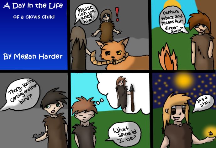
Site DatumLesson Overview: Using research information and predicting skills, students will design a six‐panel filmstrip that reflects one day in the life of a Clovis boy or girl. Objectives: * to make predictions based on facts * to make interpretive cartoon drawings *to plan and use relevant dialogue * to use a graphic organizer to plan the filmstrip Texas Essential Knowledge and Skills (TEKS): Reading (14) Reading/culture. The student reads to increase knowledge of his/her own culture, the culture of others, and the common elements of cultures. The student is expected to: (4‐8); (B) determine distinctive and common characteristics of cultures through wide reading (4‐8); and (C) articulate and discuss themes and connections that cross cultures (4‐8). Geography The student understands how people adapt to and modify their environment. The student is expected to: (A) describe ways people have adapted to and modify their environment in the United States, past and present (B) indentify reasons why people have adapted to and modified their environment in the United States, past and present, such as the use of human resources to meet basic needs; and (C) analyze the consequences of human modification of the environment in the United States, past and present. Time Frame: 1 week Vocabulary: Pleistocene ‐ [plahy‐stuh‐seen] beginning about two million years ago and ending 10,000 years ago, characterized by widespread glacial ice and the advent of modern humans Epoch ‐ [ep‐uhk] a particular period of time marked by distinctive features, events Materials: copy of requirements, filmstrip template, transparency, and rubric for each student, pencil, black pen, permanent colored markers
Input: Remember the magic of growing up . . . how part of each day was saved for
play, chores, new discoveries, endless questions? Today, childhood memories may
be immortalized in camera snapshots. What would different snapshots reveal in
one day of the life of a Clovis boy or girl?

Lesson Introduction: Think about one day in your life. What is it like? Make a list
on the board: alarm clock, bus, school, extra‐curricular activities, sports, chores,
dinner with mom and dad, homework, t.v. , etc. In designing a “snapshot” (a cartoon
panel) of one event in your day, what would the snapshot show or reveal? What
relevant dialogue or thoughts would you include?

What was it like growing up during the Pleistocene epoch some 14,000 years ago?
History books tell us that no matter what the time period, kids are kids. In many
ways, children’s lives then were similar to yours. Children probably had to be
awakened at the beginning of the day, helped prepare meals, learned skills from
their parents, had their own forms of recreation, faced dangers, experienced joy and
sorrows, had moments of wonder!

Lesson: Your job is to create a six‐panel cartoon that most accurately depicts
adventures in one day of the life of a Clovis boy or girl. Each panel must include
dialogue, a thought, or both. The panels must represent your best predictions of the
period based on facts learned. With each cartoon you should ask yourself, “Could
this really have happened?” If the answer is yes, then you’re on the right track!

Filmstrip requirements:
Panel 1: A title, a cartoon picture that reflects your title, and your printed name at
the bottom of the panel.
Panels 2 – 6: Your choice of a cartoon picture that reflects family, diet, chores,
recreation, dangers, wonderment, the future, etc. Each panel must include written
dialogue or a written thought.

Instructions:

a. Research each idea you may have about life during the period. Your research may
even present you with ideas! Record your ideas on the “Let’s Get Organized” page.
b. Use this information to plan the cartoon for each panel.
c. Use pencil to draw a cartoon on each panel of the filmstrip template. (Use may
choose to use computer graphics for the panels or scan your filmstrip and create a
powerpoint presentation). Be sure to include original dialogue or an original
thought for each panel.
d. If using pencil, trace over your lines with black pen. Erase all pencil marks.
e. Give your teacher the filmstrip to copy onto an overhead transparency.
f. Use colored permanent markers to color your panels.
g. Cut the strips and tape together.
h. Present orally to the class using an overhead projector.
You can also read