MILTON MOBILITY HUB STUDY PHASE 6: IMPLEMENTATION PLAN AND RECOMMENDED PLANNING FRAMEWORK - Town of Milton
←
→
Page content transcription
If your browser does not render page correctly, please read the page content below
MILTON MOBILITY HUB STUDY
PHASE 6:
IMPLEMENTATION PLAN AND
RECOMMENDED PLANNING FRAMEWORK

Welcome to the third public meeting for the Milton Mobility
Hub Study. In today’s meeting we will update you on the work
to date, and seek your input on the preferred planning and
development alternative for the Study Area.

Feedback
Please explore the presentation boards to learn more about the
project and the planning and development alternatives.

We encourage you to ask questions, provide feedback and fill
in a comment sheet, available at the registration table. Once
complete you can drop off comment sheets at the registration
table, or send your feedback by e-mail, mail or fax to the
contact below. Please provide any feedback by Friday, July 21st.

For further information, please contact:
David Twigg, Senior Planner
Policy and Urban Design
Planning and Development
Town of Milton, ON
L9T 6Z5
david.twigg@milton.ca

                                           Milton Mobility Hub Consulting Team
Milton Mobility Hub Study Public Open House 03_June 25 2019

STUDY PURPOSE
PROCESS & OBJECTIVES

A comprehensive study to guide the vision                     The Study contains six stages illustrated
for the Milton Mobility Hub that optimizes                    in the figure below.
the area’s potential to create transit-
oriented, pedestrian-friendly and                             Study Objectives:
sustainable neighbourhoods.
                                                              • Accommodate a mix of uses within walking distance
Study Overview                                                 of transit that will create complete, compact and
                                                               sustainable communities and the creation of a vibrant,
The Town of Milton is developing a Mobility Hub                welcoming and comfortable “gateway” destination for
Study that will support the future redevelopment               Milton;
and intensification of this area. The Study will include
a particular emphasis on making the area around               • Develop land use and transportation plans that
the Milton GO Station more pedestrian friendly and             support and prioritize pedestrians, cyclists and transit
providing better walking and cycling routes. It is             users;
critical to ensure that plans for higher density, mixed
use buildings and community uses are sensitive to             • Identify a built form that supports and promotes a
and properly integrated with the needs of established          pedestrian oriented high quality public realm and
neighborhoods and the character of downtown Milton.            architectural design excellence;

                                                              • Develop an intensification strategy that is sensitive to
                                                               stable residential neighbourhoods;

                                                              • Enable a mix of housing types that support
                                                               affordability and the attraction of a broad range of
                                                               demographics, including families;

                                                              • Identify opportunities and requirements for new or
                                                               improved community services and facilities;

                                                              • Identify future municipal infrastructure needs
                                                               and costs; and,

                                                              • Identify a system of trails and public open spaces.

R.E. Millward and Associates / Sajecki Planning
DTAH / WSP / LURA                                                                                                          2
Milton Mobility Hub Study Public Open House 03_June 25 2019

MOBILITY HUBS AND “THE BIG MOVE”
WHAT IS A MOBILITY HUB?

Mobility hubs are                                      The Milton Mobility Hub                Mobility hubs tend to be:
neighbourhoods                                         is identified as an Anchor
located around                                         Hub within Metrolinx’s                 • Located where two or
major transit                                          Regional Transportation                more regional rapid transit
stations. They serve                                   Plan. It includes the Milton           lines intersect and where
a critical function                                    GO Station and bus bays                there is expected to be
                                                       for Milton Transit. This hub           significant passenger
in the regional
                                                       is planned to integrate                activity;
transportation                                         Regional Rail, Rapid Transit
                                                                                                                                       Mobility Hubs and The Regional Transportation Plan
                                                                                                                                       A key strategy of the Province’s Regional Transportation

system as the                                          and Local Transit Service              • Forecast to achieve
                                                                                                                                       Plan is to build a network of 51 mobility hubs connecting
                                                                                                                                       the Greater Toronto and Hamilton Area.

origin, destination                                    and is identified as an                a higher density of
or transfer point for                                  area of strategic focus and            people and jobs than the
a significant portion                                  intensification.                       surrounding area; and
of trips.
                                                       Mobility Hubs are places               • Forecast to achieve 4500
                                                       of connectivity where all              or more combined peak
                                                       modes of transportation—               period boardings and
                                                       from walking to rapid                  alightings by 2031.
                                                       transit—come together
                                                       seamlessly, and where
                                                       there is a concentration of
                                                       opportunities to live, work,                                                    Elements of a Mobility Hub

                                                       shop and play.

                             Integrated                               Active                                Streets as                                              A Vibrant Mix
                             Transit                                  Transportation                        Spaces                                                  of Uses
                             Direct and weather                       Promote active                        Sidewalks with street                                   Mix of retail, employment
                             protected access                         transportation                        tree planting and street                                and residential uses will
                             between modes of                         including walking,                    furniture, fronted by                                   ensure a critical mass of
                             transit including GO                     cycling and transit.                  buildings that support a                                people live and work, and
                             Transit and                                                                    vibrant public realm.                                   play in the mobility hub.
                             Milton Transit.

                             A Connected                              Walkable                              Mixed-Use                                                Green
                             Station                                  Area                                  Buildings                                                Identity
                             New development                          Provide attractive                    Promote safe,                                            A green, safe and
                             will provide visual and                  and comfortable                       attractive streets                                       attractive place
                             physical connections                     streetscapes, trails                  and reinforce the                                        consisting of parks,
                             to the GO station and                    and parks that                        streetscape to                                           plazas and streetscapes
                             bus transit.                             encourage walking                     create a quality                                         that create a connected
                                                                      and provide places to                 pedestrian experience.                                   system and support a
                                                                      socialize and gather.                                                                          range of local social and
                                                                                                                                                                     recreational activities.

R.E. Millward and Associates / Sajecki Planning
DTAH / WSP / LURA                                                                                                                                                                                  3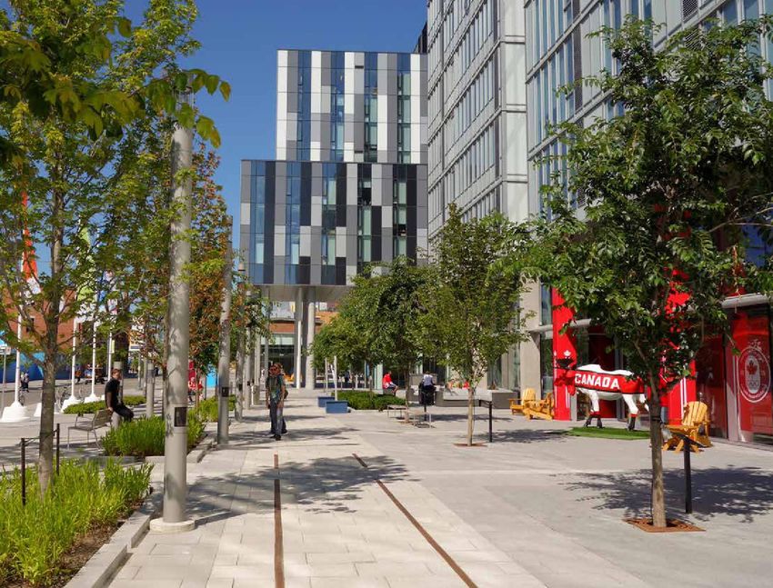
Milton Mobility Hub Study Public Open House 03_June 25 2019
POLICY CONTEXT
PROVINCIAL, REGIONAL AND LOCAL PLANNING POLICY
Plans for the Study Area are guided by the provincial, regional and local policies.
Provincial Policy Statement, 2014 • Achieving a mix of residential,
office, institutional, and commercial
Provincial The Province’s long term vision for land use development;
2014
Policy
Statement planning provides direction on the following • Providing access from various modes to
Under the Planning Act
topics, among others: the transit facility, including pedestrians,
Ontario.ca/PPS
• Using land and infrastructure efficiently bicycles and car share; and,
and protecting the environment and • Promoting innovative urban design, high
resources; quality open spaces, and an urban form
• Supporting a mix of housing, that transitions appropriately to adjacent
employment, institutional, recreational areas for intensification areas.
Growth Plan for the Greater
and open space uses with a range
Golden Horseshoe (2017)
transportation choices; and, Town of Milton Official Plan, 2008
• Focusing growth in built-up areas through
intensification and redevelopment where Key policies relevant to the MTSA/Mobility
Growth Plan for the Greater Golden Horseshoe | 97
it can be accommodated and promoting Hub include, among others:
Map 1
Regional Structure
transit-supportive development and active • Encourage transit-oriented development
transportation. with design, density and mix of uses
Approved 2015-09-28 Ballinafad
Interim Office Consolidation of the Regional Official Plan
Crewsons
32 Side Rd Corners
September 28, 2015
Hwy 7 Terra Cotta
Silver Creek
Bannockburn
ROPA 38 as Partially Approved and the Region’s Position on Parts Held for Adjudication
Henderson's
25 Side Rd Corners
OMB Hearing Case No. PL091166, PL111358 & PL110857
Glen Williams
Limehouse
which support public transit, rail/
Rd
20 Side
15 Side Rd
Note: The purpose of this document is to provide a consolidation of the Halton Region Official Plan as
Brookville
Moffat
partially approved by the Ontario Municipal Board as of the consolidation date. For those policies that Rd
Norval
remain under appeal, this document provides the Region’s position on these policies. Readers should
10 Side
Regional Rd 25
Winston Churchill Blvd
Tenth Line
Eighth Line
consult the Minister’s Decision on ROPA 38 issued on November 24, 2011 in addition to this document
Ninth Line
Trafalgar Rd
A Place to Grow: Growth Plan for the
Guelph Line
for accurate reference of those policies that remain under appeal.
interregional travel, pedestrian and bicycle
5 Side Rd
Campbellville
Steeles Ave
James Snow Pky
Greater Golden Horseshoe, 2019
Derry Rd
transportation.
Appleby Line
Kilbride
Rd
Britannia
HALTON REGION OFFICIAL PLAN [2009]
This map should be viewed Lowville
and interpreted in conjunction
with the text of the Official Plan.
* The Boundaries of the Regional
Tremaine Rd
Regional Municipality of Halton
Natural Heritage System may have
been refined in accordance Mount
with Section 116.1. Nemo
Ninth Line
Rd
Trafalgar Rd
Guelph Line
orpe
Burnhamth
Interim Office Consolidation
• Visually and physically connect the
Dundas St
Based on Amendment 38
0 1 2 3 4 Dundas St
Kilometres e Rd
Upper Middl
Fo
“An Amendment to Incorporate the Results of Sustainable Halton,
Third Line
rd
Bronte Rd
Brant St
Dr
Burloak Dr
le Rd
Upper Midd
Hwy 6
Waterdown Rd
Official Plan Review Directions and Related Matters”
St
Rebecca
Walker's Line
Plains Rd W
December 16, 2009
New St
Key Provincial policies include, among existing commercial core, Milton Mall and
Lakeshore Rd
Hamilton
As Adopted by Regional Council Harbour
Lake
Ontario
[Print Version Date: December 18, 2009] Waterfront Park (See Map 2)
Major Transit Station Greenbelt Plan Protected Countryside Boundary
Proposed Major Transit Station Urban Area Approved 2013-10-21 Niagara Escarpment Plan Boundary
Hamlet Parkway Belt West Plan Boundary
Mobility Hub
Agricultural Area Built Boundary
Rail Line
Regional Natural Heritage System * Employment Area Approved 2013-10-21
Proposed Major Arterial
others: GO Train station areas with a mix of land
Mineral Resource Extraction Area Urban Growth Centre
Major Road
North Aldershot Policy Area Area Eligible for Urban Servicing
Provincial Freeway
Greenbelt Natural Heritage System (Overlay) Halton Waste Management Site
Lot and Concession Line
Municipal Boundary
September 2, 2015
• Promoting transit-supportive and uses along Main Street. The area adjacent
pedestrian-friendly development; to the GO train station is to be a major
• Designating Downtown Milton an Urban area of mixed use development.
Growth Centre, a focus for investment, • Create a system of open spaces,
transit connections growth; linkages and nodes in conjunction with
• Supporting transit use at Major Transit development.
Station Areas through improved • Preserve and enhance built and natural
connections and a diverse mix of uses; heritage, as well as views to the
and, Escarpment. Enhance gateway areas as
• Conserving natural, cultural heritage and entry points.
The Official Plan directs growth to certain parts of Milton while
preventing it in others, with clear separation between developed
and rural areas. Compact forms of development promoted in
archaeological resources.
Urban Area.
Halton Region Official Plan, 2009 * Other City Plans and Initiatives include,
among others: The Downtown Study
Identifies Milton GO Station as a Major (2017); The Future Urban Structure Map
Transit Station Area/Mobility Hub. (2017); Milton’s First Principles of Growth
Objectives include,: (2017); and The Mid-Rise/Tall Building
Downtown Central Business District (CBD) seen as focal point of
community. Plan provides for CBD’s expansion and opportunities • Achieving increased residential and Guidelines (2018).
for redevelopment, including commercial, office, institutional,
recreational, cultural and residential uses. employment densities to support transit
service;
R.E. Millward and Associates / Sajecki Planning
DTAH / WSP / LURA 4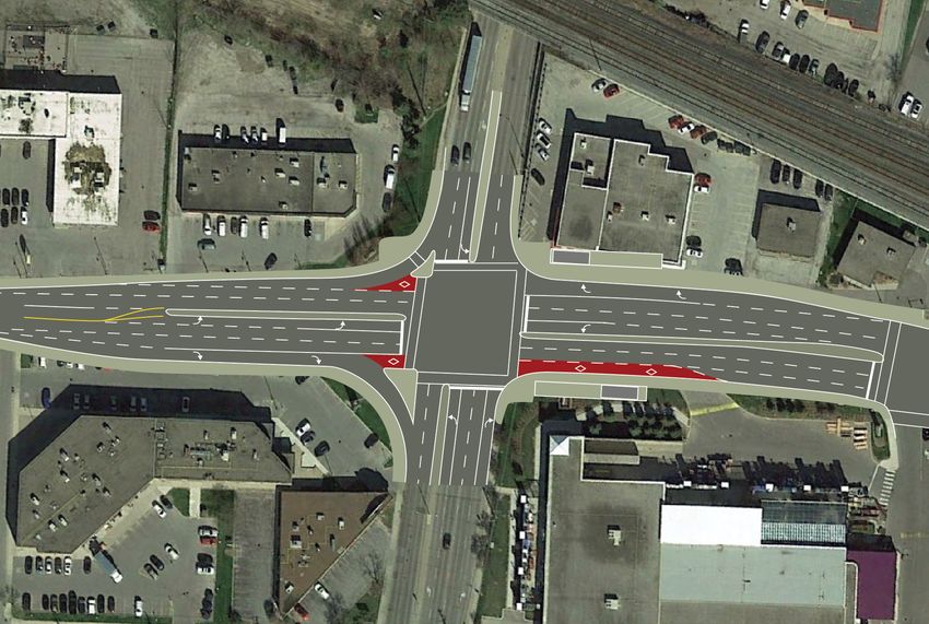
Milton Mobility Hub Study Public Open House 03_June 25 2019
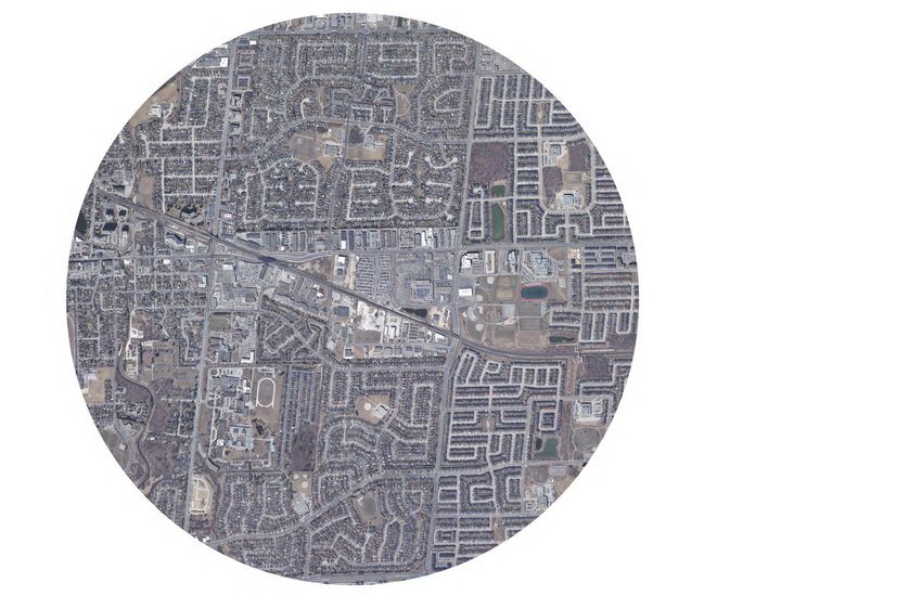
UPDATED STUDY AREA
CONTEXT
The Study Area is centred Mobility Hub boundaries are The Study Area is divided
on Milton GO Station, determined based on a 10 minute into primary, secondary and
toward the eastern end walking distance (roughly 800m) to tertiary zones, where different
of Milton’s Urban Growth the station, existing environmental transportation and land use issues
Centre, as identified in the features, infrastructure barriers and are considered. These preliminary
Growth Plan for the Greater established planning policies. boundaries are shown below.
Golden Horseshoe (2019)
This project will also consider first
and the Halton Region and last kilometer connections to
Official Plan (2009). the station as well as community
services and facilities located in the
wider catchment that could serve
the existing and future population
in the Study Area.
WOODWARD
AVE
3
ONTARIO ST
ROAD
THOMPSON
VE
WILSON DRI
CABOT TRAIL
LORNE SCOTS DR FROBISHER BLVD
MAIN STREET
MAIN STREET
MAIN STREET
ROAD
H A R R IS B LV D
T
1
ONTARIO STREE
THOMPSON
NIP
ISSI
NG
ROA
D
3
CHILDS DRIVE
DREW CENTRE
Study Area
Study Boundary
Area Boundary/ Tertiary
/ TertiaryZone
Zone
CH
1 1 Primary
PrimaryZone.
Zone.Includes thethe
Milton GOGO
Station and
ILD
2
SD
Includes Milton Station and
RI
VE
immediate surrounding areas. The area will likely
NIPISSING ROAD
immediate surrounding areas. The area will likely
be the area of greatest intensification and focus of
CHILDS DRIVE be the area of greatest intensification and focus of
public realm improvements.
public realm improvements.
COMMERCIAL STREET
3
COXE BLVD
2 Secondary Zone. Extends further along Main
2 Secondary Zone. Extends further along Main
RIVE
Street East, Thompson Road South and Ontario
L FOREST D
Street
Street East, Thompson
South. Road
This area will Southopportunities
provide and Ontario
CENTENNIA
forStreet South. Thisdevelopment.
transit-oriented area will provide opportunities
for transit-oriented development.
LAURIER AVENUE
3 Tertiary Zone. Will serve as the transition from
T
ONTARIO STREE
3 theTertiary
mobility Zone
hub .to
Will
theserve as the
broader transition from
community
0 250 500 750 1000 m
andtheitsmobility hub
focus will to thesensitive
include broader community
transitioning
ROAD
RA
VE
NU
E
0 250 and
to 500 its focus
established
750 will
1000include
neighbourhoods
m sensitive
and transitioning
improved
THOMPSON
RIE
LAU
to established neighbourhoods and improved
connectivity.
connectivity.
0 1000 100 250 250 500m
500m
Data Sources:
First Base Solutions Inc., 2018
Sources: 0 1000 100 250 250 500m
500m
Base Solutions Inc., 2018
R.E. Millward and Associates / Sajecki Planning
DTAH / WSP / LURA 5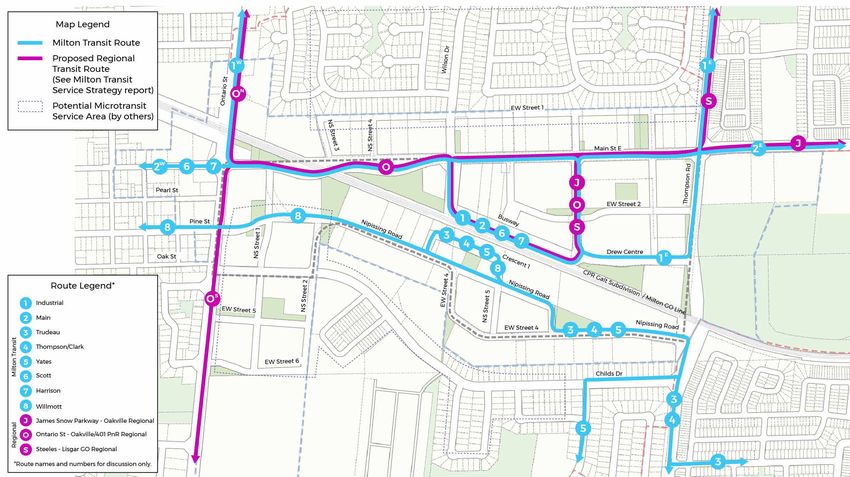
Milton Mobility Hub Study Public Open House 03_June 25 2019

VISION & GUIDING PRINCIPLES

The Milton Mobility Hub will be an innovative transit-oriented, pedestrian-friendly and
memorable destination. As the Town’s main urban centre, it will provide a mix of uses and
universally accessible public spaces that complement historic Downtown Milton, feature design
excellence, and frame views to the Niagara Escarpment. The focus will be a livable, walkable and
sustainable neighbourhood for people of all ages and abilities, with a range of opportunities to
live, work, play and connect.

The Guiding Principles have been developed based on public and agency input.

    Seamless Mobility                              Placemaking                                Successful
                                                                                              Implementation

Balanced, Safe and Efficient                      Intensification at an Appropriate          Realistic and Achievable Plan
Mobility                                          Scale and Form                             Plan for realistic growth and investment
Safely and efficiently accommodate all            Promote compact built form to              that recognizes impacts on a changing
modes of transportation for users of all          achieve a critical mass that supports      environment. Incorporate phasing
ages and abilities, with priority given to        transit and the efficient use of land      strategies to account for long-term
the most vulnerable users.                        by meeting minimum density targets.        growth and market changes, as well
                                                  Focus intensification within the primary   as measures to evaluate and monitor
Strong Visual and Physical                        zone, and provide appropriate built        implementation progress.
Connectivity                                      form and public realm transitions to
Provide a network of streets, parks,              minimize impacts on stable residential     Strategic and Holistic Approach
paths and open spaces to form a                   neighbourhoods to the north and south.     to Parking Supply
convenient and inviting public realm                                                         Provide an appropriate supply of
connecting the GO Station, local transit          Mix of Uses within the Primary             parking that meets the needs of users
routes and key community destinations.            and Secondary Zones                        but does not act as a disincentive
New pedestrian connections will link              Provide a mix of uses within to create     to using transit. Encourage reduced
the north and south sides of the rail             a vibrant complete community that          parking and maximize opportunities
corridor.                                         supports existing and future planned       for shared parking. Minimize surface
                                                  conditions and transit infrastructure.     parking and ensure surface parking can
Walkable and Inviting Streets,                                                               transition to other uses over time.
Parks and Open Spaces                             Design Excellence
Create a green, safe and attractive               Ensure all new public and private sector   Partnerships and Innovative
place with public parks, promenades,              development (including buildings,          Solutions
high quality streets and privately owned          infrastructure, streetscapes and open      Seek public-private partnerships to
publicly-accessible open spaces that are          spaces) is well-designed, embraces low-    advance new development. Explore
sited and designed to promote walking             impact development practices, delivers     innovative approaches to building
and support a range of local social and           street-level animation, and makes use of   science, flood management, parks and
recreational activities.                          high-quality materials.                    open spaces, community services and
                                                                                             facilities and transportation technology.

R.E. Millward and Associates / Sajecki Planning
DTAH / WSP / LURA                                                                                                                     6
Milton Mobility Hub Study Public Open House 03_June 25 2019
Milton Mobility Hub Study Public Open House 03_June 25 2019
Milton Mobility Hub Study Public Open House 03_June 25 2019
WHAT WE HEARD FROM THE COMMUNITY
MILTON MOBILITY HUB STUDY:
MILTON MOBILITY HUB STUDY:
WHAT WE HEARD FROM THE COMMUNITY
WHAT WE HEARD FROM THE COMMUNITY
Milton wants a mobility Hub that provides:
Milton wants a mobility Hub that provides:
1. Safe Mobility
1. Safe Mobility
Improve safety for people walking, cycling, driving and taking transit.
Improve safety for people walking, cycling, driving and taking transit.
2. Increase Connectivity and Easy Navigation
2. Increase Connectivity and Easy Navigation
Create more walkways, improve transit service, improve connectivity
Create
between more walkways,
buildings and addimprove
cleartransit service,
directional improve connectivity
signage.
between buildings and add clear directional signage.
3. Inviting Streets, Parks and Open Spaces
3. Inviting Streets, Parks and Open Spaces
Make the streetscape more inviting, exciting and enjoyable for
Make the streetscape
pedestrians by addingmoremoreinviting,
publiclyexciting andspaces
accessible enjoyable
andforhosting
pedestrians by adding
community events morespaces.
in these publicly accessible spaces and hosting
community events in these spaces.
4. Balanced Growth
4. Balanced Growth
Concentrate growth along Main Street East and the rail corridor.
Concentrate growth
Transition building along Main
heights Street
as they East and
approach the rail corridor.
neighbouring low-rise
Transition
residential building
areas. heights as they approach neighbouring low-rise
residential areas.
5. Mixed-use Development
5. Mixed-use Development
Create walkable communities by encouraging developments that
Create
include walkable
spaces tocommunities
live, work and byplay
encouraging developments
(e.g. homes, that
offices, shops,
include
doctors’spaces
offices,to live, worketc.).
daycares, and play (e.g. homes, offices, shops,
doctors’ offices, daycares, etc.).
6. Design Excellence
6. Design Excellence
Create unique and functional spaces by encouraging sustainable
Create uniquethat
development andhasfunctional
characterspaces by encouraging
and meets the needssustainable
of residents.
development that has character and meets the needs of residents.
7. Necessary Infrastructure
7. Necessary Infrastructure
Ensure infrastructure capacity keeps up with the needs of the
Ensure
growinginfrastructure
population bycapacity
providingkeeps
newup with the needs
community of the
services, improving
growing population
transportation by providing
and publicly new community
accessible spaces. services, improving
transportation and publicly accessible spaces.
8. Parking Supply
8. Parking Supply
Provide adequate parking while encouraging more active
Provide adequate
transportation like parking
walkingwhile encouraging
and cycling. more the
Encourage active
use of parking
transportation like walking
lots for community events whenand cycling.
they areEncourage the use of parking
not at capacity.
lots for community events when they are not at capacity.
9. Partnerships and Innovative Solutions
9. Partnerships and Innovative Solutions
Work together with the private sector to provide community benefits
Work together
like shared withfacilities
parking the private
andsector to provide community
privately-owned public spaces.benefits
R.E. Millward and Associates / Sajecki Planning
like shared parking facilities and privately-owned public spaces.
DTAH / WSP / LURA 7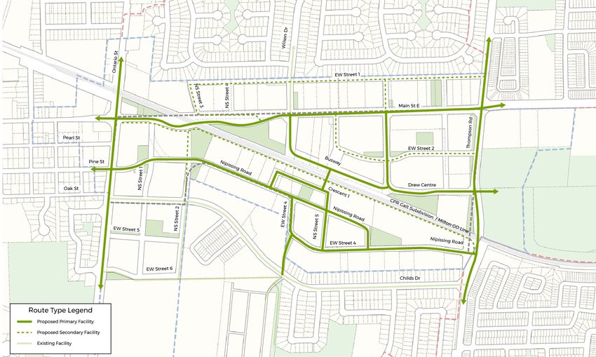
Milton Mobility Hub Study Public Open House 03_June 25 2019
URBAN DESIGN STRATEGY
OBJECTIVES
New developments should
contribute to the establishment
of a strong sense of place and the
increasing sustainability of Milton’s
built and natural environment.
Main Street
Cultural +
The key urban design objectives Historic
Community Hub
Downtown
are to develop a compact, transit- Milton
GO
Lions Sports
oriented and pedestrian friendly
Park
neighbourhood with a mix of uses Nipissing Rd
and a variety of housing choices,
dS
S
Thompson R
Ontario Rd
employment, and supporting
services and facilities. Centennial
Forest
Park
Study Area: Primary Zone
The Urban Design Strategy on Study Area: Secondary Zone
Study Area: Tertiary Zone
the following panels emphasizes Existing Open Space
Potential Streets
a connected and complete Potential Green Streets
community focused around the Big Moves Gateways
GO Station with a strong green
character and mix of uses that
reinforces the role of this area as a Milton GO
regional transit hub. Station Milton GO
Station
r e
t
en e
C t r
w
r e en
D C
ew
r
D
Ma
in S
t ree
t Ma
in S
t ree
t
Existing Station Area with Proposed Metrolinx Plan. The GO lands are one of the There are opportunities for the surface parking areas within the GO lands to
largest single ownership properties within the Study Area. evolve and better connect itself to the surrounding street network incrementally
over time.
Plaza at West Harbour GO Station, Hamilton Orenco Station, Hillsboro, OR
R.E. Millward and Associates / Sajecki Planning
DTAH / WSP / LURA 8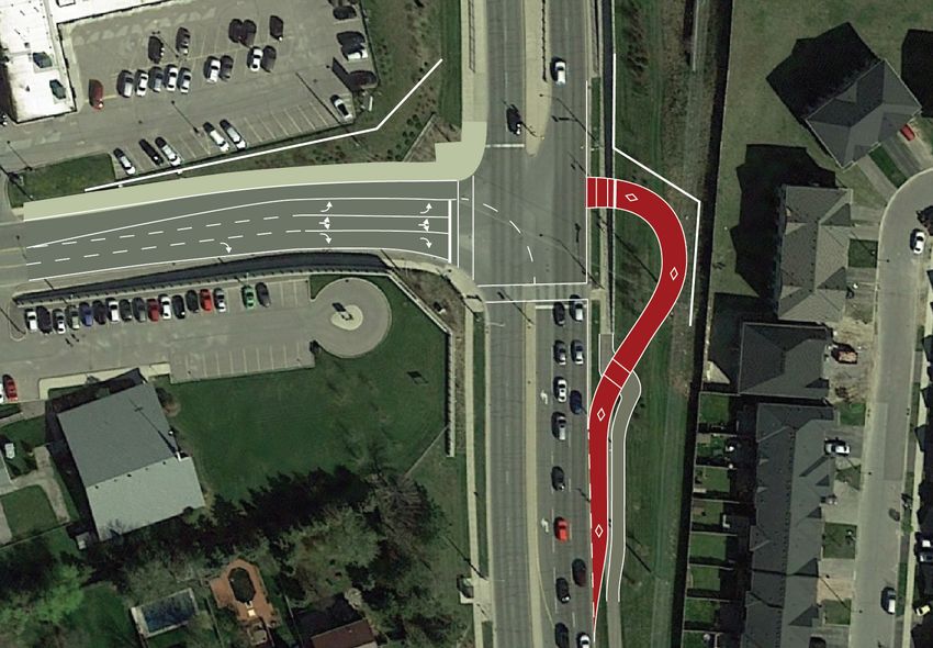
Milton Mobility Hub Study Public Open House 03_June 25 2019
URBAN DESIGN STRATEGY
STREETS AND BLOCKS
Woodward
Woodlot
Centre
Park
Court D
Park Nei
dS R
The Milton Mobility Hub Study
Thompson
is exploring ways to increase
Wilson Dr
S
Ontario St
transportation choice to reduce
reliance on the car. This includes
adding new streets, walkways, lanes Main Street
Milton Centre
and path connections to create
for the Arts/
Library
more choices for how people move Historic
Downtown
through the area and strengthen Drew Centre
pedestrian and cycling connections Lions Sports
Park
to the GO Station.
Milton
Nipissing Rd
Evergreen
The streets and blocks
Cemetery
Study Area: Primary Zone
Study Area: Secondary Zone
recommendations include: Childs Dr Study Area: Tertiary Zone
Existing Open Space
Existing Streets
Proposed Streets
( Secondary Plan, Metrolinx Plan,
• Nipissing extension; Wilson Drive Coxe
Blvd Park
Regional Ontario St. Property Master Plan)
Potential Public Streets
Transit Promenade; and a new Proposed Connections
( Secondary Plan,
Regional Ontario St. Property Master Plan)
Public Street north of Main Street; Centennial
Potential Connections
(Streets, Paths, Mid-blocks)
Transit Hub
Forest Park
Existing Signalized Intersection
• new streets, paths, and lanes Proposed Signalized Intersection
contributing to a fine grained Linkages + Connections Diagram
street and block network;
Evolution of the Milton Street + Block Grid
• streets located to provide The historic street and block
pattern of downtown Milton,
improved physical and visual located just to the west of the
Study Area is comprised of a
connections to the GO walkable network of blocks
with intersections spaced at
Main Street
80m
station; and around 80m. The framework
Drew Centre
plans adapt the historic block
pattern grain through a pattern
80m
of development blocks with a Approx.
fine grain of public streets, public 80m
• a pattern of streets and mid-block and publicly-accessible lanes
and walkways. The blocks are
connections to form urban scaled dimensioned to accommodate
a wide range of development
walkable blocks that are approx. models and building types yet
promote a more predictable
80m to 150m (similar to other urban form.
transit-supportive areas). Milton’s historic pattern of street and blocks Adapting Milton’s historic urban for the Mobility Hub through
a combination of streets and mid-block connections spaces at
approximately 80m.
Thompson
Ontario
Drew
Proposed Main Street Connections
Main Street
Existing
450m 900m 150m
Main Street
Proposed
150m 100m 200m 100m 100m 200m 450m 100m Existing
100mStreets
150m
Existing Pedestrian Connections
A pattern of streets and mid-block connections to form urban Existing Streets Proposed New Streets
scaled walkable blocks that are approx. 80 to 150m
Existing Pedestrian Connections Proposed Pedestrian Connections
Proposed New Streets
R.E. Millward and Associates / Sajecki Planning Proposed Pedestrian Connections
DTAH / WSP / LURA 9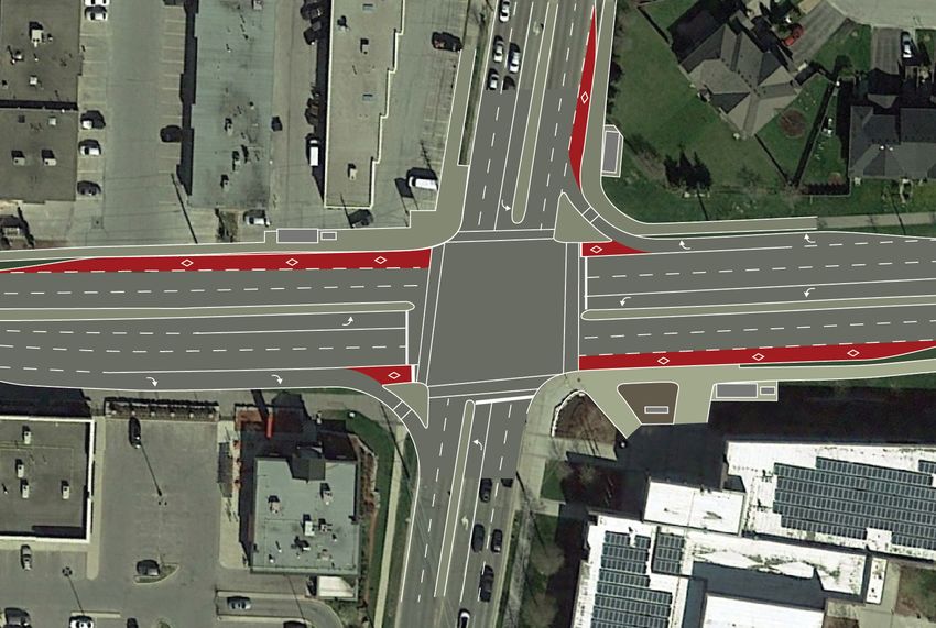
Milton Mobility Hub Study Public Open House 03_June 25 2019
URBAN DESIGN STRATEGY
PUBLIC REALM (PARKS & PRIVATELY-OWNED PUBLIC SPACES)
Woodward
Woodlot
Centre
Park
Court D
Park Nei
Rd S
High quality parks, open spaces,
Thompson
plazas and streets are a critical
Wilson Dr
S
component of a complete
Ontario St
community. New parks and open
Main Street
spaces will provide additional Milton Centre
greening, support community
for the Arts/
Library
vitality and complement and Historic
Downtown
Lions Sports
connect with Lions Sports Park,
Park
Drew Centre
located just to the east of the
MTSA.
Nipissing Rd
Milton
Evergreen Study Area: Primary Zone
The public realm strategy identifies
Cemetery
Study
StudyArea:
Area:Secondary Zone
Primary Zone
Study
StudyArea:
Area:Tertiary ZoneZone
Secondary
the recommended locations for Childs Dr Existing OpenTertiary
Study Area:
Potential
Space Zone
Existing Streets
Open Space
new open spaces and public realm Potential
PotentialGreen
Bus
Connection?
Streets
Only Route
Potential Green Connection
improvements. These may include Coxe
Blvd Park
Transit
TransitHub
Potential
Hub and Transit Plaza
PotentialConnections
Connections
a combination of privately and
(Streets,
(Streets,Paths,
Paths,Mid-blocks)
Mid-blocks)
Existing / Potential Trails, Paths
Street Greeening
and Cycling Connections
publicly owned spaces. The key
Main Street Revitalization
Street Greeening
Potential Parks/ POPS
Potential Parks
Centennial
recommendations include: Forest Park Potential Plazas/ POPS
Potential Plazas/ POPs
Potential Community Nodes
Main Street Revitalization
Gateways
Downtown Gateway
• new parks and plazas on large Public Realm Diagram
development sites; Main Street Focus Gateways
Main Street East connects the Community and Cultural District in the east to Three new gateways containing urban plazas and special built form expression
the historic downtown in the west. Main Street East is envisioned as a landmark are proposed to create a sense of arrival and departure from the Mobility Hub:
• three new gateways creating a street and a central focus of the Study Area • The GO Station Gateway: new urban plaza’s related to creating a sense of
arrival/ departure from the GO Station;
sense of arrival and departure • The Western Gateway: Built Form and Public Realm to mark the entrance to
historic downtown.
• The Eastern Gateway: New built form and plaza to signify entrance.
from the Mobility Hub;
• mid-block connections and
“green fingers” providing cycle
and walking connections;
• streetscape improvements
including improved boulevard
treatments along Ontario and
Thompson Streets;
Parks Plazas Main Street Revitalization
• Main Street revitalization; and
• a new green street connection
linking Main Street, the GO
Station and Lions Sports Park.
Mid-block connections Streetscape Improvements Green Street Connection
R.E. Millward and Associates / Sajecki Planning
DTAH / WSP / LURA 10Milton Mobility Hub Study Public Open House 03_June 25 2019
URBAN DESIGN STRATEGY
BUILT FORM STRATEGY
Kinsmen Park
Woodward
Woodlot
Centre
Park Dempsey
Court Neighbourhoo
Park Park
Rd S
Building design influences the
Thompson
character and quality of the
Wilson Dr
S
public realm and pedestrian
Ontario St
environment. Building height,
Main Street
location, proportionality with
abutting streets and transitions
Milton Centre
for the Arts/
Library
to existing neighbourhoods are
key considerations. The built form Drew Centre
strategy includes:
Lions Sports
Park
• a variety of building types Nipissing Rd
including low-rise buildings and Milton
Evergreen
Cemetery
townhouses, mid-rise buildings Childs Dr
and tall buildings. Mid-rise
buildings are the predominant Coxe
Blvd Park
building type within the Study Study Area: Primary Zone
Area; Centennial
Study Area: Secondary Zone
Study Area: Tertiary Zone
Forest Park
Low- Rise (1-4 storeys)
• the greatest building heights
Mid-Rise (5-8 storeys)
Tall Building (8+ storeys)
are reserved for three landmark Built Form Strategy
locations- Thompson Road at
Drew Centre; Ontario Street at Streetwalls Floor Plate control
above 8 storeys
Main St East and at the new GO 8 storey max. mid-rise
station location;
building height
3m min. stepback 3m min. stepback
Maximum Streetwall height Maximum Podium height
6 st. 6 st.
• built form transitions in height,
scale and intensity to stable 4 storey max. low-rise
building height
Minimum Streetwall height
4 st.
Minimum Podium height
4 st.
residential neighbourhoods to the
north and south;
4.5m 4.5m Ground Floor 4.5m
Ground Floor min.
min. Retail min. Retail
• locating new buildings closer
to the street edge with active Setback Boulevard Street
3m
Setback Boulevard Street
varies
Setback Boulevard
varies
Street
ground floor uses to define
PL
PL PL
Low-Rise Mid-Rise Tall Building
and animate streets and public
spaces;
• new buildings are to conform to
Milton’s Urban Design Guidelines
for tall and mid-rise buildings; and
• building design that support a
diverse mix of use and allow for
flexibility.
These range of precedents illustrate best practice examples of how new
buildings can animate the public realm through active frontages and mixed use.
R.E. Millward and Associates / Sajecki Planning
DTAH / WSP / LURA 11Milton Mobility Hub Study Public Open House 03_June 25 2019
URBAN DESIGN STRATEGY
DENSITY STRATEGY
What is Density?
The number of people or jobs in
an area. Higher density supports Building
a greater variety of uses within
walking distance.
Site Site 2 Storeys 4 Storeys 8 Storeys
Higher density doesn’t always 100% Coverage 50% Coverage 25% Coverage
equal taller building. In the Density = Site Area Kinsmen Park
2.0x FSI 2.0x FSI 2.0x FSI
diagram to the right, all three Floor Area
buildings have the same gross area, Centre
Woodward
Woodlot
and represent the same Floor Space
Park Dempsey
Court Neighbourhoo
Park Park
Rd S
Index (FSI) if constructed on the
Thompson
same land size.
Wilson Dr
S
Ontario St
All three buildings to the right have Main Street
an FSI of 2.0, which means that Milton Centre
the area of the floor space in the
for the Arts/
Library
buildings is equal to 2.0 times the
size of the land on which is built. Drew Centre
Lions Sports
Park
Density Strategy Nipissing Rd
Milton
Evergreen
Cemetery
The density within the study area
Childs Dr
Study Area: Primary Zone
ranges from 1.0x - 6.0x FSI. Study Area: Secondary Zone
Coxe
Blvd Park
Study Area: Tertiary Zone
Highest density are concentrated 1.0-2.0 FSI
around the station area and along Centennial
1.5-3.0 FSI
the train tracks. Lower density
Forest Park
3.0-5.0 FSI
areas are located adjacent to the 3.0-6.0 FSI
stable residential neighbourhood Density Strategy
to the north and south.
Low-Rise Mid-Rise Tall Buildings
Rivertowne, Toronto Ideal Lofts, Toronto Radio City, Toronto
FSI: 1.6 FSI: 5.4 FSI: 6.4
R.E. Millward and Associates / Sajecki Planning
DTAH / WSP / LURA 12Milton Mobility Hub Study Public Open House 03_June 25 2019
URBAN DESIGN STRATEGY
MIX OF USES TO SUPPORT A COMPLETE COMMUNITY
Kinsmen Park
Woodward
Woodlot
Centre
Park Dempsey
Court Neighbourhoo
Park Park
A complete community is a place
that meets people’s needs for daily
Rd S
Wilson Dr
S
Thompson
living at any stage of life by providing
Ontario St
convenient access to a mix of jobs,
Main Street
local businesses, community services
and infrastructure such as a range of
Milton Centre
for the Arts/
Library
housing and transportation options,
schools, and community, cultural Drew Centre
and recreational activities. Lands in
the study area are primarily zoned Lions Sports
Park
as Urban Growth Centre Mixed Nipissing Rd
Study Area: Primary Zone
Use, which provides a broad mix Milton
Evergreen
Cemetery
Study Area: Secondary Zone
Study Area: Tertiary Zone
of compatible uses. Key land use Childs Dr
Existing Open Space
Potential Streets
Study Area: Primary Zone
recommendations include: Potential
Bus Only
Study
Green
Study Area:
Route
Area:
Connection?
Secondary Zone
Tertiary Zone
Coxe Transit Hub
Existing Open Space
Blvd Park
Potential
Mixed-useConnections
• integrating transit facilities with
(Streets, Paths, Mid-blocks)
Residential
Existing / Potential Trails, Paths
and Cycling Connections
Institutional/ Community
other uses such as plazas, shops Centennial
Street Greeening
New Parks
Potential Parks
Active Frontages
(including grocery stores), cafes, Forest Park
Potential
PotentialPlazas/
Main
MainStreet
POPs
Connections
StreetRevitalization
residential and community services; Mix of Uses
Transit Hub and Transit Plaza
Downtown Gateway
• enhancing connections to existing
community facilities, including
opportunities to expand and
connect to the existing open space
system.
• animating the streets and public
open spaces with active grade
related buildings;
• grade related retail uses along Main Integration of transit facilities with other retail, commercial, office, cultural and residential spaces. Parallel retail street
Street to animate the streetscape
and provide a central focus of the
Study Area;
• potential for a parallel retail street
to provide a retail connection to the
GO Station; and
• encouraging a mix of uses within
individual buildings such as retail,
restaurants, office, institutional,
cultural and residential spaces.
Range of ground floor commercial and retail uses animating an urban A walkable mixed use neighbourhood combining places to live, work, play and shop.
square.
R.E. Millward and Associates / Sajecki Planning
DTAH / WSP / LURA 13Milton Mobility Hub Study Public Open House 03_June 25 2019
STREETSCAPE
Main Street
35.0m ROW
As the area redevelops the roads will Strong green character & public realm emphasis
Wide boulevards & street tree planting
evolve into streets that are places for Cycle tracks
Curb side activities to support adjacent land uses
people to live, work, shop and play
through an enhanced pedestrian
Public Right-of-Way
Public Right-of-Way
and cycling network. The framework
plans incorporate a Complete Streets
Active Uses at Grade
Active Uses at Grade
approach to street design.
North South
P P
The complete streets approach 3.0m
Clear Sidewalk
3.0m
Furnishing + Planting
8.3m
Cycle Track
1.8m 0.5 2.4m
Curb Extension
3.5m
Travel Lane
3.3m
Travel Lane
18.4m
3.3m
Travel Lane
3.5m
Travel Lane
2.4m
Curb Extension
0.5 1.8m
Cycle Track Furnishing + Planting
3.0m
8.3m
Clear Sidewalk
3.0m 2.0m
Planting Zone
4.0m
Setback
describes streets as both links and
Boulevard Travelway Boulevard
35.0m
Right-of-Way
places, providing greater choice for
how people will enliven the public
realm and manage congestion. It Ontario and Thompson Street
35.0m ROW
is well understood that with this Strong green character & public realm emphasis
Wide boulevards & street tree planting
approach, cities become more Cycle tracks
Large landscape setbacks
resilient and efficient.
Public Right-of-Way
Public Right-of-Way
Within the study area, a range of
street cross sections have been
Active Uses at Grade
Active Uses at Grade
developed for each type of street.
The street cross sections demonstrate
the preferred typical street design. Varies
Setback
3.0m
Clear Sidewalk Furnishing + Planting
9.2m
3.9m
Cycle Track
1.8m 0.5 3.5m
Travel Lane
3.3m
Travel Lane
3.0m
Turn Lane / Median
16.6m
3.3m
Travel Lane
3.5m
Travel Lane
0.5 1.8m
Cycle Track
3.9m
Furnishing + Planting
9.2m
3.0m
Clear Sidewalk
Varies
Setback
Boulevard Travelway Boulevard
35.0m
Right-of-Way
Local Street
20.0m ROW
Residential Frontages
Parking on one side or both sides
Shared on street cycling
Public Right-of-Way
Public Right-of-Way
Active Uses at Grade
Active Uses at Grade
P P
3.0m 2.1m 2.2m 2.4m 3.3m 3.3m 2.4m 2.2m 2.1m 3.0m
Setback Clear Sidewalk Furnishing + Planting Curb Extension Turn Lane Turn Lane Curb Extension Furnishing + Planting Clear Sidewalk Setback
4.3m 11.4m 4.3m
Boulevard Travelway Boulevard
20.0m
Right-of-Way
Complete Streets
Boulevards Cycling Crosswalks and Crossings Transit
R.E. Millward and Associates / Sajecki Planning
DTAH / WSP / LURA 14Milton Mobility Hub Study Public Open House 03_June 25 2019
TRANSPORTATION FINDINGS
WALKING AND CYCLING
The envisioned future cycle
infrastructure map is illustrated to the
right. All streets will have sidewalks
on both sides of the street and
walking and cycling facilities will
be greatly improved from existing
conditions with new connections and
more facilities.
Infrastructure will consist of parallel-
to-street cycle tracks, multi-use paths,
bicycle lanes and off-street paths and
connections.
It is anticipated that the Milton GO
Station tunnel will become a non-fare
paid area to connect the north and
south sides of the rail corridor.
An off-street path adjacent to the Sample facility treatments
rail corridor will provide views of the Rail Corridor/ Separated Sample Integrated
Escarpment and cross-transportation Off-Street Trail Bicycle/Sidewalk
Treatment
utility without venturing onto busy
roads.
Potential Intersection Marked cycle tracks and
Treatment sidewalks, delineated
parking
R.E. Millward and Associates / Sajecki Planning
DTAH / WSP / LURA 15Milton Mobility Hub Study Public Open House 03_June 25 2019
TRANSPORTATION FINDINGS
PUBLIC TRANSIT
The envisioned transit route map for
the future is illustrated to the right
and includes both Milton Transit and
Regional services.
It is anticipated that buses will run on
frequencies between 5 to 15 minutes
on each route (many more buses
than today). GO Rail is envisioned to
provide two-way all-day service.
Local surface transit (bus routes) are
anticipated to receive priority (lanes
and signals) at key intersections:
• Main Street and Thompson Road
• Main Street and Ontario Street
• Main Street and Wilson Drive Potential transit priority treatments
Main Street and Main Street and
• Nipissing Road and Thompson Thompson Road Ontario Street
Road
Nipissing Road and Main Street and
Thompson Road Wilson Drive
Buses turn left
Buses proceed using a dedicated
through on transit signal
their own
green light
R.E. Millward and Associates / Sajecki Planning
DTAH / WSP / LURA 16Milton Mobility Hub Study Public Open House 03_June 25 2019
TRANSPORTATION FINDINGS
VEHICLE TRAFFIC
Vehicle traffic will be busier in the
future, especially at key intersections
on Main Street, Thompson Road and
Ontario Street. Operations at key
intersections are shown for existing
and future conditions.
It is anticipated that some or most
vehicle traffic demand for GO Transit
will be diverted to another station.
The introduction of increased transit
service, more walking and cycling Existing Traffic
facilities, transportation demand
measures and new streets are key to
managing future traffic volumes.
Roadway widths will vary from 2 to 4
lanes wide.
Future Traffic
Roadway Cross Section
R.E. Millward and Associates / Sajecki Planning
DTAH / WSP / LURA 17Milton Mobility Hub Study Public Open House 03_June 25 2019
WATERSHED HYDROLOGY AND
STORMWATER MANAGEMENT (SWM)
Stormwater Management (SWM)
Design Criteria
Conservation Halton Policies and
Guildlines for the Administration of
Ontario Regulation 162/06
• SWM Planning and Design Manual,
MOECC, March 2003
• Flood / Water Quantity Control:
Reduce post-development peak
flows to pre-development peak Watershed-based Hydrological Modelling – HSPF
flows for 2- to 100- year design
storm events.
• Erosion Control: Detain and
release of the 25mm design storm
over a 24-hour to 48-hour period.
• Quality Control: “Enhanced” level
of water quality treatment (80% TSS
reduction)
Watershed-based Hydrological
Modelling – HSPF (Continuous
Simulation)
• The results confirm that there
would be no negative hydrological
impacts to the upstream and
downstream areas.
SWM Analysis on Site Level –
PCSWMM (Event-based dual
drainage system)
• Determination of the Required
SWM Controls
SWM Analysis on Site Level – PCSWMM
R.E. Millward and Associates / Sajecki Planning
DTAH / WSP / LURA 18Milton Mobility Hub Study Public Open House 03_June 25 2019 WATERSHED HYDROLOGY AND STORMWATER MANAGEMENT (SWM) Stormwater Management (SWM) Strategy Traditional Approach – End-of-pipe SWM Controls: • Water Quantity Control: End-of- pipe Detention Storage System (e.g., SWM Pond, Underground Tank, etc.) • Water Quality Control: Oil Grit Separator (e.g., Imbrium’s Stormceptor, etc.) Innovative Mitigation Measures - Low Impact Developments (LIDs) via Treatment Train Approach (a combination of source controls, convey controls and end-of-pipe controls). • Implementation of LIDs to provide 18mm (preferred) or 5mm CULTEC Subsurface Chamber at Parking Lot Modular Bioretention/Wetland System (recommended) of runoff retention for the development area. • State-of-the-art SWM strategy to help maintain predevelopment hydrologic regime and watershed ecosystem by creating equivalent hydrologic landscape • LID application samples: Infiltration Trench or Chamber, Bioretention Product (Surface or Subsurface), Bioswale, Water Reuse / Greywater Recycling for commercial buildings, Green Roof at the Proposed Kipling Mobility Hub Green Roof R.E. Millward and Associates / Sajecki Planning DTAH / WSP / LURA 19
Milton Mobility Hub Study Public Open House 03_June 25 2019

UTILITIES
WATERMAIN NETWORK

Proposed watermain network in the
Primary Study Area – new mains
added along proposed street and
upgrades proposed along existing
streets.

• Thompson Rd. N.: Replace the
  300mm main with a 400mm main
  (extending the existing 400mm stub
  south approximately 500 m);

• Main St. E.: Replace the 300mm
  main with a 400mm main
  (extending the existing 400mm stub
  east approximately 700m);

• Upsize the 150mm Pine St. main
  to a 200mm main – approximately
  450m;

• Upsize the 150mm Pearl St. main
  to a 200mm watermain from
  Ontario St. N. to Court St. S. and
  the 150mm Court St. S. main to a
  200mm main from Pearl St. to Main
                                                  The results presented above reflect the network pressures with all of the existing infrastructure – no new mains or upgrades have been considered.
  St. E. – approximately 350m.

                                                  The results presented above do no consider the system upgrades presented in bullets 1 through 4. They only consider new mains along new streets. When the system
                                                  upgrades are considered pressures are slightly higher, but headloss in mains is considerably better.

R.E. Millward and Associates / Sajecki Planning
DTAH / WSP / LURA                                                                                                                                                                                                    20
Milton Mobility Hub Study Public Open House 03_June 25 2019 UTILITIES WATERMAIN NETWORK Proposed sewer network in the Primary Study Area – New sewers added along proposed street and upgrades proposed along existing street below: • Nippising Rd. and Childs Dr.: Approximately 1,075m of sewers are recommended as upgrades. The existing 300mm sewer upsized to 380mm and the existing 380mm sewer upsized to 450mm. • Ontario St.: Approximately 420m of sewers are recommended as upgrades. The existing sewer is 250mm. • Evergreen Cemetery to Fulton SPS: The sewers would need both slope improvement and size increase for a total length of 175m. The existing sewer is 250mm. • Thompson Rd. S.: A small stretch of sewers would need re-sloping and upsizing for an approximate length of 115m. The existing sewer is 300mm. • Sewers between Fulton St. and Ontario St. N.: Approximately 700m of sewers are recommended as upgrades The existing 675mm sewers upsized to 750mm. • Childs Dr. upstream of Fulton St.: Approximately 525m of sewers are recommended as upgrades. Sewers would need upsizing from the existing 450mm to 500mm and 600mm diameter sewers. R.E. Millward and Associates / Sajecki Planning DTAH / WSP / LURA 21
Milton Mobility Hub Study Public Open House 03_June 25 2019

VISUALIZATIONS
STATION PLAZA

Station Plaza Visualization on the North Side

The Milton GO Station will be a key
destination in the City and have
a strong presence in the urban
landscape, seamlessly integrating
different modes of transportation and
offering safe, convenient and visible                                                                      Milt
                                                                                                               on
                                                                                                                    GO
pedestrian links to nearby jobs, retail
and housing. New urban plazas with
active grade related buildings are                                                    M ain
                                                                                              St re
proposed at both station entrances                                                                    et

to support a vibrant place of public
interaction around the station.
                                                                                                                            Main
                                                                                                                                   Str

                                                  Station Plaza: Demonstration Plan
                                                                                                                         View

R.E. Millward and Associates / Sajecki Planning
DTAH / WSP / LURA                                                                                                         22
Milton Mobility Hub Study Public Open House 03_June 25 2019
VISUALIZATIONS
MAIN STREET
Main Street Visualization
Main Street East connects the Community
and Cultural District in the east to the historic
downtown, just west of the Study Area. Main
Street East is envisioned as a landmark street
and central focus of the Mobility Hub with
et
street tree planting, widened sidewalks, cycling
re
St
n
infrastructure, supportive building frontages,
ai
M
and consistent paving treatment.
Main Street: Demonstration Plan
et
re
St
n
ai
R.E. Millward and Associates / Sajecki Planning
Tho
M
23
DTAH / WSP / LURA
mpMilton Mobility Hub Study Public Open House 03_June 25 2019
DEMONSTRATION PLANS
The demonstration plans
Milton GO
illustrates one possible Station
outcome if the principles
and recommendations
from this study are
applied to a full build-
out condition. The
demonstration allows
for flexibility and several
different outcomes. Lions Sports
Park
The demonstrations
et
re
St
represents approx.
n
ai
Tho
M
mp
son
4500 jobs and 30,000 Milton Centre for Ro
ad
the Arts/ Libray
residents.
Demonstration Plan looking towards South East
Lions Sports
Park
Rd
ing
ss
pi
e
riv
Ni
sD
ild
Ch
Milton GO
Station
et
re
St
a in
M
On
tar
io
St
ree
t
Demonstration Plan looking towards North West
R.E. Millward and Associates / Sajecki Planning
DTAH / WSP / LURA 24Milton Mobility Hub Study Public Open House 03_June 25 2019
Milton Mobility Hub Study Public Open House 03_June 25 2019
COMMENTS BOARD
What do you like about the proposed plan for the Milton
Mobility Hub?
What would you change about the proposed plan for the Milton
Mobility Hub?
R.E. Millward and Associates / Sajecki Planning
DTAH / WSP /and
R.E. Millward LURA
Associates / Sajecki Planning
DTAH / WSP / LURA 25MILTON MOBILITY HUB STUDY
NEXT STEPS
Your input is important to help shape the Study’s
recommendations. There are many opportunities to
provide input into the Milton Mobility Hub Study.
Please watch the project website for updates and chances
for additional input.
Coming Up
Final Recommendations Report: Summer 2019
Council Policy Directions Report: Fall 2019
For further information, please contact:
David Twigg, Senior Planner
Policy and Urban Design
Planning and Development
Town of Milton, ON
L9T 6Z5
david.twigg@milton.ca
MTSA and Mobility Hub Consulting TeamYou can also read