MISSOURI STATE EMERGENCY MANAGEMENT AGENCY - Current Conditions Last Update: 09:13 4/9/2019
←
→
Page content transcription
If your browser does not render page correctly, please read the page content below
MISSOURI STATE EMERGENCY MANAGEMENT AGENCY

                                                       Current Conditions
                                                        Last Update: 09:13 4/9/2019

 Email: MOSEMA@sema.dps.mo.gov   Phone: 573-526-9100              Toll-Free: 800-298-6289

4/9/2019                         www.sema.dps.mo.gov   @MoSEMA_           MissouriSEMA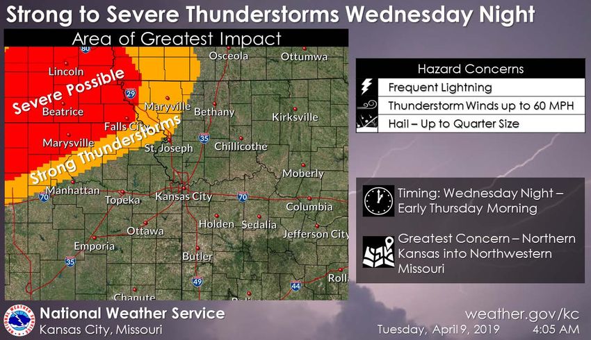
NATIONAL WATCHES, WARNINGS, & ADVISORIES

4/9/2019
4/9/2019

WATCHES, WARNINGS, & ADVISORIES
           NWS Kansas City       NWS St. Louis   NWS Quad Cities, IA/IL

           NWS Springfield       NWS Paducah        NWS Memphis

4/9/2019
4/9/2019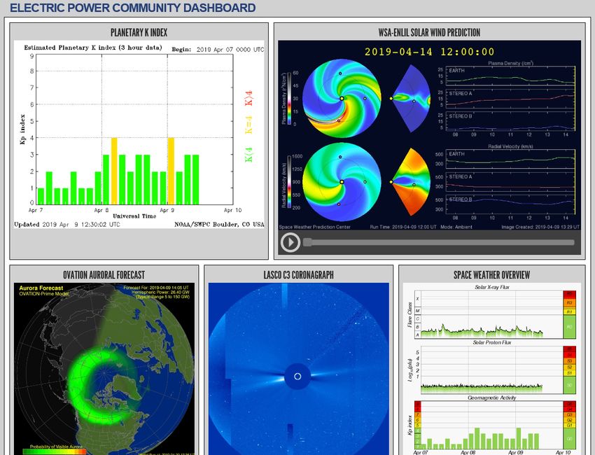
WATCHES, WARNINGS, & ADVISORIES
                              Hazardous Weather Outlook (Today):
           •   Moderate to major river flooding is ongoing at points on the Mississippi and Illinois Rivers.
           •   No severe weather is expected at this time.
                                       Days Two Through Seven:
           •   A few strong to severe storms are possible Wednesday night into early Thursday morning in far
               northwestern Missouri. Damaging hail, wind, and frequent lightning are the greatest concern
               with the strongest storms.
           •   Mixed precipitation may be possible across northern Missouri late Thursday night/Friday
               morning...little to no accumulation is expected.
           •   There is a chance of thunderstorms from Wednesday night through Thursday evening for
               portions of eastern and central Missouri.
           •   Frost and or freeze is possible for portions of northwest, north central, and west central
               Missouri Friday and Saturday mornings as temperatures dip near or to freezing.
           •   Major river flooding will continue at Saverton Lock and Dam on the Mississippi River and at
               Hardin along the Illinois River. Moderate flooding will continue at several other points on the
               Mississippi River.
                           Current Watches, Warnings & Advisories in Effect:
           •   Flood Warning in effect for multiple counties across Missouri.
           •   Dense Fog Advisory for Dunklin and Pemiscot counties.

4/9/2019
4/9/2019
WEATHER STORY
                                                                                                              NWS Kansas City
                                                                                        A few strong, possibly severe, thunderstorms are expected Wednesday night
                                                                                           across portions of Kansas and Nebraska into far northwestern Missouri.
                                                                                       Frequent lightning, damaging winds, and hail to the size of quarters is possible
                                                                                                                 with the strongest storms.

                       NWS Springfield
       Cold temperatures are expected to make a return to much of the Country
      including the Ozarks for the middle of April. This "Encore Visit" will feature
   temperatures from 5 to 10 degrees below normal. With trees, shrubs and flowers
     beginning to bloom, take precautions with tender vegetation. Frosty mornings
                 may be possible this weekend and through April 20th.

4/9/2019
4/9/2019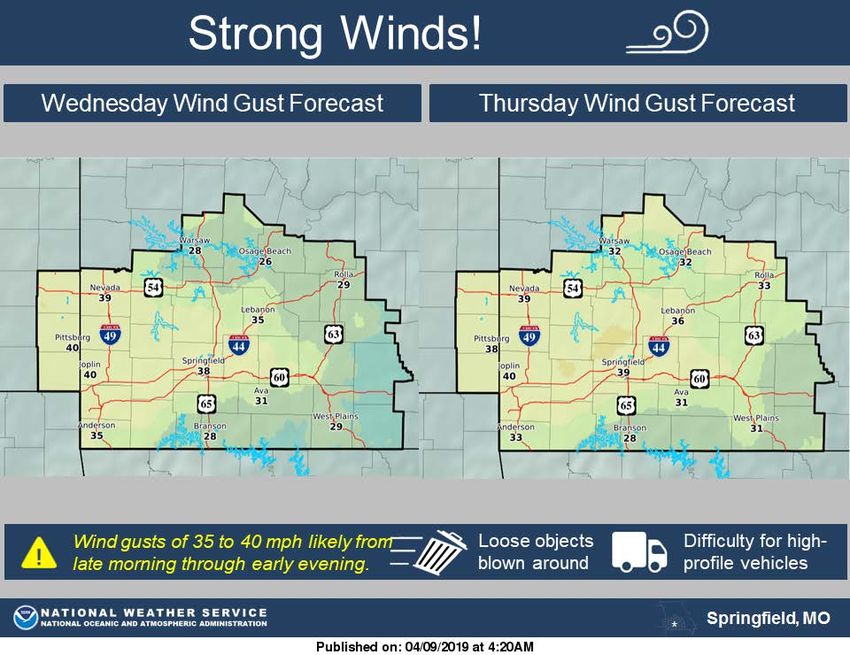
WEATHER STORY
NWS Paducah
Dry and pleasant weather is on tap today and Wednesday. A
strong storm system will bring windy conditions Thursday,
along with a chance of strong thunderstorms. Cooler air will
arrive on Friday behind the cold front.
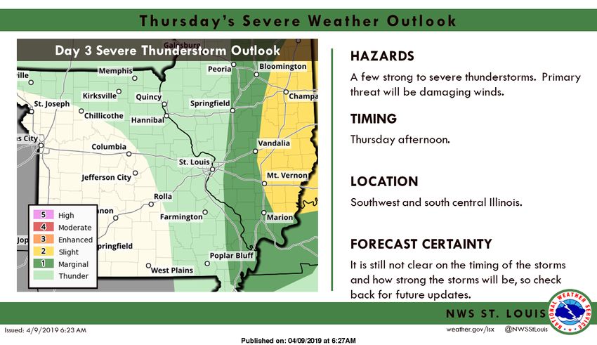
NWS St. Louis
A few strong to severe storms will be possible across south
central and southwest Illinois on Thursday afternoon as a
cold front moves across the area. The primary threat will be
damaging winds.
4/9/2019
4/9/2019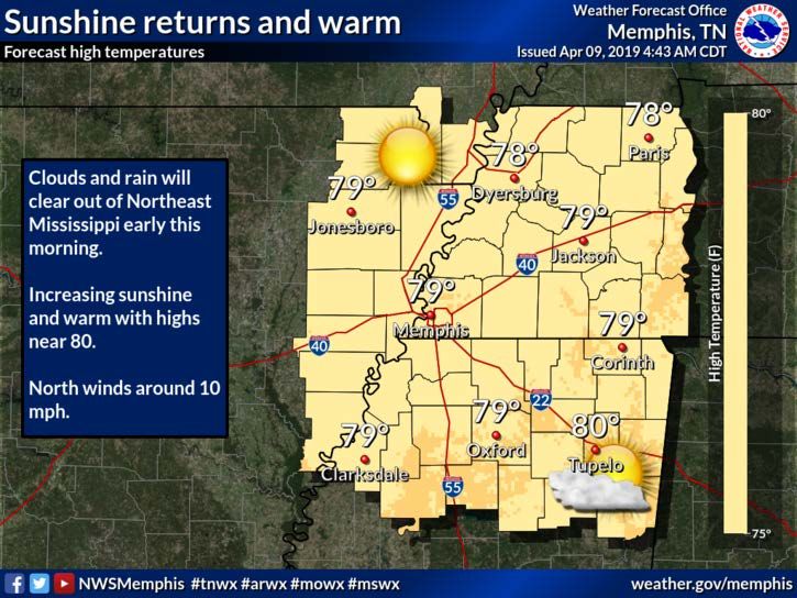
WEATHER STORY
                                                                                           NWS Memphis
                                                                               Increasing sunshine and warm with highs near 80.

               NWS Quad Cities, IA/IL
   Here is the latest on Mississippi River flooding across eastern Iowa and
   northwest Illinois. Visit https://www.weather.gov/dvn/River_Levels for
   additional details. The snowmelt crest is currently near the Quad Cities.

4/9/2019
4/9/2019
SEVERE WEATHER OUTLOOK
                                     Day 2

           Day 1

                                     Day 3

4/9/2019
4/9/2019
PRECIPITATION LAST 24 HOURS

4/9/2019
4/9/2019
PRECIPITATION FORECAST NEXT 72 HOURS
                                             Day 2
                 Day 1

                                             Day 3

4/9/2019
4/9/2019
CURRENT FLOODING: NEAR or ABOVE FLOOD STAGE
Major Flood Stage: Mississippi River
• Keokuk, IA
• Saverton Lock and Dam 22, MO
Major Flood Stage: Other Rivers
• Illinois River at Hardin, IL
Moderate Flood Stage: Mississippi River
• Gregory Landing, MO
• Quincy, IL
• Quincy Lock and Dam 21, IL
• Hannibal, MO
• Louisiana, MO
• Clarksville Lock and Dam 24, MO
• Winfield Lock and Dam 25, MO
• Grafton, IL
• Chester, IL
• Cape Girardeau, MO
• Thebes, IL
Moderate Flood Stage: Other Rivers
• Cuivre River at Old Monroe, MO
4/9/2019
4/9/2019FLOODING FORECAST – 10 DAY
Most Recent Flood Details:
Major Flood Stage Forecast: Mississippi River
• Keokuk, IA
• Saverton Lock and Dam 22, MO
Major Flood Stage forecast: Other
• Illinois River at Hardin, IL
Moderate Flood Stage forecast: Mississippi River
• Gregory Landing, MO
• Canton Lock and Dam 20, MO
• Quincy, IL
• Quincy Lock and Dam 21, IL
• Hannibal, MO
• Louisiana, MO
• Clarksville Lock and Dam 24, MO
• Winfield Lock and Dam 25, MO
• Grafton, IL
• Chester, IL
• Cape Girardeau, MO
• Thebes, IL
Moderate Flood Stage forecast: Other Rivers
• Cuivre River at Old Monroe, MO
• Current warnings can be viewed at:
https://alerts.weather.gov/cap/mo.php?x=1
4/9/2019
4/9/2019FLOODING FORECAST: MISSISSIPPI RIVER – MAJOR FLOOD
STAGE
4/9/2019FLOODING FORECAST: OTHER – MAJOR FLOOD STAGE 4/9/2019
FLOODING FORECAST: MISSISSIPPI RIVER – MODERATE
                       FLOOD STAGE

4/9/2019
FLOODING FORECAST: MISSISSIPPI RIVER – MODERATE
FLOOD STAGE
4/9/2019FLOODING FORECAST: MISSISSIPPI RIVER – MODERATE
FLOOD STAGE
4/9/2019FLOODING FORECAST: MISSISSIPPI RIVER – MODERATE
FLOOD STAGE
4/9/2019FLOODING FORECAST: MISSISSIPPI RIVER – MODERATE
FLOOD STAGE
4/9/2019FLOODING FORECAST: MISSISSIPPI RIVER – MODERATE
FLOOD STAGE
4/9/2019FLOODING FORECAST: OTHER RIVERS – MODERATE
FLOOD STAGE
4/9/2019RECENT EARTHQUAKES
3/9/19 to 4/9/19
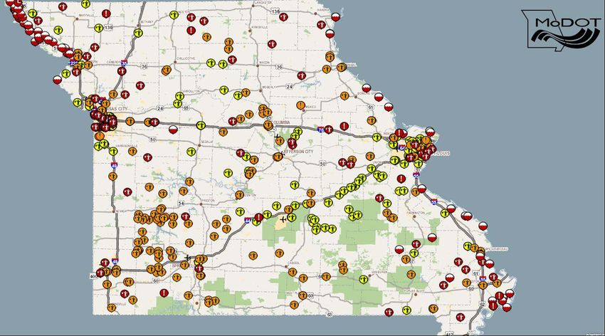
4/9/2019MISSOURI DEPT OF TRANSPORTATION Current Road Conditions 4/9/2019 at 08:37 hours 4/9/2019 4/9/2019
ELECTRIC POWER DASHBOARD

4/9/2019
4/9/2019
ELECTRIC COOPERATIVE OUTAGES
                                          https://outages.amec.org/outages/maps
     System         Outages   System           Outages     System             Outages   System               Outages
    Atchison-Holt             Crawford                     Macon                        Sac Osage
    Barry                     Cuivre River     1           Missouri Rural               Se-Ma-No
    Barton Co                 Farmers                      N Central Mo                 SEMO
    Black River               Gascosage        1           New-Mac                      Southwest
    Boone           9         Grundy                       Osage Valley                 Three Rivers
    Callaway                  Howard                       Ozark              2         Tri County
    Central MO      1         Howell-Oregon                Ozark Border       22        United               1
    Citizens        60        Intercounty      2           Pemiscot-Dunklin             Webster
    Co-Mo                     Laclede                      Platte-Clay        4         West Central
    Consolidated 4            Lewis Co                     Ralls Co                     White River Valley

                                              As of 08:39 hours 4/9/2019

4/9/2019
4/9/2019
ELECTRIC SYSTEM OUTAGES
System Outages Customers
AmerenUE 199 1,243,225
https://outagemap.ameren.com/
0 49,025
City of Columbia
http://outageviewer.gocolumbiamo.com
Empire District 0 170,158
http://www.empiredistrict.com/Outages/OutageMap
KC Power & Light Greater MO 39 638,375
http://outagemap.kcpl.com/external/default.html
City of Springfield 2 113,164
https://www.cityutilities.net/outage/map-status/
As of 08:41 hours 4/9/2019
4/9/2019
4/9/2019CYBER SECURITY 4/9/2019 4/9/2019
Missouri State Emergency Management Agency

                     Statewide Activity Report
                             4/9/2019
                           For Official Use Only

4/9/2019
4/9/2019
DEPT. OF NATURAL RESOURCES EVENTS
Most Recent:
• 4/8/19-Saline Co: Approximate release of 2000 lbs of
ammonia nitrate to ditch.
• 4/3/19-Monett: Spill of 250 gallons material from tote during
transit.
• 4/1/19 – Cape Girardeau Co: release of approximately 1,000
gallons of 32 percent liquid nitrogen fertilizer and less than
50 gallons of diesel fuel released due to commercial motor
vehicle accident.
• 3/31/19 – Lafayette Co: release of approximately 150
gallons of diesel fuel due to commercial motor vehicle
accident.
• 3/31/19 – Cass Co: release of approximately 50 to 100
gallons of diesel fuel released due to equipment
malfunction.
• 3/30/19 – Phelps Co: commercial motor vehicle accident
resulting in release of unknown amount of petroleum.
* Markers shown on map are cumulative for the current month.
4/9/2019
4/9/2019MARCH 2019 INCIDENTS
MISSOURI
STATE EMERGENCY MANAGEMENT
STATE WATCH CENTER Weather Reports Environmental Reports
4/9/2019
4/9/2019Missouri State Emergency Management Agency
Resource Status, Alert Messages,
& Long-Term Outlooks
For Official Use Only
4/9/2019
4/9/2019MISSOURI TASK FORCE 1 (MO-TF1)
URBAN SEARCH & RESCUE
RESOURCE AVAILABILITY
Modular Response Capabilities
• Rescue
TASK FORCE Configuration Status
– Structural Collapse
Type 1 (80 person task force/24 hr. Operational Capability)
– Technical Rescue (Ex: Trench, Rope, Confined Space)
Type 2 (80 person task force/24 hr. Operational
• Wide Area Search Capability,.minus CBRNE element)
• Water Rescue Type 3 (40 person task force/12 hr. Operational Capability)
– Swift Water Type 4 (25 person task force/12 hr. Operational Capability)
– Floods & Moving Water Fully Mission Capable Partially Mission Capable Not Mission Capable
• Canine Search (K-9) • Single or Other Resource also available upon request
Ex: Incident Management Personnel, Plans Section Chief, Ops Section
• Hazardous Material Chief, Logistics Section Chief, etc.
• Command Element
4/9/2019
4/9/2019MO DISASTER MEDICAL ASSISTANCE TEAM 1 (MO DMAT 1)
MO MORTUARY OPERATIONS RESPONSE TEAM 1 (MO MORT 1)
RESOURCE AVAILABILITY
MO Disaster Medical Assistance Team 1
(MO DMAT 1) MO Mortuary Operations Response Team
Medical Response (MO MORT 1)
• Field Hospital – 6 and 24 bed capability
• Medical Strike Teams
• Augment Hospital Staffing Mortuary Response
Logistics Support • Full Disaster Portable Morgue (DPMU)
• Fatality Strike Team for Local Coroner Support
• Medical Supplies
• Victim Identification Center (VIC)
• Setup of DMAT Cache
• Mobile Communications
Command Element
MO DMAT 1 Status
MO MORT 1 Status
Six bed ER 12 person/24 hours/3 days
Type II team 80 members/12 hour
Type II team 35 person/24 hours
Fully Mission Capable Partially Mission Capable Not Mission Capable
Fully Mission Capable Partially Mission Capable Not Mission Capable
4/9/2019
4/9/2019Missouri Department of Health and Senior Services (DHSS)
Reentering A Flooded Home: Health Risks to Avoid – Part 2
A home that’s been flooded can potentially contain a number of health risks that need to be considered
upon re-entry. The Centers for Disease Control and Prevention (CDC) recommends the following:
• Dry out your home to prevent mold.
− If your home has been flooded and has been closed up for several days,
assume it has mold.
− If you have electricity and an electrician has determined that it’s safe to
NWS
turn it on, use a “wet-dry” shop vacuum (or the vacuum function of a carpet
steam cleaner), an electric-powered water transfer pump, or sump pump to
remove standing water. If you are operating equipment in wet areas, be
sure to wear rubber boots.
− If you do not have electricity, or it is not safe to turn it on, you can use a
portable generator to power equipment to remove standing water. Note: If FEMA
you must use a gasoline-powered pump, generator, pressure washer, or any other gasoline-
powered tools to clean your home, never operate the gasoline engine inside a home, basement,
garage, carport, porch, or other enclosed or partially enclosed structures, or less than 20 feet
4/9/2019
4/9/2019Missouri Department of Health and Senior Services (DHSS)
Reentering A Flooded Home: Health Risks to Avoid – Part 2
from any door, window, or vent, even if the windows and doors are open. Such improper use
can create dangerously high levels of carbon monoxide and cause carbon monoxide poisoning.
− If weather permits, open windows and doors of the house to
aid in the drying-out process.
− Use fans and dehumidifiers to remove excess moisture. Fans
should be placed at a window or door to blow the air outwards
NWS
rather than inwards, so not to spread the mold. floodstart.gov
− Have your home heating, ventilating, and air-conditioning (HVAC) system checked and cleaned
by a maintenance or service professional experienced in mold cleanup before you turn it on.
If the HVAC system was flooded with water, turning on the mold-contaminated HVAC will
spread mold throughout the house.
Professional cleaning will kill the mold and prevent later mold growth. When the service
determines that your system is clean and if it is safe to do so, you can turn it on and use it
to help remove excess moisture from your home.
4/9/2019
4/9/2019Missouri Department of Health and Senior Services (DHSS)
Reentering A Flooded Home: Health Risks to Avoid – Part 2
− Prevent water outdoors from reentering your home. For example, rainwater from gutters or the
roof should drain away from the house; the ground around the house should slope away from
the house to keep basements and crawl spaces dry.
− Ensure that crawl spaces in basements have proper drainage to limit water seepage. Ventilate
to allow the area to dry out.
− For more information on mold cleanup, see https://www.cdc.gov/mold/cleanup-guide.html and
https://health.mo.gov/living/environment/floodrecovery/index.php.
Additional guidance on cleaning up safely after a disaster is available from CDC at
https://www.cdc.gov/disasters/cleanup/facts.html.
For more information on flood recovery from the Missouri Department of Health and Senior
Services (DHSS), go to https://health.mo.gov/living/environment/floodrecovery/index.php,
and also to https://health.mo.gov/emergencies/ert/naturaldisasters.php#floods. In addition,
see the 16-page DHSS booklet entitled A Public Health Guide to Safe Disaster Recovery at
https://health.mo.gov/emergencies/ert/pdf/disasterrecoverybook.pdf.
Source: Reentering Your Flooded Home (CDC) (https://www.cdc.gov/disasters/floods/after.html)
4/9/2019
4/9/2019STATE WATCH CENTER
www.sema.dps.mo.gov
@MoSEMA_
MissouriSEMA on Facebook
Email: MOSEMA@sema.dps.mo.gov
Phone: 573-526-9100
Toll-Free: 800-298-6289
4/9/2019
4/9/2019You can also read