MKA Reach, Cambridgeshire - A Biodiversity Assessment to support the Neighbourhood Plan - reach village
←
→
Page content transcription
If your browser does not render page correctly, please read the page content below

Reach – A Biodiversity Assessment for the Neighbourhood Plan
                                                                  March 2021

MKA
ECOLOGY

                        Reach, Cambridgeshire
                  A Biodiversity Assessment
          to support the Neighbourhood Plan
                                                          March 2021

                                                                         0
Reach – A Biodiversity Assessment for the Neighbourhood Plan
                                                                                                                                     March 2021

Site                    Reach

Project number          103520

Client                  Reach Neighbourhood Plan Group

Version
                  Date of issue        Revisions
number

1.0               19 March 2021        Original

Author(s)               Will O’Connor CEcol MCIEEM

                        Will O’Connor CEcol MCIEEM
Surveyor(s)
                        Ellen Miller

                        MKA Ecology Limited
Contact                 01763 262211
                        info@mkaecology.co.uk

            MKA Ecology Ltd is a Chartered Institute of Ecology and Environmental
            Management (CIEEM) Registered Practice.

                                                                                                                                            1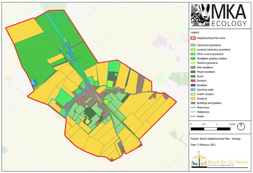
Reach – A Biodiversity Assessment for the Neighbourhood Plan
                                                                                                                                                                                                                                         March 2021

                                                                                                                                                8.2       Appendix 2: UK Habitat Classification Methodology ................................................ 43
CONTENTS
                                                                                                                                                8.3       Appendix 3: Measures for Reach residents to consider for enhancing the biodiversity
                                                                                                                                                in their gardens .................................................................................................................... 44
1         INTRODUCTION ..............................................................................................................3

    1.1       Aims and objectives ....................................................................................................3

    1.2       Site description and context ........................................................................................3

2         LEGISLATION, POLICY AND INITIATIVES ...................................................................6

    2.1       Legislation and policy ..................................................................................................6

    2.2       Local projects and initiatives .......................................................................................8

3         REACH ...........................................................................................................................10

    3.1       The geological setting ...............................................................................................10

    3.2       The ecological setting ................................................................................................10

    3.3       Habitat survey ...........................................................................................................17

4         SENSITIVITIES AND OPPORTUNITIES.......................................................................23

5         SUMMARY              OF      POLICY          PROPOSALS                 AND       OPPORTUNITIES                   FOR        THE
COMMUNITY ...........................................................................................................................34

6         CONCLUSION ...............................................................................................................36

7         REFERENCES ...............................................................................................................38

8         APPENDICES ................................................................................................................39

    8.1       Appendix 1: Legislation and Policy ...........................................................................39

                                                                                                                                                                                                                                                                                   2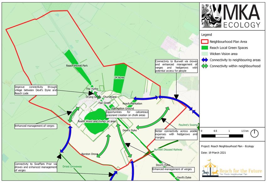
Reach – A Biodiversity Assessment for the Neighbourhood Plan
March 2021
1 INTRODUCTION Reach is situated on a low chalk promontory which extends into the low fenland of
Cambridgeshire, much of which is below sea level. This juxtaposition of high and low ground
creates a fascinating range of geological and ecological influences which ensure that Reach is
1.1 Aims and objectives
rich in biodiversity feature of note. The low fenlands support important populations of birds and
the waterways provide biodiverse corridors with thriving invertebrate communities and notable
In November 2020 MKA Ecology Ltd was commissioned to undertake a biodiversity
aquatic plants. The higher chalklands contain ancient grasslands of national importance, and
assessment of Reach Parish to support the forthcoming Reach Neighbourhood Plan. This
a network of hedgerows that connect developing patches of woodlands. This variety of habitats
reports presents the findings of that assessment which were gathered through a process of
make Reach a biodiverse hotspot with tremendous opportunities for further enhancement.
field studies, consultations and a desktop study. The key aims of the assessment were as
However, consequently this does mean that any potentially damaging activities, such as
follows;
development, must be carefully planned and considered.
Identify and record important habitats within the Neighbourhood Plan Area;
Reach has a strong cultural heritage which is intricately linked with the biodiversity features of
Recommend appropriate measures to protect these habitats, and
the Parish. There is widespread evidence of Roman settlement which is still clear in the
Define initiatives and measures for improving habitats and the ecological network.
landscape with the Reach Lode with was constructed at this time as a navigable connection
between the River Cam and the higher grounds. Where the lode ends in Reach, at a location
The overall aim of the Biodiversity Assessment is to support the Reach Neighbourhood Plan,
known as The Hythe, a port developed with some of the slipways still present and visible today.
the purpose of which will be to help the community shape and influence change in the coming
The Anglo-Saxons created the Devil’s Dyke, a linear earthworks of approximately 11km
years.
running from Wooditton and terminating at The Hythe and lode in Reach. The Devil’s Dyke is
now home to internationally important orchid habitats and a wealth of other chalk specialist
This assessment specifically concerns biodiversity and ecology where areas are identified for
species. Drainage of the fens started in the 17th century which had a dramatic effect on local
opportunities, be they enhancement or development led, there may be other matters which
biodiversity as the fens and swamps were claimed for agriculture. This drainage has continued
make these unsuitable, for example ownership or other identified constraints such as
almost to the present day, the consequence of which is drying and degradation of the peat and
landscape.
a significant lowering of ground levels, to the extent that the lode is up to 3m above the
surrounding peat. Coprolite extraction in the 19th century resulted in the open ponds and pools
1.2 Site description and context that can still be seen in the fen area. Throughout these periods significant quarrying of clunch
took place on Chapel Hill which have created exposed chalk and grasslands which are, over
Reach is situated in East Cambridgeshire District and is approximately 10km north-east of time, succeeding to woodland and scrub.
Cambridge and 7km north-west of Newmarket. The village of Reach is centred on OS Grid
Reference TL566662 but the parish boundary extends significantly to the north-west and south- The fen edge parishes tend to run in strips, from fen, to chalky loam, to sandy boulder clay on
east. The extent is approximately 4.7km². The parish boundary, which is also taken as the higher ground. In more modern times this would ensure that however wet or dry the season
boundary of the Neighbourhood Plan, is shown on Figure 1. The village of Reach has a the parish could count on crops from at least two of these three zones. In earlier times only the
population of approximately 335. central skirt land would have fields laid out around the village and its springs. The higher ground
3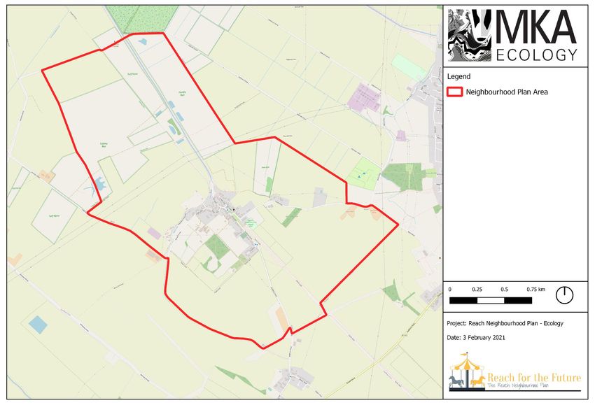
Reach – A Biodiversity Assessment for the Neighbourhood Plan
                                                                                                                                                                                          March 2021

would have been forest providing wood and panage for pigs. The lower ground would have                    Since the mid-20th century development within Reach has been small scale, and typically infill,
been fen, providing marshy grazing in summer but in winter the waters may have risen                      replacement dwellings or conversions. The 2015 Local Plan proposes only infill for Reach with
considerably with no drainage. The fen would have also provided fish and wildflowl as well as             no new allocations within the Strategic Land Availability Assessment (SLAA, 2014).
other materials such as reed for thatching, and willows for wattles, fishtraps and baskets. Each          Opportunities for commercial or industrial development are limited although there is potential
of the three zones would have been vital for the local community (Ennion, 1949).                          for further solar applications beyond the community solar farm. There is some limited
                                                                                                          accommodation for small business. With the rich natural environment and features of historical
In January 2019 it was agreed that Reach would develop its own Neighbourhood Plan. The                    interest in the locality there is potential for tourism led development.
plan will help the community shape and influence planning strategy in the neighbourhood. It
will encompass a suite of topics including development, recreation, traffic management,
landscape, as well as biodiversity and nature conservation. The Neighbourhood Plan will have
the same legal force as the East Cambridgeshire District Council Local Plan and will carry
statutory weight. East Cambridgeshire District Council will need to consider the Neighbourhood
Plan when determining planning applications.

A landscape appraisal has been produced by Alison Farmer to support the Neighbourhood
Plan (AFA, 2020). Where relevant the landscape appraisal report is referred to within this
assessment. AECOM (2020) have also produced a design code for potential development.

As part of the Neighbourhood Planning process a residents’ survey was conducted in early
2020. The survey demonstrated that the natural features of the parish are of significant value
to the community. High quality greenspaces, good access and footpaths, abundant and varied
wildlife, proximity to wild places and areas of little light pollution were all highlighted as features
which make Reach an attractive place to live. The survey also raised concerns about the
environmental impacts of further housing. A small amount of new housing was thought
necessary but the great majority of villagers responding to the questionnaire were keen to
ensure that any such development protected and enhanced local wildlife and habitats. Finally
it was clear that the community would like to see some level of protection for greenspace that
does not currently receive any protection. These areas included The Hythe, Reach Lode, the
fen-edge, the woodlands, hedges, footpaths, bridleways and droveways, and finally the
geological features of interest. The results reveal that the residents of Reach place a high value
on their biodiversity, and are keen to both protect and enhance it.

                                                                                                                                                                                                     4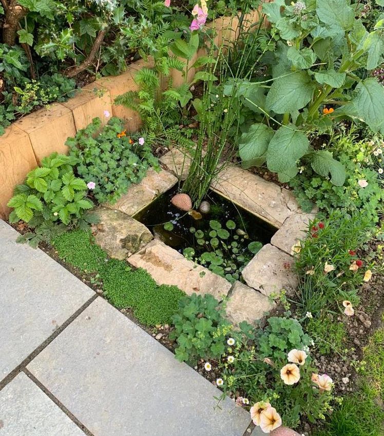
Reach – A Biodiversity Assessment for the Neighbourhood Plan
                                                                                                                            March 2021

Figure 1: Map showing the Neighbourhood Plan (and Reach Parish) boundary

                                                                                                                                   5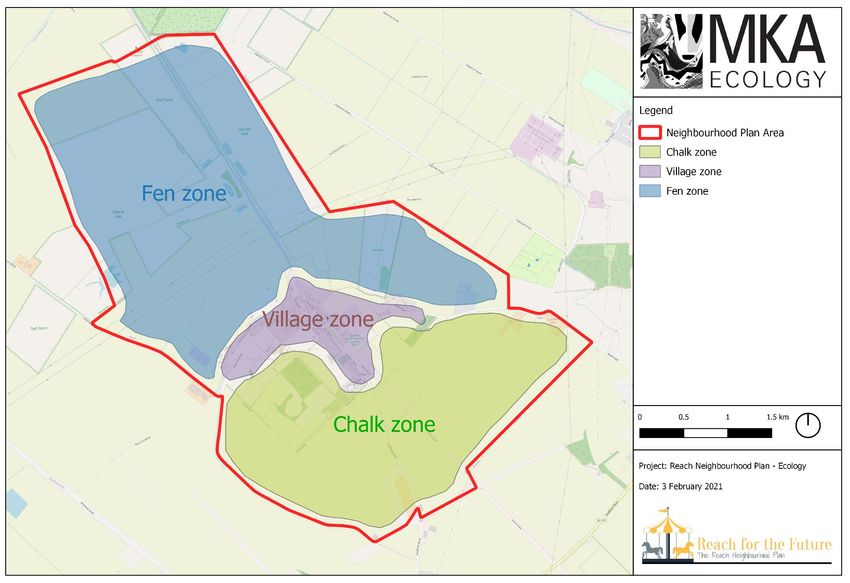
Reach – A Biodiversity Assessment for the Neighbourhood Plan
March 2021
2 LEGISLATION, POLICY AND ‘All development proposals will be required to:
INITIATIVES Protect the biodiversity and geological value of land and buildings and minimise harm
to or loss of environmental features, such as trees, hedgerows, woodland, wetland
and ponds.
2.1 Legislation and policy
Provide appropriate mitigation measures, reinstatement or replacement of features
and/or compensatory work that will enhance or recreate habitats on or off site where
National legislation and planning policy
harm to environmental features and habitat is unavoidable; and
Maximise opportunities for creation, restoration, enhancement and connection of
This assessment has been made with reference to relevant wildlife legislation and planning
natural habitats as an integral part of development proposals.
policy. Relevant legislation considered within the scope of this document includes the following:
Development proposals where the main aim is to conserve biodiversity will be permitted; and
The Wildlife and Countryside Act 1981 (as amended);
opportunities to incorporate biodiversity into new development will be supported.
The Conservation of Habitats and Species (Amendment) (EU Exit) Regulations
2019; All applications for development that may affect biodiversity and geology interests must be
Natural Environment and Rural Communities Act 2006; accompanied by sufficient information to be determined by the Local Planning Authority,
The Countryside and Rights of Way Act 2000; including an ecological report, to allow potential impacts and possible mitigation measures to
Wild Mammals (Protection) Act 1996. be assessed fully. Where there is reason to suspect the presence of protected species, trees
and woodland, applications must be accompanied by a survey carried out by a qualified
In addition to obligations under wildlife legislation, the revised National Planning Policy individual assessing their presence and, if present, the proposal must be sensitive to, and make
Framework (NPPF) updated on 19 February 2019 requires planning decisions to contribute to provision for, their needs, in accordance with the relevant protecting legislation. Where
conserving and enhancing the local environment. Further details on this legislation and policy appropriate, there will be a requirement for the effective management of designated sites and
is provided in Appendix 1. Where relevant they are referred to in the text. other features, controlled through the imposition of conditions or Section 106 agreements.
Local planning policy Proposals which have an adverse impact on a site of international importance will
not normally be permitted unless there are exceptional overriding reasons of public
East Cambridgeshire District Council has withdrawn the 2019 local plan and therefore the interest (human health, public safety or environmental benefit).
adopted 2015 Local Plan is referred to this in this assessment (East Cambridgeshire District Proposals which have an adverse impact on a site of national importance will not
Council, 2015). With regard to biodiversity the Strategic Land Availability Assessment (SLAA, normally be permitted unless the benefits of the development at the site significantly
2014) does not contain any sites within Reach. outweigh the impacts.
Policy ENV 7 relates specifically to biodiversity and geology and is as follows.
6
Reach – A Biodiversity Assessment for the Neighbourhood Plan
March 2021
Proposals which would cause harm to County Wildlife Sites, Ancient Woodland, aged and as wildlife rich habitat, or create off-site contributions to the vision via provision of
veteran trees, Local Nature Reserves, Protected Roadside Verges, and any other irreplaceable habitat or financial contributions.
habitats, and green corridors or important species will not be permitted unless the need for, Policy SPD.NE8: Trees and Woodland. Existing tree and woodland cover should be
and benefits of development in that location outweigh the potential harm to nature conservation maintained, improved and expanded and opportunities for expanding woodland
interests.’ should be actively considered and implemented where practicable to do so.
Guidance on the number of compensatory trees is provided.
East Cambridgeshire District Council have recently produced a Supplementary Planning Policy SPD.NE9: Landscaping and Biodiversity. New planting should be integral to
Document (SPD) for biodiversity (East Cambridgeshire District Council, 2020). This establishes design providing corridors, native species and sufficient appropriate habitats for
the following policies; biodiversity.
Policy SPD.NE10: Taking the most appropriate natural environment opportunities.
Policy SPD.NE1: Conserving and Enhancing Biodiversity – Internationally Provision of new natural environment infrastructure must be appropriate and the
Designated Sites. Strengthened protection for internationally designated sites. make the most of site specific opportunities.
Policy SPD.NE2: Proposals within the Swan ad Goose Impact Risk Zone. Greenfield Policy SPD.NE11: Provision of sufficient, suitable and robust information.
major development within the IRZ must undertake a project-level Habitat Regulation Development proposals must be accompanied by sufficient, suitable and robust
Assessment. information to enable the effects on biodiversity to be assessed.
Policy SPD.NE3: Development resulting in the loss of deterioration of a County
Wildlife Site (CWS), Local Nature Reserve (LNR) or Protected Roadside Verge Neighbourhood planning policy
(PRV). Development resulting in the loss of CWS, LNR or PRV which are
irreplaceable habitats will be refused unless there are wholly exceptional reasons Neighbourhood planning was introduced in the Localism Act (2011) and is a tool which gives
and suitable compensation strategies. communities statutory powers to shape the way their communities develop. The
Policy SPD.NE4: Soham Commons. The wildlife, landscape and recreational quality Neighbourhood Plan is;
of the Soham Commons should be protected and enhanced.
Policy SPD.NE5: Reviewing planning applications for Protected Species. A document that sets out planning policies for the neighbourhood area which are
Appropriate survey effort should be conducted and it should be feasible to acquire used whether to approve planning applications;
correct licences, and to ensure appropriate mitigation, compensation and monitoring. Written by the local community rather than the Local Planning Authority; and
Policy SPD.NE6: Biodiversity Net Gain. In the absence of a nationally mandated A powerful tool to ensure the community gets the right types of development in the
mechanism to secure biodiversity net gains (forthcoming in the Environment Bill) right place.
proposals must significantly exceed pre-development values (demonstrated with the
Defra metric) or be refused. Neighbourhood Plans should be prepared positively in a way that is aspirational and
Policy SPD.NE7: Contributing to the strategic target of doubling land for nature. deliverable. Neighbourhood Plans can contain policies on the contributions expected from
Strategic scale development proposal could contribute to the Local Nature development, but these and other requirements placed on development should accord with the
Partnership’s ‘doubling land for nature’ vision by providing 20% of the application site relevant strategic policies and national planning policy.
7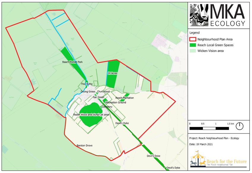
Reach – A Biodiversity Assessment for the Neighbourhood Plan
March 2021
Wicken Fen Vision
NPPF (2019) Section 8 (paragraph 100) allows local communities to identify green areas for A 100 year plan, driven by the National Trust, to create a diverse landscape for people and
special protection within Neighbourhood Plans. These Local Green Spaces (LGS) must provide wildlife, stretching from the existing Wicken Fen reserve to the edge of Cambridge in the south.
special benefits to the community and the criteria in the NPPF paragraph 100 are as follows; Wicken Fen vision land covers more than half of the Reach Neighbourhood Plan Area and is
consequently likely to have a significant impact on the biodiversity of Reach in the coming
In reasonably close proximity to the community it serves; years. The area covered by the Wicken Vision are shown in Figure 2.
Demonstrably special to the local community and holds a particular local
significance, for example because of its beauty, historic significance, recreational Fen Biosphere
value (including as a playing field), tranquillity or richness of its wildlife; and A project to create a UNESCO biosphere across the fenland landscape, becoming the first of
Local in character and is not an extensive tract of land. such area in East Anglia. The key threads linking activities within a biosphere are 1) Biospheres
will meet the needs of their current and future residents and work towards providing secure and
2.2 Local projects and initiatives happy futures for all, 2) Biospheres will improve the natural environment, and 3) Biospheres
will use new ideas, science and technology to explore new ways of living everyday that solve
global challenges. Reach is located within the buffer zone of the proposed biosphere.
Natural Cambridgeshire (Local Nature Partnership)
A partnership of local authorities, wildlife and countryside charities, non-departmental
Buglife B-lines
government bodies and developers. Creating an action plan for the Cambridgeshire natural
A project to provide connectivity for invertebrates across the UK by linking existing habitats
environment through key themes and projects. This includes living landscapes which aims for
with new areas of habitat creation (Buglife, 2021). Reach lies directly within a key B-line linking
landscape scale restoration. A key project is Doubling Nature with the aim of doubling the
the chalk to the fens.
amount of land that is managed for nature conservation from 8% to 16% which is the national
average. Other themes include local food and farming, sustainable jobs and healthy
Figure 3: Buglife B-lines over Reach
communities.
Cambridgeshire Green Infrastructure Strategy Wicken Fen
The Cambridgeshire Green Infrastructure Strategy (Cambridgeshire County Council, 2011) is
designed to assist in shaping and coordinating the delivery of green infrastructure in the county
Reach
with the aim of 1) reversing the decline in biodiversity, 2) mitigate and adapt to climate change,
3) promote sustainable growth and economic development, and 4) support healthy living and
well-being. Reach lies within the Wicken Fen and Anglesey Abbey target area with objective to
open up areas for wildlife and people, create habitats particularly for fenland species, protecting Newmarket
resources such as water and peat, provide opportunities for residents and visitors to access
nature, and provide economic opportunities.
8
Reach – A Biodiversity Assessment for the Neighbourhood Plan
                                                                                                                 March 2021

Figure 2: Showing the Wicken Vision area in relation to Reach

                                                                                                                        9
Reach – A Biodiversity Assessment for the Neighbourhood Plan
March 2021
habitat might be appropriate for biodiversity interventions in the area, and what habitats should
3 REACH be protected. Table 1 provides a summary of the sites and they are shown on Figure 4.
These areas include Sites of Special Scientific Interest (SSSI) and National Nature Reserves
3.1 The geological setting
(NNR) which are designated at a national level and Special Areas of Conservation (SAC) which
were designated at an international level within the European Union. Following the UK’s
The village of Reach lies on the West Melbury Marly Chalk Formation reaching to around 15m
withdrawal from the EU they are now recognised as part of a new ‘national site network’ but it
above sea level. The lower grounds of the fens to the north and west, at sea level or below,
would be appropriate to continue to consider them of international importance. One of these
comprise peat over Gault Formation clay. Where the intersections of gault and chalk meet
areas, the Devil’s Dyke, is situated within the Reach Neighbourhood Plan Area.
springs rise around the village skirt lands.
Table 1: Statutory designated sites within 5km of Reach Neighbourhood Plan Area
3.2 The ecological setting
Site Direction Reasons for citation
and
National Character Areas distance
Wicken Fen 1.3km north The best surviving remnant of East Anglian Fen in the
Reach straddles two national character areas which are 46 The Fens and 87 East Anglian
NNR, Ramsar, context of Cambridgeshire with a diverse flora and fauna
Chalk. The intersection of the two is formed by the fen edge habitats just to the west of Reach.
SSSI, SAC (notably the invertebrate fauna and relic fenland flora).
(Fenland) To the north of Wicken Lode is original peat fen with
46 The Fens: Characterised as an expansive low-lying wetland landscape. Woodland cover is
communities of carr and sedge. To the south of the lode
sparse and the open fields are bounded by drains and river systems which provide an important
are open rough pasture, reedbeds and pools.
ecological network. An important area for biodiversity with several internationally recognised
The assorted waterbodies contain many aquatic plants
areas of nature conservation value.
including rarer species such as greater spearwort
Ranunculus flammula and lesser water-plantain Baldellia
87 East Anglian Chalk: Characterised by smooth rolling chalkland hills with large irregular
ranunculoides.
field enclosed by low-lying hedgerows. Much of the area is under cereal production but
The Fenland SAC is designated for the presence of
important semi-natural habitats include lowland calcareous grassland and the chalk streams
several important habitat types including Molinia
which are under significant threat from modification and abstraction.
meadows and calcareous fens. These sites also support
important species included the spined loach Cobitis
Statutory designated site of nature conservation interest
taenia and great crested newt Triturus cristatus.
Cam Washes 2.4km north- Low-lying pastures subject to seasonal flooding which
Reach is connected to a number of statutory sites of nature conservation interest, some of
SSSI west are important for breeding and wintering birds. In
which are of international importance. These sites provide an insight into the habitat and
species which are of significance in this setting. They also allow us to consider what target
10Reach – A Biodiversity Assessment for the Neighbourhood Plan
March 2021
Site Direction Reasons for citation Non-statutory sites of nature conservation interest
and
distance A number of non-statutory sites also fall within close proximity of the Neighbourhood Plan Area,
additional the agriculturally unimproved areas of the although none are in the parish itself. These are described in Table 2 and include County
pasture hold important botanical communities. Wildlife Sites (CWS). They are shown on Figure 4.
Upware Bridge 5km north Cited for its geological interest with a particularly rich
Pit North SSSI ammonite fauna. Table 2: Non-statutory sites within close proximity of Reach Neighbourhood Plan Area
Upware South 3.5km north Cited for its geological interest showing a section through Site Direction Reasons for citation
Pit SSSI the Oxfordian ‘Upware reef’. and
Stow-com- 5km south- Contains areas of floristically rich calcareous loam distance
Quy Fen SSSI west pasture and a number of pools formed on Chalk Marl Burwell Adjacent to The banks of this disused railway support extensive
which contain rare aquatic species. Disused south-east areas of unimproved calcareous grassland with many
Devil’s Dyke SSSI within Holds one of the best and most extensive areas of Railway CWS boundary strong indicators of this habitat type. Kidney vetch
SSSI, SAC Reach, SAC species-rich chalk grassland in the county with good Anthyllis vulneraria and horseshoe vetch Hippocrepis
section areas of chalk scrub grading to woodland in the east. comosa are abundant and provide larval food plants for
3.5km south- These are habitats which are severely restricted in their small blue Cupido minimus and chalk-hill blue
east UK range. Supports a number of rare species including Polyommatus coridon butterflies respectively. This site is
bastard toadflax Thesium humifusum and pasque flower contains the few remaining colonies of these species in
Pulsatilla vulgaris. This botanical and structural diversity Cambridgeshire. Spanish catchfly Silene otites, a
supports important populations of invertebrates. nationally rare plant, is also present.
Devil’s Dyke is listed as an SAC because of the dry Driest 250m south- A dry droveway with species-rich grassland bound by
grassland on calcareous substrate which has important Droveway west lines of trees and hedgerows. The grassland contains a
orchid sites (particularly lizard orchid Himantoglossum CWS number of strong calcareous and neutral grassland
hirinum). indicators.
Newmarket 3.5km south- The largest expanse of unimproved chalk grassland in Swaffham 350m south A wet meadow (previously more so) with areas of marshy
Heath SSSI east Cambridgeshire, and particularly notable for areas of Prior grassland and swamp. The grasslands contain a number
chalk heath which is very rare in the UK and comprises Meadows of neutral indicator species and the hedgerows around
an intimate complex of both acidic and chalk loving CWS the perimeter are of value for biodiversity.
species. As well as scarce botanical species an Pauline’s 250m south- A meadow with areas of marshy grassland and swamp.
important invertebrate assemblage is also present. Swamp CWS east Several ponds and hedgerows also offer biodiversity
value.
11Reach – A Biodiversity Assessment for the Neighbourhood Plan
March 2021
Site Direction Reasons for citation located on the fringes of the village at Reach Wood, the 24 Acres and the Plantation. Small
and areas are also present in the Wicken Vision area in the form of woods fringing ponds and fishing
distance lakes.
Spring Close 350m east An area of slightly calcareous grassland on the
CWS earthworks of Burwell Castle, particularly on the steeper Within the Reach Neighbourhood Plan Area are a number of open greenspaces with nature
embankments which are not mown as regularly. Areas of conservation value that are not designated. These have been established as part of local
spring-fed marsh are also present. initiatives, or are pre-existing greenspaces in the village. They are summarised as follows;
Burwell Brick 2km north- Disused brick pit with a mosaic of habitats including a
Pit CWS east lake fringed with swamp habitats. There are also areas Reach wood: An area of woodland (4.59ha) which was planted on arable land by the village
of calcareous grassland and scrub. in 1994. It comprises plantation woodland with rides and a large expanse of meadow which
had been seeded with a calcareous grassland mix. Reach Wood is managed by The Woodland
Undesignated green spaces Trust and a management plan has been produced (The Woodland Trust, 2012). Dominated by
beech Fagus sylvatica it also contains ash Fraxinus excelsior, cherry Prunus sp., field maple
Within 2km are several areas identified by Natural England Priority Habitats Inventory. These Acer campestre, crab apple Malus sylvestris and yew Taxus baccata with a shrub layer of hazel
priority habitats are listed as important on Section 41 of the Natural Environment and Rural Corylus avellana, dog rose Rosa canina, wayfaring tree Viburnum lantana and spindle
Communities Act (2006) and here they include: Euonymus europaeus. The wood is known to support bee orchid Ophrys apifera and common
spotted orchid Dactylorhiza fuchsii. The management plan has undergone changes to
Floodplain grazing marsh: Particularly in areas around Wicken Fen and the Wicken Vision accommodate concerns regarding the impact of mowing on site fauna. However, the solution
areas. Some of these habitat parcels lie within the Neighbourhood Plan Area. of cutting the grass at a higher level is likely to result in a deterioration of grassland quality over
time.
Lowland calcareous grassland: Along the Devil’s Dyke running right into the Neighbourhood
Plan Area and Reach village. Reach plantation: Part of the County Farms Estate this wood was planted as a joint venture
with the Forestry Commission in 1998. Species include beech, field maple and hazel. A
Lowland fens: This habitat occurs at Wicken Fen to the north of the Neighbourhood Plan Area. woodland ride runs through the centre of the wood which provides public access via this
Small areas are also present close to Burwell and Swaffham Prior. permissive bridleway.
Traditional orchards: Occurring within the Neighbourhood Plan Area on the fringes of the Reach Pocket Park: Situated alongside Reach Lode this park comprises grassland, ponds
village at 24 Acres and on the fen edge. Scattered throughout the wider area but typically and concomitant hedgerows. The grassland is thought to be unimproved and potentially of
associated with the villages. significant value. The areas is managed traditionally with grazing through the winter. A pond
with planted willows is situated to the north which is likely an old coprolite pit.
Deciduous woodland: Scattered throughout the Neighbourhood Plan Area and the
surrounding landscape. More common on the higher ground but still sparse. Much of this is 24 Acres: An area of public access delivered as part of the Wicken Vision. Owned by the
National Trust a range of features are being developed including woodland, a traditional
12Reach – A Biodiversity Assessment for the Neighbourhood Plan
March 2021
orchard, a cricket pitch, a manege and areas of grassland. The orchard has a range of varieties, Drying Green: An area of open space with silver birch and cherry trees situated in the heart
many local, including apples, pears, cherry and mulberry. The woodland is just over 2ha in of Reach village. Thought to have some archaeological significance.
extent and was planted as a natural woodland in 2013. A total of 25 tree and shrub species
were planted. Oak, beech and lime will be the dominant species. This wood will evolve into a Recreation ground: An amenity area with open grassland for sports, and other play and sports
significantly different habitat to Reach Wood by virtue of the planting mix and the underlying facilities. This is situated directly adjacent to the Devil’s Dyke. A number of mature elms Ulmus
soils and hydrology. sp. are present in this location which are of ecological value.
The Hythe: The Hythe forms a promontory stretching into the fen from Reach Village. It forms Cemetery: A small cemetery is present in the heart of the village just off Fair Green. The
a connection in the linear route that leads from the Devil’s Dyke through Fair Green and then cemetery comprises grassland which is currently of unknown ecological value. Rows of lime
along the Reach Lode through the fen. It is dominated by the now largely defunct sewage Tillia sp. provide further habitat features.
treatment works but contains areas of scrub, grassland and mature trees. Artificial channels
run either side which join the load. It is believed to have significant cultural and archaeological Wicken Vision: Wicken Vision significantly shapes how the landscape around and within the
interest as it would have formed the centre of the mediaeval port. It is not a natural feature but Neighbourhood Plan Area is formed, and will likely be one of the most significant influences on
entirely manmade with chalk rammed down onto the peat. the area in the years to come. The vision is to create a diverse landscape for people and wildlife
which will cover 53km² and reach all the way from the original fen reserve to the edge of
Fair Green: A linear village green that runs through Reach which is largely dominated by Cambridge.
amenity grassland. This would have been on the original course of the Devil’s Dyke but this
was levelled in the 1700s, with the chalk used to create The Hythe. The vision offers an opportunity for landscape restoration that will allow natural processes to
take their course with careful interventions through grazing and water management. The target
will be a mosaic of wildlife rich habitats which incorporate access for people to enjoy. The
measures will also ensure that the peat, and its carbon storage potential, is conserved. These
aims will be achieved through land purchase and collaboration. Some areas of land around
Reach have already been purchased and rewilding is currently underway.
Barston Drove: This is a public right of way along the southern perimeter of the neighbourhood
plan area. It comprises rough grassland and hedgerows. The quality of the grassland habitats
is unknown and area of higher quality grassland could be present depending on the extent of
agricultural influences from the neighbouring farmland, and the use by the track of off-road
vehicles. There is also scrub encroachment from the adjacent hedgerows with suckering
blackthorn which is likely to further reduce the condition of any grassland habitats over time.
Barston Drove does provide an important wildlife corridor, particularly when taking into account
Fair Green, sketch by Eric Ennion
its connectivity to the Catchwater Drain. Furthermore the droveway provides a corridor for
wildlife through an area which is otherwise dominated by intensive farming activities.
13Reach – A Biodiversity Assessment for the Neighbourhood Plan
March 2021
aquatic species in the lode, such as the stonewort Nitella tenuissima which only grows in this
Church of St Ethelreda and the Holy Trinity Churchyard: A small area of grassland and one location in England.
ornamental planting around the church off Fair Green. To the rear of the churchyard stands the
remaining east wall and window of the chancel of the former chapel that stood at this location.
Notable species within the wider area
Natural England have identified some of the habitats in the Neighbourhood Plan Area, and the
surrounding countryside, as suitable for target bird species within countryside stewardship
scheme. The target bird species which have been identified are;
Corn bunting Emberiza clanadra;
Lapwing Vanellus vanellus;
Redshank Tringa totanus; and
Snipe Gallinago gallinago.
RSPB’s Bird Conservation Targeting Project also identified habitats in this location for a number
of farmland bird targets including;
Corn bunting;
Lapwing;
Redshank;
Snipe;
Grey partridge Perdix perdix;
Tree sparrow Passer montanus;
Turtle dove Streptopelia turtur; and
Yellow wagtail Motacilla flava.
Wicken Fen is a Plantlife Important Plant Area (Plantlife, 2021). These are locations which have
been identified as botanically the most important areas in the UK. Wicken is noted for the
species growing on the peat, such as Cambridge milk parsley Selinum carvifolia and also the
14Reach – A Biodiversity Assessment for the Neighbourhood Plan
March 2021
Figure 3: Statutory and non-statutory designated sites around Reach
15Reach – A Biodiversity Assessment for the Neighbourhood Plan
March 2021
Figure 4: Open greenspaces within Reach Neighbourhood Plan Area
16Reach – A Biodiversity Assessment for the Neighbourhood Plan
March 2021
Summary of the key ecological features present around Reach potential to occur in these habitats is provided. These assumptions are guided by species
records provided by Cambridge and Peterborough Environmental Records Centre (CPERC).
The habitats and species listed above go some way to demonstrate the diversity that is present
in this landscape, largely driven by the contrasting geological conditions in the higher and lower Within the UK the Natural Environment and Rural Communities Act (2006) lists species and
ground. Key ecological features around Reach are; habitats which are of value. These are defined as Species and Habitats of Principal Importance.
Where relevant Habitats of Principal Importance are identified in the sections below.
Fenlands: Important for the aquatic habitats that they support, particularly grazing marsh,
swamps, open water and lodes. Species of note include a huge number of plant species Grasslands
associated with these habitat types, but also breeding and wintering bird assemblages,
invertebrates and fish such as spined loach. Mammals will also utilise these habitats with Calcareous grassland (g2). This habitat type occurs south and east of the village within the
notable species including otter Lutra lutra, water vole Arvicola amphibius and numerous bat paddocks and pastures on higher ground. This grassland is not necessarily species rich but it
species. lies over the chalky soils that are present in these locations. Some are degraded through
intense grazing or alteration.
Calcareous grasslands: The areas surrounding Reach, and within the parish, contain some
of the most important calcareous grassland habitats in the UK. This habitat comprises species- Lowland calcareous grassland (g2a). This valuable habitat type occurs along the Devil’s
rich grassland with a number of rarities recorded in the locality, such as Spanish catchfly. Dyke and adjacent areas along its length. Further areas of calcareous grassland are present
in Reach Wood and are also likely to be present in neighbouring pasture where there appears
These are by no means the only ecologically valuable habitats which are present, within this to be less intensive grazing. Lowland calcareous grassland is a Habitat of Principal Importance.
network are situated other features of high biodiversity value such as the traditional orchards
on the fringes of the villages and the scattered woodlands and hedgerows on the higher ground. Other neutral grassland (g3c). This habitat type is present through the north of the survey
These features all combine to create a network of biodiversity across the area. area and is dominated by the grazing marshes across the Wicken Vision area. This grazing
marsh grassland can be further classified as Holcus-Juncus neutral grassland (g3c8) which is
3.3 Habitat survey typical of poorly drained permanent pastures on lowlands with rough grasslands and rushes.
Lowland floodplain grazing marsh is a Habitat of Principal Importance. The broader category
The Reach Neighbourhood Plan Area was surveyed using the UK Habitat Classification and of other neutral grassland has been applied for grazing on the lower ground which remains
Mapping methodology (UK Habitat Classification Working Group, 2018) through winter 2020 – drier, such as the horse grazing close to The Hythe.
2021 over several visits. The habitats recorded were assigned a pre-defined category
according to this methodology. A full description of this methodology is provided in Appendix Modified grassland (g4). This habitat type falls into two categories. The first is the clearly
2. The Reach Habitat Map is shown in Figure 6. modified amenity grasslands that are present at Fair Green or the recreation ground. Secondly
the intensively grazed pastures in the southern part of the survey area were included in this
Due to time and seasonal constraints it was not possible to collect a full inventory of species in habitat type. These areas appeared to have a very low floristic diversity and some, such as the
the Neighbourhood Plan Area. However, in the sections below an indication of the species with horse paddocks on Chapel Hill have been reseeded with a grass mix. The sheep grazing to
the south of the Devil’s Dyke has been placed in this category although this area should be
17Reach – A Biodiversity Assessment for the Neighbourhood Plan
March 2021
treated with caution. Due to the time of year it was not possible to accurately identify the quality The combination of a linear feature with good connectivity and suitable, well-established
of the habitat type and there is some risk that it could contain calcareous species of interest habitats means that the Devil’s Dyke is highly likely to support populations of reptiles. There
and would therefore be reclassified as lowland calcareous grassland. are records of common lizard Zootoca vivpara through the area. This species may also be
present on the grazing marsh habitat within the rough grassland that is present there. There is
Traditional orchards. These are included within the grassland type for this methodology. They a good population of common lizard at Wicken Fen which may aid colonisation of the grazing
comprise fruit trees over modified grassland at Reach and occur at two locations. The main marsh as they succeeded from arable. The mosaic of wetland habitats right up to the edge of
area of habitat is located at 24 Acres where the orchard was planted in 2013. Traditional Reach Village offer good opportunities for grass snake Natrix helvetica also.
orchards are a Habitat of Principal Importance.
The old calcareous grasslands are of great significance for plants and fungi with a number of
rare species recorded in this habitat type, such as Spanish Catchfly. There are several records
along the Devil’s Dyke, close to the survey area, of lizard orchid Himantoglossum hiricinum
which is an exceptionally scarce species. The botanical diversity of this habitat type also gives
rise to important assemblages of invertebrates, particularly butterflies with small and chalk-hill
blue butterflies recorded in the area.
The Devil’s Dyke has clearly been identifiable as a feature of botanical interest for some time.
It was visited by John Ray (1627-1704). In his flora of 1660 he records ‘mouse-eare with a
large white flower… upon the hill of the heath, on Newmarket heath among the bushes, and in
the devills ditch plentifully’, ‘bloody cranes-bill… found on the Newmarket heath and in the
Devil’s Ditch’ and ‘flie orchies… On the banks of the Devils ditch’. These being field chickweed,
blood crane’s-bill and fly orchid (Ewen and Prime, Trans. and Eds., 1975). Ennion (1949)
describes the chalk grassland on the Devil’s Dyke at Reach in 1948 as such; ‘The grey-green
groundwork of the leaves and grasses, enlivened by a myriad points of colour has a quality of
Jacobian needle-work. Purple of knapweed and bellflower, pink sainfoin, blue of scabious and
harebell, lemon rockrose, golden lady’s fingers, white of meadowrue and milfoil…’. Whilst some
of this diversity is still apparent it appears likely there has been a decline, with scrubbing up of Grass snake
the feature.
The grazing marshes provide significant opportunities for birds all year around. The wet
Recent studies have suggested that where conditions are appropriate there is some evidence grasslands provide breeding habitat for a range of notable species such as redshank and
that key botanical species have moved from the Devil’s Dyke and colonised the adjacent yellow wagtail. The combination of habitats provide opportunities for cuckoo in spring as it
habitats (Leslie, 2020). This provides promise for habitat restoration on the dyke, and also for parasitizes the nests of reed warbler Acrocephalus scirpaceus and meadow pipits Anthus
habitat creation projects within adjacent areas.
18Reach – A Biodiversity Assessment for the Neighbourhood Plan
March 2021
pratensis. In winter these areas would provide foraging grounds for species such as snipe and Whilst the date of their planting is unclear it is likely to have been in the 1990s. A wide variety
owls including barn owl Tyto alba and short-eared owl Asio flammeus. The grasslands on the of woodland are categorised as Habitats of Principal Importance however due to these young
chalk habitats, in combination with arable crops, will provide important habitat for farmland birds age of these woodland types they have not been classified as such here.
including corn bunting, grey partridge and yellowhammer Emberiza citronella.
The plantation woodlands are typically developing well although the growth is slow at Reach
The combination of open grassland habitats and grazing produce a rich source of aerial prey Wood owing to the very poor soil conditions at this location. Due the relatively young ages of
for bat species. Common pipistrelle Pipistrellus pipistrellus, soprano pipistrelle Pipistrellus these woodlands they have not have the opportunity to develop significant woodland ground
pygmaeus and noctule Nyctalus noctula, all previously recorded in the area, are likely to make flora. Although some interest in the form of orchids have been recorded at Reach Wood these
use of this resource. The linear nature of the Devil’s Dyke may also provide a key feature for are not typical woodland species and are more likely associated with the ride habitats and
bats in the area. Bat species require strong features in the landscape to enable them to grasslands.
navigate using their echolocation. The dyke may provide such commuting opportunities for
these and other species which have been recorded in the area, including one of the rarest Wet woodland (w1d). The areas around the ponds in the Wicken Vision have been classified
species in the UK, the barbastelle bat Barbastella barbastellus. This feature might provide a as wet woodlands (w1d) as these are likely to be seasonally flooded and are dominated by
key commuting route from the higher ground down to the fens which have a high concentration willow Salix sp and alder Alnus glutinosa. Wet woodland is a Habitat of Principal Importance.
of prey for the bats.
The new woodlands on higher ground are likely to provide cover for reptile species. Particularly
Other mammals are likely to use the grassland habitats, notably harvest mouse Micromys with the combination of open ground for basking with nearby cover created in the woodland,
minutus which has been recorded in the area. This species will build nests in areas of longer rides and grassland at Reach Wood. The woodlands on the Wicken Vision will also provide
grass, such as those on the Devil’s Dyke and along the droveways. terrestrial habitat for amphibians. Amphibian species recorded in the area include common
toad Bufo bufo and common frog Rana temporaria.
The peat habitats, which are largely found in the Wicken Vision area, provide value to us The woodland which are situated in the arable farmland on higher ground are likely to be of
beyond biodiversity which are worthy of consideration. Peat is one of the best carbon store significance for a number of bird species, providing shelter and foraging in an otherwise quite
habitats in the UK and therefore their conservation should be considered to help address sparse landscape. Their value for bird species will increase over time. This is also likely to be
climate change issues. the case for mammals and as the woodland develops they will be utilised more frequently by
some specialist species such as brown long-eared bat Plecotus auritus.
Woodlands
These woodlands will be providing other important functions such as carbon storage, thereby
Other woodland; mixed; mainly broadleaf (w1h5). Virtually all of the woodland within the helping alleviate some of the ongoing climate change issues that face us. There is some
Neighbourhood Plan Area comprises plantation woodland. This is typically mixed woodland concern however, that woodlands planted on the peat will have a negative effect in this sense.
with some yew although it is dominated by broadleaf species, notably beech. Ages of the These woodlands will degrade the peat which is such a good carbon store that the overall effect
woodlands vary with the larger areas of Reach Wood created in 1994, Reach Plantation in will be detrimental. Therefore the location of future woodland planting should be carefully
1998 and the woodland at 24 Acres was planted most recently in 2013. Within the clunch pits considered.
on Chapel Hill are several other smaller areas of woodland which have also been planted.
19Reach – A Biodiversity Assessment for the Neighbourhood Plan
March 2021
Hedgerows and scrub pits are surrounding by wet woodland and the scrapes are surrounding by lower vegetation
such as reeds and rushes. Ponds are Habitats of Principal Importance.
Hedgerow (h2a): Hedgerows are present throughout the Neighbourhood Plan Area. These
are typically dominated by hawthorn Crataegus monogyna and blackthorn Prunus spinose with Other rivers and streams (r2b): The Reach Lode is a key waterway and is fringed by marginal
other species present such as dogwood Cornus sanguinea. Hedgerows which are dominated vegetation forming an important wildlife resource. A second waterway of significance, which
by woody native species qualify as a Habitat of Principal Importance. does not quite qualify as river or stream is the Catchwater Drain which runs alongside the
boundary between the chalk and the fen. Other smaller streams and ditches are present
Dense scrub (h3): Patches of dense scrub were present throughout the Neighbourhood Plan throughout the survey area, some of which are fed by springs welling up where the chalk meets
Area and these wrre typically dominated by bramble Rubus fruticosus agg.. the underlying clay.
These provide important resources for wildlife in terms of food and shelter but they also provide The lode and ponds on the Wicken Vision area have considerable potential to support important
opportunities for species to move through the landscape which otherwise might be assemblages of aquatic flora. This is because of their age and connectivity to other high quality
inhospitable. This is likely to be the case for amphibian and reptiles, as well as bats. The aquatic habitats at Wicken Fen. Notable species which have been recorded in the area in the
hedgerows and the understory below them provide important habitat in combination with arable past include hairlike pondweed Potamogeton trichoides, marsh dock Rumex palustis and
crops for the farmland bird assemblage and also small mammals. narrow-leaved plantain.
Wetlands, rivers and lakes The rich and dense flora associated with the wetland habitats in the Wicken Vision area will
also provide shelter, foraging and larval food plants for a host of notable invertebrate species.
Aquatic and marginal vegetation (f2d): Marginal vegetation is present along the waterways These include scarce beetles, such as Stenolophus teutonus which lives on banks of
and open water. Due to seasonal constraints it was difficult to identify species but common waterbodies. These habitats are also home to notable dragonflies and damselflies such as the
reed Phragmites autralis was frequent along the lode margins and other species such as purple scarce chaser Libellula fulva and the variable damselfly Coenagrion pulchellum.
loosestrife Lythrum salicaria, reedmace Typha latifolia and willowherbs Epilobium sp. are likely
to be present. Due to the length of the waterways the marginal common reed stands are likely The aquatic pond habitats are likely to support amphibians and the waterways may support
to provide a significant resource for wildlife. notable fish species such as the European eel Anguilla Anguilla. Predators of these species
have also been recorded and will include otter, grass snake and kingfisher Alcedo atthis. The
Reedbeds (f2e). These are present in some of the ponds but they are not extensive. Reedbeds ponds, drains and lode may support populations of water vole.
are a Habitat of Principal Importance and are typically dominated by common reed.
The rivers and drains will be important corridors for wildlife through the landscape. They will
Eutrophic standing waters (r1a): Several ponds are present in the Wicken Vision area. Many also perform other functions that are of value to us such as flood alleviation and drainage
of the ponds are well-established and are former coprolite pits, or borrow pits where clay has services.
been extracted to build and repair the banks of Reach Lode. New scrapes have been created
in the Wicken Vison area to the west and to the north to provide open water and marginal
habitats for wildlife. These waterbodies are surrounded by marginal vegetation. The coprolite
20Reach – A Biodiversity Assessment for the Neighbourhood Plan
March 2021
Intensive farmland habitats are typically poor for biodiversity however this does not mean that
they will not support species and features of note. The croplands around Reach will be critical
for the farmland bird populations which will include corn bunting, grey partridge, and skylark
Alauda arvensis. These crops and their edge habitats will be of significance for some notable
mammal species such as brown hare Lepus europaeus and harvest mouse. There are some
records of rare arable weeds such as dwarf spurge Euphorbia exigua which could occur on the
margins of the arable fields.
Urban
Developed land/sealed surface (u1b): This habitat type includes the roads and tracks that
run through the survey area.
Suburban/mosaic of developed/natural surface (u1d): This habitat type has been used to
classify the complex matrix of habitats that form the village and the residential properties there.
Being a rural location the gardens tend to be larger and they are likely to hold significant value
for wildlife.
Water vole
Cropland As with the intensive farmland the built environment is less suitable for wildlife. However there
are a range of notable species which live in close proximity to us on a regular basis. At Reach
Arable field margins (c1a): Field margins are present throughout the arable landscape bird species such as house sparrow Passer domesticus and swift Apus apus will rely on the
including that on the fen habitats and the higher chalk habitats. However, these margins are nesting opportunities in dwellings and outbuildings. The increasingly scare hedgehog
typically very narrow and the associated drift of farming applications is likely to have resulted Erinaceus europaeus will be using the garden habitats for foraging and wintering. The garden
in poor quality plant communities in these locations. habitats, with their variety of flowering plants, will also be an important pollen and nectar
resource for many invertebrate species.
Cereal crops (c1c): Arable farmland is one of the dominant habitat types through the survey
area and particularly to the south where the drier ground is present. Cereal cropping is likely to
be most common through the Neighbourhood Plan Area and certainly in the higher chalk areas.
Some areas of arable have been left fallow, particularly on the lower fen areas, and this has
resulted in a flush of arable weeds which are likely to provide an important temporary food
resource for wildlife.
21You can also read