Modelling and forecasting Lake Malawi water level fluctuations using stochastic models
←
→
Page content transcription
If your browser does not render page correctly, please read the page content below
African Journal of Rural Development, Vol. 3 (3): July-September, 2018: pp.831-841.                    ISSN 2415-2838
This article is licensed under a Creative Commons license, Attribution 4.0 International (CC BY 4.0)

Modelling and forecasting Lake Malawi water level fluctuations using stochastic
models

                 M. MULUMPWA1,2, W. JERE2, M. LAZARO3 and A. MTETHIWA2
    Department of Fisheries, Senga Bay Fisheries Research Center, P.O. Box 316, Salima, Malawi.
    1
2
 Aquaculture and Fisheries Science Department, Lilongwe University of Agriculture and Natural
                    Resources, Bunda Campus, P. O. Box 219, Lilongwe, Malawi.
3
 Faculty of Applied Health Studies, Kamuzu College of Nursing, University of Malawi, Private Bag 1,
                                        Lilongwe, Malawi.
			                              Corresponding author : mulumpwa.mexford@gmail.com

    ABSTRACT
    Fluctuations of water level in Lake Malawi has become a big concern among stakeholders
    owing to its hydro-ecological and socio-economic implications. The study was aimed at
    modelling and forecasting patterns of Lake Malawi water levels in Malawi to provide
    a likely trend in the future. The study used Seasonal Autoregressive Integrated Moving
    Average (SARIMA) processes to select an appropriate stochastic model for forecasting the
    monthly data for water levels in Lake Malawi for the period 1986 to 2015. The appropriate
    model was chosen based on SARIMA (p, d, q) (P, D, Q)S process. The SARIMA (1, 1, 0)
    (2, 1, 1)12 model was selected to forecast the monthly data of water levels for Lake Malawi
    from August, 2015 to December, 2021. The plotted time series data showed that water level
    in Lake Malawi has been decreasing since 2010 to date, but not as much as was the case
    between 1995 and1997. The forecast of water level in Lake Malawi until 2021 showed a
    mean of 474.45masl ranging from 473.93 to 475.04masl with a confidence interval of 95%
    against registered mean of 473.40masl in 1997 and 475.48masl in 1989, which were the
    lowest and highest water levels on the lake respectively since 1986. The forecast implies
    that by the year 2021, water level in Lake Malawi will fall below the actual recorded mean
    by 0.15masl and 0.69masl from the maximum ever recorded. It is however unlikely to be
    lower than the level recorded in 1997.

    Key words: Anthropogenic activities, climate change, Lake Malawi, SARIMA

    RÉSUMÉ
    Les fluctuations du niveau d’eau dans le lac Malawi sont devenues une préoccupation
    importante pour les acteurs en raison de leurs implications hydro-écologiques et socio-
    économiques. La présente étude visait à modéliser et à prévoir les tendances des niveaux
    d’eau du lac Malawi afin de sortir des tendances pour le futur. L’étude a utilisé les processus
    de la moyenne mobile intégrée saisonnière autorégressive (SARIMA) pour sélectionner
    un modèle stochastique approprié permettant de prévoir les données mensuelles des
    niveaux d’eau du lac Malawi pour la période de 1986 à 2015. Un modèle approprié basé
    sur SARIMA (p, d, q)(P, D, Q)S processus a été choisi. Le modèle SARIMA (1, 1, 0) (2,
    1, 1) 12 a été sélectionné pour simuler les données mensuelles des niveaux d’eau du lac
    Malawi d’août 2015 à décembre 2021. Les données chronologiques tracées ont montré

Cite as: Mulumpwa, M., Jere, W., Lazaro, M. and Mtethiwa, A. 2018.                    Received: 02 January 2018
Modelling and forecasting Lake Malawi water level fluctuations using                  Accepted: 04 May 2018
stochastic models. African Journal of Rural Development 3 (3): 831-841.               Published: 30 September 2018
Modelling and forecasting Lake Malawi water level fluctuations using stochastic models
que le niveau d’eau dans Le lac Malawi a diminué depuis 2010 jusqu’à maintenant, mais
pas autant qu’entre 1995 et 1997. Selon les prévisions, le niveau d’eau dans le lac Malawi
jusqu’en 2021 indiquait une moyenne de 474,45 masl allant de 473,93 à 475,04 masl avec
un intervalle de confiance de 95% contre une moyenne enregistrée de 473,40 masl en 1997
et de 475,48 masl en 1989, qui étaient respectivement les plus bas et plus élevés niveaux
d’eau du lac depuis 1986. Selon les prévisions, d’ici 2021, le niveau d’eau du lac Malawi
sera réduit de 0,15 masl et de 0,69 masl par rapport à la moyenne actuelle enregistrée. Il est
toutefois peu probable qu’il soit inférieur au niveau enregistré en 1997.
Mots-clés: activités anthropiques, changement climatique, lac Malawi, SARIMA
INTRODUCTION unlike the stability of the tectonic conditions.
Malawi has a total surface area of 118,484 This challenge underpins the importance of
km2 of which 20% is covered by surface water modelling and forecasting water level in Lake
(Department of Fisheries, 2012), and Lake Malawi using the available data to appreciate
Malawi alone has a surface area of 29,000 km2. the future trends in the face of c;limate change
The lake has a drainage system made up of rivers . This is very crucial to policy makers and
such as Shire, Lithipe, Bua, Dwangwa, Songwe, different user-groups of Lake Malawi for the
North Rukuru and South Rukuru, among others. purpose of developing strategies that address the
The Lake Malawi is the third largest lake in Africa impacts of climate change and anthropogenic
with an average depth of 292m. It is bordered activities on water levels of the lake. The study
by three countries Malawi, Mozambique and employed stochastic models to simulate water
Tanzania and is situated in the Great African Rift level in Lake Malawi using available time series
Valley between 9030’S and 14030’S (Patterson data from 1986 to 2015. Given the time-series
& Kachinjika, 1995). The most productive nature, autoregressive (AR), moving average
areas on the lake are the shallow areas found (MA), autoregressive moving average (ARMA)
in the southeast and southwest arms of the lake and autoregressive integrated moving average
(Kanyerere, 2001). The depth of Lake Malawi (ARIMA) models (Craine, 2005) have been used
is influenced by the activities of its basement to model such data. However, this study has
tectonics and climatic factors. The climate employed seasonal ARIMA (SARIMA) models
influence is due to the long dry seasons caused to forecast the Lake Malawi water levels as the
by subtropical climate and the small dimensions available data was seasonal. The SARIMA is a
of the hydrological catchment area. The lake particular form of ARIMA process (Potier and
dried out almost completely at the beginning of Drapeau, 2000). In the SARIMA approach the
the Pleistocene due to stable tectonic conditions variation in the time series X(t) is modelled by a
and dry climate. It is reported that the tectonic combination of ARIMA with seasonal operators,
lowering of the overflow sill, through subsidence and the seasonal component is allowed to behave
of the rift floor, combined with erosional incision as an ARIMA process.
currently being accelerated by anthropogenic
activities lowered the water level by 40m since MATERIALS AND METHODS
Pleistocene era. Of late, climate change and Data analysis. All the analyses of the time
anthropogenic activities in the catchment areas series data in this study were performed using
have been linked to fluctuation of the water R software version 3.3.1 (2017-06-21). The
levels in Lake Malawi as the case with other study used secondary data of water level for
water bodies in Africa. However, there is a level Lake Malawi which was collected by the Water
at which these two factors can be controlled, Resources Department in the Ministry of
832M. MULUMPWA et al.
Agriculture, Irrigation and Water Development series data (p= 0.00). As such autocorrelogram
in Lilongwe, Malawi. The data on water levels and partial autocorrelogram were plotted to
were recorded on Lake Malawi every day in the determine the values of p, q, P and Q in the
morning and afternoon and, later summarized SARIMA models. The plotted autocorrelation
to monthly mean water levels. The data had a function showed second-order moving average
mean of 474.6 masl, a standard deviation of (MA) model as shown in Figure 2, while the
0.67 and a range of 473.0 to 476.1 masl. The plotted partial autocorrelation function showed
data covered a period from 1986 to 2015 and did second-order autoregressive (AR) model as
not have gaps. The period of 30 years was found shown in Figure 3. The autocorrelogram and
to be sufficient enough to reliably forecast water partial autocorrelogram in Figures 2 and 3 were
levels in the Lake. Graphical analysis method used to identify various competing models.
and Dickey-Fuller test on the original series
of water level in Lake Malawi showed that the METHODS
original data was not stationary (p= 0.1937) and Various statistical modelling methods can
required transformation. be applied to forecast such as Garch, STL,
averaging, exponential smoothing and ARIMA
The removal of the non-stationarity was by (Potier and Drapeau, 2000). ARIMA models
seasonal differencing of the data at every 12 are developed from historical time series
months (Figure 1) and the resultant time series analysis and based on well-articulated statistical
was found fit for SARIMA modelling. The theory (Box and Jenkins, 1976). These models
graphical analysis of the plotted differenced time capture the historic autocorrelations of the data
series data showed stationarity with a constant and extrapolate them into the future, while
variance and a mean of zero. The Dickey-Fuller while SARIMA is simply the seasonal ARIMA.
test proved the stationarity in the differenced time The approach underlying the Box-Jenkins
Figure 1. Decomposed Lake Malawi water levels time series
833Modelling and forecasting Lake Malawi water level fluctuations using stochastic models
Figure 2. Autocorrelation function of differenced Lake Malawi water levels showing second-
order moving average (MA) generated from monthly Lake Malawi water levels
Figure 3. Partial autocorrelation function of differenced Lake Malawi water levels showing
second-order autoregressive (AR) model generated from monthly Lake Malawi water levels
834M. MULUMPWA et al.
models (Box and Jenkins, 1976) is to empirically (Satya et al., 2007). The Mean Error (ME), Root
remove as much structure from the data as possible, Mean Squared Error (RMSE), Mean Absolute
with the ultimate goal of having the residuals as Percentage Error (MAPE) and Mean Absolute
‘white noise’ as empirical representation of the Error (MAE) were used to measure the accuracy
response variable time series which is desirable of the fitted time series models. The conclusion
for forecasting (Potier and Drapeau, 2000). The made was that the smaller the error, the better the
SARIMA model works where the data are or forecasting power of the generated model.
made stationary and deseasonalised. Therefore,
in this study, Lake Malawi water levels were Diagnostic checks. After a best fitting model
tested for stationarity using two methods namely was identified, diagnostic tests were carried out
graphical analysis method and the Dickey – to check to what extent the model was reliable.
Fuller test (Dickey and Fuller, 1979). The data
were found to be non-stationarity hence were The diagnostic tests were performed using
differenced to make them stationary. Afterwards methods of autocorrelation of the residuals and
differencing correlograms were generated to the Ljung-Box test (Figure 4) (Ljung and Box,
observe if there were significant lags. Since the 1978). A good forecast should come from a
data had significant lags on the correlogram and SARIMA model with forecast errors that have
had seasonality, SARIMA modelling process was a mean of zero, with no significant correlations
employed. between successive forecast errors and have
constant variance. Once the model was found
Selecting a appropriate SARIMA model. The to be inappropriate, the process was restarted
stationary differenced data for Lake Malawi through the four steps in the SARIMA modelling
water levels was used to generate correlogram process until the diagnostic checks validated the
and partial correlogram in order to fit the most model as fitting.
appropriate values of p and q for an ARIMA (p,
d, q). Forecasting. Once the appropriate SARIMA
(p, d, q) (P, D, Qs model for Lake Malawi water
Then, the general form of SARIMA model (p, d, levels time series data was selected and validated,
q)(P,D,Q)s is expressed as: the variables of the selected SARIMA model was
estimated. The fitted SARIMA model was then
Փ(ВS)ⱷ(B)▽DS▽dXt = Ɵ(BS)Ɵ(B)ɛt used as a predictive model for making forecasts
of water level in Lake Malawi for next seven (7)
Where: Xt = value of variable at time t; Փ(ВS) = years.
seasonal autoregressive coefficients; Ɵ(B) =
seasonal moving average; ▽ DS
= seasonal RESULTS AND DISCUSSION
d-fold difference operator; ⱷ(B) = Non-seasonal The time series used in the study covered a
component; Ɵ(B) = Non-seasonal moving average period 29 years (1986 to mid-2015) with 356 data
points. SARIMA process fitted very well and was
Model variable estimation. After identifying used to forecast the water level for Lake Malawi.
AR, MA, ARMA, ARIMA or SARIMA models, The model in the SARIMA family with the
model fitting was performed to estimate the best lowest AIC values was selected. The model with
possible variables of the identified models using significant coefficients variables with least AIC
Akaike Information Criteria (Akaike, 1973). The is better in terms of forecasting performance than
best model is obtained on the basis of minimum the one with insignificant coefficients variables
value of Akaike Information Criteria (AIC) with large AIC (Guti´errez-Estrada et al., 2004,
835Modelling and forecasting Lake Malawi water level fluctuations using stochastic models
Czerwinski et al., 2007). The value of the AIC from a miss-specified model. All these tests and
of the selected SARIMA model was -661.93 as examinations proved that the SARIMA (1, 1, 0)
shown in the Table 1. The SARIMA (1, 1, 0) (2, (2, 1, 1)12 model is the best model to forecasting
1, 1)12, was therefore selected as the most suitable of the future of water level in Lake Malawi.
model for forecasting Lake Malawi water levels
given that it had the lowest AIC values. The most After selecting SARIMA (1, 1, 0) (2, 1, 1)12 as
competing models identified together with their the best fitting model, several diagnostic checks
corresponding fit statistics are shown in Table 1. were made on the identified model before the
actual forecasting such as examination of the
The Box–Pierce (and Ljung–Box) test also residuals of the model to identify any systematic
showed that model (1, 1, 0) (2, 1, 1)12 was among structure still in it requiring improvement
the best fitting models as it had its p-value close (Singini et al., 2012; Lazaro and Jere, 2013).
to one (1) as shown in Figures 4. The Box–Pierce The diagnostic checks were done by examining
test basically examines the null of independently the autocorrelations of the residual errors of
distributed residual errors, derived from the idea various orders. In this regard, the Box–Pierce
that the residual errors of a “correctly specified” (and Ljung–Box) test and residual errors plots
model are independently distributed. In a case were performed to see if the residual errors had a
where the residual errors are not independently mean of zero. ACF for residual errors was plotted
distributed, then it indicates that they come as shown in Figures 9 and showed that there was
Figure 4. The Box–Pierce (and Ljung–Box) test out-put for SARIMA (1, 1, 0)(2, 1, 1)12
generated from monthly Lake Malawi water levels
836M. MULUMPWA et al.
no non-zero lags. This indicated that there were about 35m into the lake since 2010. Other lakes
no significant autocorrelations among the residual in the tropical region are reportedly experiencing
errors to exceed the 95% significance bounds. The fluctuations in water levels due to climate change
Box–Pierce (and Ljung–Box) test also showed that and upstream dam construction as is the case of
the model fitted the series very well as the p-value Lake Victoria. The fluctuation and drop of water
was close to one (1) as shown in the Ljung–Box level of Lake Malawi could be due to the climate
statistic in Figure 4. The time plot of the forecast change and tectonics of the lake bed. It is therefore
errors shown in Figures 4 proves that the forecast crucial that all direct and indirect water users
errors has a constant variance. These diagnostic take into consideration the result of this study to
tests proved that the selected SARIMA (1, 1, 0) (2, inform sustainable use of the water resource. The
1, 1)12 model was indeed an appropriate model for declining water levels in the lake has a potential
forecasting Lake Malawi water levels. The ability of reducing aquatic plants (more especially the
of the model to forecast the water levels was tested macrophytes) around the lake. This is in line with
to check the level of accuracy on the post sample what Logez et al. (2016) reported that as the water
forecasting. The selected model had good forecast level decrease significantly, habitat conditions
precision as shown by the lower values of ME, tend to be much more homogeneous and the
RMSE, MAPE and MAE presented in Table 1, proportion of sites with a thin substrate and low
hence showing the reliability of the forecast from slope increase, while submerged vegetation and
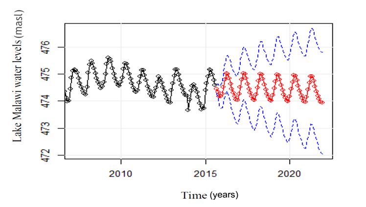
this model. The graph in Figure 5 also shows actual riparian shade may disappear. The loss of aquatic
catches and the forecasted trend being within the vegetation negatively affects fisheries resources
confidence interval of 95%. Czerwinski et al. as they act as breeding grounds for some of the
(2007), Singini et al. (2012) and Lazaro and Jere economically import fish species such as the
(2013) reported that a good model should have a Oreochromis spp. The same vegetation provides
low forecasting error, therefore when the distance a good habitat and nursery ground for the juvenile
between the forecasted and actual values were low fish which migrate into the lake after growing.
then the generated model had a good forecasting The receding of the lake due to drop in water level
power. Consequently, the selected model was used may as well affect fish breeding grounds (nests)
to forecast Lake Malawi water levels as shown in of the shallow dwelling species especially in the
Figure 5. long term. In the long run, the drop in lake water
levels may negatively affect fish populations.
The forecast showed that the water level in Logez et al. (2016) made a similar observation
Lake Malawi will likely have a mean of 474.45 that the habitat effect on assemblage structure
masl by the year 2021, while mean of the actual was strongest when the water-level conditions
recorded data was 474.6 masl, which is below the were high and very high, and weaker for low
actual recorded mean by 0.15 masl and 0.69 masl and very low water-level conditions. Lake water
from the maximum (475.14 masl) ever recorded level fluctuations (recession and refilling) have
water level in Lake Malawi. Figure 5 shows the provided numerous opportunities for the Mbuna to
forecasted trend of Lake Malawi through 2021. establish different founder population leading to
speciation (Owen et al., 1990). There are over 200
These results demonstrate that the water levels rock dwelling species (Mbuna) in Lake Malawi
in Lake Malawi might drop below the long-term whose mitochondrial DNA differentiation shows
mean recorded for the lake. This corroborates that their whole flock is extremely of recent origin.
the personal observations at Senga Bay Fisheries Water-level fluctuations affect the ecological
Research Centre in Salima District that indicate processes and patterns of lakes in several ways
that the shore line of the lake has receded by (Wantzen et al., 2016). Laë (1994) reported that
837838 Table 1. Selected competing models’ variables with their AIC generated from monthly Lake Malawi water levels
SARIMA Se SARIMA Se SARIMA Se SARIMA Se SARIMA Se
(0, 1, 1) (0, 1, 2) (1, 1, 0) (1, 1, 1) (1, 1, 0)
(1, 1, 1)12 (1, 1, 1)12 (1, 1, 1)12 (1, 1, 1)12 (2, 1, 1)12
Constant
L1. AR 0.2720 0.0522 0.2661 0.1834 0.2752 0.0522
L1. MA 0.2544 0.0493 0.2727 0.0544 0.0063 0.1905
L2. MA 0.0776 0.0545
L1. SAR -0.2438 0.0567 -0.2317 0.0577 -0.2324 0.0562 -0.2327 0.0574 -0.2180 0.0568
L2. SAR 0.1061 0.0657
L1. SMA -0.9991 0.0625 -0.9990 0.0665 -0.9990 0.0662 -0.9990 0.0661 -0.9994 0.0480
ME -0.5549746 -0.5179501 -0.3476219 -0.5113396 -0.3457697
MAE 0.6126432 0.580155 0.4196812 0.5737838 0.4139066
MAPE 423.8729 395.0768 282.5719 389.518 279.1434
RMSE 0.800835 0.7553016 0.5309216 0.7471556 0.524839
AIC -659.44 -659.46 -661.31 -659.31 -661.93
Model with the lowest AIC is the best fit
The fitted model was used to forecasts for Lake Malawi water levels from September, 2016 to 2021 at a confidence interval of 95% and they included
a zero (0).
M. MULUMPWA et al.
Figure 5. Forecasted Lake Malawi Water levels using SARIMA (1, 1, 0) (2, 1, 1)12Modelling and forecasting Lake Malawi water level fluctuations using stochastic models
lowest flood years resulted in decline in fish CONCLUSION
landings by 40,000 metric tons in Mali. A relatively extensive literature base already
exists for shallow lakes, demonstrating that
The forecasted trend of dropping water levels excessive water level fluctuations impair
is likely to affect, for instance, the hospitality ecosystem functioning, ultimately leading to
operators such as lodges, guest houses, hotels, shifts between clear-water and turbid states.
among other users that rely on water from the Lake Malawi water levels is notably fluctuating
lake. These operators and the those involved posing an increasing worry to some of the lake
in irrigation might require to extend their water users. The forecast for Lake Malawi water
extraction pipes from time to time as they follow levels showed that the water levels will relatively
the receding water of the lake. The user groups drop by 0.15 masl as compared to the mean
of Shire river are expected to be negatively water levels recorded in the previous years. This
affected by the forecasted dropping of Lake is likely to have negative implications over use
Malawi water levels as the river draws most of of Lake Malawi and Shire river that flow out of
its water from the Lake Malawi. The potential it for irrigation, pumping of water for domestic
effects of the dropping lake water levels in the use and hydroelectric power generation among
lake can be grouped into long term and short others. This calls for practices and policies that
term impacts. Hofmann et al. (2016) reported promote watershed approach to land and water
that large-scale shore line displacements change resource conservation to ensure sustainable
the habitat availability for organisms adapted resource management and enhance water
to terrestrial and aquatic conditions over long recharge to the lake.
time scales. Short-term water level fluctuation,
in contrast, do not significantly displace the ACKNOWLEDGEMENT
boundary between the aquatic and the terrestrial We thank Water the Resources Department in
habitat, but impose short-term physical stress the Ministry of Agriculture, Irrigation and Water
on organisms. There is therefore need to put Development for providing the data used in this
in place strategies to counteract the impacts study.
of climatic and anthropogenic activities on
the lake’s water level fluctuations. Poor crop STATEMENT OF NO-CONFLICT OF INTEREST
husbandry practices in the catchment areas are The authors declare that there is no conflict of
increasingly silting rivers hence cause them interest in this paper.
to flood and spill most of the water instead
of conveying adequate water to the lake. REFERENCES
Afforestation and reforestation programme Akaike, H. 1973. Information theory and
should be encouraged in the catchment areas an extension of the maximum likelihood
to enhance ground water recharge. The release principle. Budapest: Akademiai Kiado.
of water at Liwonde barrage on Shire river Box, G. E. P. and Jenkins, G.M. 1976. Time
should be regulated to maintain the water level series analysis: Forecasting and control.
on Lake Malawi for extended period. Parry and Holden-Day, San Francisco.
Burton (2009) recommended several options for Craine, M. 2005. Modelling Western Australian
controlling water levels in Lake Malawi, among Fisheries with techniques of time series
them, refurbishment of Kamuzu Barrage and analysis: Examining data from a different
construction of a high dam at Kholombidzo to perspective. Department of Fisheries
stabilize water level in the Lake and Shire river Research Division, Western Australian Marine
while in turn stabilizing hydropower generation. Research Laboratories, Western Australia
839M. MULUMPWA et al. 6920. FRDC Project No. 1999/155. ISBN No. of a lack of fit in time series models. Biometrika 1 877098 71 X 65 (2): 297–303. Czerwinski, I.A., Juan Carlos Guti´errez-Estrada, Logez, M., Roy, R., Tissot, L. and Argillier, C. J.C. and Hernando-Casal, J.A. 2007. Short- 2016. Effects of water-level fluctuations on term forecasting of halibut CPUE: Linear and the environmental characteristics and fish- non-linear univariate approaches. Fisheries environment relationships in the littoral zone Research 86: 120–128. of a reservoir. Fundamental and Applied Department of Fisheries, 2012. National Fisheries Limnology/Archiv für Hydrobiologie. DOI: Policy 2012 – 2017. Department of Fisheries, 10.1127/fal/2016/0963 Lilongwe. Malawi. Makridakis, S., Wheelwright, S. C. and Mcgee, V. Dickey, D. A. and Fuller, W. A. 1979. Distribution E. 1983. Forecasting methods for management. of the estimators for autoregressive time series John Wiley & Sons, New York – Chichester – with a unit root. Journal of the American Brisbane – Toronto – Singapore. Statistical Association 74 (366): 427–431. Owen, B. R., Crossley, R., Johnson, T. C., Gutierrez-Estradade Pedro-Sanz, J.C., Opez- Tweddle, D., Kornfield, I., Davison, S., Eccles, Luque, E. L. and Pulido-Calvo, I. 2004. D. H. and Engstrom, D. E. 1990. Major low Comparison between traditional methods levels of Lake Malawi and their implications and artificial neural networks for ammonia for speciation rates in cichlids fishes. Proc. R. concentration forecasting in an eel (Anguilla Soc. Lond. B 240. 519-553. L.) intensive rearing system. Aquat. Eng. 31: Parry, D. and Burton, K. 2009. Impact assessment 183–203. case studies from southern Africa. Lake Malawi Hofmann, H., Lorke, A. and Peeters, F. 2016. Level Control- Integrated water resource Temporal scales of water-level fluctuations development plan for Lake Malawi and Shire in lakes and their ecological implications. In: river systems. Southern Africa Institute for Wantzen, K. M., Rothhaupt, K., Mo¨rtl, M., Environmental Assessment. Cantonati, M., G.-To´th, L. and Fischer, P. Patterson, G. and Kachinjika, O. 1995. Ecological effects of water-level fluctuations in Limnology and phytoplankton ecology. pp 307- lakes. Hydrobiologia (2008) 613:85–96. DOI 349. In: Menz, A. (Ed.), The Fishery Potential 10.1007/s10750-008-9474-1. and Productivity of the Pelagic zone of Lake Kanyerere, G. Z. 2001. Spatial and temporal Malawi/Niassa. Natural Resources Institute, distribution of some commercially important Chatham, UK. fish species in the southeast and southwest Potier, M. and Drapeau, L. 2000. Modelling and arms of Lake Malawi: A geostatistical analysis. forecasting the catch of scads (Decapterus BSc. Thesis. Rhodes University. macrosoma, Decapterus russelii) in the Laë, R. 1994. Effect of drought, dams and fishing Javanese purse seine fishery using ARIMA pressure on the fisheries of the Central Delta time series models. Asian Fisheries Science on the Niger River. International Journal of 13: 75-85. Ecology and Environmental Sciences 20: 119- Satya, Pal, Ramasubramanian, V. and Mehta, 12. S.C. 2007. Statistical models for forecasting Lazaro, M. and Jere, W.W.L. 2013. The status milk production in India. J. Ind. Soc. Agril. of the commercial Chambo (Oreochromis Statist. 61 (2): 80-83. (Nyasalapia) species) fishery in Malawi: A Singini, W., Kaunda, K., Kasulo, V. and Jere, time series approach. International Journal of W., 2012. Modelling and forecasting small Science and Technology 3 (6):322-327. haplochromine species (Kambuzi) production Ljung, G.M. and Box, G.E.P. 1978. On a measure in Malawi – A stochastic model approach. 840
Modelling and forecasting Lake Malawi water level fluctuations using stochastic models

 International Journal of Scientific          and    Ecological effects of water-level fluctuations in
 Technology Research 1 (9): 69-73.                   lakes: an urgent issue. Hydrobiologia 613:1–4.
Wantzen, K. M., Rothhaupt, K., Mo¨rtl, M.,           DOI 10.1007/s10750-008-9466-1
 Cantonati, M., G.-To´th, L. and Fischer, P. 2016.

                                                                                                 841
You can also read