Mohammed Alam, Yolanda Alberto, Chrysl Aranha, Victor Calderon, Diego
←
→
Page content transcription
If your browser does not render page correctly, please read the page content below
Mohammed Alam, Yolanda Alberto, Chrysl Aranha, Victor Calderon, Diego
           Cordero-Carballo, Guillermo Diaz-Fanas, Wilfrid Djima, Erica Fischer, Mikael Gartner, Manny
             Hakhamaneshi, Ana Gabriela Haro, Wael Hassan, Preetish Kakoty, Said Maalouf, Amory
           Martin, Harish Mulchandani, Sissy Nikolaou, Angel Perez-Irizarry, Jenny Ramirez, Christopher
                             Segura, Mehmet Unal, Hartanto Wibowo, and David Yoo

Please Note: This report is based on publicly available data within 48 hours of the events. The assessment
 provided in the report is performed by the judgment of the authors with limited access to ground-truthing.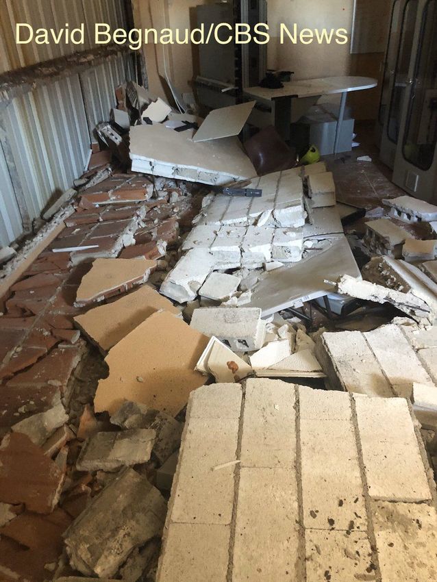
•

•
•

●
●
●
●
●

●

●
Historical evidence prior to 2019 shows 5
destructive earthquakes that were along the major
fault boundaries of the NE Caribbean and the
internal blocks of the plate boundary zones.
The 5/2/1787 EQ was felt throughout the island and
damaged colonial buildings, especially in San Juan.
The 11/18/1867 Anegada EQ damaged significantly
the Virgin Islands and generated a destructive
tsunami of height up to 6 m. The 10/11/1918 Mona
EQ reached intensities of up to IX with a major
tsunami that claimed at least 40 lives. Other
significant events have occurred in 1615, 1740,
1844, 1846, 1865, 1869, 1875, 1906, 1909, 1920,
1943, 1946, 1981 and 1987.
The 1/13/2014, is the first major M6 event recorded
by the PRSN (Puerto Rico Seismic Network) since
its establishment in the mid 70's.
References

https://earthquake.usgs.gov/earthquakes/eventpage/pt20007009/shakemap/intensity

   https://earthquake.usgs.gov/earthquakes/eventpage/pt20007009/moment-tensor

              https://www.complex.com/life/2020/01/puerto-rico-earthquake-aftershocks-dead-injured

                                         https://www.bbc.com/mundo/noticias-america-latina-51026064

https://wgntv.com/2020/01/07/6-4-magnitude-earthquake-strikes-puerto-rico/

               https://www.catholicnewsagency.com/news/archbishop-calls-for-prayer-solidarity-after-puerto-rico-earthquakes-38001
● Puerto Rico’s building code was last revised in 2018, significantly revised since 2011.
The codes include hazard resistant provisions that provide for safer construction in all
of the island’s 78 municipalities. The current code is following the IBC model code.
● FEMA provided $79 million funding for the building code update and improve code
enforcement through the Hazard Mitigation Grant Program (HMGP) that enables the
Planning Board and Office of Permit Management to grow their staff of 11 code
compliance officers to more than 200.
● Code update focused more on wind design, with 316 wind microzone maps for each
municipality.
● The code enforcement and code update projects modernize Puerto Rico’s building
design and regulation practices. The projects represent a small part of the $3 Billion in
hazard mitigation grant funding made available to PR to reduce the risk of loss of life
and property from the next disaster.●
●
○
○
●
○
○References
https://hazards.atcouncil.org/#/seismic?lat=17.9941326&lng=-66.8193421&address=Indios
%2C%20Guayanilla%2C%20Puerto%20Rico
https://www.washingtonpost.com/national/puerto-rico-earthquake/2020/01/07/0cbe4c9
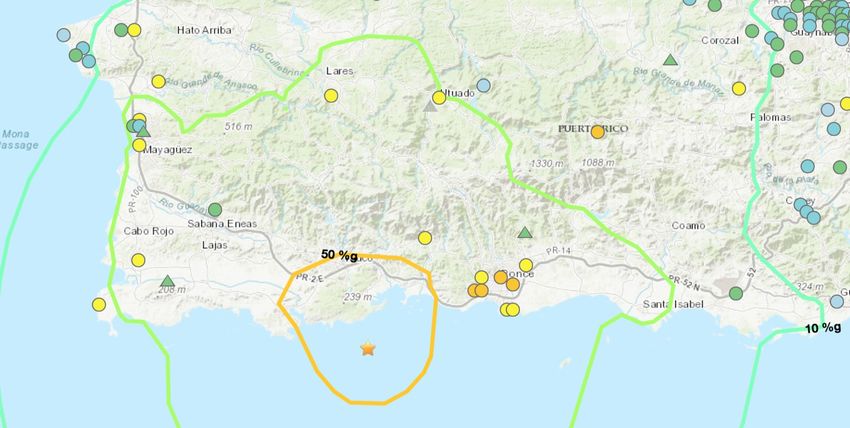
2-3143-11ea-9313-6cba89b1b9fb_story.htmlMagnitude (M) Day Time (UTC) Location Depth (km)
5.6 01/07/2020 08:34:02 17.922°N 66.731°W 10
5 01/07/2020 08:50:45 17.953°N 66.677°W 10
4.5 01/07/2020 11:14:50 17.909°N 66.744°W 10
5.6 01/07/2020 11:18:43 18.022°N 66.776°W 9
4.7 01/07/2020 12:54:42 17.931°N 66.927°W 8
4.5 01/07/2020 13:00:22 18.014°N 66.750°W 9
4.6 01/07/2020 14:04:45 17.878°N 66.796°W 10.7
4.6 01/07/2020 16:27:07 17.965°N 66.826°W 8● Over the week following the Jan 7 quake, there is a
7% chance of one or more aftershocks that are
larger than 6.4M. It is highly likely that there will
also be many smaller earthquakes (M>3) in this
period [2].
● In the first 24 hours, 50 seismic events with
magnitude 2.5 or higher, with 29 events more than
magnitude 4 was experienced in the region.
However, no tsunami threat was declared [3].
● Series of aftershocks have resulted in people
fearing to get back inside and using outdoor
shelters instead.References [1] https://earthquake.usgs.gov [2] https://www.usgs.gov/news/magnitude-64-earthquake-puerto-rico [3] https://earthquake.usgs.gov/earthquakes/eventpage/us70006vll/executive
References
[1] Star Tribune, “6.4 quake strikes Puerto Rico amid heavy seismic activity,” retrieved Jan. 8,
2020:http://www.startribune.com/6-6-quake-strikes-puerto-rico-amid-heavy-seismic-activity/5667
72562/
[2] EFE (English edition), “Historic church from 1841 destroyed in Puerto Rico quake,” retrieved
Jan. 8, 2020:
https://www.efe.com/efe/english/portada/historic-church-from-1841-destroyed-in-puerto-rico-qua
ke/50000260-4145195
[3] Noticel, “Fueron 11 las casas afectadas por el temblor en Guánica,” retrieved Jan. 8, 2020:
https://www.noticel.com/la-calle/fueron-11-las-casas-afectadas-por-el-temblor-en-guanica/11561
37566
[4] Twitter, Handle @GAlvarado_END, retrieved Jan. 8, 2020:
https://twitter.com/GAlvarado_END/status/1214502300334673920
[5] El Nuevo Dia, , “Así quedó el Ponce Darlington luego del terremoto,” retrieved Jan. 8, 2020:
https://www.elnuevodia.com/videos/asiquedoelponcedarlingtonluegodelterremoto-video-260864/
●
    ○

    ○
    ○
References
●   More than 85% of the population lives within 7 km of the coast, heavily
    dependent on tourism from the beaches and coral reefs.
●   In the 1950's and 60's, PR enjoyed a construction boom, and sand and gravel
    were mined from beaches and rivers, causing environmental damage with beach
    erosion and loss of sand to nourish beaches.
●   Studies suggest that PR will exhaust its known supplies of onshore sand and
    gravel by the turn of the century.
Puerto Rico has a complex geology, with historic developments as follows:
● 130 MYA (very early Cretaceous) - the beginning of submarine volcanism with
local build up of volcanic material.
● 120 MYA (early Cretaceous) - submarine volcanic material continues to
accumulate and build up.
● 100 MYA (late Cretaceous) - sea floor and submarine surfaces continue to built
up
● 90 MYA (early late Cretaceous) - small volcanic island appears above sea level,
the ancestral predecessor of Puerto Rico.
● 70 MYA (end of late Cretaceous) - extensive volcanism occurs
● 60 MYA (Paleocene - early Eocene) - first major tectonic activity era: volcanic
rocks are uplifted and eroded, becoming the source rocks for the Eocene
sediments found in PR today. The island is uplifted with major NW trending
strike-slip faulting.● 50 MYA (middle Eocene) - sedimentary rocks are deposited throughout southern
Puerto Rico.
● 40 MYA (late Eocene) - 2nd major tectonic activity. Island was re-elevated to
alpine heights with recurrence of faulting along preexisting faults. The Esneralda
fault zone developed at this time, which is the last time that major stike-slip
movement occurred at the south coastal region. The Juana Diaz formation
(conglomerate, shale, limey shale) formed.
● 25 MYA (late Oligocene - early Miocene) - 3rd major tectonic activity ear, with
recurrence of faulting along preexisting northwest trending zones, but new faults
also formed. The Ponce limestone formation formed.● 15 MYA (late Miocene or younger) - 4th major tectonic activity. The island was
reelevated with consequent reactivation of some old faults and the development
of new ones. Block faulting with displacements up to 200 m (630 ft) occurred.
Large stresses from the boundary troughs and trenches (Puerto Rico trench,
Mona Passage, and Anedaga trough).
● 1-3 MYA (Pleistocene-recent) - the island is relatively stable, but continues to be
under stresses with movement to the north, east-west, and south caused by
Mona Passage, Puerto Rico trench, and Anedaga trough.References
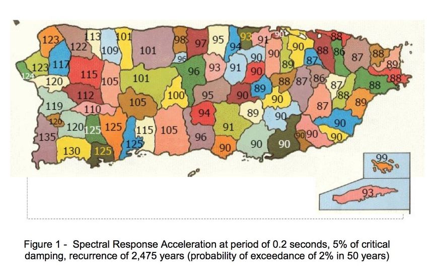
●

●

●

●

●
●

    ○
    ○
    ○
    ○
    ○
●
    ○
    ○
    ○
    ○
    ○
    ○
    ○
    ○
    ○
●
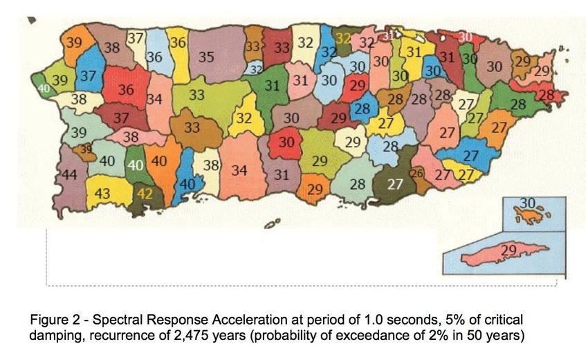
●
●
●
○
○
○●
●
    ○
    ○
    ○
●

●

●

●
References
https://twitter.com/ACUEDUCTOSPR/status/1214695541424185348?s=20
[8] https://twitter.com/jeremyscheuch/status/1214885419176865793?s=20
[9]
https://www.usatoday.com/story/news/nation/2020/01/07/puerto-rico-earthquake/2830673001/
[10] https://twitter.com/AHappyMargarita/status/1214734593963769857?s=20
[11] https://twitter.com/IP_Observatory/status/1215083740201807872?s=20
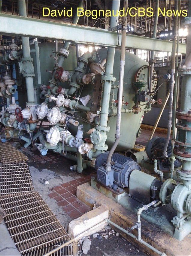
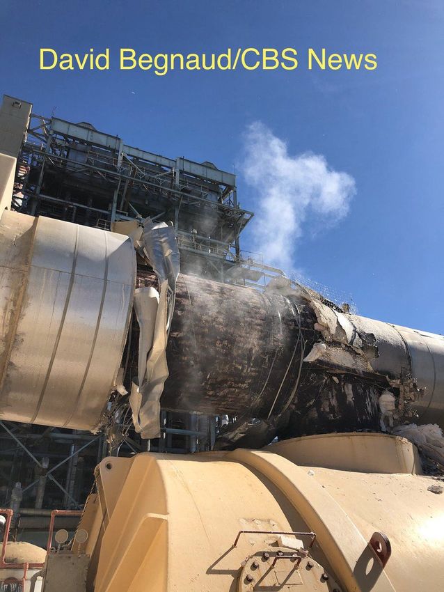
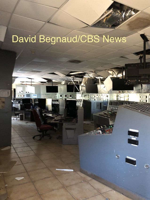
[12] Twitter, Handle @DavidBegnaud (David Begnaud, CBS correspondent):
https://twitter.com/DavidBegnaud/status/1215103744582520833
[13] Twitter, Handle @DavidBegnaud (David Begnaud, CBS correspondent): Twitter (David Begnaud, local CBS correspondent):
https://twitter.com/DavidBegnaud/status/1215012595226304513
[14] Twitter, Handle @DavidBegnaud (David Begnaud, CBS correspondent): Twitter (David Begnaud, local CBS correspondent):
https://twitter.com/DavidBegnaud/status/1215250790576803841● ● ● ● ● ●
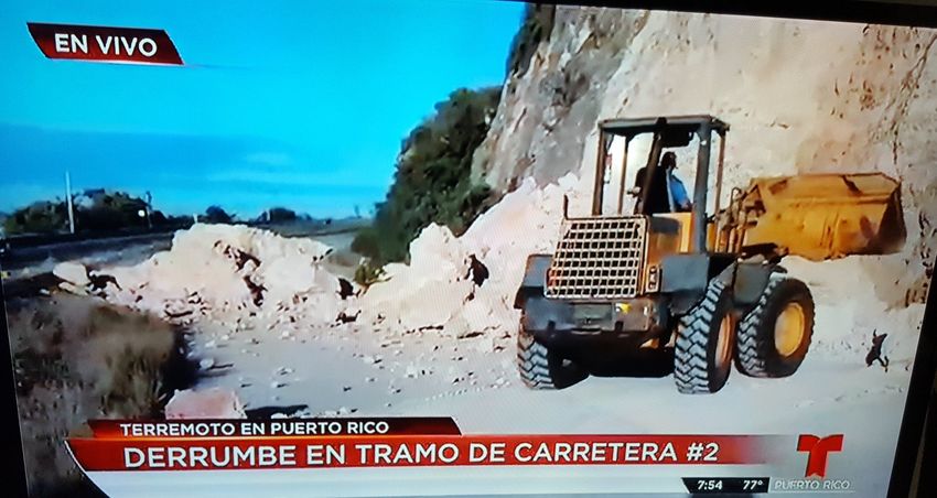
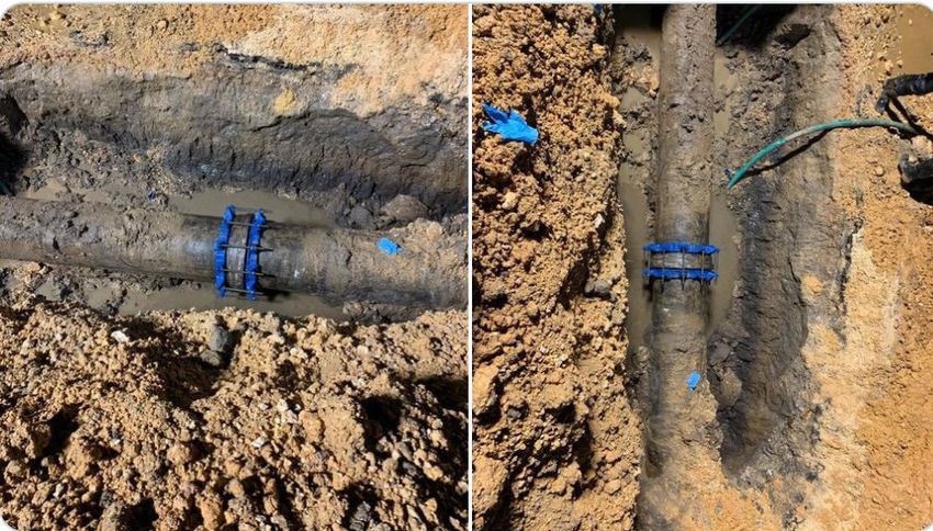
Viaducto Bridge @ PR-2 Mayagüez, PR Column and Cap Beam failure [6].
Column damage in a bridge on PR-52 in Ponce (Photos:Luis Aponte)
References
[1] https://www.elnuevodia.com/noticias/locales/nota/cierranparcialmentelapr-2alaalturadelviaductoenmayaguez-2539216/
[2] https://www.miamiherald.com/news/business/tourism-cruises/article239027238.html

[3] https://www.nbcbayarea.com/news/national-international/photos-strong-earthquakes-shake-puerto-rico/2211529/

[4] https://www.efe.com/efe/english/portada/historic-church-from-1841-destroyed-in-puerto-rico-quake/50000260-4145195

[5]https://www.elnuevodia.com/noticias/locales/nota/eldtopmantienecerradascuatroviasdetransitodebidoadanosporterremoto-2539498/#cxrec
s_s

[6] https://www.facebook.com/100004049570386/posts/1876800032464964/?sfnsn=mo
●
    ○

●
    ○
●
    ○
●
●
●
●
○
○
●
○
○
○● ● ●
●   An operational 3-story reinforced concrete school (The Agripina Seda
    School) collapsed following the Mw 6.4 1/7/2020 earthquake. [1]
●   The school serves 274 students (6th to 8th grades). [4]
●   At the time of the earthquake, the school was closed for the Christmas
    holiday. Return to classes has been delayed island-wide from January     [1]
    9th to the 13th. [4]
●   Inspectors have been deployed to evaluate schools in the affected
    area. On Tuesday (1/7/2020), eleven schools with some level of
    structural damage had been identified, including another school in
    Guanica that reportedly experienced partial collapse (information
    unverified). [4]
●   Damage to at least 3 schools has been reported in Guanica. [7]
●   The Puerto Rico Department of Education released a statement that
    schools will not resume until all schools have been evaluated. School
    teachers and staff were told not to report to work, except at schools
    designated as shelter. [8]
                                                                              [5]
[Twitter, @alwayszab]
References
References
You can also read